
Mount Ararat facts for kids
Quick facts for kids Mount Ararat |
|
|---|---|
| Highest point | |
| Elevation | 5,137 m (16,854 ft) See Elevation section |
| Prominence | 3,611 m (11,847 ft) Ranked 48th |
| Listing | Country high point Ultra Volcanic Seven Second Summits |
| Geography | |

Mount Ararat
Location in Turkey
|
|
| Location | Iğdır and Ağrı provinces, Turkey |
| Parent range | Armenian Highlands |
| Geology | |
| Mountain type | Stratovolcano |
| Last eruption | July 2, 1840 |
| Climbing | |
| First ascent | 9 October [O.S. 27 September] 1829 Friedrich Parrot, Khachatur Abovian, two Russian soldiers, two Armenian villagers |
.jpg)
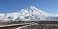
Mount Ararat (ARR-ə-rat) is a very tall, snow-covered volcano in eastern Turkey. It is currently sleeping, which means it is a dormant volcano. The mountain has two main peaks: Greater Ararat and Little Ararat.
Greater Ararat is the highest mountain in Turkey. It stands at about 5,137 meters (16,854 feet) tall. Little Ararat is a bit smaller, at 3,896 meters (12,782 feet). The base of the mountain is about 35 kilometers (22 miles) wide. People tried to climb Mount Ararat for many years. The first successful climb was in 1829 by Friedrich Parrot and Khachatur Abovian, along with four other people.
Many people believe Mount Ararat is where Noah's Ark landed after the great flood, as told in the Book of Genesis. Even though experts have different ideas, this belief is very strong in Christianity. Mount Ararat is also a special symbol for Armenians. It is seen as a sacred mountain and appears in their stories and art. The mountain is even on the Coat of Arms of Armenia.
Contents
Where Mount Ararat Is Located
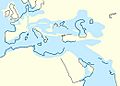
Mount Ararat is located where four countries almost meet: Turkey, Armenia, Azerbaijan, and Iran. The very top of the mountain is about 16 kilometers (10 miles) west of the Iranian border. It is also about 32 kilometers (20 miles) south of the Armenian border.
For a long time, from the 1500s until 1828, Mount Ararat was part of the border between the Ottoman Empire (now Turkey) and Persia (now Iran). Later, some parts of the mountain became part of the Russian Empire. Over the 1900s, the borders changed again. Today, the mountain is fully inside Turkey.
Climbing Mount Ararat is still quite special. As of 2004, you need special permission from the Turkish government to climb it. You also need to hire an official guide.
Different Names for Mount Ararat
The name Ararat comes from the ancient kingdom of Urartu. This kingdom was in the same area from the 9th to 6th centuries BC. Some people think the name "Ararat" might mean "holy ground."
The traditional Armenian name for the mountain is Masis (Մասիս). Today, Armenians use both Masis and Ararat. The highest peak is often called Mets Masis (Great Masis), and the smaller peak is called Sis or P′ok′r Masis (Little Masis).
In Turkish, the mountain is called Ağrı Dağı. This means "Mountain of Ağrı," which is a nearby city. The word "Ağrı" also means "pain" or "sorrow" in Turkish. The Kurdish name is çiyayê Agirî which means "fiery mountain." The Persian name is Kūh-e Nūḥ, which means "mountain of Noah."
What Mount Ararat Looks Like
Mount Ararat is in the eastern part of Turkey. It sits between the Ağrı and Iğdır areas. It is also close to the borders of Iran, Armenia, and Nakhchivan (part of Azerbaijan). The Aras and Murat rivers flow nearby.
How Tall is Mount Ararat?
Some books say Mount Ararat is 5,165 meters (16,946 feet) tall. However, many maps and surveys, like those from the United States Geological Survey, show that 5,137 meters (16,854 feet) is more accurate. The mountain's height might even be a bit less now, around 5,125 meters (16,814 feet), because its ice cap is melting.

The Ice Cap on Top
The ice and snow on top of Mount Ararat have been shrinking. In the 1950s, the ice cap covered about 10 square kilometers (3.9 square miles). By 1976, it had shrunk to 8.0 square kilometers (3.1 square miles). By 2011, it was only 5.7 square kilometers (2.2 square miles). This means the ice cap lost 29% of its size between 1976 and 2011. This melting is similar to what is happening on other glaciers in Turkey.
How Mount Ararat Was Formed

Mount Ararat is a type of volcano called a stratovolcano. It is the largest volcano in its region, covering about 1,100 square kilometers (420 square miles). The mountain is about 45 kilometers (28 miles) long and 30 kilometers (19 miles) wide. It is made up of different kinds of volcanic rock, like lava and ash.
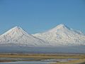
Mount Ararat has two main volcanic cones: Greater Ararat and Lesser Ararat (Little Ararat). Greater Ararat is the bigger, steeper cone. It is about 25 kilometers (16 miles) wide at its base and rises about 3 kilometers (1.9 miles) above the surrounding plains. Lesser Ararat is 3,896 meters (12,782 feet) high and about 15 kilometers (9.3 miles) wide.
These two cones are about 13 kilometers (8.1 miles) apart. They are separated by a large crack in the ground. Many smaller volcanoes and lava flows have formed along this crack and on the sides of the main cones.
Mount Ararat sits in an area where the Earth's plates are moving and pushing against each other. This movement created cracks and valleys in the land. The volcano grew in one of these areas, and its eruptions helped shape the landscape around it.
Gallery
-
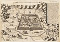
Topography of Paradise by Athanasius Kircher (1675). It shows Mount Ararat with Noah's Ark on top.
-
Descent of Noah from Ararat by Ivan Aivazovsky (1889). It shows Noah and his family leaving the Ark.
-
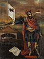
Hayk, the legendary father of the Armenian people, with Ararat in the background.
-

Lebanese Armenians protesting in 2010. The poster says "Ararat is and remains Armenian".
-
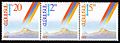
The first stamps issued by independent Armenia in 1992.
-

The Russian poet Aleksandr Pushkin wrote about Ararat.
-
The Coat of Arms of the First Republic of Armenia (1918–20).
-
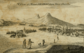
A drawing of Ararat from 1718 by Joseph Pitton de Tournefort.
-
A view of Ararat from 1821 by Robert Ker Porter.
-
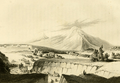
A view from 1846, from Friedrich Parrot's book Journey to Ararat.
-
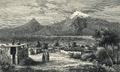
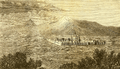
A view from 1877 by James Bryce.
-
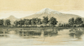
A view from 1901 by H. F. B. Lynch.
-
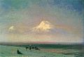
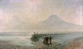
Valley of Mount Ararat by Ivan Aivazovsky, 1882.
-
Ararat from Ejmiatsin by Yeghishe Tadevosyan, 1895.
-
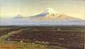
A painting by Gevorg Bashinjaghian, 1912.
-
A painting by Panos Terlemezian, 1929.
-
Mount Ararat seen from the International Space Station in 2011.
-
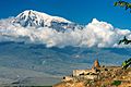
A view of Ararat from Khor Virap, Armenia.
-
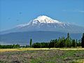
A view of Ararat from Iğdır, Turkey.
-
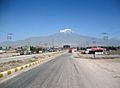
A view from Doğubeyazıt.
-
A view from Iğdır.
-
A view from Nakhchivan.
_-_topographia_paradisi.jpg)


.jpg)


.jpg)


Images for kids
-
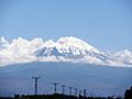
View from Turkey
-
Paleogeography of the early Oligocene
-
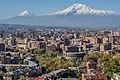
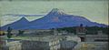
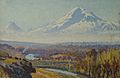
Ararat dominates the skyline of Armenia's capital Yerevan.
-
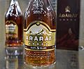
The mountain is featured on the Ararat brandy.
-
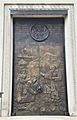
Ararat depicted on the wooden door of St. Vartan Armenian Cathedral in New York City.
-
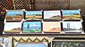
Paintings of Mount Ararat for sale at the Yerevan Vernissage.
-
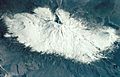
From the Space Shuttle, 18 March 2001
-
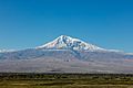
View of Ararat from Khor Virap, Armenia


_bottles.jpg)


See also
 In Spanish: Monte Ararat para niños
