
Niagara Falls, New York facts for kids
Quick facts for kids
Niagara Falls
|
|||
|---|---|---|---|

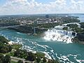
The city of Niagara Falls viewed from the Skylon Tower. In the foreground are the American Falls (left) and Bridal Veil Falls (right).
|
|||
|
|||
| Nickname(s):
Niagara Falls USA Honeymoon Capital of the World |
|||

Location in Niagara County and the state of New York.
|
|||

Niagara Falls
Location in New York

Niagara Falls
Location in the United States
|
|||
| Country | |||
| State | |||
| County | Niagara | ||
| Settled | 1679 | ||
| Incorporated as a city | March 17, 1892 | ||
| Government | |||
| • Type | Strong mayor-council | ||
| Area | |||
| • City | 16.83 sq mi (43.58 km2) | ||
| • Land | 14.09 sq mi (36.48 km2) | ||
| • Water | 2.74 sq mi (7.10 km2) 16.37% | ||
| • Urban | 366.7 sq mi (949.7 km2) | ||
| Elevation | 614 ft (187 m) | ||
| Population
(2020)
|
|||
| • City | 48,671 | ||
| • Rank | NY: List of cities in New York (state) 34th (2010) | ||
| • Density | 3,455.27/sq mi (1,334.09/km2) | ||
| • Urban | 935,906 (US: 46th) | ||
| • Urban density | 2,663.5/sq mi (1,028.37/km2) | ||
| • Metro | 1,134,155 (US: 50th) | ||
| • CSA | 1,206,992 (US: 47th) | ||
| Time zone | UTC-5 (EST) | ||
| • Summer (DST) | UTC-4 (EDT) | ||
| ZIP codes |
14301-14305
|
||
| Area code(s) | 716 | ||
| FIPS code | 36-51055 | ||
| GNIS feature ID | 0970406 | ||
| Demonym | Niagarian Niagara Fallsite |
||


Niagara Falls is a city in Niagara County, New York, United States. In 2020, about 48,671 people lived there. The city is right next to the Niagara River. It sits across from another city also called Niagara Falls, Ontario, in Canada. Both cities are named after the famous Niagara Falls they share.
Long ago, Native Americans lived in this area. In the mid-17th century, Europeans arrived and started businesses. They also built important structures. Later, in the 18th and 19th centuries, people learned to use the Niagara River's power. They used it to make electricity. This cheap power attracted many factories and businesses.
However, after the 1960s, the city's economy slowed down. Many industries left the area. Families moved away to find jobs elsewhere. Because of this, the city's population dropped a lot. In 1960, over 102,000 people lived here. By 2020, it was about 48,000. That's a drop of more than 50%!
Contents
History of Niagara Falls
Before Europeans came, the Neutral Nation of Native Americans lived here. Europeans started arriving in the 1600s. The first European known to visit was Robert de la Salle from France. In 1679, he built Fort Conti near the Niagara River. This was a base for building boats. His ship, Le Griffon, was built nearby.
A Belgian priest named Louis Hennepin traveled with de la Salle. He was the first European known to see the amazing falls. More newcomers arrived, which may have led to more fighting. Native tribes competed for the fur trade.
Becoming a City
The City of Niagara Falls officially became a city on March 17, 1892. It was formed from two villages: Manchester and Suspension Bridge. These villages were part of the Town of Niagara. Thomas Vincent Welch, a state assemblyman, helped make this happen. He convinced the Governor of New York, Roswell P. Flower, to sign the bill. This happened on St. Patrick's Day. George W. Wright became the first mayor.
By the late 1800s, the city had many factories. This was because the Niagara River could provide a lot of power. Tourism was not the main focus yet. Making chemicals, grinding materials, and metal products were the big industries. These jobs attracted many workers, including immigrants.

In 1927, the city added the village of La Salle. This village was named after Robert de la Salle.
Growth and Challenges
Factories and tourism grew steadily in the first half of the 1900s. There was a high demand for industrial products. Also, more people could travel easily. Paper, rubber, plastics, and chemicals were major industries.
However, this good time ended by the late 1960s. Old factories moved to cheaper places. Also, the falls were not good for modern shipping.
In 1956, the Schoellkopf Power Plant was badly damaged. The wall of the Niagara Gorge above it collapsed. This led to plans for a huge new hydroelectric plant. It was one of the biggest built in North America at that time. Many workers and families moved to the area. Robert Moses, a city planner, built the new plant in nearby Lewiston, New York. Much of the power went to New York City.
The neighborhood of Love Canal became famous in 1978. Toxic waste from a chemical dump was found underground. The U.S. President Jimmy Carter declared a state of emergency. This was the first time for a non-natural disaster. Hundreds of people had to leave their homes. Many were sick from the chemicals.

After the Love Canal disaster, the city faced more problems. Its population had already been shrinking. Factories closed because it was cheaper to make things elsewhere. Many workers left to find jobs. The city's economy fell even more. A plan to rebuild the city center failed.
In 2010, the New York State Attorney General made an agreement with the city. They worked with the police department. New rules were made to prevent police misconduct. The city promised to train police better. They also agreed to investigate complaints properly.

In 2020, a public square called Cataract Commons opened. It is on Old Falls Street. This is a public space for outdoor events.
The city has many places listed on the National Register of Historic Places. These are important historical sites. It also has three national historic districts. These include Chilton Avenue-Orchard Parkway Historic District, Deveaux School Historic District, and the Park Place Historic District.
Geography and Climate
Niagara Falls is located on the border between the United States and Canada. It is part of the Buffalo–Niagara Falls metropolitan area. The city is about 16 miles (26 km) from Buffalo, New York.
The city covers about 16.9 square miles (43.8 km2). Most of this is land (14.1 sq mi or 36.5 km2). The rest is water (2.8 sq mi or 7.3 km2). The city is built along the Niagara Falls and the Niagara Gorge. This gorge is next to the Niagara River.
Climate in Niagara Falls
Niagara Falls has a humid continental climate. This means it has cold, snowy winters. Summers are very warm and humid. It rains or snows a moderate amount all year. Winters have more snow than many other U.S. cities. However, it gets less snow than Buffalo or Rochester. Temperatures often go above freezing in winter.
The hottest temperature recorded through 2015 was 97 °F (36 °C) in 2005. The coldest was −13 °F (−25 °C) in 2003. About 38% of summer rain comes from thunderstorms.
| Climate data for Niagara Falls International Airport (1991–2020 normals, extremes 1951–present) | |||||||||||||
|---|---|---|---|---|---|---|---|---|---|---|---|---|---|
| Month | Jan | Feb | Mar | Apr | May | Jun | Jul | Aug | Sep | Oct | Nov | Dec | Year |
| Record high °F (°C) | 65 (18) |
68 (20) |
81 (27) |
86 (30) |
93 (34) |
95 (35) |
97 (36) |
95 (35) |
96 (36) |
85 (29) |
80 (27) |
72 (22) |
97 (36) |
| Mean maximum °F (°C) | 54.1 (12.3) |
51.1 (10.6) |
64.5 (18.1) |
78.9 (26.1) |
85.8 (29.9) |
88.8 (31.6) |
91.3 (32.9) |
89.1 (31.7) |
87.0 (30.6) |
78.2 (25.7) |
66.4 (19.1) |
56.2 (13.4) |
92.3 (33.5) |
| Mean daily maximum °F (°C) | 31.5 (−0.3) |
32.7 (0.4) |
41.4 (5.2) |
54.5 (12.5) |
67.6 (19.8) |
76.3 (24.6) |
80.7 (27.1) |
79.1 (26.2) |
72.5 (22.5) |
59.5 (15.3) |
47.4 (8.6) |
36.7 (2.6) |
56.7 (13.7) |
| Daily mean °F (°C) | 24.2 (−4.3) |
25.0 (−3.9) |
33.0 (0.6) |
44.4 (6.9) |
56.6 (13.7) |
66.3 (19.1) |
71.0 (21.7) |
69.4 (20.8) |
62.3 (16.8) |
50.6 (10.3) |
39.7 (4.3) |
30.2 (−1.0) |
47.7 (8.7) |
| Mean daily minimum °F (°C) | 16.8 (−8.4) |
17.3 (−8.2) |
24.7 (−4.1) |
34.3 (1.3) |
45.7 (7.6) |
56.2 (13.4) |
61.2 (16.2) |
59.6 (15.3) |
52.2 (11.2) |
41.6 (5.3) |
31.9 (−0.1) |
23.7 (−4.6) |
38.8 (3.7) |
| Mean minimum °F (°C) | −1.3 (−18.5) |
−0.2 (−17.9) |
7.4 (−13.7) |
23.3 (−4.8) |
32.5 (0.3) |
44.6 (7.0) |
51.7 (10.9) |
50.2 (10.1) |
40.8 (4.9) |
28.7 (−1.8) |
18.9 (−7.3) |
8.4 (−13.1) |
−5.2 (−20.7) |
| Record low °F (°C) | −16 (−27) |
−13 (−25) |
−8 (−22) |
12 (−11) |
24 (−4) |
37 (3) |
46 (8) |
45 (7) |
30 (−1) |
23 (−5) |
−2 (−19) |
−4 (−20) |
−16 (−27) |
| Average precipitation inches (mm) | 2.27 (58) |
1.77 (45) |
2.12 (54) |
3.19 (81) |
3.03 (77) |
2.88 (73) |
3.37 (86) |
2.62 (67) |
3.27 (83) |
3.23 (82) |
2.78 (71) |
2.44 (62) |
32.97 (837) |
| Average precipitation days (≥ 0.01 in) | 15.0 | 12.5 | 12.1 | 13.4 | 12.8 | 11.6 | 11.5 | 10.5 | 10.8 | 15.3 | 12.6 | 15.5 | 153.6 |
| Source 1: NOAA | |||||||||||||
| Source 2: National Weather Service | |||||||||||||
| Climate data for Niagara Falls, New York (1991–2020 normals, extremes 1989–2019) | |||||||||||||
|---|---|---|---|---|---|---|---|---|---|---|---|---|---|
| Month | Jan | Feb | Mar | Apr | May | Jun | Jul | Aug | Sep | Oct | Nov | Dec | Year |
| Record high °F (°C) | 65 (18) |
70 (21) |
81 (27) |
93 (34) |
93 (34) |
95 (35) |
97 (36) |
95 (35) |
93 (34) |
85 (29) |
72 (22) |
72 (22) |
97 (36) |
| Mean daily maximum °F (°C) | 33.4 (0.8) |
34.5 (1.4) |
42.9 (6.1) |
55.8 (13.2) |
68.8 (20.4) |
77.6 (25.3) |
82.2 (27.9) |
80.4 (26.9) |
73.9 (23.3) |
61.2 (16.2) |
48.9 (9.4) |
38.5 (3.6) |
58.2 (14.6) |
| Daily mean °F (°C) | 26.0 (−3.3) |
26.7 (−2.9) |
34.4 (1.3) |
45.9 (7.7) |
58.3 (14.6) |
68.0 (20.0) |
72.8 (22.7) |
70.9 (21.6) |
63.7 (17.6) |
52.0 (11.1) |
41.2 (5.1) |
32.0 (0.0) |
49.3 (9.6) |
| Mean daily minimum °F (°C) | 18.6 (−7.4) |
18.8 (−7.3) |
26.0 (−3.3) |
36.0 (2.2) |
47.9 (8.8) |
58.3 (14.6) |
63.4 (17.4) |
61.4 (16.3) |
53.6 (12.0) |
42.8 (6.0) |
33.4 (0.8) |
25.4 (−3.7) |
40.5 (4.7) |
| Record low °F (°C) | −15 (−26) |
−13 (−25) |
−9 (−23) |
14 (−10) |
28 (−2) |
38 (3) |
44 (7) |
44 (7) |
26 (−3) |
24 (−4) |
7 (−14) |
−7 (−22) |
−15 (−26) |
| Average precipitation inches (mm) | 2.59 (66) |
2.10 (53) |
2.44 (62) |
3.10 (79) |
3.14 (80) |
2.99 (76) |
3.38 (86) |
2.80 (71) |
3.25 (83) |
3.27 (83) |
2.89 (73) |
2.76 (70) |
34.71 (882) |
| Average snowfall inches (cm) | 22.3 (57) |
16.3 (41) |
11.6 (29) |
2.2 (5.6) |
0.0 (0.0) |
0.0 (0.0) |
0.0 (0.0) |
0.0 (0.0) |
0.0 (0.0) |
0.2 (0.51) |
4.1 (10) |
15.7 (40) |
72.4 (184) |
| Average precipitation days (≥ 0.01 in) | 18.4 | 14.7 | 13.3 | 13.4 | 12.7 | 11.3 | 10.7 | 10.4 | 10.3 | 13.7 | 13.3 | 16.2 | 158.4 |
| Average snowy days (≥ 0.1 in) | 14.6 | 12.1 | 7.3 | 2.4 | 0.0 | 0.0 | 0.0 | 0.0 | 0.0 | 0.2 | 3.9 | 10.3 | 50.8 |
| Source: NOAA | |||||||||||||
City Neighborhoods
Niagara Falls has several distinct neighborhoods:
- Buffalo Avenue – This street runs along the Niagara River. It once had many grand homes. Further east, it becomes an industrial area.
- Central District – This is a key area of the city.
- Deveaux – This residential area is in the northwest. It was built between the 1920s and 1940s. It is named after Judge Samuel DeVeaux. He left his land to start a school for children in 1853.
- Downtown – This area is near the Falls. It has hotels like the Seneca Niagara Resort Casino. It also includes Niagara Falls State Park and the Niagara Falls Culinary Institute.
- East Side – This area is bordered by the gorge to the west.
- Hyde Park – This neighborhood is near Hyde Park, a large city park. It also has the Hyde Park Municipal Golf Course.
- LaSalle – This area was built up from the 1940s to 1960s. Cayuga Island is connected to this neighborhood. The Love Canal area is also here.
- Little Italy – This area was once home to many Italian families. It has many shops and restaurants.
- Love Canal – This neighborhood was built in the 1950s. It was on land bought from a chemical company. Most residents had to leave in the 1980s. This was after toxic waste was found underground. People began moving back in 1990.
- Niagara Street – This is a residential area east of Downtown. It was once home to many German and Polish families.
- North End – This area runs along Highland Avenue.
Population and People
| Historical population | |||
|---|---|---|---|
| Census | Pop. | %± | |
| 1870 | 3,006 | — | |
| 1880 | 3,320 | 10.4% | |
| 1890 | 5,502 | 65.7% | |
| 1900 | 19,457 | 253.6% | |
| 1910 | 30,445 | 56.5% | |
| 1920 | 50,760 | 66.7% | |
| 1930 | 74,460 | 46.7% | |
| 1940 | 78,020 | 4.8% | |
| 1950 | 90,872 | 16.5% | |
| 1960 | 102,394 | 12.7% | |
| 1970 | 85,615 | −16.4% | |
| 1980 | 71,384 | −16.6% | |
| 1990 | 61,840 | −13.4% | |
| 2000 | 55,593 | −10.1% | |
| 2010 | 50,193 | −9.7% | |
| 2020 | 48,671 | −3.0% | |
| U.S. Decennial Census | |||
In 2010, there were 50,193 people living in Niagara Falls. There were 22,603 households. About 12,495 of these were families. The city had about 2,988 people per square mile (1,154 per square km).
Most people (70.5%) were White. About 21.6% were African American. Other groups included Native American (1.9%), Asian (1.2%), and people of two or more races (3.9%). About 3.0% of the population was Hispanic or Latino.
About 23.9% of households had children under 18. About 29.8% were married couples. Around 19.7% were female-led households without a husband. About 44.7% were not families. Many households (38.1%) had only one person living there. About 13.7% had someone aged 65 or older living alone.

In the city, 22% of people were under 18. About 10.1% were 18 to 24 years old. The median age was 39 years. For every 100 females, there were about 91 males.
The average household income in the city was $26,800. For families, it was $34,377. About 23% of the population lived below the poverty line.
Niagara Falls has many places of worship. These include the Salvation Army and various churches. There are also Jewish temples like Temple Beth El.
Economy and Tourism

The main industry in Niagara Falls is tourism. People come from all over to see the famous waterfalls.
A report in 2012 said that Niagara Falls has faced challenges. It has lost people and seen rising crime. The city has tried to change from a factory town to a major tourist spot.
In the 1960s, the city grew fast. This was because the Robert Moses Niagara Power Plant opened. It made cheap electricity. This power helped many factories grow. But like other parts of Western New York, Niagara Falls saw a big economic decline by the 1970s.
Today, the city tries to compete with Niagara Falls, Ontario, in Canada. The Canadian side has higher average incomes and home prices. It also has fewer empty buildings and a stronger economy. The population of Niagara Falls, New York, dropped by half from the 1960s to 2012. In contrast, the population of Niagara Falls, Ontario, more than tripled.
Important parts of the local economy include the Niagara Falls International Airport. It was updated in 2009. The Seneca Gaming Corporation's Seneca Niagara Casino & Hotel also brings in money. It opened in the 2000s. The nearby Niagara Falls Air Reserve Station is also important.
In 2001, New York State created the USA Niagara Development Corporation. This group focuses on improving the downtown area. However, some people say it has not made much progress.
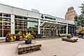
Convention Center
,_New_York.jpg)
From 1973 to 2002, the city had a Convention and Civic Center. In 2002, this building became the Seneca Niagara Casino & Hotel. In 2004, a new Niagara Falls Convention Center (NFCC) opened. It is on Old Falls Street. This new center has a large space for events and meetings.
Top Tourist Attractions
The city is home to the Niagara Falls State Park. This park has many fun attractions:
- Cave of the Winds is a path behind the Bridal Veil Falls.
- Maid of the Mist is a popular boat tour. It takes you close to the falls.
- Prospect Point has an observation tower with great views.
- The Niagara Discovery Center teaches about the falls.
- The Niagara Falls Underground Railroad Heritage Center tells important history.
- The Aquarium of Niagara lets you see marine life.
Other attractions near the river include Whirlpool State Park and De Veaux Woods State Park. Nearby towns have Earl W. Brydges Artpark State Park and Fort Niagara State Park.
In downtown Niagara Falls, you can visit the Seneca Niagara Casino & Hotel. Pine Avenue is also known as Little Italy. It has many shops and good restaurants.
Sports Teams
The Niagara Power baseball team plays at Sal Maglie Stadium. They are part of the New York Collegiate Baseball League. The team is owned by Niagara University.
The Cataract City Wolverines are a minor league football team. They played their first season in 2021.
In 2017, a junior ice hockey team moved to Niagara Falls. They are called the Niagara Falls PowerHawks.
Past sports teams in Niagara Falls include the Niagara Falls Sox and the Niagara Falls Rapids.
Education
Students in Niagara Falls go to schools in the Niagara Falls City School District. For higher education, Niagara University and Niagara County Community College are in Niagara County.
Media and News
Niagara Falls is part of the Buffalo–Niagara Falls metropolitan area. So, most of its media comes from Buffalo.
The city has two local newspapers. The Niagara Gazette is published almost every day. The Messenger Of Niagara Falls, NY is published four times a year. It is the first black-owned news publication in Niagara Falls. The Buffalo News is the closest major newspaper. The city also has a weekly paper called the Niagara Falls Reporter.
Three radio stations are licensed to Niagara Falls. These are WHLD AM 1270, WEBR AM 1440, and WKSE FM 98.5.
Transportation and Roads

For flights, people in Niagara Falls mainly use the Buffalo Niagara International Airport. The Niagara Falls International Airport also serves the city. It has flights to places like Myrtle Beach and Orlando. Toronto Pearson International Airport in Canada is nearby for international flights.
The city has train service from Amtrak. The Maple Leaf and Empire trains stop at the Niagara Falls Station and Customhouse Interpretive Center.
The Niagara Frontier Transportation Authority provides public bus service. They have hubs at Portage Road and Niagara Falls transportation centers.
Several major roads pass through Niagara Falls. These include New York State Route 31, New York State Route 104, and New York State Route 182. There are also north-south routes like New York State Route 61. The LaSalle Expressway is an east-west highway. The Niagara Scenic Parkway used to run along the Niagara River.

Interstate 190 is a major highway. It borders the eastern part of the city. U.S. Route 62 runs through the city. It is known by different names like Niagara Falls Boulevard. U.S. Route 62 Business is another important route.
Two international bridges connect Niagara Falls, New York, to Niagara Falls, Ontario. The Rainbow Bridge allows cars and people to cross. It offers views of the falls. The Whirlpool Rapids Bridge is used by local traffic and Amtrak trains.
Notable People
Images for kids
-
The city of Niagara Falls viewed from the Skylon Tower. In the foreground are the American Falls (left) and Bridal Veil Falls (right).
-
Flag of Niagara Falls
-
Seal of Niagara Falls, New York
-
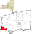
Location in Niagara County and the state of New York.
-
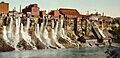
The Niagara Falls mill district downriver from the American Falls, 1900
-
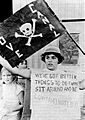
The contaminated neighborhood of Love Canal received national attention in 1978.
-

Cataract Commons
-
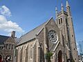
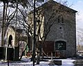
St. Peter's Episcopal Church
-
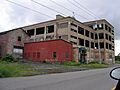
Abandoned industrial building within "Chemical Row" in Niagara Falls
-
Niagara Falls Convention Center (NFCC)
-
The Cave of the Winds building in the winter
-
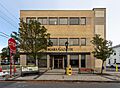
The Niagara Gazette is the city's daily newspaper.
-
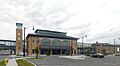
The current Niagara Falls station opened in 2016
-
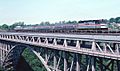
Whirlpool Rapids bridge, 1983


See also
 In Spanish: Niagara Falls (Nueva York) para niños
