
List of counties in New York facts for kids
Quick facts for kids Counties of New York |
|
|---|---|
 |
|
| Location | State of New York |
| Number | 62 |
| Populations | 5,082 (Hamilton) – 2,561,225 (Kings) |
| Areas | 33.77 square miles (87.5 km2) (New York) – 2,821 square miles (7,310 km2) (St. Lawrence) |
| Government | County government |
| Subdivisions | Cities, Towns, Indian Reservations |
New York State has 62 special areas called counties. These counties help organize the state. They also make it easier to manage local services and government.
The first 12 counties were made way back in 1683. This was soon after the British took over from the Dutch. Most counties were created in the 1800s. The newest county is the Bronx, formed in 1914. New York's counties got their names from many places. Some are from Native American words. Others are from British places or royalty. Many are named after important American leaders and politicians.
Contents
How Counties Are Governed in New York
Most New York counties have their own local governments. These governments follow New York County Law. They are usually run by a Board of Supervisors or a County Legislature. They also have an elected County Executive or a county manager.
Counties without a special plan (called a charter) have a Board of Supervisors. Town leaders from within the county also sit on this board. For counties with a charter, the county executive can say no to (veto) decisions made by the county legislature. These legislatures have the power to create rules, collect taxes, and give out money.
The court system and public lawyers (prosecutors) are also set up by county. People in each county vote for these officials.
New York City's Five Boroughs: Special Counties
Five of New York's counties are actually the same as New York City's five boroughs. These are:
- New York County (which is Manhattan)
- Kings County (which is Brooklyn)
- Bronx County (which is The Bronx)
- Richmond County (which is Staten Island)
- Queens County (which is Queens)
These five counties are different from other New York counties. The city government of New York City controls most things in these boroughs. The boroughs themselves have very limited powers.
Some officials are elected for each borough. For example, each borough has a Borough President. These presidents handle matters specific to their borough. Other officials, like district attorneys and judges, deal with state laws and local rules in their county/borough.
There are no official "county seats" in New York City. However, some neighborhoods act like informal county seats. This is because their borough halls and courthouses are located there:
- In the Concourse area of the Bronx, you'll find the Bronx County Courthouse.
- Brooklyn Borough Hall and the main courthouse are in Downtown Brooklyn.
- In Civic Center (downtown), you'll find the Manhattan Municipal Building and most courthouses.
- Queens Borough Hall and a courthouse are in Kew Gardens.
- On Staten Island, the Staten Island Borough Hall and courthouses are in the St. George neighborhood.
List of New York Counties
New York State has 62 counties, each with its own unique history and name. Here are a few examples:
| County |
County seat |
Est. |
Named for |
Pop. (2023) |
Area |
Map |
|
|---|---|---|---|---|---|---|---|
| Albany County | - | Albany | Nov 1, 1683 | James II of England, who was Duke of York and Albany | 316,659 | 533 sq mi (1,380 km2) |
|
| Bronx County | - | none (sui generis) | Jan 1, 1914 | Jonas Bronck, an early Dutch settler | 1,356,476 | 57.43 sq mi (149 km2) |
|
| Dutchess County | - | Poughkeepsie | Nov 1, 1683 | Mary of Modena, Duchess of York and wife of King James II of England | 297,150 | 825 sq mi (2,137 km2) |
|
| Erie County | - | Buffalo | Apr 2, 1821 | The Erie Native American tribe | 946,147 | 1,227 sq mi (3,178 km2) |
|
| Kings County | - | none (sui generis) | Nov 1, 1683 | King Charles II of England | 2,561,225 | 96.9 sq mi (251 km2) |
|
| New York County | - | none (sui generis) | Nov 1, 1683 | King James II of England, who was Duke of York | 1,597,451 | 33.77 sq mi (87 km2) |
|
| Queens County | - | none (sui generis) | Nov 1, 1683 | Catherine of Braganza, Queen of England | 2,252,196 | 178.28 sq mi (462 km2) |
|
| Suffolk County | - | Riverhead | Nov 1, 1683 | The county of Suffolk in England | 1,523,170 | 2,373 sq mi (6,146 km2) |
|
| Ulster County | - | Kingston | Nov 1, 1683 | The Irish province of Ulster | 182,333 | 1,161 sq mi (3,007 km2) |
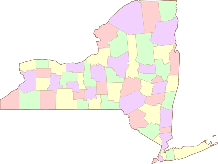
Clickable Map of New York Counties
Images for kids
-
Map showing all counties in New York State.
See also
 In Spanish: Anexo:Condados del estado de Nueva York para niños
