
Onondaga County, New York facts for kids
Quick facts for kids
Onondaga County
|
|||
|---|---|---|---|

Onondaga County Courthouse at Columbus Circle in Syracuse
|
|||
|
|||

Location within the U.S. state of New York
|
|||
 New York's location within the U.S. |
|||
| Country | |||
| State | |||
| Founded | 1794 | ||
| Named for | Onondaga people | ||
| Seat | Syracuse | ||
| Largest city | Syracuse | ||
| Area | |||
| • Total | 806 sq mi (2,090 km2) | ||
| • Land | 778 sq mi (2,020 km2) | ||
| • Water | 27 sq mi (70 km2) 3.4% | ||
| Population
(2020)
|
|||
| • Total | 476,516 | ||
| • Density | 600/sq mi (200/km2) | ||
| Time zone | UTC−5 (Eastern) | ||
| • Summer (DST) | UTC−4 (EDT) | ||
| Congressional district | 22nd | ||


Onondaga County is a county in the U.S. state of New York. In 2020, about 476,516 people lived here. The main city and county seat is Syracuse. This county is a key part of the Central New York region.
Contents
History of Onondaga County
The name Onondaga comes from a Native American tribe. This tribe, called the Onondaga, was one of the original Five Nations of the Haudenosaunee. They called themselves Onoda'gega, which means "People of the Hills." Today, the Onondaga Nation has a special land area, called a reservation, within the county. They govern themselves on this land.
When New York first created counties in 1683, Onondaga County was part of a huge area called Albany County. This area was much larger than New York State is today! Over many years, this large county was divided into smaller ones.
In 1772, Albany County was split into three parts. One of these new parts was Tryon County. This county covered the western part of New York. It was named after William Tryon, who was the governor of New York at the time.
Before 1776, many people in Tryon County who supported the British moved to Canada. The Onondaga people and three other Iroquois tribes sided with the British during the American Revolutionary War. They hoped this would stop American settlers from taking their land. However, after the war, they had to give up most of their land in New York to the United States. Many Onondaga people moved to Canada with other Native American nations.
After the American Revolutionary War ended in 1784, Tryon County's name was changed to Montgomery County. This was to honor General Richard Montgomery, an American hero who died fighting in Canada.
Over the next few years, Montgomery County was also divided. In 1791, Herkimer County was created from part of Montgomery County. Then, in 1794, Onondaga County was finally created from a part of Herkimer County. At first, Onondaga County was bigger than it is now, including areas that are today Cayuga, Cortland, and part of Oswego Counties. Later, in 1799 and 1808, Cayuga and Cortland Counties were split off. In 1816, parts of Onondaga and Oneida Counties were used to form Oswego County.
Early settlers, many from New England, moved to this area. The Genesee Road, which became the Seneca Turnpike in 1800, helped people travel here. The completion of the Erie Canal in 1825 greatly helped trade and growth in New York State.
The city of Syracuse grew a bit later because it was built on marshy land. It became a village in 1825 and a city in 1847. In the late 1800s, many people farmed small plots of land in the county.
Over time, farming became less common. Some towns, like Spafford, lost many residents. Today, many parts of Onondaga County that were once farmland are now reforested. Public parks and nature preserves offer places for fun activities. Two Finger Lakes in the county, Skaneateles and Otisco, also attract many visitors. The village of Skaneateles is now a popular tourist spot.
At the start of the 2000s, the population in Syracuse city went down. But the areas around the city, called suburbs, grew. Especially north of the city, many new homes were built.
Geography of Onondaga County
Onondaga County covers about 806 square miles. About 778 square miles is land, and 27 square miles (3.4%) is water. The county is about 35 miles long and 30 miles wide. It includes 25 miles of the New York State Barge Canal System, along with many lakes, streams, and rivers.
Onondaga County is in the middle of New York State. It is west of Albany and Utica, and east of Rochester. Onondaga Lake is a major lake in the county, with many communities built around it. The highest point in Onondaga County is Morgan Hill, which is 2,057 feet high.
The northern part of the county is mostly flat, like a plain, and stretches towards Lake Ontario. Oneida Lake, three rivers, and the Erie Canal are in this flat area. Major roads and railroads also run through this northern plain.
The southern part of the county has high hills and is part of the Appalachian Plateau. This area is also part of the eastern Finger Lakes region. Skaneateles Lake and Otisco Lake are both located in Onondaga County. Between the flat northern part and the hilly southern part, there are smaller, scattered hills called drumlins. These were formed by glaciers long ago.
The town of Tully is special because it sits on a divide between two major watersheds. One sends water north to the Atlantic Ocean through the St. Lawrence River. The other sends water south to the ocean through the Susquehanna River. The lakes and hills in the county offer many chances for outdoor fun like skiing and hiking.
Lakes and Reservoirs
Neighboring Counties
- Oswego County – north
- Madison County – east
- Cortland County – south
- Cayuga County – west
Main Highways
 Interstate 81
 Interstate 481 (Veterans Memorial Highway)
 Interstate 90 (New York State Thruway)
 Interstate 690
 U.S. Route 11
 U.S. Route 20
 New York State Route 5
 New York State Route 31
 New York State Route 41
 New York State Route 92
 New York State Route 481 (Veterans Memorial Highway)
 New York State Route 690
People of Onondaga County
| Historical population | |||
|---|---|---|---|
| Census | Pop. | %± | |
| 1800 | 7,406 | — | |
| 1810 | 25,987 | 250.9% | |
| 1820 | 41,467 | 59.6% | |
| 1830 | 58,973 | 42.2% | |
| 1840 | 67,911 | 15.2% | |
| 1850 | 85,890 | 26.5% | |
| 1860 | 90,686 | 5.6% | |
| 1870 | 104,183 | 14.9% | |
| 1880 | 117,893 | 13.2% | |
| 1890 | 146,247 | 24.1% | |
| 1900 | 168,735 | 15.4% | |
| 1910 | 200,298 | 18.7% | |
| 1920 | 241,465 | 20.6% | |
| 1930 | 291,606 | 20.8% | |
| 1940 | 295,108 | 1.2% | |
| 1950 | 341,719 | 15.8% | |
| 1960 | 423,028 | 23.8% | |
| 1970 | 472,746 | 11.8% | |
| 1980 | 463,920 | −1.9% | |
| 1990 | 468,973 | 1.1% | |
| 2000 | 458,336 | −2.3% | |
| 2010 | 467,026 | 1.9% | |
| 2020 | 476,516 | 2.0% | |
| U.S. Decennial Census 1790-1960 1900-1990 1990-2000 2010-2019 |
|||
In 2000, Onondaga County had 458,336 people. The population density was about 587 people per square mile. Most people (84.78%) were White, and 9.38% were African American. About 2.09% were Asian, and 0.86% were Native American. People of Hispanic or Latino background made up 2.44% of the population.
Many people in the county have roots from different countries. In 2000, about 17.5% had Italian ancestry, 16.2% Irish, 12.4% German, 9.4% English, and 6.0% Polish. Most people (91.4%) spoke English at home.
In 2000, about 31.90% of households had children under 18 living with them. The average household had 2.46 people. The median age in the county was 36 years old. About 25.80% of the population was under 18, and 13.80% was 65 or older.
The median income for a household in the county was $40,847. For families, it was $51,876. About 12.20% of the population lived below the poverty line. This included 15.50% of those under 18.
2020 Census Information
| Race | Num. | Perc. |
|---|---|---|
| White (Not Hispanic) | 347,290 | 73% |
| Black or African American (Not Hispanic) | 54,410 | 11.42% |
| Native American (Not Hispanic) | 2,940 | 0.62% |
| Asian (Not Hispanic) | 20,119 | 4.22% |
| Pacific Islander (Not Hispanic) | 106 | 0.02% |
| Other/Mixed (Not Hispanic) | 25,079 | 5.26% |
| Hispanic or Latino | 26,572 | 5.57% |
Education in Onondaga County
Onondaga County is home to several important colleges and universities:
- Syracuse University: A large research university.
- SUNY Upstate Medical University: A public medical school. It's the biggest employer in the region, with over 10,000 employees.
Other higher education places include:
- SUNY Oswego’s Syracuse Campus
- Le Moyne College
- SUNY College of Environmental Science and Forestry
- Onondaga Community College
- St. Joseph's College of Nursing
Many school districts serve the children in Onondaga County. Here are some of them:
- Baldwinsville Central School District
- Cato-Meridian Central School District
- Cazenovia Central School District
- Central Square Central School District
- Chittenango Central School District
- DeRuyter Central School District
- East Syracuse-Minoa Central School District
- Fabius-Pompey Central School District
- Fayetteville-Manlius Central School District
- Homer Central School District
- Jamesville-DeWitt Central School District
- Jordan-Elbridge Central School District
- LaFayette Central School District
- Liverpool Central School District
- Lyncourt Union Free School District
- Marcellus Central School District
- Moravia Central School District
- North Syracuse Central School District
- Onondaga Central School District
- Phoenix Central School District
- Skaneateles Central School District
- Solvay Union Free School District
- Syracuse City School District
- Tully Central School District
- West Genesee Central School District
- Westhill Central School District
Communities in Onondaga County

Syracuse is the only city in Onondaga County and is also the county seat. Below is a list of the towns, villages, and hamlets in the county.
Population Ranking of Communities
| # | Location | Population | Type | Area |
|---|---|---|---|---|
| 1 | †Syracuse | 148,620 | City | Greater Syracuse |
| 2 | Lysander | 23,074 | CDP | West |
| 3 | De Witt | 11,247 | CDP | Greater Syracuse |
| 4 | Fairmount | 10,248 | CDP | Greater Syracuse |
| 5 | Baldwinsville | 7,898 | Village | West |
| 6 | Radisson | 7,038 | CDP | North |
| 7 | North Syracuse | 6,739 | Village | North |
| 8 | Solvay | 6,645 | Village | Greater Syracuse |
| 9 | Mattydale | 6,296 | CDP | Greater Syracuse |
| 10 | Westvale | 5,090 | CDP | Greater Syracuse |
| 11 | Manlius | 4,662 | Village | East |
| 12 | Galeville | 4,482 | CDP | Greater Syracuse |
| 13 | Lyncourt | 4,376 | CDP | Greater Syracuse |
| 14 | Fayetteville | 4,225 | Village | East |
| 15 | ‡Brewerton | 3,907 | CDP | North |
| 16 | Village Green | 3,834 | CDP | West |
| 17 | Minoa | 3,657 | Village | East |
| 18 | East Syracuse | 3,078 | Village | Greater Syracuse |
| 19 | Lakeland | 2,556 | CDP | Greater Syracuse |
| 20 | Skaneateles | 2,533 | Village | West |
| 21 | Liverpool | 2,242 | Village | Greater Syracuse |
| 22 | Nedrow | 2,095 | CDP | Greater Syracuse |
| 23 | Seneca Knolls | 1,992 | CDP | West |
| 24 | Marcellus | 1,745 | Village | West |
| 25 | ‡Bridgeport | 1,389 | CDP | East |
| 26 | Camillus | 1,222 | Village | Greater Syracuse |
| 27 | Jordan | 1,192 | Village | West |
| 28 | Elbridge | 921 | Village | West |
| 29 | Tully | 904 | Village | South |
| 30 | Fabius | 309 | Village | South |
† - County seat
‡ - Not entirely in Onondaga County
List of Towns
List of Hamlets
- Amber
- Apulia
- Borodino
- Cardiff
- Delphi Falls
- Jack's Reef
- Jamesville
- Kirkville
- Marietta
- Mattydale
- Memphis
- Messina Springs
- Mottville
- Mycenae
- Navarino
- Onondaga Hill
- Oran
- Otisco
- Otisco Valley
- Plainville
- Pompey Center
- Rose Hill
- Shepard Settlement
- Skaneateles Falls
- South Spafford
- Spafford Valley
- Split Rock
- Taunton
- Warners
Native American Reservations
Images for kids
-
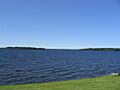
Oneida Lake borders Onondaga County to the northeast. It is the largest lake completely within New York State. This picture was taken from the town of Cicero.
-
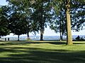
Onondaga Lake Park in the northern suburbs of Syracuse. This picture shows Onondaga Lake with the Syracuse skyline in the background. Onondaga Lake Park gets over one million visitors each year.
-
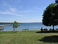
Skaneateles Lake is one of the Finger Lakes in Onondaga County.


See also
 In Spanish: Condado de Onondaga para niños
