Westvale, New York facts for kids
Quick facts for kids
Westvale, New York
|
|
|---|---|

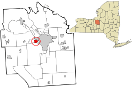
Location in Onondaga County and the state of New York.
|
|
| Country | United States |
| State | New York |
| County | Onondaga |
| Area | |
| • Total | 1.35 sq mi (3.49 km2) |
| • Land | 1.35 sq mi (3.49 km2) |
| • Water | 0.00 sq mi (0.00 km2) |
| Elevation | 505 ft (154 m) |
| Population
(2020)
|
|
| • Total | 5,090 |
| • Density | 3,773.17/sq mi (1,457.13/km2) |
| Time zone | UTC-5 (Eastern (EST)) |
| • Summer (DST) | UTC-4 (EDT) |
| ZIP code |
13219
|
| Area code(s) | 315 |
| FIPS code | 36-81127 |
| GNIS feature ID | 0970945 |
Westvale is a community in Onondaga County, New York, United States. It is a special kind of community called a census-designated place, which means it has clear borders for counting people. In 2020, about 5,090 people lived there.
Westvale is part of the town of Geddes. It is located east of Fairmount and southwest of Solvay. Westvale is also a suburb of Syracuse, which is a larger city to its east. A suburb is a residential area found just outside a city.
Contents
Geography of Westvale
Westvale is located at coordinates 43°2′30″N 76°13′1″W / 43.04167°N 76.21694°W. This helps people find it on a map.
The United States Census Bureau says that Westvale covers a total area of about 1.4 square miles (3.49 square kilometers). All of this area is land, meaning there are no large lakes or rivers within its borders.
People and Population
Westvale is home to a diverse group of people. Here's a look at the population numbers over time:
| Historical population | |||
|---|---|---|---|
| Census | Pop. | %± | |
| 2020 | 5,090 | — | |
| U.S. Decennial Census | |||
In the year 2000, there were 5,166 people living in Westvale. These people lived in 2,061 households, and 1,506 of these were families. The community had about 3,833 people per square mile.
Who Lives in Westvale
Most people in Westvale are White, making up about 97.87% of the population in 2000. Other groups include African American, Native American, and Asian residents. About 1.06% of the population identified as Hispanic or Latino.
Households and Families
Out of all the households in 2000, about 30.9% had children under 18 living there. Many households (60.0%) were married couples living together. About 10.8% had a female head of household without a husband present. The average household had 2.50 people, and the average family had 2.98 people.
Age Groups
The population in Westvale is spread across different age groups. In 2000:
- 24.3% were under 18 years old.
- 4.5% were between 18 and 24 years old.
- 22.7% were between 25 and 44 years old.
- 26.5% were between 45 and 64 years old.
- 22.0% were 65 years old or older.
The average age of people in Westvale was 44 years.
Income and Economy
In 2000, the average income for a household in Westvale was $54,870 per year. For families, the average income was $62,071. The average income per person in Westvale was $23,678. A small number of families (4.5%) and individuals (6.0%) lived below the poverty line. This included 9.7% of those under 18 and 7.8% of those 65 or older.
History of Westvale
The name "Westvale" likely came about in the early 1900s. It refers to the area west of the Wescott Reservoir. This area was mostly south of West Genesee Street. Further west was Fairmount, which developed earlier than Westvale.
Early Land and Development
A large part of Westvale was once farmland owned by the Schuyler family, a major landowning family in New York State. Parsons Drive, a main street with a grassy middle, is named after a branch of this family.
Some houses in Westvale are older than the main suburban development. The Parsons family farmhouse was replaced by new buildings in the late 1900s. West Genesee Street still has some homes from the late 1800s. Many houses built in the early 1900s show styles from the 1920s and 1930s. After World War II, Westvale grew quickly, and most houses there today were built in the later 20th century.
Shopping and Community
Westvale Plaza was one of the first suburban shopping centers in the area. It opened shortly after World War II. Today, it is a "strip mall" with stores in a row. Another shopping center, Fairmount Fair, opened later just west of Westvale. It became the first indoor, climate-controlled shopping mall in Central New York around 1967.
The Westvale-Avery Club, a men's group, worked to keep the area of West Genesee Street between the Avery Tract and Fairmount free from commercial buildings.
Schools in Westvale
Westvale was once part of the Solvay school district. Cherry Road School taught students from kindergarten to 8th grade. After that, students walked to Solvay High School. However, since 1962, Westvale has been served by the Westhill Central School District.
See also
 In Spanish: Westvale para niños
 | Anna J. Cooper |
 | Mary McLeod Bethune |
 | Lillie Mae Bradford |

