Onondaga, New York facts for kids
Quick facts for kids
Onondaga, New York
|
|
|---|---|
|
Town
|
|

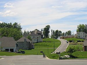
An upscale neighborhood in the hills of Onondaga just outside Syracuse
|
|

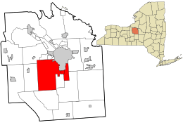
Location in Onondaga County and the state of New York.
|
|
| Country | United States |
| State | New York |
| County | Onondaga |
| Government | |
| • Type | Town Board |
| Area
Town of Onondaga
|
|
| • Total | 65 sq mi (149.80 km2) |
| • Land | 65 sq mi (149.55 km2) |
| • Water | 0.10 sq mi (0.25 km2) |
| Elevation | 1,033 ft (315 m) |
| Population
(2020)
|
|
| • Total | 22,937 |
| • Density | 352.9/sq mi (153.117/km2) |
| Time zone | UTC-5 (Eastern (EST)) |
| • Summer (DST) | UTC-4 (EDT) |
| ZIP code |
13215
|
| Area code(s) | 315 |
| FIPS code | 36-54958 |
| GNIS feature ID | 0979311 |
Onondaga is a town in Onondaga County, New York, United States. It covers about 65 square miles. In 2020, about 22,937 people lived there. The town is named after the native Onondaga tribe, who were part of the powerful Iroquois Confederacy. Onondaga became an official town on April 2, 1798. It is located southwest of the city of Syracuse, which it borders. The smaller communities that make up the town include Cedarvale, Howlett Hill, Navarino, Nedrow, Onondaga Hill, Sentinel Heights, South Onondaga, Southwood, Split Rock, and Taunton.
History of Onondaga
Native Americans have lived in the Onondaga region for hundreds of years. Around the year 1600, a village called Onondaga was the main village and capital of the Iroquois League. It was also the main home of the Onondaga people.
During the American Revolutionary War, the Onondaga people supported the British. Because of this, the American army, called the Continental Army, attacked Onondaga on April 21, 1779. After the war, the Onondagas had to give up most of their land in New York to the new state. However, some land was set aside to create the Onondaga Reservation. Many Onondaga people moved away from New York and settled in a place called Upper Canada (which is now part of Canada).
After the war, the government gave land in the Onondaga region to soldiers who had fought in the war. This area was known as the Central New York Military Tract. Many people from New England and eastern New York moved to this area. The Town of Onondaga officially became a town on April 2, 1798. Its borders have changed a few times since then. When Onondaga County was created in 1794, the town was formed from parts of other towns like Marcellus, Pompey, and Manlius.
The first courthouse for Onondaga County was built in 1805 in Onondaga Hill. At that time, Onondaga Hill was the county seat, which means it was the main government center for the county. The building was designed by an engineer named James Geddes. In 1830, the county seat moved to Syracuse. After that, the old courthouse in Onondaga Hill was used as a school until 1846.
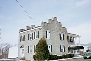
Today, the Gen. Orrin Hutchinson House is the only place in the Town of Onondaga that is listed on the National Register of Historic Places. This means it's a very important historical site. It is now a restaurant called the Inn of the Seasons.
Geography and Roads
The Town of Onondaga covers about 57.8 square miles, with most of it being land and a small part being water.
Several important roads pass through or near the town. Interstate 81 runs along the eastern side of Onondaga. U.S. Route 11 is another major road that goes north and south in the eastern part of the town, running next to Interstate 81. U.S. Route 20 is a road that goes east and west in the southern part of the town. Other state roads like New York State Route 173, New York State Route 11A, and New York State Route 80 also help people travel through Onondaga.
Population Information
| Historical population | |||
|---|---|---|---|
| Census | Pop. | %± | |
| 1820 | 5,552 | — | |
| 1830 | 5,668 | 2.1% | |
| 1840 | 5,658 | −0.2% | |
| 1850 | 5,694 | 0.6% | |
| 1860 | 5,113 | −10.2% | |
| 1870 | 5,530 | 8.2% | |
| 1880 | 6,358 | 15.0% | |
| 1890 | 5,135 | −19.2% | |
| 1900 | 5,264 | 2.5% | |
| 1910 | 5,963 | 13.3% | |
| 1920 | 6,620 | 11.0% | |
| 1930 | 5,826 | −12.0% | |
| 1940 | 6,905 | 18.5% | |
| 1950 | 9,351 | 35.4% | |
| 1960 | 13,429 | 43.6% | |
| 1970 | 16,555 | 23.3% | |
| 1980 | 17,824 | 7.7% | |
| 1990 | 18,396 | 3.2% | |
| 2000 | 21,063 | 14.5% | |
| 2010 | 23,101 | 9.7% | |
| 2020 | 22,937 | −0.7% | |
| U.S. Decennial Census | |||
According to the 2020 census, about 22,937 people live in Onondaga. There were about 7,679 households in the town. A household is a group of people living together in one home.
The population is spread out in terms of age. About 26.5% of the people are under 18 years old. About 17.2% are 65 years old or older. The average age in the town is 40 years.
See also
 In Spanish: Onondaga (Nueva York) para niños
 | Emma Amos |
 | Edward Mitchell Bannister |
 | Larry D. Alexander |
 | Ernie Barnes |


