Central New York Military Tract facts for kids
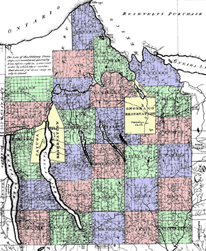
The Military Tract of Central New York was a huge area of land in Central New York. It was set aside to reward soldiers from New York who fought in the American Revolutionary War. This land was given to them as a 'bounty' for their service. It covered about 2 million acres (8,100 square kilometers).
Contents
Why Was the Military Tract Created?
Before the war ended, New York had promised its soldiers land. Each soldier was supposed to get at least 100 acres (0.4 square kilometers). But by 1781, New York needed more soldiers. So, they offered a bigger reward.
The government decided to give each soldier an extra 500 acres (2.0 square kilometers). This land came from 25 new areas called 'Townships' in central New York. Each township was planned to have 100 lots, with each lot being 600 acres (2.4 square kilometers). Later, three more townships were added: Junius, Galen, and Sterling. The United States Congress approved this plan in 1789. It became official in 1799.
What Were the Townships Called?
At first, the townships were just numbered from 1 to 28. But later, they were given names. Most of these names came from ancient Greek and Roman history. Some were named after famous people like the Carthaginian general Hannibal. A few also honored English writers.
The names for these townships are often credited to Robert Harpur. He worked for New York's Surveyor General, Simeon De Witt.
Where Was the Military Tract?
The Military Tract covered parts of several modern counties in New York. These include Cayuga, Cortland, Onondaga, and Seneca. It also included parts of Oswego, Tompkins, Schuyler, and Wayne.
Many of the current towns in these counties still have names from the original townships. However, the exact borders of the old military townships are not the same as today's towns.
Each township was designed to be a 10x10 square of mile-square lots. A mile-square lot is about 640 acres (2.6 square kilometers). About 40 acres (16 hectares) were used for roads. This left 600 acres (2.4 square kilometers) for each land deed. Most of the lots (94 out of 100) were given to soldiers. The other six lots in each township were set aside for public uses, like churches and schools.
Two Indian reservations were also part of the Military Tract. These were for the Onondaga and Cayuga Native American nations. Later, New York State took much of this land through treaties.
Important Dates for the Military Tract
- June 18, 1779: The Sullivan Expedition began. During this time, many Native American villages were destroyed. Winter crops were also ruined. Many people from the Haudenosaunee nation had to leave their homes and flee to Canada.
- March 20, 1781: New York's government officially allowed the creation of the Military Tract. This was part of their plan to get more soldiers for the war.
- October 19, 1781: The Revolutionary War ended when Cornwallis surrendered.
- July 25, 1782: New York's government set the approximate borders for the first 25 townships.
- September 3, 1783: The Treaty of Paris was signed, officially ending the war with Great Britain.
- September 12, 1788: The Treaty of Fort Stanwix was signed. This agreement created the Onondaga Indian Reservation.
- February 25, 1789: The Treaty at Albany was signed. This agreement created the Cayuga Indian Reservation.
- 1789: The Military Tract was surveyed, meaning the land was measured and mapped.
- July 3, 1790: The first 25 townships were given their classical names. This was done by the Commissioners of the Land Office of New York.
- 1791: The land lots were officially given to the soldiers.
- 1791: Township 26 was named Junius.
- 1792: Township 27 was named Galen.
- 1795: Township 28 was named Sterling.
- 1799: This was the deadline for soldiers to claim and settle on their land.
 | Victor J. Glover |
 | Yvonne Cagle |
 | Jeanette Epps |
 | Bernard A. Harris Jr. |


