
Wayne County, New York facts for kids
Quick facts for kids
Wayne County
|
|||
|---|---|---|---|

Wayne County Courthouse in Lyons
|
|||
|
|||

Location within the U.S. state of New York
|
|||
 New York's location within the U.S. |
|||
| Country | |||
| State | |||
| Founded | 1823 | ||
| Named for | Anthony Wayne | ||
| Seat | Lyons | ||
| Largest town | Arcadia | ||
| Area | |||
| • Total | 1,383 sq mi (3,580 km2) | ||
| • Land | 604 sq mi (1,560 km2) | ||
| • Water | 779 sq mi (2,020 km2) 56% | ||
| Population
(2020)
|
|||
| • Total | |||
| • Density | 151/sq mi (58/km2) | ||
| Time zone | UTC−5 (Eastern) | ||
| • Summer (DST) | UTC−4 (EDT) | ||
| Congressional district | 24th | ||


Wayne County is a county in New York. In 2020, about 91,283 people lived here. The main town and county seat is Lyons. The county is named after General Anthony Wayne. He was a hero from the American Revolutionary War. Wayne County is part of the beautiful Finger Lakes region.
This county is less than 50 miles west of Syracuse. It's also near Rochester. Wayne County sits on the south shore of Lake Ontario. This lake forms part of the border between the United States and Canada.
Because of its location, Wayne County has a rich history. It was important during the early days of America's expansion west. It's also a very fertile farming area. Two major religions started here. People from Wayne County also helped fight against slavery before the American Civil War. Today, it's known as one of the best places in the world for growing fruit. Wayne County grows more apples than any other county in New York.
Contents
History of Wayne County
Long ago, before Europeans came, this land was part of the Iroquois Confederacy. This group of Native American nations had been here for a very long time. When New York State first created counties in 1683, this area was part of Albany County.
On April 11, 1823, Wayne County was officially formed. It was made from parts of Seneca and Ontario counties.

Early Settlers and Land Deals
The first European settlers came to the area around the Ganargua River. This was just west of where Palmyra is today. In 1788, the land became part of the Phelps and Gorham Purchase. This was a huge piece of land sold to Oliver Phelps and Nathaniel Gorham. Later, in 1790, a British land investor named Sir William Pulteney bought a large part of this land.
The first main road for westward travelers went through other areas. This left the future Wayne County a bit isolated. Settlers had to come by streams and lakes. But soon, a "new road" was built. This road passed through the county. It made it much easier for people to settle in the fertile Ganargua lands.
The first lasting settlement was started in March 1789. John Swift and Col. John Jenkins began it near Palmyra. In May of that year, the Stansell and Featherly families settled at the junction of the Ganargwa and Canandaigua Outlet. They called the place Lyons.
Sir William Pulteney hired Charles Williamson to manage his land. In 1792, Williamson came to New York. He worked to develop the land. He built roads, chose spots for towns, and set up mills and stores. Williamson thought Sodus Bay on Lake Ontario would be a great trade center. He believed the lake and the Saint Lawrence River could be used to ship goods. By 1794, roads were built from Palmyra to Phelps. Sodus quickly grew into an important town.
War of 1812 Skirmishes
Wayne County saw two small fights during the War of 1812. One happened in Sodus in June 1813. The other was in Williamson a year later. In May 1814, British soldiers landed in Pultneyville. They wanted to take supplies. At first, they agreed not to fight if they could take what they needed. But a disagreement started, and fighting broke out. Some citizens were killed or hurt, and two were captured before the British left.
Great Lakes Trade
Before the Erie Canal opened in 1823, Pultneyville, New York was Wayne County's only port. From about 1811 to the 1890s, ships from this small town could reach the Atlantic Ocean. They sailed through the Saint Lawrence River. Pultneyville was a busy place for farming trade and shipping on the Great Lakes. In 1865, almost 30 lake captains lived there. Many sailors from Pultneyville and Sodus Bay worked on whaling ships around the world. When the first railroad came in 1874, trade moved to Williamson. Pultneyville's importance as a trade center then declined a lot.
Religion and New Movements
Wayne County was a key place for new religious movements in the early 1800s. This time was called the Second Great Awakening.

- Spiritualism and the Fox Sisters: On March 31, 1848, Kate and Margaret Fox from Hydesville said they heard rapping noises. They believed these sounds came from the spirit of a murdered peddler. This was a big deal because the spirit communicated through sounds, not just visions. The Fox sisters became very famous. People loved seeing demonstrations of talking to spirits. This became a popular form of entertainment and spiritual comfort.
- Latter-day Saints (Mormons): Palmyra is where the Latter Day Saint movement began in the 1820s. The founder, Joseph Smith, lived on a farm nearby. He said that God the Father and Jesus Christ visited him in 1820. This event is known as the First Vision. In 1830, the Book of Mormon was first published in the village of Palmyra.
- Shakers in Wayne County: Sodus Bay was home to a community of Shakers from 1826 to 1836. This location was good for traveling by water to visit other Shakers. It might also have helped abolitionists move former slaves to freedom in Canada. The Shakers had 72 new members in their first year. By 1835, their community grew to almost 150 people. However, they learned that a canal was planned to go through their land. New York state law allowed the canal company to take their property. So, the Shakers sold their land and buildings. They moved to a new place in Livingston County, New York. The canal was never built, but the Shakers had already settled elsewhere.
Civil War and the Underground Railroad

During the American Civil War, people in Wayne County actively supported the Underground Railroad. This was a secret network that helped enslaved people escape to freedom in Canada. Wayne County also sent many soldiers to fight for the Union army. These included the 33rd, 98th, and 111th New York Volunteer Infantry Regiments.
Men from Wayne County served in the 111th New York Infantry. This regiment fought in major battles like Battle of Gettysburg, Battle of the Wilderness, and Battle of Cold Harbor. At Gettysburg, the 111th had the second-highest number of casualties of any regiment in the entire battle. They lost many soldiers throughout the war.
Erie Canal's Impact
The Erie Canal runs along the southern edge of Wayne County. When the canal section from Albany to Rochester opened on September 10, 1823, several villages became important. These included Clyde, Lyons, Newark, Palmyra, and Macedon. They all had canal locks. This meant they were directly connected by water to big cities like New York City. They also connected to America's growing western frontier.
Nuclear Power Plant
On June 1, 1970, the Robert E. Ginna Nuclear Power Plant began operating. It is located on the shore of Lake Ontario in the Town of Ontario.
In 1982, a small amount of steam with very low levels of radiation leaked from the plant. This leak lasted for about 93 minutes. It was caused by a small object left inside a steam generator. No one was seriously harmed, but the event brought a lot of attention to the plant.
Local Historical Societies
Wayne County has many groups dedicated to preserving its history. Besides the main county historical society, many towns and villages have their own.
|
Geography of Wayne County
Wayne County covers about 1,383 square miles. About 604 square miles are land, and 779 square miles (56%) are water.
The county is in western New York State. It is east of Rochester and northwest of Syracuse. It lies on the south shore of Lake Ontario. Sodus Bay is a large bay on the county's northern shoreline. Wayne County borders Cayuga County to the east. It borders Ontario and Seneca counties to the south. To the west is Monroe County.
A band of red iron ore, called the Clinton Formation, runs across the county. This led to a busy iron industry in the 1800s. Iron furnaces were located in the Towns of Ontario and Wolcott.
Wayne County is part of a larger natural area called the Eastern Great Lakes and Hudson Lowlands. This region was shaped by glaciers during the last ice age. It has many hills and valleys formed by the ice.
Neighboring Counties
- Cayuga County – to the east
- Seneca County – to the southeast
- Ontario County – to the south
- Monroe County – to the west
Main Roads
 New York State Route 14
 New York State Route 21
 New York State Route 31
 New York State Route 31F
 New York State Route 88
 New York State Route 89
 New York State Route 104
 New York State Route 104A
 New York State Route 286
 New York State Route 350
 New York State Route 370
 New York State Route 414
 New York State Route 441
Protected Natural Areas
- Lake Ontario National Marine Sanctuary (part)
- Montezuma National Wildlife Refuge (part)
People of Wayne County
| Historical population | |||
|---|---|---|---|
| Census | Pop. | %± | |
| 1830 | 33,643 | — | |
| 1840 | 42,057 | 25.0% | |
| 1850 | 44,953 | 6.9% | |
| 1860 | 47,762 | 6.2% | |
| 1870 | 47,710 | −0.1% | |
| 1880 | 51,700 | 8.4% | |
| 1890 | 49,729 | −3.8% | |
| 1900 | 48,660 | −2.1% | |
| 1910 | 50,179 | 3.1% | |
| 1920 | 48,827 | −2.7% | |
| 1930 | 49,995 | 2.4% | |
| 1940 | 52,747 | 5.5% | |
| 1950 | 57,323 | 8.7% | |
| 1960 | 67,989 | 18.6% | |
| 1970 | 79,404 | 16.8% | |
| 1980 | 84,581 | 6.5% | |
| 1990 | 89,123 | 5.4% | |
| 2000 | 93,765 | 5.2% | |
| 2010 | 93,751 | 0.0% | |
| 2020 | 91,283 | −2.6% | |
| U.S. Decennial Census 1790-1960 1900-1990 1990-2000 2010-2020 |
|||
In 2020, the population of Wayne County was 91,283. Most people (86.8%) were White. About 2.63% were Black or African American. About 5% of the population was Hispanic or Latino.
In 2010, there were 93,772 people living in the county. About 29.5% of households had children under 18. Most households (53%) were married couples. The average household had 2.53 people. The average family had 2.99 people.
The median age in the county was 41.6 years. This means half the people were younger than 41.6 and half were older. About 26.2% of the population was under 20 years old.
The average income for a household was $52,601. For a family, it was $62,677. About 11.3% of the population lived below the poverty line. This included 16.4% of those under 18.
Economy of Wayne County
Wayne County has over 150 manufacturing companies. Some of these are very large companies. They choose Wayne County because it's easy to get goods to market. It also has good transportation and a skilled workforce. Many colleges and universities are nearby, like the University of Rochester and Syracuse University.
Wayne County is part of the Finger Lakes region. This region exports about $16 billion worth of goods each year. In 2007, the Finger Lakes region made $1.2 billion from farming. Wayne County was the top producer of fruits, tree nuts, and berries in New York. It was also the top producer of apples in the state. In fact, it ranked third in the nation for apple production in 2007!
Here are some quick facts about businesses in Wayne County:
- In 2021, there were 1,676 businesses that had employees.
- These businesses employed 19,136 people in 2021.
- In 2017, there were 1,494 businesses with employees.
- Total retail sales in 2017 were about $997 million.
Education in Wayne County
Wayne County does not have one big school district. Instead, it has several smaller school districts for students from kindergarten to 12th grade. Each district has its own elected school board and superintendent. They get money from local property taxes and state/federal aid. These districts include:
- Palmyra-Macedon Central School District
- Wayne Central School District
- Gananda Central School District
- Newark Central School District
- Marion Central School District
- Williamson Central School District
- Lyons Central School District
- North Rose-Wolcott Central School District
- Red Creek Central School District
- Sodus Central School District
- Clyde-Savannah Central School District
All schools in New York State follow rules from the New York State Board of Regents. Wayne County's school districts also work together through the Wayne Finger Lakes Board of Cooperative Educational Services (BOCES). This organization helps share educational resources.
Wayne County also has some private and religious schools. These include East Palmyra Christian School and Heritage Baptist Christian School. While there are no four-year colleges directly in Wayne County, there is a campus of Finger Lakes Community College in Newark. This college offers two-year degrees. Many other great colleges and universities are in nearby counties.
Culture and Events
Wayne County hosts many festivals and parades. Most of these happen from late spring to early fall because of the weather. Some popular events include:
- Apple Blossom Festival (Williamson, third week in May)
- Peppermint Days (Lyons, second weekend in July)
- Rose Parade (Newark, third weekend in July)
- Pultneyville Homecoming Festivities (Pultneyville, third weekend in July)
- CNY Wine & Jazz Festival (Wolcott, first Saturday in August)
- Palmyra Pirate Weekend (Palmyra, second weekend in August)
- Wayne County Fair (Palmyra, second week in August)
- Lumberjack Festival (Macedon Center, second weekend in September)
- Canaltown Days (Palmyra, third weekend in September)
- Savannah's Potato Festival (Savannah, third weekend in September)
Many of Wayne County's volunteer fire departments also host "firemen's carnivals" in the summer. These events have parades, rides, food, and fireworks. They are a big part of summer fun in the community.
Communities in Wayne County
Wayne County does not have any large cities. It has 15 towns and seven villages.
Largest Settlements (Villages and Census-Designated Places)
| # | Location | Population | Type | Area |
|---|---|---|---|---|
| 1 | Newark | 9,145 | Village | West |
| 2 | ‡Lyons | 3,619 | CDP | East |
| 3 | Palmyra | 3,536 | Village | West |
| 4 | Williamson | 2,495 | CDP | Lake Shore |
| 5 | Ontario | 2,160 | CDP | Lake Shore |
| 6 | Clyde | 2,093 | Village | East |
| 7 | Sodus | 1,819 | Village | Lake Shore |
| 8 | Wolcott | 1,701 | Village | Lake Shore |
| 9 | †Macedon | 1,523 | CDP | West |
| 10 | Marion | 1,511 | CDP | West |
| 11 | Sodus Point | 900 | Village | Lake Shore |
| 12 | Pultneyville | 698 | CDP | Lake Shore |
| 13 | North Rose | 636 | CDP | East |
| 14 | †Savannah | 558 | CDP | East |
| 15 | Red Creek | 532 | Village | Lake Shore |
Towns in Wayne County
Images for kids
-
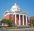
Wayne County Courthouse in Lyons
-
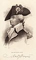
"Mad Anthony" Wayne
-
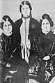
Kate and Margaret Fox
-
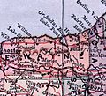
Wayne County detail of 1885 atlas
See also
 In Spanish: Condado de Wayne (Nueva York) para niños
