Clyde, New York facts for kids
Quick facts for kids
Clyde, New York
|
|
|---|---|
|
Village
|
|

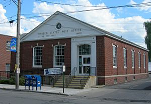
The Clyde Post Office
|
|

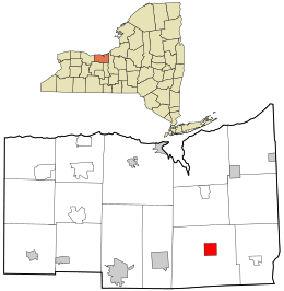
Location in Wayne County and the state of New York.
|
|
| Country | United States |
| State | New York |
| County | Wayne |
| Town | Galen |
| Settled | 1811 |
| Incorporated | May 2, 1835 |
| Named for | River Clyde |
| Government | |
| • Type | Board of Trustees |
| Area | |
| • Total | 2.26 sq mi (5.85 km2) |
| • Land | 2.20 sq mi (5.69 km2) |
| • Water | 0.06 sq mi (0.15 km2) |
| Elevation | 400 ft (122 m) |
| Population
(2020)
|
|
| • Total | 2,171 |
| • Density | 987.72/sq mi (381.33/km2) |
| Time zone | UTC-5 (Eastern (EST)) |
| • Summer (DST) | UTC-4 (EDT) |
| ZIP code |
14433
|
| Area code(s) | 315 |
| FIPS code | 36-16573 |
| GNIS feature ID | 0946941 |
| Website | http://www.clydeny.com |
Clyde is a small village in Wayne County, New York, United States. In 2010, about 2,093 people lived there. The village is named after the River Clyde in Scotland. It is also located right on the Clyde River, which flows into the Seneca River.
Clyde is part of the Town of Galen. It is located northeast of Geneva, New York. The village is roughly halfway between the larger cities of Rochester and Syracuse.
Contents
A Look Back: Clyde's History
Long ago, even before the French and Indian War, there was a French trading post and a small fort (called a blockhouse) where Clyde is today. During the American Revolution, this spot was known for smuggling goods. People even called it "the Blockhouse" because of its past.
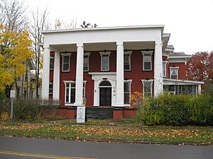
Two important buildings in Clyde are listed on the National Register of Historic Places. These are the Smith-Ely Mansion and the U.S. Post Office. They are protected because of their historical importance.
Clyde's Role in the Civil War
During the American Civil War, many brave men from Clyde joined the fight. They were part of Company B in the 111th New York Volunteer Infantry regiment. This group fought in many major battles. These included the famous Battle of Gettysburg, the tough Battle of the Wilderness, and the intense Battle of Cold Harbor. They also took part in the final Appomattox Campaign.
The 111th New York regiment faced very difficult conditions. At the Battle of Gettysburg, they had the second-highest number of casualties of any regiment in the entire battle. This shows how bravely they fought.
The Erie Canal's Connection
Clyde is also a part of the Erie Canalway National Heritage Corridor. This means it's connected to the famous Erie Canal. The canal was a very important waterway that helped transport goods and people across New York.
Exploring Clyde: Geography and Location
Clyde is located at coordinates 43 degrees 5 minutes 3 seconds North and 76 degrees 52 minutes 13 seconds West.
The village covers a total area of about 2.3 square miles (5.85 square kilometers). Most of this area, about 2.2 square miles (5.69 square kilometers), is land. A small part, about 0.1 square miles (0.15 square kilometers), is water.
Clyde is known as an Erie Canal village. The Clyde River itself became part of the canal system. The path of the canal through the village was even changed during updates to the canal.
You can find Clyde where two important state roads meet: Route 31 and Route 414.
Who Lives in Clyde? Population Facts
| Historical population | |||
|---|---|---|---|
| Census | Pop. | %± | |
| 1870 | 2,735 | — | |
| 1880 | 2,826 | 3.3% | |
| 1890 | 2,638 | −6.7% | |
| 1900 | 2,507 | −5.0% | |
| 1910 | 2,695 | 7.5% | |
| 1920 | 2,528 | −6.2% | |
| 1930 | 2,374 | −6.1% | |
| 1940 | 2,356 | −0.8% | |
| 1950 | 2,492 | 5.8% | |
| 1960 | 2,693 | 8.1% | |
| 1970 | 2,828 | 5.0% | |
| 1980 | 2,491 | −11.9% | |
| 1990 | 2,409 | −3.3% | |
| 2000 | 2,269 | −5.8% | |
| 2010 | 2,093 | −7.8% | |
| 2020 | 2,171 | 3.7% | |
| U.S. Decennial Census | |||
In 2010, the village of Clyde had 2,093 people living there. There were 798 households and 545 families. The population density was about 951 people per square mile (367 people per square kilometer).
Most of the people in Clyde, about 90.2%, were White. About 4.5% were Black or African American. Smaller groups included Native American (0.2%) and Asian (0.5%). About 4.0% of the population identified as Hispanic or Latino.
About 31.2% of households had children under 18 living with them. The average household had 2.61 people. The average family had 3.10 people.
The population was spread out by age. About 30.1% were under 20 years old. About 13.9% were 65 years or older. The average age in the village was 37.1 years.
See also
 In Spanish: Clyde (Nueva York) para niños
 | Stephanie Wilson |
 | Charles Bolden |
 | Ronald McNair |
 | Frederick D. Gregory |


