Seneca River (New York) facts for kids
The Seneca River flows for about 61.6 miles (99.1 km) through the beautiful Finger Lakes area of Upstate New York in the United States. It's a very important river because it's the main branch of the Oswego River, which is the second-largest river that flows into Lake Ontario. The Seneca River helps drain a huge area of 3,468 square miles (8,980 km2) across fourteen counties in New York. The river generally flows east, and it's wide, deep, and moves slowly. A big part of the river has been changed to become part of the famous Erie Canal.
Quick facts for kids Seneca River |
|
|---|---|

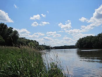
Seneca River above Bonta Bridge in Jordan
|
|

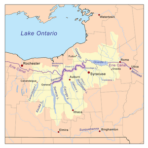
Map of the Oswego River basin with the Seneca River highlighted
|
|
| Country | United States |
| State | New York |
| Physical characteristics | |
| Main source | Seneca Lake Geneva, Seneca County 443 ft (135 m) 42°52′05″N 76°56′27″W / 42.86806°N 76.94083°W |
| River mouth | Oswego River Three Rivers, Onondaga County 358 ft (109 m) 43°12′05″N 76°16′51″W / 43.20139°N 76.28083°W |
| Length | 61.6 mi (99.1 km) |
| Basin features | |
| Basin size | 3,468 sq mi (8,980 km2) |
| Tributaries |
|
Contents
River's Journey: Where Does the Seneca River Flow?
The Seneca River starts its journey in Geneva, in Seneca County. It flows out of Seneca Lake and heads east, passing by towns like Waterloo and Seneca Falls.
As it continues, the river goes around the northern part of Cayuga Lake near the Montezuma Marsh. Here, it turns north and is joined by the Clyde River from the west. The Seneca River then forms the border between Seneca and Cayuga counties, and then between Cayuga and Wayne counties.
The river flows under Interstate 90 and moves northeast past Weedsport. It crosses the middle of Cayuga County before flowing into Cross Lake.
After Cross Lake, the Seneca River enters Onondaga County. It makes a sharp turn north, then east, passing through Baldwinsville and Liverpool. It flows along the northern edge of the Syracuse area, where it receives water from Onondaga Lake.
Finally, the river flows north to meet the Oneida River at a place called Three Rivers. This meeting point is on the border of Onondaga and Oswego County. When the Seneca and Oneida rivers join, they form the Oswego River. From there, the Oswego River flows another 23 miles (37 km) north and empties into Lake Ontario at the city of Oswego.
River's Network: Understanding the Watershed
The Seneca River's watershed is the entire area of land where all the rain and snowmelt eventually drain into the river. This watershed covers a total of 3,468 square miles (8,980 km2). This is about two-thirds of the larger Oswego River basin.
There are about 4,370 miles (7,030 km) of smaller streams and rivers within the Seneca River's watershed. The Seneca River receives water from seven of the eleven famous Finger Lakes. These lakes are Canandaigua, Keuka, Seneca, Cayuga, Owasco, Skaneateles, and Otisco.
Water from Canandaigua Lake flows into the Seneca River through the Canandaigua Outlet and the Clyde River. Keuka Lake empties into Seneca Lake through the Keuka Lake Outlet. Owasco and Skaneateles Lakes join the Seneca through their own outlet streams. Otisco Lake flows into Onondaga Lake via Ninemile Creek, and Onondaga Lake then empties into the Seneca River.
Smaller Rivers and Streams: Tributaries of the Seneca River
Many smaller rivers and streams flow into the Seneca River. These are called tributaries.
Tributaries from the Left Side
Tributaries from the Right Side
- Kendig Creek
- Silver Creek
- Sucker Brook
- Sampson Creek
- Demont Creek
- Cayuga Lake
- Crane Brook
- Owasco River
- Skaneateles Creek
- Dead Creek
- Crooked Brook
- Onondaga Lake
History of the Seneca River
The Seneca River has a long and interesting history, especially with the people who lived here first and how the river was changed for travel and industry.
Native American History
The river is named after the Seneca people, who were a Native American group whose lands stretched between Lake Erie and Seneca Lake. The Onondaga lived around Onondaga Lake and Syracuse, and the Cayuga lived along the river valley and lake shores in between. All three groups were part of the Iroquois League, a powerful alliance that formed hundreds of years ago. For a very long time before Europeans arrived, the Seneca River was a vital route for trade among these Native American groups.
Early Explorers and Settlers
The first Europeans to explore the Seneca River were likely Jesuit missionaries in the late 1600s. They set up a small outpost called St. Stephen near where the river starts at Seneca Lake. Later, more settlers arrived and began to build towns and use the river's power.
Building Canals: Changing the River for Travel
In 1821, a company finished building eight locks on the upper Seneca River. Locks are like water elevators that help boats move up or down different water levels. These locks allowed boats to travel from Cayuga Lake to Seneca Lake. By 1828, the state took over and created the Cayuga–Seneca Canal, which has eleven locks along its 21 miles (34 km) length.
Work on the Seneca part of the Erie Canal began in the 1820s. The river's channel between Three Rivers and Cayuga Lake was made wider and straighter so that large barges could use it. In some places, new canals were built next to the river to bypass difficult sections. The canal sometimes had to cross the Seneca River. To do this, locks were built to lower boats to the river's level, where they were then pulled across with the help of temporary wooden bridges. In 1849, work started to separate the canal from the river to prevent problems from flooding and sedimentation (when dirt and sand settle at the bottom).
The Montezuma Marshes, located where Cayuga Lake flows out, were a big challenge for building the Erie Canal. A large stone bridge, called the Seneca River Aqueduct (or Richmond Aqueduct), was built to carry the canal over the Seneca and Clyde Rivers. It opened in 1857 after eight years of building. At 840 feet (260 m) long, it was the second-longest aqueduct on the entire Erie Canal system. Most of this aqueduct was later taken down in the 1910s to make way for the Barge Canal, a newer and larger canal system.
Certain spots along the Seneca River became important places for industry early on. Seneca Falls was special because it had the only natural drop in the river's elevation, which was perfect for powering water mills. In other places where there were no natural waterfalls, people built dams to create power for mills, like in Baldwinsville. In 1915, a large dam 80 feet (24 m) high was built at Seneca Falls to create hydroelectricity, which is electricity made from the power of moving water.
River Health: Ecology and Environmental Concerns
The Seneca River, especially below Onondaga Lake, has faced some environmental challenges. It has been affected by waste from industries and homes. This includes higher levels of certain chemicals like mercury, PCBs, dioxin, and ammonia. Because of this, the New York State Department of Health suggests that people limit how much fish they eat from the lower part of the river.
Parts of the river are also home to zebra mussels, which are not native to the area. These mussels can cause problems by using up the oxygen in the water, which can harm fish populations. In one specific part of the river below Cross Lake, the number of these mussels is considered to be one of the highest in North America.
 | Aaron Henry |
 | T. R. M. Howard |
 | Jesse Jackson |

