Cayuga County, New York facts for kids
Quick facts for kids
Cayuga County
|
|||
|---|---|---|---|

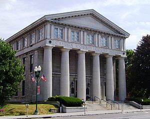
Cayuga County Courthouse
|
|||
|
|||

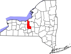
Location within the U.S. state of New York
|
|||
 New York's location within the U.S. |
|||
| Country | |||
| State | |||
| Founded | 1799 | ||
| Named for | Cayuga people | ||
| Seat | Auburn | ||
| Largest city | Auburn | ||
| Area | |||
| • Total | 864 sq mi (2,240 km2) | ||
| • Land | 692 sq mi (1,790 km2) | ||
| • Water | 172 sq mi (450 km2) 20% | ||
| Population
(2020)
|
|||
| • Total | 76,248 | ||
| • Density | 110.3/sq mi (42.6/km2) | ||
| Time zone | UTC−5 (Eastern) | ||
| • Summer (DST) | UTC−4 (EDT) | ||
| Congressional district | 24th | ||
Cayuga County is a county in the state of New York, USA. In 2020, about 76,248 people lived here. Its main city and biggest town is Auburn. The county got its name from the Cayuga people, a Native American tribe that was part of the Iroquois Confederation. Cayuga County is located in the Central New York area of the state.
Contents
History of Cayuga County
Cayuga County has a long and interesting history, starting even before it became its own county.
Early County Formations
When New York was still a British colony in 1683, the area that is now Cayuga County was part of a huge place called Albany County. This county was enormous, stretching all the way to the Pacific Ocean (at least on paper!). Over time, Albany County was made smaller as new counties were created.
In 1772, a new county called Tryon County was formed from Albany County. This new county covered a large western part of New York. It was named after William Tryon, who was the colonial governor.
Changes After the Revolutionary War
After the American Revolutionary War ended in 1784, the name of Tryon County was changed to Montgomery County. This was done to honor General Richard Montgomery, an American hero who died fighting in Canada.
As New York grew, Montgomery County also became too big. In 1789, Ontario County was created from it. Then, in 1791, Herkimer County was formed from Montgomery County.
How Cayuga County Was Formed
In 1794, Onondaga County was created by splitting off from Herkimer County.
Finally, in 1799, Cayuga County was officially formed! It was created by splitting off from Onondaga County. At first, Cayuga County was much larger than it is today. It included areas that are now Seneca County and Tompkins County.
Later, in 1804, Seneca County was formed from Cayuga County. And in 1817, Tompkins County was created using parts of both Seneca and Cayuga Counties.
New Settlers
In the late 1800s and early 1900s, many immigrants from Europe, especially Italy and Poland, came to this region. They often started new farms or took over existing ones.
Geography of Cayuga County
Cayuga County is located in the west-central part of New York State. It's part of the beautiful Finger Lakes region, known for its long, narrow lakes.
The county covers about 864 square miles. About 692 square miles of this is land, and 172 square miles (or 20%) is water.
Owasco Lake is right in the middle of the county. Cayuga Lake forms part of its western border. To the north, Lake Ontario touches the county. Skaneateles Lake and Cross Lake are part of the eastern border. Cayuga County has more waterfront land than almost any other county in New York!
Neighboring Counties
- Oswego County – northeast
- Onondaga County – east
- Cortland County – southeast
- Tompkins County – south
- Seneca County – west
- Wayne County – west
- Prince Edward County, Ontario – north
Main Roads
Protected Natural Areas
- Lake Ontario National Marine Sanctuary (part)
- Montezuma National Wildlife Refuge (part)
Population of Cayuga County
| Historical population | |||
|---|---|---|---|
| Census | Pop. | %± | |
| 1800 | 15,871 | — | |
| 1810 | 29,843 | 88.0% | |
| 1820 | 38,897 | 30.3% | |
| 1830 | 47,948 | 23.3% | |
| 1840 | 50,338 | 5.0% | |
| 1850 | 55,458 | 10.2% | |
| 1860 | 55,767 | 0.6% | |
| 1870 | 59,550 | 6.8% | |
| 1880 | 65,081 | 9.3% | |
| 1890 | 65,302 | 0.3% | |
| 1900 | 66,234 | 1.4% | |
| 1910 | 67,106 | 1.3% | |
| 1920 | 65,221 | −2.8% | |
| 1930 | 64,751 | −0.7% | |
| 1940 | 65,508 | 1.2% | |
| 1950 | 70,136 | 7.1% | |
| 1960 | 73,942 | 5.4% | |
| 1970 | 77,439 | 4.7% | |
| 1980 | 79,894 | 3.2% | |
| 1990 | 82,313 | 3.0% | |
| 2000 | 81,963 | −0.4% | |
| 2010 | 80,026 | −2.4% | |
| 2020 | 76,248 | −4.7% | |
| U.S. Decennial Census 1790–1960 1900–1990 1990–2000 2010–2020 |
|||
2020 Census Information
The table below shows the different groups of people living in Cayuga County according to the 2020 Census.
| Race | Num. | Perc. |
|---|---|---|
| White (NH) | 66,313 | 86.97% |
| Black or African American (NH) | 2,727 | 3.57% |
| Native American (NH) | 224 | 0.29% |
| Asian (NH) | 379 | 0.49% |
| Pacific Islander (NH) | 54 | 0.07% |
| Other/Mixed (NH) | 3,915 | 5.13% |
| Hispanic or Latino | 2,636 | 3.45% |
Communities in Cayuga County
Larger Towns and Villages
Here are some of the biggest towns and villages in Cayuga County:
| # | Location | Population | Type | Sector |
|---|---|---|---|---|
| 1 | †Auburn | 27,687 | City | Center |
| 2 | Melrose Park | 2,294 | CDP | Center |
| 3 | Weedsport | 1,815 | Village | North |
| 4 | Port Byron | 1,290 | Village | North |
| 5 | Moravia | 1,282 | Village | South |
| 6 | Union Springs | 1,197 | Village | Center |
| 7 | Aurora | 724 | Village | South |
| 7 | Fair Haven | 724 | Village | North |
| 9 | Cayuga | 549 | Village | Center |
| 10 | Cato | 532 | Village | North |
| 11 | Meridian | 309 | Village | North |
† - County Seat (the main administrative town)
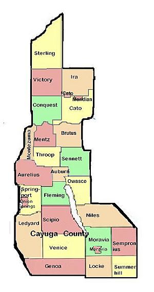
Towns
Hamlets
Notable People from Cayuga County
Many important people have connections to Cayuga County:

- Charles Bogardus (1841–1929) – A politician and businessman.
- William H. Carpenter (1821–1885) – Served as a U.S. Consul in China during the American Civil War.
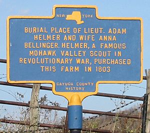
- Adam Helmer (c. 1754–1830) – A hero from the American Revolutionary War.
- William H. Seward (1801–1872) – A very important politician who was the United States Secretary of State and a Governor of New York.
- Harriet Tubman (1822–1913) – A famous abolitionist (someone who fought to end slavery) and social activist.
- Harold Wethey (1902–1984) – An art historian and professor.
See also
 In Spanish: Condado de Cayuga para niños
 | Chris Smalls |
 | Fred Hampton |
 | Ralph Abernathy |


