
Tompkins County, New York facts for kids
Quick facts for kids
Tompkins County
|
|||
|---|---|---|---|
     Images, from top down, left to right: Ithaca Falls, Johnson Museum of Art, Allan H. Treman State Marine Park, Stewart Park, Ithaca Commons, and Cornell University
|
|||
|
|||

Location within the U.S. state of New York
|
|||
 New York's location within the U.S. |
|||
| Country | |||
| State | |||
| Founded | April 17, 1817 | ||
| Named for | Daniel D. Tompkins | ||
| Seat | Ithaca | ||
| Largest City | Ithaca | ||
| Area | |||
| • Total | 492 sq mi (1,270 km2) | ||
| • Land | 475 sq mi (1,230 km2) | ||
| • Water | 17 sq mi (40 km2) 3.4% | ||
| Population
(2020)
|
|||
| • Total | 105,740 | ||
| • Density | 222.8/sq mi (86.0/km2) | ||
| Demonym(s) | Tompkins Countyan | ||
| Time zone | UTC−5 (Eastern) | ||
| • Summer (DST) | UTC−4 (EDT) | ||
| ZIP Codes |
13053, 13062, 13068, 13073, 13102, 13736, 14817, 13864, 14850, 14851, 14852, 14853, 14854, 14867, 14881, 14882, 14883, 14886
|
||
| Area code | 607 | ||
| Congressional district | 19th | ||


Tompkins County is a place in New York State. In 2020, about 105,740 people lived there. The main city, called the county seat, is Ithaca. The county is named after Daniel D. Tompkins. He was a governor of New York and later the Vice President of the United States. Tompkins County is in the 'Southern Tier' part of New York.
Tompkins County is part of the Ithaca Metropolitan Statistical Area. It's famous for its colleges! You'll find Cornell University, Ithaca College, and Tompkins Cortland Community College here.
Contents
History of Tompkins County
When counties were first set up in New York in 1683, the area that is now Tompkins County was part of a huge county called Albany County. This county was so big it even included parts of what is now Vermont.
Over many years, Albany County was split into smaller counties. In 1772, a new county called Tryon County was created. It covered a large western part of New York. After the American Revolutionary War, in 1784, Tryon County was renamed Montgomery County. This was to honor Richard Montgomery, a general who fought in the war.
More counties were formed from Montgomery County, including Herkimer County in 1791, and then Onondaga County in 1794.
In 1799, Cayuga County was formed from Onondaga County. This new Cayuga County was much larger than it is today. It included the land that would become Tompkins County. Later, in 1804, Seneca County was created from Cayuga County.
Finally, on April 7, 1817, Tompkins County was officially created. It was made from parts of Seneca County and the remaining part of Cayuga County. The county was named after Daniel Tompkins, who was the Vice President of the United States at that time.
In 1854, a small part of Tompkins County was given to the newly formed Schuyler County.
Geography of Tompkins County

Tompkins County covers about 492 square miles. Most of this area, about 475 square miles, is land. The rest, about 17 square miles, is water.
The county is located in the west-central part of New York State. It is south of Syracuse and northwest of Binghamton. Many people consider Tompkins County to be part of the beautiful Finger Lakes region.
Neighboring Counties
Tompkins County shares borders with these other counties:
- Cayuga County - to the north
- Cortland County - to the east
- Tioga County - to the south
- Chemung County - to the southwest
- Schuyler County - to the west
- Seneca County - to the northwest
Main Roads in Tompkins County
Many important roads run through Tompkins County, helping people travel around. Here are some of the main ones:
 New York State Route 13
 New York State Route 13A
 New York State Route 34
 New York State Route 34B
 New York State Route 38
 New York State Route 79
 New York State Route 89
 New York State Route 96
 New York State Route 96B
 New York State Route 222
 New York State Route 227
 New York State Route 327
 New York State Route 366
 New York State Route 392
People of Tompkins County
[[US Census population |1820= 20681 |1830= 36545 |1840= 37948 |1850= 38746 |1860= 31409 |1870= 33178 |1880= 34445 |1890= 32923 |1900= 33830 |1910= 33647 |1920= 35285 |1930= 41490 |1940= 42340 |1950= 59122 |1960= 66164 |1970= 77064 |1980= 87085 |1990= 94097 |2000= 96501 |2010= 101564 |2020= 105740 |estimate= 104777 |estyear=2022 |estref= |align-fn=center |footnote=U.S. Decennial Census
1790-1960 1900-1990
1990-2000 2010-2020 ]] In 2000, there were 96,501 people living in Tompkins County. The population density was about 203 people per square mile. Most people (85.50%) were White. Other groups included African American (3.64%) and Asian (7.19%). About 3.08% of the population was Hispanic or Latino.
The average age of people in the county was 29 years old. About 19% of the population was under 18 years old. Many young adults aged 18 to 24 lived here, making up 26% of the population. This is likely because of the colleges in the area.
The average income for a household in the county was $37,272. For families, the average income was $53,041.
2020 Census Data
The 2020 census showed that the population of Tompkins County was 105,740.
| Race | Num. | Perc. |
|---|---|---|
| White (NH) | 76,737 | 72.57% |
| Black or African American (NH) | 4,274 | 4.04% |
| Native American (NH) | 248 | 0.23% |
| Asian (NH) | 10,487 | 9.92% |
| Pacific Islander (NH) | 35 | 0.02% |
| Other/Mixed (NH) | 6,882 | 6.51% |
| Hispanic or Latino | 7,077 | 6.7% |
Communities in Tompkins County


Tompkins County has one main city, several villages, and many smaller communities.
Largest Settlements
The biggest city and villages in Tompkins County are:
| Name | Population (2020) |
Type | Area (2020) | Coordinates | |
|---|---|---|---|---|---|
| sq mi | km2 | ||||
| Ithaca |
32,108 | City | 6.07 | 15.7 | 42°26′36″N 76°30′0″W / 42.44333°N 76.50000°W |
| South Hill | 7,245 | CDP | 6 | 15.5 | 42°24′42″N 76°29′26″W / 42.41167°N 76.49056°W |
| Cayuga Heights | 4,114 | Village | 1.77 | 4.6 | 42°27′59″N 76°29′19″W / 42.46639°N 76.48861°W |
| Lansing | 3,648 | Village | 4.63 | 12.0 | 42°29′16″N 76°29′10″W / 42.48778°N 76.48611°W |
| East Ithaca | 3,175 | CDP | 1.8 | 4.7 | 42°25′36″N 76°27′33″W / 42.42667°N 76.45917°W |
| Northeast Ithaca | 2,701 | CDP | 1.5 | 3.9 | 42°28′12″N 76°27′51″W / 42.47000°N 76.46417°W |
| Northwest Ithaca | 2,231 | CDP | 3.6 | 9.3 | 42°28′4″N 76°32′20″W / 42.46778°N 76.53889°W |
| Groton | 2,145 | Village | 1.74 | 4.5 | 42°35′13″N 76°21′54″W / 42.58694°N 76.36500°W |
| Dryden | 1,887 | Village | 1.77 | 4.6 | 42°29′21″N 76°17′59″W / 42.48917°N 76.29972°W |
| Trumansburg | 1,714 | Village | 1.39 | 3.6 | 42°32′26″N 76°39′36″W / 42.54056°N 76.66000°W |
| Forest Home | 1,168 | CDP | 0.3 | 0.8 | 42°27′11″N 76°28′17″W / 42.45306°N 76.47139°W |
| South Lansing | 1,078 | CDP | 2.8 | 7.3 | 42°32′16″N 76°30′21″W / 42.53778°N 76.50583°W |
| Varna | 767 | CDP | 0.71 | 1.8 | 42°27′18″N 76°26′17″W / 42.45500°N 76.43806°W |
| Newfield | 725 | CDP | 1.2 | 3.1 | 42°21′43″N 76°35′32″W / 42.36194°N 76.59222°W |
| Jacksonville | 516 | CDP | 3.6 | 9.3 | 42°30′30″N 76°36′54″W / 42.50833°N 76.61500°W |
| Danby | 506 | CDP | 3.46 | 9.0 | 42°21′9″N 76°28′50″W / 42.35250°N 76.48056°W |
| Freeville | 498 | Village | 1.09 | 2.8 | 42°30′45″N 76°20′45″W / 42.51250°N 76.34583°W |
| McLean | 378 | CDP | 0.23 | 0.6 | 42°33′07″N 76°17′28″W / 42.55194°N 76.29111°W |
| Brooktondale | 261 | CDP | 0.24 | 0.6 | 42°22′50″N 76°23′41″W / 42.38056°N 76.39472°W |
| West Danby | 211 | CDP | 1.36 | 3.5 | 42°19′8″N 76°31′31″W / 42.31889°N 76.52528°W |
| Slaterville Springs | 208 | CDP | 0.26 | 0.7 | 42°23′44″N 76°21′02″W / 42.39556°N 76.35056°W |
Towns in Tompkins County
Tompkins County is divided into nine towns:
Other Communities
You can also find these smaller communities in Tompkins County:
- Caroline Center
- Enfield Center
- Etna
- Freeville
- West Danby
- McLean
- Trumansburg
- Brooktondale
- Slaterville Springs
- Cayuga Heights
- Varna
- Forest Home
- Podunk
- South Hill
- Ellis Hollow
- College Town
- Jacksonville
- Trumbulls Corners
Education in Tompkins County


Tompkins County is a great place for learning! It has three main colleges:
- Cornell University in the City of Ithaca
- Ithaca College in the Town of Ithaca
- Tompkins-Cortland Community College in the Town of Dryden
Many school districts serve the county, helping younger students learn and grow. The largest one is the Ithaca City School District. Other school districts include:
- Candor Central School District
- Cortland City School District
- Dryden Central School District
- Groton Central School District
- Homer Central School District
- Lansing Central School District
- Newark Valley Central School District
- Newfield Central School District
- Odessa-Montour Central School District
- Southern Cayuga Central School District
- Spencer-Van Etten Central School District
- Trumansburg Central School District
The county also has several public libraries where you can borrow books and use computers. These include the Tompkins County Public Library, the Southworth Library, and the Ulysses Philomathic Library.
Images for kids
-
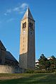
McGraw Tower at Cornell University, a tall and famous building.
-
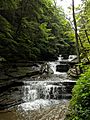
The beautiful Upper Gorge at Buttermilk Falls State Park.


See also
 In Spanish: Condado de Tompkins para niños
