Seneca County, New York facts for kids
Quick facts for kids
Seneca County
|
|||
|---|---|---|---|

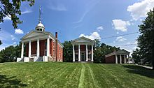
Historic Seneca County Courthouse Complex at Ovid
|
|||
|
|||

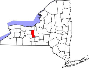
Location within the U.S. state of New York
|
|||
 New York's location within the U.S. |
|||
| Country | |||
| State | |||
| Founded | 1804 | ||
| Named for | Seneca people | ||
| Seat | Waterloo and Ovid | ||
| Largest CDP | Seneca Falls | ||
| Area | |||
| • Total | 390 sq mi (1,000 km2) | ||
| • Land | 324 sq mi (840 km2) | ||
| • Water | 67 sq mi (170 km2) 17% | ||
| Population
(2020)
|
|||
| • Total | 33,814 | ||
| • Density | 104.5/sq mi (40.3/km2) | ||
| Time zone | UTC−5 (Eastern) | ||
| • Summer (DST) | UTC−4 (EDT) | ||
| Congressional district | 24th | ||
Seneca County is a county in the state of New York, USA. In 2020, about 33,814 people lived here. The main county seat is Waterloo. However, Ovid is also a county seat. This means Seneca County has two county seats.
The county got its name from the Seneca Nation. They were a group of Haudenosaunee (Iroquois) people who lived in this area. Seneca County is part of the beautiful Finger Lakes region of New York.
Contents
History of Seneca County
The land that is now Seneca County was once home to the Seneca and Cayuga Native American groups. When counties were first created in New York in 1683, this area was part of a huge county called Albany County. This county was very large, stretching all the way to the Pacific Ocean in theory!
Changes to County Borders
Over time, Albany County became smaller. In 1772, it was divided into three parts. One new part was called Tryon County. This county covered a large western area of New York. It was named after William Tryon, who was the colonial governor.
After the American Revolutionary War, in 1784, Tryon County's name was changed. It became Montgomery County. This was to honor General Richard Montgomery, a hero of the war.
Montgomery County was also very large and was later divided many times.
- In 1789, Ontario County was created from Montgomery County.
- In 1791, Herkimer County was formed from Montgomery County.
- In 1794, Onondaga County was formed from Herkimer County.
- In 1799, Cayuga County was formed from Onondaga County. This county was much bigger than the Cayuga County we know today.
Finally, in 1804, Seneca County was created by splitting off from Cayuga County.
The Two County Seats
Seneca County's first county seat was in Ovid. A courthouse was built there in 1806. Later, in 1817, some southern parts of Seneca County became part of Tompkins County. Because of this, Waterloo became more central, so the county seat moved there in 1819.
But in 1823, more land was taken from Seneca County to form part of Wayne County. This made Waterloo less central. So, a compromise was made: both Ovid and Waterloo would be county seats. This is why Seneca County is known as a "two-shire" county. Even today, the county board holds meetings in Ovid at least once a year to keep this tradition alive.
Important Historical Events
In 1779, during the Revolutionary War, General Sullivan led a campaign against the Iroquois who supported the British. His army destroyed many Cayuga and Seneca villages along Seneca Lake.
On April 6, 1830, an important religious event happened in Seneca County. The Church of Jesus Christ of Latter Day Saints was founded at the home of a farmer named Peter Whitmer. Today, there is a historical visitor's center at that spot.
Geography of Seneca County
Seneca County covers about 390 square miles. About 324 square miles are land, and 67 square miles (17%) are water.
The county is located in the western part of New York. It is part of the beautiful Finger Lakes Region. Cayuga Lake forms its eastern border, and Seneca Lake is on its western side.
A part of the Finger Lakes National Forest is located in the southern part of the county. Both the New York State Thruway and the Erie Canal pass through the northern part of Seneca County.
The former Seneca Army Depot is a large area of land between Cayuga and Seneca Lakes. Sampson State Park is located next to this former army base.
Neighboring Counties
Seneca County shares borders with these other counties:
- Wayne County - to the north
- Cayuga County - to the east
- Tompkins County - to the southeast
- Schuyler County - to the south
- Yates County - to the southwest
- Ontario County - to the west
Main Roads
These are some of the major highways that go through Seneca County:
 Interstate 90 (New York State Thruway)
 U.S. Route 20
 New York State Route 5
 New York State Route 89
 New York State Route 96
 New York State Route 96A
 New York State Route 414
 New York State Route 336
Protected Natural Areas
- Finger Lakes National Forest (part of it)
- Montezuma National Wildlife Refuge (part of it)
- Women's Rights National Historical Park
People of Seneca County (Demographics)
| Historical population | |||
|---|---|---|---|
| Census | Pop. | %± | |
| 1810 | 16,609 | — | |
| 1820 | 23,619 | 42.2% | |
| 1830 | 21,041 | −10.9% | |
| 1840 | 24,874 | 18.2% | |
| 1850 | 25,441 | 2.3% | |
| 1860 | 28,138 | 10.6% | |
| 1870 | 27,823 | −1.1% | |
| 1880 | 29,278 | 5.2% | |
| 1890 | 28,227 | −3.6% | |
| 1900 | 28,114 | −0.4% | |
| 1910 | 26,972 | −4.1% | |
| 1920 | 24,735 | −8.3% | |
| 1930 | 24,983 | 1.0% | |
| 1940 | 25,732 | 3.0% | |
| 1950 | 29,253 | 13.7% | |
| 1960 | 31,984 | 9.3% | |
| 1970 | 35,083 | 9.7% | |
| 1980 | 33,733 | −3.8% | |
| 1990 | 33,683 | −0.1% | |
| 2000 | 33,342 | −1.0% | |
| 2010 | 35,251 | 5.7% | |
| 2020 | 33,814 | −4.1% | |
| U.S. Decennial Census 1790-1960 1900-1990 1990-2000 2010-2020 |
|||
In 2010, there were 35,251 people living in Seneca County. The county had 13,393 households. The average number of people in each household was about 2.51.
Most people in Seneca County are White (93.7%). There are also people who are African American (5.1%), Native American (0.8%), and Asian (0.8%). About 2.7% of the population was Hispanic or Latino.
Most people in the county (95.3%) speak English at home. About 1.6% speak Spanish.
2020 Census Information
| Race | Num. | Perc. |
|---|---|---|
| White (NH) | 29,273 | 86.6% |
| Black or African American (NH) | 1,263 | 3.74% |
| Native American (NH) | 151 | 0.45% |
| Asian (NH) | 268 | 0.8% |
| Pacific Islander (NH) | 3 | 0.01% |
| Other/Mixed (NH) | 1,489 | 4.4% |
| Hispanic or Latino | 1,367 | 4.04% |
Communities in Seneca County
Seneca County has several towns, villages, and smaller communities called hamlets.
Largest Towns and Villages
| # | Location | Population | Type | Region |
|---|---|---|---|---|
| 1 | Seneca Falls | 6,681 | CDP | North |
| 2 | †Waterloo | 5,171 | Village | North |
| 3 | Interlaken | 602 | Village | Cayuga |
| 3 | Ovid | 602 | Village | Seneca |
| 5 | Romulus | 409 | CDP | Cayuga |
| 6 | Lodi | 291 | Village | Seneca |
† - County Seat
Towns
Hamlets
Hamlets are smaller, unincorporated communities.
- Border City
- Bridgeport
- Canoga
- Caywood
- Covert
- Dobbins Corner
- Dublin
- East Geneva
- East Varick
- Fayette
- Kendaia
- MacDougall
- Magee
- Malcom
- Mays Point
- Townsendville
- Tyre
- Varick
- Willard
See also
 In Spanish: Condado de Seneca (Nueva York) para niños
 | Selma Burke |
 | Pauline Powell Burns |
 | Frederick J. Brown |
 | Robert Blackburn |


