Montgomery County, New York facts for kids
Quick facts for kids
Montgomery County
|
|||
|---|---|---|---|

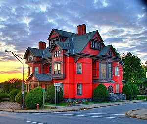
Greene Mansion in Amsterdam
|
|||
|
|||

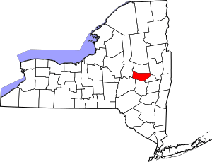
Location within the U.S. state of New York
|
|||
 New York's location within the U.S. |
|||
| Country | |||
| State | |||
| Founded | March 12, 1772 | ||
| Named for | Richard Montgomery | ||
| Seat | Fonda | ||
| Largest city | Amsterdam | ||
| Area | |||
| • Total | 410 sq mi (1,100 km2) | ||
| • Land | 403 sq mi (1,040 km2) | ||
| • Water | 7.3 sq mi (19 km2) 1.8% | ||
| Population
(2020)
|
|||
| • Total | 49,532 | ||
| • Density | 122.9/sq mi (47.5/km2) | ||
| Time zone | UTC−5 (Eastern) | ||
| • Summer (DST) | UTC−4 (EDT) | ||
| Congressional districts | 20th, 21st | ||
Montgomery County is a county located in the state of New York, United States. In 2020, about 49,532 people lived there. The main town where the county government is located is Fonda.
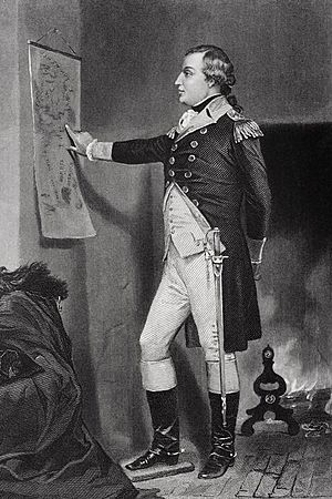
The county was named after Richard Montgomery. He was an important general during the American Revolutionary War. He died in 1775 during the Battle of Quebec. Montgomery County is part of the Mohawk Valley area of New York. It is also part of the larger Albany-Schenectady-Troy area.
Long ago, the Mohawk people lived in this area. They were one of the original Five Nations of the Iroquois Confederacy. The county was first created in 1772 by the British. It was called Tryon County back then. After America won its independence, the county was renamed Montgomery County in 1784. This honored General Montgomery.
Montgomery County includes the Amsterdam, NY area. The Mohawk River flows through the county, with towns on both its north and south sides.
Contents
History of Montgomery County
For hundreds of years before Europeans arrived, the Mohawk people lived in this area. During the American Revolutionary War, many Mohawk warriors fought alongside the British. When the British lost the war, they gave the land of the Iroquois tribes to the United States. They did this without asking the tribes or including them in the peace talks.
In 1784, after the American Revolutionary War ended, the European-American settlers changed the name of Tryon County to Montgomery County. This was done to honor General Richard Montgomery. He had captured several places in Canada and died in 1775 while trying to capture Quebec City. The new name replaced the old one, which honored the last British governor of New York.
Over the years, Montgomery County became smaller as new counties were created from its land. For example, in 1789, Ontario County was formed. It was much larger than the present-day Ontario County. In 1791, Herkimer, Otsego, and Tioga counties were also created from parts of Montgomery County. Later, in 1816, Hamilton County was split off.
In May 1836, the county seat (the main government town) moved from Johnstown to Fonda. Then, in April 1838, Fulton County was created from Montgomery County. Johnstown became the county seat for the new Fulton County.
In 2012, people in Montgomery County voted to approve a new way of governing the county. This made it the 21st county in New York to have its own special government plan. In 2013, Matthew L. Ossenfort was elected as the first County Executive. He started his job in 2014, when the new government plan began. Under this new plan, the old Board of Supervisors was replaced by a nine-member County Legislature. These members are elected from different areas of the county. Thomas L. Quackenbush was chosen as the first chairman of this new legislative group.
Geography of Montgomery County
Montgomery County covers about 410 square miles. Most of this area, about 403 square miles, is land. The remaining 7.3 square miles, or 1.8%, is water.
The county is located in the central part of New York State. It is west of the city of Schenectady and northwest of Albany.
Neighboring Counties
Montgomery County shares borders with these other counties:
- Fulton County - to the north
- Saratoga County - to the east
- Schenectady County - to the east
- Schoharie County - to the south
- Otsego County - to the southwest
- Herkimer County - to the west
The Erie Canal runs through Montgomery County, right next to the Mohawk River. This canal was very important because it connected the Great Lakes with the Hudson River. This meant boats could travel from the Great Lakes all the way to the Atlantic Ocean through New York City. Many towns and villages grew up along the canal because it was a busy route for trade and travel. Later, when railroads were built, they took over much of the canal's traffic. Today, the Erie Canal and its locks are mostly used for fun, like boating and tourism.
At the time the canal was built, Montgomery County had a special spot called 'The Noses'. This was the only place where the Appalachian Mountains had a natural break. Because of this, it was known as "the gateway to the West." Later, the NYS Thruway (a major highway) was built in the same area.
Montgomery County is in the middle of the state's Mohawk Valley region. In the southern part of the county, you can see the foothills of the Catskill Mountains. In the north, there are foothills of the Adirondack Mountains.
People of Montgomery County (Demographics)
| Historical population | |||
|---|---|---|---|
| Census | Pop. | %± | |
| 1790 | 28,848 | — | |
| 1800 | 22,051 | −23.6% | |
| 1810 | 41,214 | 86.9% | |
| 1820 | 37,569 | −8.8% | |
| 1830 | 43,715 | 16.4% | |
| 1840 | 35,818 | −18.1% | |
| 1850 | 31,992 | −10.7% | |
| 1860 | 30,866 | −3.5% | |
| 1870 | 34,457 | 11.6% | |
| 1880 | 38,315 | 11.2% | |
| 1890 | 45,699 | 19.3% | |
| 1900 | 47,488 | 3.9% | |
| 1910 | 57,567 | 21.2% | |
| 1920 | 57,928 | 0.6% | |
| 1930 | 60,076 | 3.7% | |
| 1940 | 59,142 | −1.6% | |
| 1950 | 59,594 | 0.8% | |
| 1960 | 57,240 | −4.0% | |
| 1970 | 55,883 | −2.4% | |
| 1980 | 53,439 | −4.4% | |
| 1990 | 51,981 | −2.7% | |
| 2000 | 49,708 | −4.4% | |
| 2010 | 50,219 | 1.0% | |
| 2020 | 49,532 | −1.4% | |
| U.S. Decennial Census 1790-1960 1900-1990 1990-2000 2010-2020 |
|||
In 2010, there were about 50,208 people living in Montgomery County. There were 20,073 households and 13,131 families. The county had about 123 people per square mile. There were 22,522 homes, with about 56 homes per square mile.
Most people in the county (92.87%) were White. About 1.15% were African American, and 0.25% were Native American. About 12.91% of the population identified as Hispanic or Latino.
Many people in Montgomery County have roots from different countries. In 2010, the largest groups were Italian (19.0%), German (15.9%), Polish (13.5%), and Puerto Rican (9.8%). Most people (86.8%) spoke English at home. About 9.3% spoke Spanish.
In 2010, about 29.40% of households had children under 18 living with them. The average household had 2.42 people. The average family had 2.98 people.
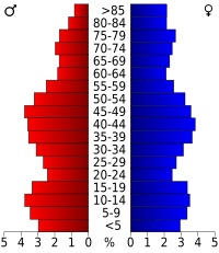
The population was spread out by age. About 24.50% were under 18 years old. About 19.20% were 65 years or older. The average age was 40 years old.
The median income for a household in the county was $33,128. For a family, it was $40,688. About 13.7% of the population lived below the poverty line. This included 17.80% of those under 18 and 9.89% of those 65 or older.
2020 Census
| Race | Num. | Perc. |
|---|---|---|
| White (Not Hispanic) | 38,237 | 77.2% |
| Black or African American (Not Hispanic) | 987 | 2.0% |
| Native American (Not Hispanic) | 83 | 0.2% |
| Asian (Not Hispanic) | 479 | 1.0% |
| Pacific Islander (Not Hispanic) | 9 | 0.01% |
| Other/Mixed (Not Hispanic) | 2,425 | 5.0% |
| Hispanic or Latino | 7,312 | 15.0% |
Communities in Montgomery County
Montgomery County has one city, several towns, and many villages and hamlets.
City
Towns
Villages
- Ames
- Canajoharie
- Fonda (This is the county seat)
- Fort Plain
- Fultonville
- Hagaman
- Nelliston
- Palatine Bridge
- St. Johnsville
Census-designated place
Hamlets
- Auriesville
- Fort Hunter
- Freysbush
- Minaville
- Sprakers
- Sprout Brook
- Valley Brook
Notable people from Montgomery County
Many interesting people have come from Montgomery County:
- Joseph Brant: A Mohawk leader who was important during the American Revolution. He was from Canajoharie, New York.
- Charles Couch: A politician who served in Wisconsin. He was born in Mohawk in 1833.
- Bud Fowler: The first African American professional baseball player. He was born in Fort Plain, New York.
- Sheldon Jackson: A Presbyterian missionary who was born in Minaville in 1834.
- Cady Staley: The first President of Case School of Applied Science (now Case Western Reserve University). He was born in Minaville in 1840.
- Kirk Douglas: A famous actor.
- George A. Mitchell: The person who founded the city of Cadillac, Michigan.
- David Pietrusza: An author.
Error: no page names specified (help). In Spanish: Condado de Montgomery (Nueva York) para niños
 | Madam C. J. Walker |
 | Janet Emerson Bashen |
 | Annie Turnbo Malone |
 | Maggie L. Walker |


