
Fultonville, New York facts for kids
Quick facts for kids
Fultonville, New York
|
|
|---|---|
|
Village
|
|

Fultonville, New York
Location in New York
|
|
| Country | United States |
| State | New York |
| County | Montgomery |
| Area | |
| • Total | 0.52 sq mi (1.35 km2) |
| • Land | 0.48 sq mi (1.24 km2) |
| • Water | 0.04 sq mi (0.11 km2) |
| Elevation | 289 ft (88 m) |
| Population
(2020)
|
|
| • Total | 742 |
| • Density | 1,555.56/sq mi (600.55/km2) |
| Time zone | UTC-5 (Eastern (EST)) |
| • Summer (DST) | UTC-4 (EDT) |
| ZIP codes |
12016, 12072
|
| Area code(s) | 518 |
| FIPS code | 36-27859 |
| GNIS feature ID | 0950807 |
|
Fultonville Historic District
|
|
| NRHP reference No. | 100004242 |
|---|---|
| Designated HD | August 8, 2019 |
Fultonville is a small village in Montgomery County, New York, United States. It is named after Robert Fulton, who invented the steamboat.
The Village of Fultonville is located on the south side of the Mohawk River. It is part of the Town of Glen and sits west of the city of Amsterdam.
In 2019, an important part of the village was added to the National Register of Historic Places. This area is called the Fultonville Historic District. It was recognized for its old buildings from the 1800s and early 1900s. These buildings show what the village looked like when the Erie Canal was a big part of its growth.
Contents
History of Fultonville
-
Starin Mausoleum in Fultonville Cemetery (1907-1915)

Long ago, in the mid-1600s, a Mohawk village called Andagaron was located about a mile west of where Fultonville is now.

The first European settlement in this area began around 1750. A person named John Evart Van Epps settled here. People called the area "Van Epps Swamp" because of the wet land near the river. During the American Revolution, the homes in this settlement were burned down.

Fultonville was officially started around 1824. This was because people knew the Erie Canal would soon open. The village became an official village on August 9, 1848.
Later, in 1889, the West Shore Railroad built a train station in the village. This railroad later became part of the New York Central system.
A very successful businessman named John Henry Starin was born nearby in 1825. His family was well-known in the area. John Henry Starin became one of the richest people in America. He led a large transportation company that worked on rivers and harbors. He also helped manage banks in New York City and Fultonville.
Village Leaders Over Time
Fultonville has had many leaders since it became a village. The first president of the village was Howland Fish.
Over the years, many people have served as mayor. The current mayor is Timothy Morford.
Attractions to See
Cobblestone Hall and Free Library

The Cobblestone Hall and Free Library building was built before 1868. It used to be the home of C. B. Freeman, who owned the Fultonville Steam Mills. Later, a large wooden part was added to the back of the building. It was then known as "Cobblestone Free Hall and Library." Today, most of the original building is still standing. It has been changed into a private home.
Geography of Fultonville
Fultonville is located at 42°56′48″N 74°22′10″W / 42.94667°N 74.36944°W.
The village covers about 0.5 square miles (1.3 square kilometers) of land. A small part, about 0.04 square miles (0.11 square kilometers), is water.
Fultonville is on the south side of the Mohawk River. Across the river is the Village of Fonda. A bridge, NY-30A, connects the two villages. The Mohawk River here is also part of the Erie Canal.
The New York State Thruway (Interstate 90) goes through Fultonville. Another road, New York State Route 5S (Maple Avenue), runs next to the Thruway. It crosses New York State Route 30A (Main Street) in the village.
Climate in Fultonville
Fultonville has a climate that is sometimes called "hemiboreal." This means it has cold winters and warm summers. The average temperature for the year is about 45.7°F (7.6°C).
- The warmest month is July, with an average temperature of 79.5°F (26.4°C).
- The coldest month is January, with an average temperature of 26.6°F (−3°C).
The village gets about 33.75 inches (857.25 mm) of rain each year. May is usually the wettest month, and September is the driest.
| Weather chart for Fultonville | |||||||||||||||||||||||||||||||||||||||||||||||
|---|---|---|---|---|---|---|---|---|---|---|---|---|---|---|---|---|---|---|---|---|---|---|---|---|---|---|---|---|---|---|---|---|---|---|---|---|---|---|---|---|---|---|---|---|---|---|---|
| J | F | M | A | M | J | J | A | S | O | N | D | ||||||||||||||||||||||||||||||||||||
|
2.6
27
15
|
2.7
30
17
|
2.5
39
24
|
3.3
53
35
|
3.5
66
46
|
3.2
73
52
|
2.5
80
58
|
2.6
77
57
|
2.1
71
51
|
3.2
56
42
|
2.4
44
31
|
3.1
33
23
|
||||||||||||||||||||||||||||||||||||
| temperatures in °F precipitation totals in inches |
|||||||||||||||||||||||||||||||||||||||||||||||
|
Metric conversion
|
|||||||||||||||||||||||||||||||||||||||||||||||
| Month | Jan | Feb | Mar | Apr | May | Jun | Jul | Aug | Sep | Oct | Nov | Dec | Year |
|---|---|---|---|---|---|---|---|---|---|---|---|---|---|
| Average precipitation inches (mm) | 2.56 (65) |
2.72 (69) |
2.48 (63) |
3.27 (83) |
3.46 (88) |
3.19 (81) |
2.52 (64) |
2.64 (67) |
2.13 (54) |
3.23 (82) |
2.44 (62) |
3.11 (79) |
33.75 (857) |
| Average snowfall inches (cm) | 10.24 (26.0) |
11.54 (29.3) |
6.46 (16.4) |
2.05 (5.2) |
0.16 (0.41) |
0.0 (0.0) |
0.0 (0.0) |
0.0 (0.0) |
0.0 (0.0) |
0.63 (1.6) |
4.45 (11.3) |
7.95 (20.2) |
43.48 (110.4) |
| Average precipitation days (≥ 0.01 in) | 9.8 | 8.9 | 14.8 | 16.3 | 17.2 | 15.9 | 16.7 | 15.3 | 12.0 | 14.1 | 12.3 | 12.2 | 165.5 |
| Average snowy days (≥ 0.1 in) | 17.5 | 16.6 | 12.3 | 4.2 | 0.4 | 0.0 | 0.0 | 0.0 | 0.0 | 0.7 | 7.2 | 13.8 | 72.7 |
| Month | Jan | Feb | Mar | Apr | May | Jun | Jul | Aug | Sep | Oct | Nov | Dec | Year |
|---|---|---|---|---|---|---|---|---|---|---|---|---|---|
| Mean monthly sunshine hours | 280.0 | 281.9 | 372.0 | 391.0 | 436.1 | 451.0 | 465.0 | 405.6 | 361.5 | 341.0 | 272.0 | 279.5 | 4,336.6 |
| Mean daily daylight hours | 9.4 | 8.4 | 10.7 | 10.4 | 11.8 | 11.8 | 11.3 | 12.3 | 15.5 | 13.7 | 13.3 | 10.2 | 11.6 |
| Percent possible sunshine | 38 | 42 | 50 | 54 | 59 | 63 | 62 | 55 | 50 | 46 | 38 | 37 | 49 |
| Average ultraviolet index | 1 | 1 | 2 | 3 | 5 | 5 | 5 | 5 | 3 | 2 | 2 | 1 | 3 |
People in Fultonville
| Historical population | |||
|---|---|---|---|
| Census | Pop. | %± | |
| 1870 | 1,117 | — | |
| 1880 | 881 | −21.1% | |
| 1890 | 1,122 | 27.4% | |
| 1900 | 977 | −12.9% | |
| 1910 | 812 | −16.9% | |
| 1920 | 869 | 7.0% | |
| 1930 | 831 | −4.4% | |
| 1940 | 806 | −3.0% | |
| 1950 | 840 | 4.2% | |
| 1960 | 815 | −3.0% | |
| 1970 | 812 | −0.4% | |
| 1980 | 777 | −4.3% | |
| 1990 | 748 | −3.7% | |
| 2000 | 710 | −5.1% | |
| 2010 | 784 | 10.4% | |
| 2020 | 742 | −5.4% | |
| U.S. Decennial Census | |||
In 2020, about 742 people lived in Fultonville. The village has had different numbers of people living there over the years.
In 2000, there were 710 people living in the village. Most people were from a White background. A small number of people were from a Latino background. Almost everyone spoke English at home.
About one-third of the homes had children under 18 living there. Many homes were married couples living together. Some homes were led by a single parent. About one-quarter of all homes had just one person living there. The average family size was about three people.
The median age in the village was 35 years old. This means half the people were younger than 35 and half were older.
Education in Fultonville
Students in Fultonville go to schools in the Fonda-Fultonville Central School District. These schools are located in Fonda, which is very close by.
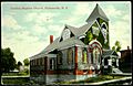
Places of Worship
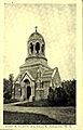
-
Reformed Church (1907-1915)
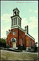
-
Methodist Church (1907-1915)
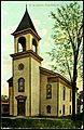
-
Calvary Baptist Church (1907-1915)


- Fultonville Reformed Church
- Fonda-Fultonville United Methodist Church (This church was torn down after a fire in 2017.)
- Calvary Baptist Church (This church is no longer in use.)
Cemeteries
- Maple Avenue Cemetery (Started in 1874)
- Old Fultonville Cemetery
See also
 In Spanish: Fultonville para niños
