Mohawk River facts for kids
Quick facts for kids Mohawk River |
|
|---|---|

|
|

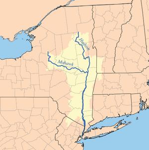
Hudson River watershed map showing the Mohawk River
|
|
| Country | United States |
| State | New York |
| Regions | Central New York, Capital Region |
| Counties | Oneida, Herkimer, Montgomery, Schenectady, Albany, Rensselaer, Saratoga, |
| Cities | Rome, Utica, Little Falls, Amsterdam, Schenectady, Cohoes |
| Physical characteristics | |
| Main source | East Branch Mohawk River S of Mohawk Hill 43°30′51″N 75°28′02″W / 43.5142362°N 75.4671217°W |
| 2nd source | West Branch Mohawk River W of West Branch 43°22′12″N 75°30′29″W / 43.3700696°N 75.5079556°W |
| River mouth | Hudson River Border of Albany County, Saratoga County, and Rensselaer County, New York 10 ft (3.0 m) 42°45′39″N 73°41′13″W / 42.76083°N 73.68694°W |
| Discharge (location 2) |
|
| Basin features | |
| River system | Hudson River |
| Tributaries |
|
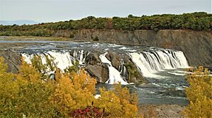
| Waterfalls | Cohoes Falls |
The Mohawk River is a long river in New York, stretching about 149 miles (240 km). It is the biggest tributary (a smaller river flowing into a larger one) of the Hudson River. The Mohawk River joins the Hudson in Cohoes, New York, which is just north of Albany, the state capital.
The river gets its name from the Mohawk Nation, a group of Native Americans who were part of the Iroquois Confederacy. In the early 1800s, the Mohawk River's valley was very important. It provided the path and water for building the Erie Canal, which helped New York grow a lot.
The two most important rivers that flow into the Mohawk are the Schoharie Creek and the West Canada Creek. The Schoharie Creek brings in over a quarter of the Mohawk River's water. The West Canada Creek adds another big portion.
Contents
Where Does the Mohawk River Flow?
The Mohawk River starts where two smaller rivers, the West Branch Mohawk River and East Branch Mohawk River, meet in Oneida County. It generally flows southeast, picking up water from smaller brooks like Blue Brook and McMullen Brook.
Near Hillside, the Lansing Kill joins the river. The Mohawk then flows towards North Western, getting more water from Stringer Brook. After that, Tannery Brook and Wells Creek join in Frenchville.
The river then turns southwest and flows towards Westernville, where it enters Delta Reservoir. After leaving the reservoir, it heads south towards Rome, passing the Rome Fish Hatchery. On the south side of Rome, the river connects with the Erie Canal and starts flowing east.
From Rome, the river continues east through the Mohawk Valley. It passes through cities like Utica, Little Falls, Canajoharie, Amsterdam, and Schenectady. Finally, it flows into the Hudson River in Cohoes, New York, just north of Albany.
How the River Was Changed
The Mohawk River and the Erie Canal act like a highway. They connect the Hudson River and New York Harbor to the Great Lakes at Buffalo, New York. This connection was very important for trade and travel.
The lower part of the Mohawk River has many structures built on it. There are five permanent dams and nine movable dams. These dams help control the water flow. There are also five active hydropower plants that use the river's water to create electricity.
The Schoharie Creek and West Canada Creek are the main rivers that feed into the Mohawk. Both of these have important dams. For example, the Hinckley Dam is on the West Canada Creek. The Gilboa Dam is on the upper part of Schoharie Creek. The Gilboa Dam was built in 1926 to help supply water to New York City. It is currently being repaired and updated.
The River's Ancient Story: Geology
The Mohawk River's watershed (the area of land where all the water drains into the river) covers a large part of New York. This includes the Catskill Mountains, the Mohawk Valley itself, and parts of the southern Adirondack Mountains. Each of these areas has different types of rocks.
The rocks generally get younger as you go south. Most of the rocks in this area are Paleozoic sedimentary rocks. These rocks sit on top of much older metamorphic rocks from the Grenville orogeny (about 1.1 billion years old) found in the Adirondacks.
The main part of the Mohawk River flows over limestone and sandstone rocks. The rivers flowing from the Catskill Mountains in the south flow over Devonian limestones and thick layers of sandstones and shale.
How Glaciers Shaped the Valley
During the Pleistocene Ice Age (about 1.8 million to 10,000 years ago), huge sheets of ice called glaciers covered the area. These glaciers changed the land a lot. They scraped away rock and left behind a mix of boulders and clay.
As the glaciers melted, they formed large glacial lakes. About 13,350 years ago, one of these lakes, Glacial Lake Iroquois, drained very quickly. The massive amount of water flowed through what is now the Mohawk Valley. This powerful flow carved out deep holes, like the Potholes at Little Falls. It also left behind large amounts of sand and gravel. This sand and gravel is now an important source of groundwater for cities, like the Scotia Delta.
The Name: Mohawk River
The river is named after the Mohawk Nation. They are a Native American group that was part of the Iroquois Confederacy. In the 1700s and earlier, the Mohawk people lived in the Mohawk Valley.
Their land stretched far and wide. It went north to the St. Lawrence River in Canada. To the south, it reached into New Jersey and Pennsylvania. To the east, it went to the Green Mountains in Vermont. To the west, it bordered the land of the Oneida Nation, another Iroquois group.
The Mohawk name for the river is Teionontatátie. This means "a river flowing through a mountain" or "going round a mountain."
A River of History and Travel
The Mohawk River has always been important for travel and moving west. It provided an easier path through the Appalachian Mountains. This path was between the Catskill Mountains to the south and the Adirondack Mountains to the north. It was much easier to travel through the valley than over the mountains.
Because of its important location, the river was a key area during wars. Many important battles of the French and Indian War and the American Revolutionary War happened here. The rich land of the Mohawk Valley also attracted many early settlers.
Early Explorers and Settlements
The Mohawk River was the main travel route for the native Mohawk people. The first European to explore the Mohawk River was a Dutchman named Harman Meyndertsz van den Bogaert in 1634. He traveled upstream from Albany for 100 miles, exploring all the Mohawk territory.
In 1661, Dutch settlers started the city of Schenectady on the Mohawk River. It was about 19 miles (31 km) from Albany. For 50 years, Schenectady was the edge of Dutch-English control in the Mohawk Valley.
In 1712, the British took control of New York. They built Fort Hunter where the Mohawk and Schoharie Creek meet. This was about 22 miles (35 km) upriver from Schenectady. Around 600 Palatine Germans (people from Germany) settled along the Mohawk and Schoharie Creek.
A Swedish explorer and botanist, Pehr Kalm, visited the area in the mid-1700s. He met some of the Iroquois people and wrote about their customs in his journal.
Modern Transportation
In the early 1800s, water travel was vital for moving people and goods. A company was formed to build the Erie Canal from the Mohawk River to Lake Erie. This canal made it much easier for European settlers to move west.
The Mohawk Valley is still important for transportation today. Railroads follow the river's path. Major east-west roads like Route 5 and Interstate 90 also run through the valley.
The Mohawk River Heritage Corridor Commission was created in 1997. Its job is to protect and promote the natural beauty and history of the Mohawk River.

Flooding and Water Flow
The Mohawk River has a long history of flooding, going back to the 1600s. About 184 billion cubic feet (5.21 km3) of water flows through the Mohawk River each year. Most of this water comes in the spring when snow melts quickly.
The most water flows through the river between late March and early April. The lowest amount of water flows in late August. There have been many big and damaging floods along the river's entire length.
Because the river often freezes in winter, the spring melt can cause ice to break up. These large pieces of ice can get stuck and jammed along the river. This usually happens in late March. These ice jams can cause a lot of damage to buildings near the river. The worst flood on the Mohawk River happened in March 1914. It caused huge damage because of the massive amounts of ice. Ice jams happen about every other year.
One major flood happened in June 2006. Heavy rains caused widespread flooding in the Mohawk and other river areas. This event caused over $227 million in damage and four lives were lost. The upper parts of the Mohawk watershed were hit especially hard.
The Mohawk River also had big floods in August and September 2011. This was due to very heavy rains from Hurricane Irene and Tropical Storm Lee. Many of the Mohawk Barge Canal locks were badly damaged.
Another big flood occurred in June 2013. Weeks of heavy rain led to this flood. In one hour, 4 inches of rain fell in the Jordanville area. The next day, the Mohawk River flooded its valley. Many residents were stuck and without power for about a week. There was a lot of damage, especially in Mohawk and Fort Plain.
To protect the city of Amsterdam, work was done on the Mohawk River and South Chuctanunda Creek. New flood walls were built to protect the city from large floods. These flood walls helped prevent $13.6 million in damages from Tropical Storm Lee and Hurricane Irene. In 2012, Governor Cuomo announced a project to improve these flood walls, costing $164,248.
Managing the River's Health
For a long time, the Mohawk watershed did not have a special plan to manage its health. In 2010, the New York State Department of Environmental Conservation released the Mohawk River Basin Action Agenda. This was the first plan to manage the watershed.
The plan has five main goals to improve the river's ecosystem health and the region's well-being. This plan was made with help from many groups and people in the area. It suggests an approach to managing the watershed that looks at the entire ecosystem. In 2014, Riverkeeper, a group that works for clean water, announced they would expand their efforts to the Mohawk River.
Rivers That Join the Mohawk
Right Side Tributaries
- McMullen Brook
- Deans Gulf
- Wheelers Creek
- Oriskany Creek
- Sauquoit Creek
- Starch Factory Creek
- Bonny Brook
- Moyer Creek
- Steele Creek
- Fulmer Creek
- Nowadaga Creek
- Otsquago Creek
- Canajoharie Creek
- Flat Creek
- Lasher Creek
- Yatesville Creek
- Van Wie Creek
- Auries Creek
- Schoharie Creek
- South Chuctanunda Creek
- Terwilleger Creek
- Sandsea Kill
- Moccasin Kill
- Plotter Kill
- Lisha Kill
- Shakers Creek
- Delphus Kill
Left Side Tributaries
- Blue Brook
- Haynes Brook
- Lansing Kill
- Stringer Brook
- Tannery Brook
- Wells Creek
- Hurlbut Glen Brook
- Sixmile Creek
- Ninemile Creek
- Crane Creek
- Decks Creek
- Jones Creek
- Gridley Creek
- Reall Creek
- Budlong Creek
- Wood Creek
- Knapp Brook
- Burch Creek
- Sterling Creek
- Pratt Creek
- Bridenbecker Creek
- West Canada Creek
- Beaver Brook
- Crum Creek
- East Canada Creek
- Timmerman Creek
- Zimmerman Creek
- Mother Creek
- Caroga Creek
- Knauderack Creek
- Briggs Run
- Cayadutta Creek
- Danascara Creek
- Kayaderosseras Creek
- Dove Creek
- Bunn Creek
- North Chuctanunda Creek
- Degraff Creek
- Evas Kill
- Compaanen Kill
- Chaughtanoonda Creek
- Verf Kill
- Washout Creek
- Alplaus Kill
- Stony Creek
Islands in the Mohawk River
- Abeel Island – Near Fort Plain.
- Bronson Island – West of Amsterdam.
- Davey Island – South of Amsterdam.
- Dalys Island – Near Scotia.
- Giording Island – South of Amsterdam.
- Goat Island – North of Niskayuna.
- Isle of the Oneidas – South of Scotia.
- Isle of the Onondagas – South of Scotia.
- Isle of the Senecas – South of Scotia.
- Isle of the Mohawks – South of Scotia.
- Isle of the Cayugas – South of Scotia.
- Upper Pepper Island – South of Fort Johnson.
- Pepper Island – South of Fort Johnson.
- Robb Island – Southeast of Fort Johnson.
- Swart Island – West of Hoffmans.
See also
- List of rivers of New York
- Oneida Carry
- Great Flats Nature Trail
- In Spanish: Río Mohawk para niños
 | John T. Biggers |
 | Thomas Blackshear |
 | Mark Bradford |
 | Beverly Buchanan |


