Otsquago Creek facts for kids
Quick facts for kids Otsquago Creek |
|
|---|---|

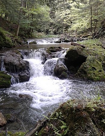
Rapids on the creek by Vanhornesville
|
|
|
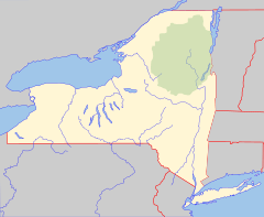
Location of the mouth of Otsquago Creek
|
|
| Country | United States |
| State | New York |
| Region | Central New York Region |
| Counties | Herkimer, Montgomery |
| Towns | Stark, Minden |
| Physical characteristics | |
| Main source | Un-named Marshy Field Van Hornesville, New York 1,360 ft (410 m) 42°54′27″N 74°50′25″W / 42.9075722°N 74.84015°W |
| River mouth | Mohawk River Fort Plain, New York 295 ft (90 m) 42°55′57″N 74°37′04″W / 42.9325727°N 74.6176423°W |
| Length | 18.6 mi (29.9 km) |
| Basin features | |
| Basin size | 61.3 sq mi (159 km2) |
| Tributaries |
|
| Waterfalls | Creamery Falls, Van Hornesville Falls |
Otsquago Creek is a river in New York. It flows into the Mohawk River near Fort Plain, New York. The name "Otsquago" comes from the Mohawk Indian language. It means "under the bridge," possibly pointing to early bridges made from fallen trees. Some old maps also call it "Otsquage," which means "healing waters."
The creek starts about 12 miles (19 km) southeast of where it ends. Its source is a marshy field near Van Hornesville, New York. This spot is 1,360 feet (415 m) above sea level. Two waterfalls, Creamery Falls and Van Hornesville Falls, are found on the creek near Van Hornesville.
Contents
History of Otsquago Creek
Before Europeans arrived, the Iroquois Indians lived around Otsquago Creek. Many Indian villages were built along its banks. One important village was called Otstungo. It was located on a piece of land between Otstungo Creek and Otsquago Creek.
This village was protected by steep cliffs on most sides. People could only enter it from the south. Many old tools and items have been found here. These include stone axes, arrowheads, spears, and bone tools.
Near Van Hornesville, there were sulfur and iron springs. The Indians called these "Otsquage," meaning "healing waters." They believed these springs had strong healing powers.
In 1794, Mr. VanHorne opened a store in what is now Van Hornesville. By 1800, a mill for finishing cloth was working on the creek. More mills, like sawmills and carding mills, opened by 1814. In 1836, a cotton mill was built on the creek near Van Hornesville.
Otsquago Creek's Watershed
A watershed is the area of land where all the water drains into a specific river or creek. The Otsquago Creek's watershed covers 61.3 square miles (158.8 km²). This area makes up about 1.77% of the total Mohawk River watershed.
The creek starts in the Town of Stark. Its lower half flows through the Town of Minden. Most of the land in the watershed is open space. About one-third (33.9%) is covered by forests.
The upper part of the watershed has farms and small towns like Van Hornesville. The lower part has more homes and businesses, especially in the Village of Fort Plain. The creek flows downhill at an average slope of 1.5%. The upper part is steeper, with a 3% slope.
Water Flow and Flooding
How Water Flows
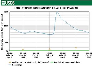
The United States Geological Survey (USGS) measures the water flow in Otsquago Creek. They have a station near the mouth of the creek in Fort Plain. This station has been recording data since 1993.
The highest water flow recorded at this station was 24,600 cubic feet (697 m³) per second. This happened during a big flood on June 28, 2013. The lowest flow was 0.6 cubic feet (0.017 m³) per second on November 30, 1964.
Flooding Along the Creek
Flooding has happened many times along Otsquago Creek. It has caused a lot of damage in towns like Van Hornesville and Fort Plain. One reason for flooding is that large amounts of dirt and rocks wash downstream during heavy rains. This material can block bridges and make flooding worse.
The part of the creek near its mouth can also flood when the Mohawk River rises. This is called backwater flooding.
Major floods occurred on September 22, 1938, October 2, 1945, October 17, 1955, and March 11, 1976. On March 5, 1979, ice blocking the Mohawk River caused both rivers to overflow. This led to a lot of damage in Fort Plain. Water was reported to be four feet deep in some streets.
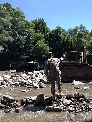
Another severe flood happened in June 2006. Then, in June 2013, there was a very serious flood along the entire creek. It flooded downtown Fort Plain and reached all the way to Van Hornesville. A road was washed out, and a school was damaged. Sadly, one person died in this storm.
In February 2017, a flood warning caused 625 residents to evacuate. Luckily, the water went down quickly, and no major damage occurred.
Fishing in Otsquago Creek
You can find different types of trout in Otsquago Creek. These include brook trout, brown trout, and rainbow trout. In 2019, many brown trout and rainbow trout were released into the creek. This helps keep the fish population healthy for fishing.
Protecting the Creek
People are working to protect Otsquago Creek and its surroundings.
In 2015, there were plans to expand a gas station near the creek. People worried about the pollution it might cause. The valley's shape could trap these emissions, making the air quality worse.
The Robert B. Woodruff Outdoor Learning Center opened in 1984. It covers 50 acres (20 ha) within the Otsquago gorge. This center has trails that lead to waterfalls and limestone caves. It helps people explore and learn about the area.
The Young family also worked with Otsego Land Trust to protect land near the creek. They conserved about 147 acres (59 ha) to help protect the village's water supply. Later, they donated another 40 acres (16 ha) for even more protection.


