
New York facts for kids
Quick facts for kids
New York
|
|||
|---|---|---|---|
| State of New York | |||
|
|||
| Nickname(s): | |||
| Motto(s):
Excelsior
Ever upward |
|||

Location of New York within the United States
|
|||
| Country | United States | ||
| Before statehood | Province of New York | ||
| Admitted to the Union | July 26, 1788 (11th) | ||
| Capital | Albany | ||
| Largest city | New York | ||
| Largest county or equivalent | Kings (Brooklyn) | ||
| Largest metro and urban areas | New York metropolitan area | ||
| Legislature | State Legislature | ||
| • Upper house | State Senate | ||
| • Lower house | State Assembly | ||
| Judiciary | New York Court of Appeals | ||
| U.S. senators |
|
||
| U.S. House delegation |
|
||
| Area | |||
| • Total | 54,555 sq mi (141,298 km2) | ||
| • Land | 47,126 sq mi (122,057 km2) | ||
| • Water | 7,429 sq mi (19,240 km2) 13.6% | ||
| Area rank | 27th | ||
| Dimensions | |||
| • Length | 330 mi (530 km) | ||
| • Width | 285 mi (455 km) | ||
| Elevation | 1,000 ft (300 m) | ||
| Highest elevation | 5,344 ft (1,629 m) | ||
| Lowest elevation | 0 ft (0 m) | ||
| Population
(2024)
|
|||
| • Total | |||
| • Rank | 4th | ||
| • Density | 428.66/sq mi (165.51/km2) | ||
| • Density rank | 8th | ||
| • Median household income | $82,100 (2023) | ||
| • Income rank | 14th | ||
| Demonym(s) | New Yorker | ||
| Language | |||
| • Spoken language | |||
| Time zone | UTC– 05:00 (EST) | ||
| • Summer (DST) | UTC– 04:00 (EDT) | ||
| USPS abbreviation |
NY
|
||
| ISO 3166 code | US-NY | ||
| Traditional abbreviation | N.Y. | ||
| Latitude | 40° 30′ N to 45° 1′ N | ||
| Longitude | 71° 51′ W to 79° 46′ W | ||

.svg)
| Bird | Eastern bluebird |
|---|---|
| Fish | Brook trout (fresh water), Striped bass (salt water) |
| Flower | Rose |
| Fruit | Apple |
| Tree | Sugar maple, Lilac bush |
| Insect | Nine-spotted ladybug |
| Sport | Baseball |
New York, also known as New York State, is a state in the northeastern United States. It shares borders with New England to the east and Canada to the north. To the south, it borders Pennsylvania and New Jersey. New York reaches both the Atlantic Ocean and the Great Lakes.
New York is the fourth-most populous state in the U.S. About 20 million people live here. It is the 27th-largest state by land area. New York covers about 54,556 square miles (141,298 km2).
The state has a diverse landscape. Downstate includes New York City, the largest city in the U.S. It also has Long Island, the most populated island in the nation. This area is part of the huge New York metropolitan area. About two-thirds of the state's people live here.
The larger Upstate area stretches from the Great Lakes to Lake Champlain. It features the Adirondack Mountains and the Catskill Mountains. The Mohawk River Valley cuts through the mountains. It flows into the Hudson River valley near Albany, the state capital. Western New York includes Buffalo and Rochester. This area is part of the Great Lakes region. It borders Lake Ontario and Lake Erie. Central New York is centered around Syracuse. The beautiful Finger Lakes are a popular tourist spot. The Southern Tier is in the south, along the Pennsylvania border.
New York was one of the original Thirteen Colonies that formed the United States. Native American tribes like the Algonquians and Iroquois lived here for thousands of years. In 1609, Henry Hudson explored the area. The Dutch then started the colony of New Netherland in 1621. England took control in 1664 and renamed it the Province of New York.
During the American Revolutionary War, colonists fought for independence. New York became a state in 1788. In the 1800s, the Erie Canal helped New York grow. This made it a very important state. It earned the nickname "Empire State". Today, New York is known for new ideas and tolerance. It attracts many visitors from around the world.
Famous landmarks include Times Square, Central Park, Niagara Falls, and Grand Central Terminal. New York has about 200 colleges and universities. These include Columbia University and Cornell University. New York City is home to the headquarters of the United Nations. It is often called a global center for culture, finance, and media.
History of New York State
Early Explorers and Settlements

In 1524, Giovanni da Verrazzano, an Italian explorer, sailed along the Atlantic coast. He explored New York Harbor and Narragansett Bay. On April 17, 1524, Verrazzano entered New York Bay. He called the northern bay Santa Margherita. He described it as a "vast coastline with a deep delta." He also noted it was full of native boats. He landed on Manhattan and possibly Long Island.
In 1540, French traders built a fort on Castle Island near Albany. It was abandoned due to flooding. In 1614, the Dutch rebuilt it, calling it Fort Nassau. This was the first Dutch settlement in North America. It was a trading post along the Hudson River. Flooding destroyed it in 1617. Later, Fort Orange was built nearby in 1623.
Dutch and English Control

Henry Hudson's trip in 1609 began European interest in the area. He sailed for the Dutch East India Company. He was looking for a way to Asia. He entered Upper New York Bay on September 11, 1609. His discoveries led Dutch merchants to trade furs with Native American tribes.
During the 1600s, the Dutch set up trading posts. These were for trading furs with the Lenape and Iroquois tribes. These posts were part of the New Netherland colony. Key posts included Fort Nassau (1614) and Fort Orange (1624) near Albany. Fort Amsterdam (1625) grew into New Amsterdam, which is now New York City.
The English captured the colony in 1664 during the Second Anglo-Dutch War. They renamed it the Province of New York. The Dutch briefly recaptured New York City in 1673. They called it New Orange. But it was returned to the English a year later.
The American Revolution and Statehood

The Sons of Liberty formed in New York City in the 1760s. They protested the Stamp Act from Britain. The Stamp Act Congress met in the city in 1765. Representatives from the Thirteen Colonies attended. They created the Declaration of Rights and Grievances. This document listed their rights and complaints. It included the idea of "no taxation without representation." Many New Yorkers, however, remained loyal to Britain.
New York was the only colony that did not vote for independence at first. Its delegates were not allowed to. But New York later supported the United States Declaration of Independence on July 9, 1776.
On July 30, 1777, George Clinton became the first Governor of New York. He was inaugurated in Kingston.
About one-third of the American Revolutionary War battles happened in New York. The Battle of Long Island in August 1776 was the largest battle of the war. After winning, the British occupied New York City. They used it as their main base. Many American soldiers died on British prison ships in Wallabout Bay. More died from neglect than from battle wounds.

The Continental Army captured a major British army at the Battle of Saratoga in 1777. This victory convinced France to become an ally of the Americans. New York's state constitution was created in 1777. New York was the 11th state to approve the Constitution of the United States on July 26, 1788.
Four of the Iroquois Nations fought with the British. Only the Oneida and Tuscarora sided with the Americans. After the war, the Iroquois who fought with the British moved to Canada. New York sold millions of acres of former Iroquois land. This led to fast growth in upstate New York. British troops left New York City in 1783. This day was celebrated as Evacuation Day.

New York City was the first capital of the United States. This was under the Articles of Confederation. Alexander Hamilton of New York pushed for a new government. This new government would have a president, national courts, and the power to tax. Hamilton helped draft the United States Constitution. New York remained the national capital until 1790. George Washington became president here. The United States Bill of Rights was also drafted here.
Both the Dutch and British brought enslaved Africans to New York. New York City had the second-highest number of enslaved people. The state passed a law to slowly end slavery after the Revolutionary War. The last enslaved person in New York was freed in 1827.
19th Century Growth

Before canals, travel in western New York was hard. Wagons used muddy roads. Governor DeWitt Clinton supported the Erie Canal. This canal connected New York City to the Great Lakes. It used the Hudson River and the new canal. Construction started in 1817. The Erie Canal opened in 1825.
Boats pulled by horses moved slowly on the canal. They carried people and goods. Farm products came from the Midwest. Manufactured goods moved west. The canal was an amazing feat of engineering. It helped cities like Buffalo and Rochester grow. It also linked the Midwest's farms to New York City's port. After 1850, railroads mostly replaced the canal.
New York City was a major ocean port. It imported cotton from the South. It exported manufactured goods. Almost half of the state's exports were cotton-related. Many people from the South visited New York City.
New York provided over 370,000 soldiers for the Union armies. More than 53,000 New Yorkers died in service.
Immigration to New York

Since the early 1800s, New York City has been a main entry point for immigrants. Most immigrants arrived at docks along the Hudson River and East River. In 1847, New York State created a board to manage immigration.
Ellis Island opened on January 1, 1892. It was a central immigration center. It closed in 1954. Over 12 million immigrants passed through Ellis Island. Today, over 100 million Americans can trace their family history to these immigrants. Ellis Island became a museum in 1990.
September 11, 2001 Attacks

On September 11, 2001, two hijacked planes hit the Twin Towers in Lower Manhattan. The towers collapsed. 7 World Trade Center also fell. Other buildings were badly damaged. The collapse caused great destruction. It led to the deaths of 2,753 people. This included 147 people on the planes.
Most of Lower Manhattan has been rebuilt. Many rescue workers and residents have developed serious illnesses since then. Some have died. A memorial opened at the site on September 11, 2011. A museum opened there on March 21, 2014. The new One World Trade Center was finished in 2014. It is the tallest skyscraper in the Western Hemisphere. It stands 1,776 feet (541 m) tall.
Hurricane Sandy in 2012

On October 29 and 30, 2012, Hurricane Sandy caused huge damage. It hit New York City and Long Island. There were record-high storm surges and severe flooding. High winds caused power outages for many New Yorkers. There were also gasoline shortages. Public transportation was disrupted.
The storm has led to talks about building seawalls. These barriers would protect New York City and Long Island. They would help reduce risks from future storms. This is important due to global warming and rising sea levels.


Geography of New York


New York covers about 54,555 square miles (141,298 km2). It is the 27th largest state. The Great Appalachian Valley runs through eastern New York. This includes the Champlain Valley and the Hudson Valley. The rugged Adirondack Mountains are west of Lake Champlain. They have large areas of wilderness.
The Hudson River starts near Lake Tear of the Clouds. It flows south through eastern New York. Four of New York City's five boroughs are on islands. These are Manhattan Island, Staten Island, and Long Island. Brooklyn and Queens are on the western end of Long Island.
Most of southern New York is on the Allegheny Plateau. This area is called the Southern Tier. The Tug Hill region is east of Lake Ontario. Western New York has rivers like the Allegheny River. The highest point in New York is Mount Marcy. It is 5,344 feet (1,629 m) above sea level. The lowest point is sea level, on the Atlantic Ocean.
Much of New York State borders water. About 13.5% of the state's total area is water. New York borders two Great Lakes: Lake Erie and Lake Ontario. It also borders Canada (Ontario and Quebec). It touches Lake Champlain and three New England states. These are Vermont, Massachusetts, and Connecticut. It also borders the Atlantic Ocean. New Jersey and Pennsylvania are to the south. Rhode Island shares a water border. New York is the only state that touches both the Great Lakes and the Atlantic Ocean.
New York City is very urban. But most of the state is made up of meadows, forests, rivers, farms, mountains, and lakes. Adirondack Park is the largest state park in the U.S. It is bigger than many national parks combined. New York created the first state park in the U.S. at Niagara Falls in 1885. Niagara Falls is shared with Ontario, Canada.
People often use "Upstate" and "downstate" to describe parts of New York. Downstate usually means New York City and its surrounding areas. Upstate refers to the rest of the state. There is no clear line between them.
New York's Climate

New York generally has a humid continental climate. New York City has a humid subtropical climate. The weather is affected by two air masses. One is warm and humid from the southwest. The other is cold and dry from the northwest.

Downstate New York has warm summers. It can be humid at times. Winters are cold and damp. But they are milder than in Upstate New York. This is because Downstate is lower, closer to the ocean, and further south. Upstate New York has warm summers with few humid days. Winters are long and cold. Western New York gets heavy lake-effect snow. This is especially true in the Tug Hill region. The Adirondacks and Catskills have cool summers.
Summer daytime temperatures are usually from the upper 70s to mid-80s °F (25 to 30 °C). In winter, temperatures can drop to -13 °F (-25 °C) in the northern highlands. They can be 5 °F (-15 °C) or colder in the southern highlands.
New York is good at using energy efficiently. It ranks 46th among states for greenhouse gases per person. This is because many people in New York City use mass transit.


Regions of New York

New York has many different regions. These regions often have overlapping names. The New York State Department of Economic Development defines ten economic regions:

The department also groups counties into eleven tourism regions:
- Chautauqua–Allegheny
- Niagara Frontier
- Finger Lakes
- Thousand Islands
- Central-Leatherstocking Region
- Adirondack Mountains
- Capital District
- Catskill Mountains
- Hudson Valley
- New York City
- Long Island
State Parks and Preserves

New York has many state parks and two large forest preserves. Adirondack Park was created in 1892. It is roughly the size of Vermont. It is the largest state park in the United States. It is protected to remain "forever wild." It is larger than many famous national parks combined.
The Catskill Park was protected in 1885. Its land is conserved and cannot be sold. This park is about 700,000 acres (2,800 km2). It is home to deer, minks, and about 400 black bears. The state runs many campgrounds. There are over 300 miles (480 km) of trails in the park.
Montauk Point State Park has the 1797 Montauk Lighthouse. President George Washington ordered its construction. It is a major tourist spot on eastern Long Island. Hither Hills offers camping. It is popular with sport fishermen.
National Parks and Landmarks


New York State has 22 national parks. These parks had over 16 million visitors in 2011. There are also 4 National Heritage Areas. The state has 27 National Natural Landmarks. There are 262 National Historic Landmarks. Over 5,300 places are on the National Register of Historic Places.
- African Burial Ground National Monument in Lower Manhattan is a special monument. It honors Americans of African ancestry. It protects a site where over 400 Africans were buried. This was during the late 1600s and 1700s. It was the largest colonial-era cemetery for people of African descent.
- Fire Island National Seashore protects a 26-mile (42 km) section of Fire Island. This is a barrier island off Long Island.
- Gateway National Recreation Area has over 26,000 acres (110 km2) of water and land. It is at the entrance to New York Harbor. Most of it is in New York.
- General Grant National Memorial is where President Ulysses S. Grant is buried. It is the largest mausoleum in North America.
- Hamilton Grange National Memorial preserves the home of Alexander Hamilton. He was an immigrant who became a U.S. founding father.
- Home of Franklin D. Roosevelt National Historic Site is in Hyde Park, New York. It was the birthplace and home of President Franklin D. Roosevelt. He is also buried there.
- Niagara Falls National Heritage Area was created in 2008. It includes Niagara Falls State Park. It is managed with the state.
- Saratoga National Historical Park protects the site of the Battle of Saratoga. This was a key American victory in the Revolutionary War. It led France to become an ally of the U.S.
- Statue of Liberty National Monument includes Ellis Island and the Statue of Liberty. The statue was a gift from France. It was dedicated in 1886. It is a symbol of freedom and democracy.
- Stonewall National Monument is in Greenwich Village. It is the first U.S. National Monument for LGBTQ rights. It marks the site of the 1969 Stonewall Riots.
- Theodore Roosevelt Birthplace National Historic Site is the childhood home of President Theodore Roosevelt. He was the only U.S. President born in New York City.
Administrative Divisions

New York is divided into 62 counties. Outside of New York City, counties are split into towns and cities. Towns can have villages or hamlets. New York City has five boroughs. Each borough is also a county.
Downstate New York (New York City, Long Island, and the southern Hudson Valley) is a major part of the Northeast megalopolis. This is a large urban area from New Hampshire to Virginia.
Major cities in New York grew along old transportation routes. These included the Erie Canal and railroads. Today, the New York Thruway serves a similar purpose.
Government of New York

The Government of New York has three parts: executive, legislative, and judicial. This structure is set by the New York State Constitution.
The governor is the state's chief leader. The lieutenant governor helps the governor. Both are elected together. Other elected officials include the attorney general and the comptroller. The secretary of state is appointed by the governor.
The New York State Legislature has two houses. These are the New York State Senate and the New York State Assembly. The Assembly has 150 members. The Senate currently has 63 members. The legislature makes laws. The governor can veto a bill. But the legislature can override a veto with a two-thirds vote.

The highest court in New York is the Court of Appeals. The main court for serious crimes is the County Court. In New York City, this is the Supreme Court. The Supreme Court also handles appeals. Local courts handle small claims, traffic tickets, and local rules. They are the first stop for all criminal cases.
New York is divided into counties, cities, towns, and villages. These all have their own local governments. There are also school districts and fire districts. Each local government has powers given by the New York Constitution. The state also has 10 Indian reservations.
There have been ideas to divide New York into smaller states. These ideas include a state of Long Island. Another idea is a state called Niagara from western New York. Some want the northern counties to form "Upstate New York." Others want New York City to become its own state. There was also a proposal for a new Peconic County on eastern Long Island. And some want Staten Island to leave New York City.
In 2020, New York was ranked the 17th easiest state to vote in. New York's government released a new seal, coat of arms, and flag in April 2020. They added "E pluribus unum" below the state motto.
New York officially recognizes Abolition Commemoration Day and Juneteenth. Abolition Commemoration Day celebrates the end of slavery in New York. It is observed on the second Monday in July. Juneteenth is observed on June 19.
Population and People
New York's Population

The U.S. Census Bureau estimated New York's population was 19,453,561 in 2019. This was a small increase since 2010. Even with much open land, New York's population is very urban. About 92% of people live in cities. Most live in the New York City area.
Two-thirds of New York State's people live in the New York City metropolitan area. New York City is the largest city in the United States. Its population was about 8.6 million in 2017. This is more than twice the population of the second-largest U.S. city, Los Angeles. Long Island alone had about 7.8 million residents in 2015. This is almost 40% of New York State's population.
Largest Counties by Population
Here are the ten most populated counties in New York as of 2010:
- Kings County (Brooklyn): 2,504,700
- Queens County (Queens): 2,230,722
- New York County (Manhattan): 1,585,873
- Suffolk County: 1,493,350
- Bronx County (the Bronx): 1,385,108
- Nassau County: 1,339,532
- Westchester County: 949,113
- Erie County: 919,040
- Monroe County: 744,344
- Richmond County (Staten Island): 468,730
Major Cities in New York
New York has 62 cities.


|
Largest cities or towns in New York
2018 U.S. Census Bureau Estimate |
||
|---|---|---|
| Rank | Name | Pop. |
| 1 | New York City | 8,398,748 |
| 2 | Buffalo | 256,304 |
| 3 | Rochester | 206,284 |
| 4 | Yonkers | 199,663 |
| 5 | Syracuse | 142,749 |
| 6 | Albany | 97,279 |
| 7 | New Rochelle | 78,742 |
| 8 | Mount Vernon | 67,593 |
| 9 | Schenectady | 65,575 |
| 10 | Utica | 60,100 |
Metropolitan Areas
Here are the ten largest metropolitan areas in New York as of 2010:
- New York City and the Hudson Valley (13,038,826 in NY)
- Buffalo-Niagara Falls (1,135,509)
- Rochester (1,079,671)
- Albany and the Capital District (870,716)
- Syracuse (662,577)
- Utica-Rome (299,397)
- Binghamton (251,725)
- Kingston (182,493)
- Glens Falls (128,923)
- Watertown-Fort Drum (116,229)
Diversity of People in New York
| Race and ethnicity | Alone | Total | ||
|---|---|---|---|---|
| White (non-Hispanic) | 52.5% |
|
55.3% |
|
| Hispanic or Latino | — | 19.5% |
|
|
| African American (non-Hispanic) | 13.7% |
|
15.1% |
|
| Asian | 9.5% |
|
10.5% |
|
| Native American | 0.3% |
|
1.1% |
|
| Pacific Islander | 0.03% |
|
0.1% |
|
| Other | 1.0% |
|
2.2% |
|


In 2004, the largest ancestry groups in New York State were Hispanic and Latino Americans (17.6%). Next were African Americans (15.8%), Italian (14.4%), Irish (12.9%), and German (11.1%). About 21.7% of the population was born outside the U.S. in 2010.
The number of non-Hispanic white people has decreased in New York. In 1940, they were 94.6% of the population. By 2010, they were 58.3%. New York has the largest Jewish population outside of Israel. This is growing due to large families in Orthodox Jewish communities.
New York has the second-largest African American population in the U.S. (after Georgia). It also has the second-largest Asian-American population (after California). Harlem in New York City is a historic cultural center for African-Americans. Bedford-Stuyvesant has the largest such population in the U.S.
New York's Asian population grew by 36% from 2000 to 2010. Queens in New York City has the largest Asian-American population. It is also the most ethnically diverse county in the U.S. Queens is home to many people from the Andes region of South America.
New York has the largest Puerto Rican, Dominican, and Jamaican American populations in the continental U.S. The Chinese population is the fastest-growing group in New York. Many Chinese immigrants are moving to New York. Brooklyn is a popular place for West Indian and Asian Indian immigrants.
In 2000, New York had the largest Italian American population. They were the largest group in Staten Island and Long Island. Irish Americans were also a large group. Albany and the Mohawk Valley have many Italian and Irish Americans. This shows immigration from the 1800s and early 1900s.
In Buffalo and western New York, German Americans are the largest group. In the North Country, French Canadians are the main ethnicity. This is because it is close to Quebec. People of English ancestry are found throughout upstate New York. They reflect early settlers and later immigrants.
Languages Spoken in New York
| Language | Population (as of 2010) |
|---|---|
| Spanish | 14.44% |
| Chinese (incl. Cantonese and Mandarin) | 2.61% |
| Russian | 1.20% |
| Italian | 1.18% |
| French Creole | 0.79% |
| French | 0.75% |
| Yiddish | 0.67% |
| Korean | 0.63% |
| Polish | 0.53% |
| Bengali | 0.43% |
In 2010, different American English dialects were spoken in New York. These included the New York City area dialect. The Western New England accent is heard around Albany. Inland Northern American English is spoken in Buffalo and western New York. New York City is very diverse in languages. As many as 800 languages are spoken there. This makes it the most linguistically diverse city in the world.
New York's Economy


New York's total economic output in 2015 was $1.44 trillion. If New York State were a country, it would have one of the largest economies in the world.
Wall Street and Finance

Wall Street in Lower Manhattan is a global financial center. New York City is called one of the most powerful economic cities.
Lower Manhattan has the third-largest central business district in the U.S. It is home to the New York Stock Exchange and NASDAQ. These are the world's largest stock exchanges. Many of the world's biggest media conglomerates are also in the city. Manhattan had about 520 million square feet (48.1 million m2) of office space in 2013. This makes it the largest office market in the U.S. Midtown Manhattan is the largest central business district in the nation.
Silicon Alley and Tech Growth

Silicon Alley is a hub for technology companies. It received over US$7.3 billion in venture capital in 2015.
High tech industries are growing in New York. These include digital media, biotechnology, software development, and game design. New York City is a good place for these industries. It has many fiber optic lines and smart people. It also has growing wireless internet. In 2011, a new graduate school for applied sciences was planned for Roosevelt Island. The goal is to make New York City a top technology capital.
Tech Valley in Eastern New York
Albany, Saratoga County, Rensselaer County, and the Hudson Valley are known as eastern New York's Tech Valley. This area has seen big growth in computer hardware. This includes nanotechnology and digital electronics design. Companies like IBM, GlobalFoundries, and Samsung are involved.
Media and Entertainment

Creative industries are important in New York. These industries create and share knowledge and information. They include new media, digital media, film and television production. Also, advertising, fashion, design, and architecture are strong. New York City has a big advantage in these fields.
Tourism in New York

The I Love New York slogan and logo promote tourism in New York State. This includes New York City. The logo is owned by New York State.
Broadway shows sold about US$1.27 billion in tickets in the 2013–2014 season. Over 12 million people attended. The I Love New York song is the state song of New York.
Exports and Agriculture


New York exports many different goods. These include prepared foods, computers, electronics, and cut diamonds. In 2007, the state exported $71.1 billion worth of goods. The top five foreign markets were Canada, the United Kingdom, Switzerland, Israel, and Hong Kong.
New York's largest imports are oil, gold, aluminum, and natural gas. The state also has a large manufacturing sector. This includes printing and making garments, mostly in New York City. Other products are furs, railroad equipment, and car parts. These are found in Upstate regions.
New York is the third-largest grape producing state. It is the second-largest wine producer by volume, after California. In 2012, New York had 320 wineries.
New York is a major agricultural producer. It ranks among the top five states for maple syrup, apples, cherries, cabbage, dairy products, onions, and potatoes. The state is the largest producer of cabbage in the U.S. About a quarter of New York's land is used for farms. These farms produced $3.4 billion in products in 2001.
The south shore of Lake Ontario is good for growing apples, cherries, and peaches. Apples are also grown in the Hudson Valley. A moderate commercial fishery is on the Atlantic side of Long Island. The main catches are clams, lobsters, and squid.
Transportation in New York


New York has a very large and old transportation system. The state's population grew along early waterways. These were the Hudson River and Mohawk River, then the Erie Canal. In the 1800s, railroads were built along river valleys. In the 1900s, the New York State Thruway was built.
The New York City Subway system is only in New York City. But four suburban commuter railroad systems connect to the city. These are the Long Island Rail Road, Metro-North Railroad, and Port Authority Trans-Hudson. Also, five of New Jersey Transit's rail lines connect. Other cities in New York have public transportation. Buffalo has the Buffalo Metro Rail light-rail system. Rochester had a subway from 1927 to 1956.
All gasoline-powered vehicles in New York State need an emissions inspection every 12 months. This helps control air pollution. All vehicles also need an annual safety inspection.
Parts of the transportation system are intermodal. This means travelers can easily switch between different types of transport. One example is AirTrain JFK. It allows train passengers to go directly to John F. Kennedy International Airport terminals. It also connects to the New York City Subway.
Sports in New York


New York State is home to one National Football League team. This is the Buffalo Bills, based in Orchard Park. The New York Giants and New York Jets represent the New York area. But they play in New Jersey.
New York also has two Major League Baseball teams. These are the New York Yankees (in the Bronx) and the New York Mets (in Queens).
New York has three National Hockey League teams. These are the New York Rangers (in Manhattan), the New York Islanders (in Brooklyn), and the Buffalo Sabres (in Buffalo).
New York has two National Basketball Association teams. These are the New York Knicks (in Manhattan) and the Brooklyn Nets (in Brooklyn). New York is home to a Major League Soccer team, New York City FC. They currently play in the Bronx. The New York Red Bulls also represent the New York area. But they play in New Jersey.
New York hosted the 1932 Winter Olympics and 1980 Winter Olympics at Lake Placid.
The annual United States Open Tennis Championships is a major tennis tournament. It is held at the USTA National Tennis Center in Queens.
Several U.S. national sports halls of fame are in New York. The National Baseball Hall of Fame and Museum is in Cooperstown. The National Museum of Racing and Hall of Fame is in Saratoga Springs. It honors achievements in thoroughbred horse racing.
Images for kids
-
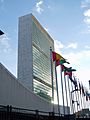
The United Nations Headquarters has been in Midtown Manhattan since 1952.
-
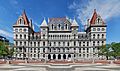
The New York State Capitol in Albany.
-
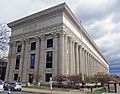
The New York State Education Department Building, Albany.
-
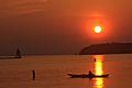
Lake Champlain is popular for nature and water sports.


See also
 In Spanish: New York (desambiguación) para niños
