
New Amsterdam facts for kids
Quick facts for kids
New Amsterdam
Nieuw Amsterdam (Dutch)
|
|||
|---|---|---|---|

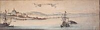
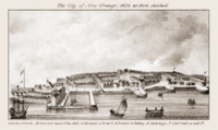
View of New Amsterdam
|
|||
|
|||
| Dutch colony | |||
| Settled | 1624 | ||
| Conquered by the English | 1664 | ||
| Recaptured by the Dutch | 1673 | ||
| Relinquished to the English | 1674 | ||
| Government | |||
| • Type | Colonial government | ||
| • Body | Council of Mayors, Schepen and a Schout | ||
| Area | |||
| • Land | 94 km2 (36.29 sq mi) | ||
| Highest elevation | 122 m (401 ft) | ||
| Lowest elevation | 0 m (0 ft) | ||
| Population | |||
| • Estimate
(1664)
|
2,500 | ||
| • Rank | 1st in New Netherland | ||
| Demonym(s) | New Netherlander | ||
| Time zone | UTC–05:00 (EST) | ||
| • Summer (DST) | UTC–04:00 (EDT) | ||

_1654.png)
_Castello_Plan_1660.jpg)
New Amsterdam (called Nieuw Amsterdam in Dutch) was a Dutch settlement in the 1600s. It was built at the southern tip of Manhattan Island. This settlement was the main city for the Dutch colony of New Netherland. It started as a trading post around Fort Amsterdam. This fort was important for protecting the fur trade of the Dutch West India Company on the North River (now the Hudson River).
In 1624, New Amsterdam became part of the Dutch Republic. By 1625, it was named the capital of the New Netherland province. New Amsterdam officially became a city on February 2, 1653, when it got special city rights.
By 1655, about 1,500 people lived in New Amsterdam. This was out of 2,000 people in all of New Netherland. By 1664, the population of New Amsterdam grew to 2,500 people. The total population of New Netherland was almost 9,000.
In 1664, the English took control of New Amsterdam. They renamed it New York after the Duke of York. After a war between England and the Dutch (the Second Anglo-Dutch War, 1665–67), they signed the Treaty of Breda. The English kept Manhattan Island. The Dutch gave up their claim to the town and the rest of the colony. In return, the English gave up their claims to Surinam in South America and the island of Run in the East Indies. This helped the Dutch keep control of the valuable Spice Islands. The area where New Amsterdam once stood is now Lower Manhattan.
Contents
What's in a Name?
The native Munsee people called the southern tip of the island "Manhattoe." The Dutch settlement there was also called "Amsterdam" or "New Amsterdam." The city limits of New Amsterdam did not go north of the wall that later became Wall Street. The rest of Manhattan Island and New Netherland were not part of the city itself.
History of New Amsterdam
Early Exploration and Settlement (1609–1624)

In 1524, long before the Dutch arrived, an Italian explorer named Giovanni da Verrazzano visited the area. He named it "Nouvelle Angoulême." This was to honor King Francis I of France.
The Dutch first explored the area around what is now New York Bay in 1609. This was when Henry Hudson sailed his ship, the Halve Maen (meaning "Half Moon"), for the Dutch Republic. Hudson named the river the Mauritius River. He was also secretly looking for a shortcut to Asia, called the Northwest Passage. Instead, he found out about the many beavers in the area.
Beaver furs were very valuable in Europe. They were used to make waterproof hats. Also, a substance from beavers called castoreum was used for medicine and perfumes. Dutch explorers like Adriaen Block and Hendrick Christiaensen mapped the region between 1611 and 1614. On their 1614 map, they named the new territory "New Netherland." They also built the first year-round trading post, Fort Nassau. This fort was later replaced by Fort Orange in 1624. Fort Orange eventually grew into the city of Albany.
Juan (Jan) Rodriguez was a trader from the Spanish colony of Santo Domingo. He arrived on Manhattan Island in the winter of 1613–1614. He traded with the local people and trapped beavers. He is known as the first non-Indigenous person to live in what would become New York City.
New Netherland began as a business to make money from trading with local Indigenous peoples. The Dutch Republic planned to officially settle the area, which happened in 1624.
Pilgrims Try to Settle

In 1620, the Pilgrims tried to sail from England to the Hudson River. However, their ship, the Mayflower, reached Cape Cod (in Massachusetts) on November 9, 1620. After 64 days at sea, they were low on supplies. So, the Pilgrims decided to settle near Cape Cod and started the Plymouth Colony.
The Dutch Return
The mouth of the Hudson River was chosen as a good place for a settlement. It had easy access to the ocean and stayed ice-free. This was important for getting furs from the beaver trading post near Albany. Indigenous hunters traded furs for European goods and wampum, which the Dutch soon made on Long Island.
In 1621, the Dutch West India Company was created. Between 1621 and 1623, private traders were told to leave the area. This opened up the land for Dutch settlers and company traders. It also meant that Dutch laws would now apply.
On May 20, 1624, the first Dutch settlers arrived in New Netherland. They came on the ship Nieu Nederlandt to Noten Eylandt (now Governors Island). Thirty families got off the ship to officially claim the New Netherland territory. The Dutch West India Company ordered an engineer, Crijn Fredericxsz, to build Fort Amsterdam. A fort was finished in 1626.
The families were then sent to other places. Some went to Fort Wilhelmus on Verhulsten Island (now Burlington Island) in the South River (now the Delaware River). Others went to Kievitshoek (now Old Saybrook, Connecticut) at the mouth of the Verse River (now the Connecticut River). More went north to Fort Nassau on the Mauritius or North River (now the Hudson River).
A fort and a sawmill were soon built on Nut Island. The sawmill was later taken apart in 1648.
Building Fort Amsterdam (1624)


Other European countries might attack the Dutch colonies. So, the directors of the Dutch West India Company made a plan to protect the entrance to the Hudson River. In 1624, 30 families moved from Nut Island to Manhattan Island. Here, a fort called Fort Amsterdam was being planned by Cryn Frederickz van Lobbrecht. By the end of 1625, the fort's location was set. It was just south of Bowling Green.
A conflict between the Mohawk and Mahican tribes in the Hudson Valley led the company to move even more settlers near the new Fort Amsterdam. Building a colony was very expensive. The fur trade only partly paid for it. So, the original plans for the fort were made smaller. By 1628, a smaller fort was built with walls made of clay and sand.
The fort was also the center for trading. It had a place for soldiers, a church, a house for the company's director, and a warehouse. Soldiers from the fort practiced marching in the area between the Heerestraat and what is now Whitehall Street.
Life in New Amsterdam (1624–1664)
_Drawing_1650-1654.jpg)


Willem Verhulst chose Manhattan as the permanent settlement location and decided where Fort Amsterdam would be. He was replaced by Peter Minuit in 1626. To protect the settlers' land, Minuit bought Manhattan from a group of Canarse people from Brooklyn. They controlled the southern part of Manhattan, called the Manhattoes. Minuit traded goods worth 60 guilders for the land. The Canarse chief, Seyseys, was happy to get valuable goods for land that was mostly controlled by another group, the Weckquaesgeeks.
An official letter from November 7, 1626, by Pieter Schagen, confirmed the purchase of Manhattan Island. The letter said the island was about 94 square kilometers (36.29 square miles). The actual deed for the land has not survived. The value of 60 Dutch guilders in 1626 is about $1,100 in today's money. The story that Manhattan was bought for "twenty-four dollars' worth of trinkets and beads" comes from this transaction.
The Dutch brought windmills to the area. The first was on Noten Eylandt for a sawmill. Later, they used the power of creeks to build mills at Turtle Bay and Harlem Mill Creek. In 1639, a sawmill was built in the northern forest. Here, enslaved Africans cut lumber.
By 1642, New Amsterdam had about 270 people. The new director, Willem Kieft, decided to build a stone church inside the fort. English immigrants, John and Richard Ogden, built the church. It was finished in 1645. The church stood until it was destroyed in a conflict in 1741.
A drawing of New Amsterdam from 1648 was found in 1991. It shows a unique view of the city from Capske Rock. This rock was in the water near Manhattan and marked the start of the East River roadstead.
New Amsterdam officially became a city on February 2, 1653. It received city rights from Governor Peter Stuyvesant. Other nearby towns also got city rights. Albany (then called Beverwyck) got its rights in 1652. Nieuw Haarlem (now Harlem) was recognized in 1658.
The first Dutch Jews arrived in New Amsterdam in 1654. Solomon Pietersen and Jacob Barsimson came directly from Holland with trading permits. In September, 23 Jewish refugees arrived from Recife, Brazil. The director-general, Peter Stuyvesant, wanted to send them away. But the directors of the Dutch West India Company in Amsterdam said they could stay. Asser Levy, one of the refugees, became successful. In 1661, he was the first Jew to own a house in New Amsterdam.
On September 15, 1655, several hundred Munsee people entered New Amsterdam. This may have been because a Dutch colonist killed a woman who was taking peaches from his orchard. There was no fighting until the Munsee were shot at as they were leaving. This led to attacks on Pavonia and Staten Island. Governor Stuyvesant reported that 28 farms were destroyed, 40 people died, and 100 were captured in what became known as the Peach War.
In 1661, the Communipaw ferry started. This began a long history of transportation across the Hudson River.
In 1664, Jan van Bonnel built a sawmill on East 74th Street and the East River. A long stream called the Saw Kill emptied into the river there. Later, the sawmill was replaced by a leather mill in 1677. The Saw Kill stream was later covered over.
-
Novum Amsterodamum 1650, by Laurens Block
-
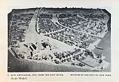
New Amsterdam in 1660, Scale Model
-
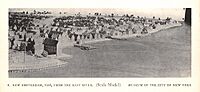
New Amsterdam from the East River in 1660, Scale Model
-
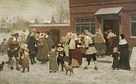
Party For New Year's Day In New Amsterdam 1636 (George Boughton)
-
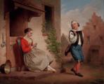
Courtship in New Amsterdam (Fancis W. Edmonds)
_painting_by_Laurens_Block.jpg)

_Museum_of_NYC.jpg)


English Takeover
On August 27, 1664, four English ships sailed into New Amsterdam's harbor. They demanded that New Netherland surrender, even though England and the Dutch Republic were at peace. The Dutch leaders decided not to fight. On September 6, Governor Stuyvesant's lawyer, Johannes de Decker, and five others signed the Articles of Surrender of New Netherland. This led to the Second Anglo-Dutch War. In June 1665, New Amsterdam became part of English law as New York City. It was named after the Duke of York (who later became King James II). He was the brother of King Charles II, who had been given these lands.
In 1667, the Treaty of Breda ended the war. The Dutch did not push to get New Netherland back. Instead, they demanded control over valuable sugar plantations and factories they had captured in Surinam. This gave them full control over the coast of what is now Guyana and Suriname.
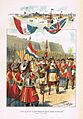
On August 9, 1673, during the Third Anglo-Dutch War, the Dutch quickly took back the colony. They called it "New York" at the time. A combined fleet of Dutch ships recaptured it. Anthony Colve became the first Dutch governor of the province.
When the Dutch took it back, New York City was renamed New Orange. However, after the Treaty of Westminster was signed in February 1674, the Dutch gave the territories back to the English. On November 10, 1674, New Netherland and New Orange went back to being called "New York" and "New York City." Suriname officially became a Dutch possession.
-
The Dutch surrender New Amsterdam in 1664
-
City of New Orange in 1673
_1664_by_Ogden.jpg)
.png)
_1673_sketched.png)
Maps of New Amsterdam

The early days of New Amsterdam were well-documented with detailed city maps. The Dutch were excellent mapmakers in Europe at that time. The Dutch West India Company needed to keep track of the colony's growth. So, they regularly took censuses (counted the population). These tools, along with accurate maps, helped them monitor the province's progress.
One very detailed map is the Castello Plan from 1660. It shows almost every building in New Amsterdam. By using another list from 1660, called the Nicasius de Sille List, we can find out who lived in each house.
Another map, the Duke's Plan, probably came from the same 1660 census. It was made for James, the Duke of York and Albany. New York, New York City, and Albany were named after him after the English took over New Amsterdam.
These old city maps are very helpful for archaeologists in New York City. For example, the Castello map helped find the exact spot of the Stadthuys (City Hall) of New Amsterdam during excavations.
City Layout

The maps allow us to rebuild the town's layout precisely. Fort Amsterdam was at the very southern tip of Manhattan Island, where Bowling Green is today. The Battery gets its name from the fort's cannons.
Broadway was the main street. It led north out of town towards Harlem. A wall surrounded the town to the north, going from the eastern to the western shore. Today, Wall Street follows the path of this old city wall. Nearby, a canal from the harbor was filled in 1676. This area is now Broad Street.
The streets in New Amsterdam were winding, like in a European city. The straight grid pattern, typical of New York City today, only started north of Wall Street, long after the Dutch left. Most of the Financial District is built over New Amsterdam and still has its original street layout.
New Amsterdam's Legacy

The official Seal of New York City now shows 1625 as the founding date of New Amsterdam. Before, it showed 1664, the year the English took over.
Some people thought New Amsterdam was just a messy trading post. But Russell Shorto, an author, believes the city left important cultural marks on New York and the United States.
Much new historical research comes from old, untranslated Dutch documents. These are the colony's administrative records. Since the 1970s, Charles Gehring has been translating these documents. They offer a first-hand look at New Netherland.
Scholars now believe that New Amsterdam was much more like modern New York than previously thought. It had a mix of cultures and a spirit similar to the American Dream from its early years. Writers like Russell Shorto argue that New Amsterdam's big influence on American culture has often been overlooked. This is because of the rivalry between the English (who won) and the Dutch (who were conquered).
The original 17th-century buildings of New Amsterdam are gone. They were destroyed by fires in 1776 and 1835. Only archaeological remains are left. However, the original street plan of New Amsterdam is still mostly there. Also, some houses outside Manhattan from that period still exist.
Preserving and teaching about the unique culture of 17th-century New Amsterdam is still important. In 2009, the National Park Service celebrated the 400th anniversary of Henry Hudson's 1609 voyage with the New Amsterdam Trail.
The Dutch-American historian Hendrik Willem van Loon wrote a book in 1933 called "If the Dutch Had Kept Nieuw Amsterdam." It explored what might have happened if history had been different.
Writer Elizabeth Bear also wrote a series of detective stories called "New Amsterdam." In these stories, the city stayed Dutch until the Napoleonic Wars and kept its name.
One of New York's Broadway theatres is called the New Amsterdam Theatre. The name New Amsterdam is also written on the Manhattan Municipal Building. This remembers the name of the Dutch colony.
Even though no original buildings survived, the style of Dutch Colonial Revival architecture lived on. Many buildings in New York City were built in this style in the 1800s and 1900s. Examples include Wallabout Market in Brooklyn and buildings on South William Street in Manhattan.
-
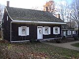
The Wyckoff Farm in Flatbush, Brooklyn. Some parts of it are from the Dutch period of New York City.
-
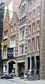
13–15 South William Street, built in the Dutch Colonial Revival style, reminding us of New Amsterdam.

_Manhattan_NYC.jpg)
Images for kids
-
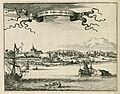
View of New Amsterdam
-

Flag of the Dutch Republic
-
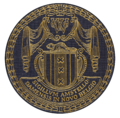
First Seal of New Amsterdam
See also
 In Spanish: Nueva Ámsterdam para niños
