Cape Cod facts for kids
Quick facts for kids Cape Cod |
|
|---|---|
|
|
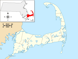
Cape Cod (Barnstable County), in Massachusetts
|
|
| Location | Massachusetts, United States |
| Coordinates | 41°41′N 70°12′W / 41.68°N 70.2°W |
| Offshore water bodies | |
| Elevation | 306 ft (93 m) |
| Area | 339 sq mi (880 km2) |
| Geology | Cape |
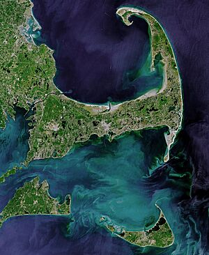
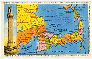
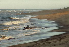
Cape Cod is a cool peninsula that stretches out into the Atlantic Ocean. It's located in the southeastern part of Massachusetts, in the northeastern United States. This area is famous for its long history, connection to the sea, and beautiful beaches. Lots of tourists visit during the summer months. The name Cape Cod was first used in 1602 by Bartholomew Gosnold. It's one of the oldest English place-names in the U.S.
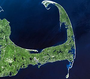
Cape Cod is the same size as Barnstable County, Massachusetts. It goes from Provincetown in the northeast down to Woods Hole in the southwest. Plymouth is to its northwest. Cape Cod is made up of fifteen different towns. Many of these towns have smaller villages inside them. This peninsula also forms the southern edge of the Gulf of Maine. This gulf stretches northeast all the way to Nova Scotia.
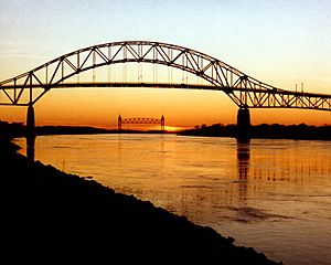
Since 1914, most of Cape Cod has been separated from the mainland. This is because of the Cape Cod Canal. The canal is about 7 miles (11 km) long and cuts across the base of the peninsula. A few small parts of the towns of Bourne and Sandwich are on the mainland side of the canal. Two highway bridges cross the Cape Cod Canal: the Sagamore Bridge and the Bourne Bridge. There's also the Cape Cod Canal Railroad Bridge. This bridge carries trains for both cargo and some passengers onto the Cape.
Contents
Exploring Cape Cod and Nearby Islands
Just like Cape Cod, the islands south of it have changed over time. They used to be important for whaling and trading. Now, they are popular vacation spots. These islands attract many families and visitors. The main islands are Nantucket and Martha's Vineyard.
Both islands are famous summer destinations. You can usually reach them by ferry from different places on Cape Cod. When people say "Cape Cod and the Islands," they mean the whole area. This includes Barnstable County, Dukes County (which has Martha's Vineyard and the smaller Elizabeth Islands), and Nantucket County.
There are also several smaller islands right off Cape Cod. These include Monomoy Island, Monomoscoy Island, Popponesset Island, and Seconsett Island. They are all part of Barnstable County.
Naushon Island is owned by the Forbes family. It's one of the Elizabeth Islands. Many of these islands are privately owned. One Elizabeth Island you can visit is Cuttyhunk Island. It's the southernmost island in the chain and has about 52 people living there all year. Many famous families have homes on the larger islands. This makes them some of the wealthiest vacation spots in the Northeast. But they still keep a lot of their old trading and whaling culture.
Cape Cod is a popular place for people to retire. About 31.8% of the people in Barnstable County are 65 or older. The average age of people living here is the highest in all of New England.
How Cape Cod Was Formed
"East of America, there stands in the open Atlantic the last fragment of an ancient and vanished land. Worn by the breakers and the rains, and disintegrated by the wind, it still stands bold."
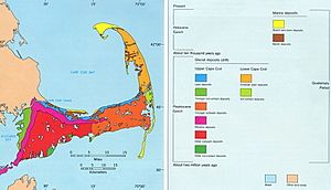
Most of the land on Cape Cod was shaped by glaciers. These huge ice sheets left behind piles of rock and sand. This area was the southernmost point reached by glaciers in southeast New England. Similar landforms make up Long Island in New York and Block Island in Rhode Island. Geologists say Cape Cod is quite young. It was formed about 16,000 to 20,000 years ago.
Cape Cod's history is mostly about the movement of the Laurentide Ice Sheet. This happened during the late Pleistocene ice age. As the ice sheet melted, sea levels changed. Around 23,000 years ago, the ice sheet was at its biggest. Then, it started to melt and move back. Many clear, cold lakes called kettle ponds were formed by the melting glacier. These ponds are still on Cape Cod today. By about 18,000 years ago, the ice sheet had moved past Cape Cod.
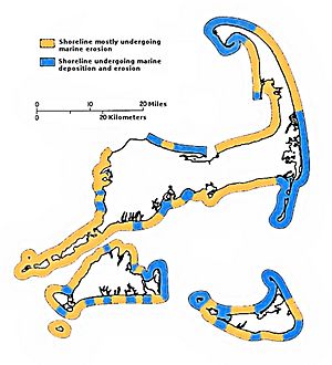
As the ice melted, the sea level began to rise. At first, it rose quickly. Then, it slowed down. On Cape Cod, the sea level rose about 3 metres (9.8 ft) every 1,000 years between 6,000 and 2,000 years ago. After that, it rose about 1 metre (3.3 ft) per 1,000 years. By 6,000 years ago, the sea was high enough to start wearing away the land left by the glaciers. The water moved this sand and dirt north and south along the outer Cape's shoreline. This process is called longshore drift.
The sand that moved north went to the very tip of Cape Cod. The entire town of Provincetown is a spit. It's mostly made of sand that was moved from further south. The sand that moved south created the islands and sandbars of Monomoy. So, while some parts of the Cape have shrunk due to waves, other parts have grown from this sand being deposited. This has happened in just the last 6,000 years.
This process is still happening today. Because Cape Cod and the islands face the open ocean, they experience a lot of coastal erosion. This means the land is slowly being worn away by the sea. Beaches can wash away, and barrier islands can be destroyed. For example, the ocean broke through a barrier island at Chatham during Hurricane Bob in 1991. This allowed big waves to hit the coast directly. The sand from the beaches is washed away and deposited somewhere else. While this destroys land in some places, it builds up land in others, like in marshes.
Cape Cod gets its drinking water from underground water sources called aquifers. There are six separate areas of water under the Cape. Pollution from chemicals and medicines is a concern. In 2023, the state started new rules to control nitrogen pollution. This helps stop too much algae and plants from growing in the water.
Weather on Cape Cod
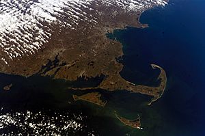
Under the Köppen climate classification, Cape Cod has an oceanic climate. This means it has milder weather than places further inland in New England. The ocean on three sides keeps temperatures a bit cooler in summer. It also keeps them warmer in winter compared to the mainland. Sometimes, big storms like the Blizzard of 2005 or Hurricane Bob hit the Cape hard.
Two ocean currents, the warm Gulf Stream and the cold Labrador Current, meet and mix here. Because of this, the ocean water on the eastern shore of Cape Cod rarely gets above 60 °F (16 °C). But along the southern coast (Nantucket Sound), water temperatures can reach 70 °F (21 °C) or even higher.
The water around Cape Cod makes winter temperatures mild enough for some plants. These plants usually grow in warmer, subtropical areas. You can find Camellias and Magnolia grandiflora growing here. However, Cape Cod's warmest month, July, averages around 68.25 °F (20.14 °C).
Cape Cod's spring season starts later because the sea stays cold from winter. But in the fall, the heat stored in the sea keeps temperatures milder. The highest temperature ever recorded in Provincetown was 104 °F (40 °C). The lowest temperature recorded in Barnstable was −12 °F (−24 °C).
Cape Cod and the islands get less rain than other parts of southern New England. They average just under 40 inches (100 cm) a year. This is because the ocean stops summer thunderstorms from forming. However, the area doesn't have more sunny days. It has the same number of cloudy days as inland places, plus more fog. On average, about 27 inches (69 cm) of snow falls in a winter. This is about 17 inches (43 cm) less than Boston.
About every five or six years, a tropical storm hits the region. These storms bring very strong winds and heavy rain. About once every 11 or 12 years, a hurricane brings damaging winds and storm surges. Several strong hurricanes have hit Cape Cod. These include storms in 1869, the 1938 New England hurricane, and Hurricane Carol in 1954. Strong Category 2 storms, like Hurricane Edna in 1954 and Hurricane Bob in 1991, also caused a lot of damage. The "Perfect Storm" in October 1991 was also very notable. A big winter storm in February 2013 brought winds over 80 miles per hour (130 km/h) and more than 24 inches (61 cm) of snow. It knocked out power for many people, some for up to two weeks.
| Climate data for Cape Cod (Chatham, Massachusetts) | |||||||||||||
|---|---|---|---|---|---|---|---|---|---|---|---|---|---|
| Month | Jan | Feb | Mar | Apr | May | Jun | Jul | Aug | Sep | Oct | Nov | Dec | Year |
| Record high °F (°C) | 61 (16) |
57 (14) |
77 (25) |
81 (27) |
88 (31) |
90 (32) |
95 (35) |
93 (34) |
85 (29) |
82 (28) |
68 (20) |
69 (21) |
95 (35) |
| Mean daily maximum °F (°C) | 37.6 (3.1) |
38.3 (3.5) |
42.8 (6.0) |
50.5 (10.3) |
59.0 (15.0) |
68.4 (20.2) |
74.9 (23.8) |
74.7 (23.7) |
69.4 (20.8) |
60.0 (15.6) |
51.7 (10.9) |
42.8 (6.0) |
55.9 (13.3) |
| Daily mean °F (°C) | 30.9 (−0.6) |
31.7 (−0.2) |
36.7 (2.6) |
45.1 (7.3) |
53.6 (12.0) |
62.6 (17.0) |
68.8 (20.4) |
68.7 (20.4) |
63.6 (17.6) |
53.9 (12.2) |
45.6 (7.6) |
36.5 (2.5) |
49.9 (9.9) |
| Mean daily minimum °F (°C) | 24.1 (−4.4) |
25.0 (−3.9) |
30.7 (−0.7) |
39.6 (4.2) |
48.1 (8.9) |
56.7 (13.7) |
62.7 (17.1) |
62.6 (17.0) |
57.7 (14.3) |
47.8 (8.8) |
39.6 (4.2) |
30.2 (−1.0) |
43.8 (6.6) |
| Record low °F (°C) | −6 (−21) |
−4 (−20) |
7 (−14) |
19 (−7) |
33 (1) |
44 (7) |
51 (11) |
47 (8) |
40 (4) |
31 (−1) |
19 (−7) |
0 (−18) |
−6 (−21) |
| Average precipitation inches (mm) | 3.83 (97) |
4.24 (108) |
4.85 (123) |
4.14 (105) |
3.81 (97) |
3.41 (87) |
3.28 (83) |
3.20 (81) |
3.83 (97) |
4.04 (103) |
4.03 (102) |
4.38 (111) |
47.04 (1,195) |
| Average snowfall inches (cm) | 8.2 (21) |
10.3 (26) |
3.5 (8.9) |
0.6 (1.5) |
0 (0) |
0 (0) |
0 (0) |
0 (0) |
0 (0) |
0 (0) |
0.4 (1.0) |
3.6 (9.1) |
26.6 (68) |
| Average precipitation days (≥ 0.01 in) | 12 | 10 | 12 | 11 | 11 | 9 | 8 | 8 | 9 | 10 | 11 | 13 | 125 |
| Source 1: Western Regional Climate Center (normals 1981–2010, extremes and snow 1972–present) | |||||||||||||
| Source 2: NOAA | |||||||||||||
History of Cape Cod
Wampanoag People
Cape Cod was originally home to the Native American Wampanoag people for many centuries. They lived off the sea and were also skilled farmers. They knew how to manage forests in a way that kept them healthy. They even used controlled fires to clear out underbrush. The Wampanoag helped the Pilgrims survive when they arrived in 1620.
Over time, the Wampanoag slowly lost their lands. This happened because Europeans moved in and there were conflicts. A documentary called Natives of the Narrowland (1993) tells the story of the Wampanoag. It uses archaeological sites on Cape Cod to show their history.
In 1974, the Mashpee Wampanoag Tribal Council was formed. They worked to represent people with Native American ancestry. In May 2007, the Mashpee Wampanoag tribe was officially recognized by the U.S. government.
Early European Explorers
Cape Cod was an important landmark for early explorers. Some people think it might have been the "Promontory of Vinland" mentioned by Norse travelers around 985–1025 AD. However, this idea is debated. There is no strong proof that Norse voyagers were on Cape Cod. Most archaeologists and historians do not believe it.
Giovanni da Verrazzano sailed near Cape Cod from the south in 1524. He named Martha's Vineyard "Claudia." In 1525, Portuguese explorer Estêvão Gomes called it "Cabo de la Arenas."
In 1602, Bartholomew Gosnold gave the tip of the land the name Cape Cod. This name stuck and is the ninth oldest English place-name in the U.S. Samuel de Champlain mapped its sandy harbors in 1606. Henry Hudson landed there in 1609. Captain John Smith included it on his map in 1614. Finally, the Pilgrims arrived in "Cape Harbor" and landed near Provincetown on November 11, 1620. They first met the Native Americans in nearby Eastham.
European Settlement and Changes
Cape Cod was one of the first places settled by Puritan colonists in North America. The Cape's fifteen towns grew slowly. Barnstable (1639), Sandwich (1637), and Yarmouth (1639) were among the first. The last town to be created on the Cape was Bourne in 1884. Provincetown was just a few huts until the 1700s. The Cape Cod Canal was built between 1870 and 1914. The government bought it in 1928.
Because of early settlement and farming, Cape Cod had very few trees by the mid-1800s. Settlers used a lot of wood for heating their homes. They cleared most of the timber early on. They tried to grow familiar crops, but the thin, glacial soil wasn't good for them. For example, much of Eastham was planted with wheat. Farmers also burned woodlands to add nutrients to the soil. But improper farming led to erosion and the loss of topsoil. Farmers let their cattle graze on the grassy dunes. They watched as the bare sands "walked" over richer lands, burying fields. Sand dunes became more common, and many harbors filled with eroded soil.
By 1800, most of Cape Cod's firewood had to be brought in by boat from Maine. The lack of plants got worse when many sheep were raised around 1840. The early Industrial Revolution happened in much of Massachusetts, but it mostly skipped Cape Cod. This was because there wasn't much waterpower for factories. Instead, the Cape became a big fishing and whaling center. This was also due to its location. After 1860, farmers stopped farming on the Cape. By 1950, forests had grown back to a level not seen since the 1700s.
Modern Times
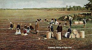
Cape Cod became a popular summer getaway for city people in the late 1800s. Better train travel made towns like Bourne and Falmouth easy to reach from Boston. In the early 1900s, wealthy families built large "cottages" along Buzzards Bay. Writers like Joseph C. Lincoln wrote stories about Cape Cod life.
Guglielmo Marconi sent the first transatlantic wireless message from the United States from Cape Cod. This happened in Wellfleet. The beach below his station is now called Marconi Beach. In 1914, he started building a new radio station in Chatham. This station was used to talk to ships at sea. It helped with communications for famous people like Amelia Earhart and Howard Hughes. Marconi chose Chatham because it was surrounded by water and had a good view of the Atlantic Ocean.
Much of Cape Cod's Atlantic coastline has wide, sandy beaches. In 1961, President John F. Kennedy made a large part of this coast the Cape Cod National Seashore. This protected it from private building and kept it open for everyone to enjoy. Many parts are open to the public, including the Marconi Site in Wellfleet. This park includes the spot of the first two-way radio message across the ocean from the U.S.
The Kennedy Compound in Hyannis Port was President Kennedy's summer home. The Kennedy family still has homes there. President Grover Cleveland also had a summer home in Bourne. Many other famous people have lived on Cape Cod. These include actress Julie Harris and writers Norman Mailer and Kurt Vonnegut.
Lighthouses of Cape Cod
"Lighthouses, from ancient times, have fascinated members of the human race. There is something about a lighted beacon that suggests hope and trust and appeals to the better instincts of mankind."
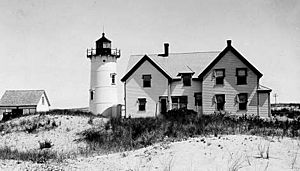
Lighthouses were built along Cape Cod starting in 1797. They helped ships navigate safely. Highland Light (also called Cape Cod Light) is the oldest and tallest. It is still one of many working lighthouses on Cape Cod and the Islands. Many early lighthouses on Cape Cod had the light tower built right on top of the keeper's house. This was known as a Cape Cod style lighthouse.
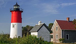
Most of Cape Cod's lighthouses are run by the U.S. Coast Guard. But some are different. For example, the Nauset Light is owned by the Cape Cod National Seashore. It's run in partnership with a non-profit group.
In 1996, both Highland Light and Nauset Light had to be moved. They were too close to the shore and at risk of falling into the sea due to erosion. Highland Light was moved 450 ft (140 m) to the west. Nauset Light was moved 300 ft (91 m) west.
Here are some of the lighthouses on Cape Cod:
- Upper Cape: Nobska Light, Wing's Neck Light, and Cleveland Ledge Light.
- Mid Cape: Sandy Neck Light, Hyannis Harbor Light, Lewis Bay Light, and West Dennis Light.
- Lower Cape: Chatham Light, Monomoy Point Light, and Stage Harbor Light.
- Outer Cape: Long Point Light, Wood End Light, Race Point Light, Highland Light, Nauset Light, Three Sisters of Nauset, Mayo Beach Light, and Billingsgate Island Light.
Getting Around Cape Cod
By Road
Cape Cod is connected to the mainland by two highway bridges. These are the Bourne and Sagamore bridges. They were built in the 1930s. The two bridges are four miles apart. The Bourne Bridge is to the west, and the Sagamore is to the east. These bridges can get very crowded during the summer. Traffic jams often happen when tourists arrive or leave for the weekend.
The main road that runs through the middle of the Cape is U.S. Route 6. It's also known as the Mid-Cape Highway.
By Air
You can fly to Cape Cod using commercial flights from Cape Cod Gateway Airport and Provincetown Municipal Airport. There are also smaller airports for private planes:
- Chatham Municipal Airport
- Falmouth Airpark
- Cape Cod Airfield in Marstons Mills, Barnstable
There is one military airport at Otis Air National Guard Base. The closest big airports are Logan International Airport in Boston and Rhode Island T. F. Green International Airport.
By Ferry
Ferries run from Falmouth and Hyannis to the islands of Nantucket and Martha's Vineyard. There's also ferry service between New Bedford and Martha's Vineyard. More ferry services run during the summer. You can also take a seasonal ferry between Boston and Provincetown.
By Bus
The Cape Cod Regional Transit Authority runs a public bus system all year round. It serves all 15 towns on Cape Cod. From mid-June to October, more local bus routes are added. This bus system also provides special services for people with disabilities.
Long-distance bus service is available from Plymouth & Brockton and Peter Pan Bus. They have regular service to Boston and some service to Provincetown. Peter Pan Bus Lines also goes to Providence, Rhode Island, and New York City.
By Train
The third bridge over the Cape Cod Canal is a railroad bridge. It lifts up to let boats pass. After the bridge, the train tracks split. One goes towards Hyannis and the other towards North Falmouth. The track to Hyannis is used for both cargo and passengers. The Falmouth track is mostly for cargo.
Passenger Trains
The CapeFlyer is a seasonal passenger train service. It runs between Boston and Hyannis on summer weekends. It operates from Memorial Day to Labor Day. Stops on or near the Cape include Buzzards Bay, Bourne, and Hyannis.
The Cape Cod Central Railroad is a special train for tourists. It offers a dinner train ride between Hyannis and the Cape Cod Canal. This scenic trip lasts about 2.5 hours. Some trains also stop at West Barnstable and Sandwich.
Freight Trains
Freight trains still run in the Upper Cape. They use the main line from Bourne to Hyannis and a side track to North Falmouth. One common cargo is trash. It's taken to a plant in Rochester that turns waste into energy. The Massachusetts Coastal Railroad operates freight trains on the Cape.
Historic Train Service
Daily passenger train service from Boston to Cape Cod ended in 1959. Summer train service from New York City to the Cape ended in 1964. In 1978, some tracks were removed and turned into the Cape Cod Rail Trail for bikes. Another bike path, the Shining Sea Bikeway, was built over old tracks in 1975.
From 1986 to 1996, Amtrak ran a seasonal train called the Cape Codder from New York City to Hyannis. This service ended in 1996. The current CapeFlyer service started in 2013.
By Bicycle
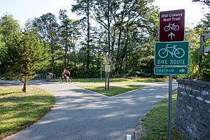
You can bike or walk onto Cape Cod using a sidewalk on the Bourne Bridge. There are many special bike trails and paths around the Cape:
- Cape Cod Rail Trail - from South Dennis to Wellfleet
- Old Colony Rail Trail - in Harwich and Chatham, connects to the Cape Cod Rail Trail
- Various trails in the Cape Cod National Seashore
- Various trails in Nickerson State Park, connecting to the Cape Cod Rail Trail
- Shining Sea Bikeway - from Woods Hole to North Falmouth
- Cape Cod Canal path on both sides of the canal
- Various unpaved Mid-Cape trails
For longer bike rides, the Claire Saltonstall Bikeway connects Cape Cod to Boston.
Tourism on Cape Cod
Cape Cod has about 220,000 people living there all year. But it gets many more visitors during the summer tourist season. This season usually starts around Memorial Day and ends around Labor Day. Many businesses focus on summer visitors. However, more people are visiting in the spring and fall now. This means the "off-season" is getting shorter.
Provincetown is home to the first East Coast whale watching fleet. They go out to the Stellwagen Bank National Marine Sanctuary. They guarantee you'll see whales like humpback whales, fin whales, and North Atlantic right whales. Provincetown is also known as an art colony. It attracts many writers and artists. The town has the Provincetown Art Association and Museum, which is the most visited art museum on the Cape.
Cape Cod is a popular place for beach lovers. It has 559.6 miles (900.6 km) of coastline. There are many public and private beaches that are easy to get to. The Cape has over sixty public beaches. Many offer parking for a daily fee in the summer. The Cape Cod National Seashore has 40 miles (64 km) of sandy beach and many walking paths.
Cape Cod is also great for outdoor activities. You can go beach walking, biking, boating, fishing, golfing, kayaking, and miniature golf. There are 27 public golf courses and 15 private courses on Cape Cod. Many visitors stay in Bed and breakfasts or vacation houses.
Each summer, the Naukabout Music Festival is held in East Falmouth. It usually happens during the first weekend of August. The festival features local and national music, food, art, and family activities. Some well-known Cape products are cranberries, shellfish (like oysters and clams), and lobsters.
Sport Fishing
Cape Cod is famous around the world for sport fishing from spring to fall. Popular fish to catch include striped bass, bluefish, bluefin tuna, and bonito. The Cape Cod Bay side of the Cape has many harbors and shallow areas. These spots attract bait fish and larger game fish.
The outer edge of the Cape faces the open Atlantic. The bays and harbors along this coast are good places for game fish. In late summer, warmer-water fish like mahi-mahi and marlin can also be found. Almost every harbor on Cape Cod has boats you can charter for fishing trips. These run from May through October.
One of the most popular fishing spots on the East Coast is the Cape Cod Canal. Many anglers come from far away to catch striped bass there. It's easy to access, with plenty of free parking. This makes fishing simple – all you need is a pole and some lures.
Sports on Cape Cod
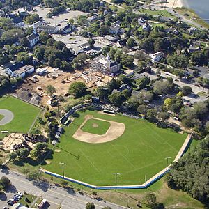
Cape Cod has nine amateur baseball teams in Barnstable County. These teams play in the Cape Cod Baseball League. The Wareham Gatemen also play in this league. The league started in 1923 with four teams. It became a league for college players in 1963. The current teams include the Bourne Braves, Brewster Whitecaps, Chatham Anglers, Cotuit Kettleers, Falmouth Commodores, Harwich Mariners, Hyannis Harbor Hawks, Orleans Firebirds, Wareham Gatemen, and Yarmouth–Dennis Red Sox. MLB scouts often watch these games to find future stars.
Many high school players from the Cape are also being recruited for college sports. Barnstable and Harwich high schools have sent many baseball players to Division 1 colleges. Harwich has won three state baseball titles since 1996. Bourne and Sandwich are rivals in hockey. Bourne won a state championship in 2004, and Sandwich won in 2007. Barnstable and Falmouth have one of the longest Thanksgiving football rivalries in the country. They have played each other every Thanksgiving since 1895.
In 2011, four high school football teams from the Cape won state championships. These were Dennis-Yarmouth, Bourne, Mashpee, and Nantucket/Upper Cape Cod Tech. The Bourne and Barnstable girls' volleyball teams are among the best in the state. Barnstable has won 12 state titles in the past 13 years.
The end of each summer is marked by the Falmouth Road Race. It's held on the third Saturday in August. About 10,000 runners come to the Cape for this race. It attracts some of the best runners in the world. The race is 7.0 miles (11.3 km) long. It starts at a bar in Woods Hole and finishes at the beach in Falmouth Heights. Before the Falmouth race, there's a 5-mile (8.0 km) race in Brewster called the Brew Run.
Education on Cape Cod
Every town on Cape Cod has elementary, middle, and high schools. Some schools serve more than one town. For example, Dennis-Yarmouth Regional High School serves Yarmouth and Dennis. Monomoy Regional High School serves Harwich and Chatham. Nauset Regional High School serves Brewster, Orleans, Eastham, Wellfleet, Truro, and Provincetown.
Barnstable High School is the largest high school on the Cape. Sturgis Charter Public School in Hyannis is a public charter school. Students from the Cape and nearby areas can attend. The Cape also has two vocational high schools. These are the Cape Cod Regional Technical High School in Harwich and Upper Cape Cod Regional Technical High School in Bourne.
In 1976, Cape schools created the Cape Cod Collaborative. This group helps schools work together. It provides programs for gifted students and students with special needs. The Collaborative offers transportation, training, and other services. Each summer, it runs a science program for gifted students with the Massachusetts Maritime Academy.
Mashpee High School has the world's first high school chapter of the SMPTE. This is the Society of Motion Picture and Television Engineers.
Besides public schools, Cape Cod has many private schools. Barnstable has Trinity Christian Academy, Cape Cod Academy, St. Francis Xavier Preparatory School, and Saint John Paul II High School. Sandwich has the Waldorf School of Cape Cod. Harwich has the Lighthouse Charter School. Falmouth has Falmouth Academy. Riverview School in East Sandwich is a special boarding school for students with learning disabilities.
Cape Cod has three colleges. One is Cape Cod Community College in West Barnstable. The second is Massachusetts Maritime Academy in Buzzards Bay. This is the oldest maritime college in the United States. The third is Bridgewater State University. It opened a campus in South Yarmouth in 2015. This campus offers courses for bachelor's and master's degrees.
Cape Cod in Pop Culture and Art
Famous writer and philosopher Henry David Thoreau wrote about his trip to the Cape in 1849. His book Cape Cod was published in 1865.
The Cape Codder cocktail is named after the peninsula. Both are known for cranberries. Cape Cod also inspired a special style of house, called a Cape style house, and a Cape lighthouse.
Artist Edward Hopper had a summer house in Truro. He painted many scenes of the Cape. These include Corn Hill (1930) and Highland Light, North Truro (1930).
The popular song "Old Cape Cod" sung by Patti Page in 1957 praises Cape Cod as a great place to visit.
In 1996, Massachusetts started making special "Cape & Islands" license plates.
|
See also
 In Spanish: Cabo Cod para niños
 | Toni Morrison |
 | Barack Obama |
 | Martin Luther King Jr. |
 | Ralph Bunche |


