
Barnstable County, Massachusetts facts for kids
Quick facts for kids
Barnstable County
|
|||
|---|---|---|---|
   .jpg) Images, from top down, left to right: Nauset Light in Eastham; View of the Kennedy Compound; The Bourne Bridge; Boat off of Chatham
|
|||
|
|||

Location within the U.S. state of Massachusetts
|
|||
 Massachusetts's location within the U.S. |
|||
| Country | |||
| State | |||
| Founded | June 2, 1685 | ||
| Named for | Town of Barnstable | ||
| Seat | Barnstable | ||
| Largest city | Barnstable | ||
| Area | |||
| • Total | 1,306 sq mi (3,380 km2) | ||
| • Land | 394 sq mi (1,020 km2) | ||
| • Water | 912 sq mi (2,360 km2) 70%% | ||
| Population
(2020)
|
|||
| • Total | 228,996 | ||
| • Density | 580.9/sq mi (224.3/km2) | ||
| Time zone | UTC−5 (Eastern) | ||
| • Summer (DST) | UTC−4 (EDT) | ||
| Congressional district | 9th | ||


Barnstable County is a special area called a county in the state of Massachusetts, USA. In 2020, about 228,996 people lived here. The main town, or county seat, is Barnstable. This county covers most of Cape Cod and some nearby islands. (Other islands are in Dukes County and Nantucket County.)
Barnstable County was first created on June 2, 1685. It was part of the Plymouth Colony. It included towns like Falmouth and Sandwich. Later, in 1691, Plymouth Colony joined with the Province of Massachusetts Bay.
Contents
History of Barnstable County
Who first explored Cape Cod?
Early explorers visited the area that is now Barnstable County. One of the first was an Italian explorer named Giovanni da Verrazzano. He sailed for the King of France in 1524. Verrazzano wrote about a large sandy area that stretched far into the sea. This was likely the Nantucket Shoals near Cape Cod. He also described a "promontory," which was probably Cape Cod itself.
Bartholomew Gosnold's visit
In 1602, an English explorer named Bartholomew Gosnold sailed to the New World. He planned to set up a trading post. His ship, the Concord, reached the coast of Maine. Then they sailed south and found what looked like an island. They anchored in Provincetown Harbor.
Gosnold first called the land "Shoal Hope." But he soon realized it was a cape. He also found many cod fish in Cape Cod Bay. So, he changed the name to Cape Cod.
Gosnold met the Nauset Tribe, who lived there. They were friendly and related to the Wampanoag people. Gosnold noted how healthy they seemed. He then explored more, finding an island full of plants and birds. He named it Martha's Vineyard after his daughter. Another island, Cuttyhunk Island, he named Elizabeth Island. This was to honor Elizabeth I of England. The Elizabeth Islands are named after her.
Gosnold wanted to build a trading post on Cuttyhunk Island. But the colonists decided not to stay. Gosnold later returned to America in 1608. He was part of the Jamestown expedition. He sadly died there from malaria.
Martin Pring's expedition
Another English expedition came in 1603. It was led by a young captain named Martin Pring. He had permission from Sir Walter Raleigh to explore North America. Pring sailed in two ships, the Speedwell and the Discoverer.
Geography of Barnstable County
Barnstable County covers a total area of about 1,306 square miles (3,380 km²). Most of this area, about 912 square miles (2,360 km²), is water. Only 394 square miles (1,020 km²) is land. This makes it the second-largest county in Massachusetts by total area. It has about 550 miles (890 km) of shoreline.
It's important to know that Barnstable County is not exactly the same as Cape Cod. Cape Cod is a natural landform, a long peninsula. Barnstable County is a legal area defined by its borders. These borders include all the cities and towns that are part of the county. The main difference is the water area that extends from the coast.
The highest point in the county is Pine Hill. It is 306 feet (93 meters) high. The lowest point is sea level.
Neighboring areas
Barnstable County shares a border with Plymouth County to the northwest. To the south, across the water, are Dukes County and Nantucket County.
Protected natural areas
Barnstable County is home to several important natural areas:
Population and People
Barnstable County is known for having many older residents. It ranks among the top ten counties in the U.S. for highest median age. In 2020, the average age was 55 years old. This is much older than the U.S. average of 39 years old. It is the only county in the Northeast with such an old average age.

| Historical population | |||
|---|---|---|---|
| Census | Pop. | %± | |
| 1790 | 17,342 | — | |
| 1800 | 19,293 | 11.3% | |
| 1810 | 22,211 | 15.1% | |
| 1820 | 24,026 | 8.2% | |
| 1830 | 28,514 | 18.7% | |
| 1840 | 32,548 | 14.1% | |
| 1850 | 35,276 | 8.4% | |
| 1860 | 35,990 | 2.0% | |
| 1870 | 32,774 | −8.9% | |
| 1880 | 31,897 | −2.7% | |
| 1890 | 29,172 | −8.5% | |
| 1900 | 27,826 | −4.6% | |
| 1910 | 27,542 | −1.0% | |
| 1920 | 26,670 | −3.2% | |
| 1930 | 32,305 | 21.1% | |
| 1940 | 37,295 | 15.4% | |
| 1950 | 46,805 | 25.5% | |
| 1960 | 70,286 | 50.2% | |
| 1970 | 96,656 | 37.5% | |
| 1980 | 147,925 | 53.0% | |
| 1990 | 186,605 | 26.1% | |
| 2000 | 222,230 | 19.1% | |
| 2010 | 215,888 | −2.9% | |
| 2020 | 228,996 | 6.1% | |
| 2023 (est.) | 231,735 | 7.3% | |
| U.S. Decennial Census 1790–1960 1900–1990 1990–2000 2010–2020 |
|||
What was the population in 2010?
In 2010, there were 215,888 people living in Barnstable County. There were 95,755 households. About 92.7% of the people were white. About 1.9% were Black or African American. About 1.1% were Asian. People of Hispanic or Latino origin made up 2.2% of the population.
Many people had Irish (27.0%), English (19.2%), or Italian (11.4%) backgrounds. The average age was 49.9 years old. The average household had 2.21 people.
Towns and Villages
Barnstable County has one city and many towns and villages. Cities and towns are official legal areas. Villages are smaller parts within these cities or towns. They don't have their own separate governments.
City
- Barnstable (this is the county seat)
Towns
Villages
Education
Barnstable County has many school districts. These districts manage the schools in different towns.
Some districts teach students from kindergarten all the way through 12th grade:
- Barnstable School District
- Bourne School District
- Dennis-Yarmouth School District
- Falmouth School District
- Mashpee School District
- Monomoy Regional School District
- Provincetown School District (Provincetown High School closed in 2013)
- Sandwich School District
Other districts focus on specific age groups:
- Nauset School District (Secondary schools)
- Brewster School District (Elementary schools)
- Eastham School District (Elementary schools)
- Orleans School District (Elementary schools)
- Truro School District (Elementary schools)
- Wellfleet School District (Elementary schools)
Students from Truro can go to Nauset Regional High School.
Cape Cod Community College is also located in the county.
Economy
Barnstable County is well-known for its aquaculture. This means farming seafood like oysters and clams. The county earns the most money from aquaculture products in the entire state.
Images for kids
-
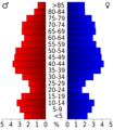
Age breakdown of residents in 2000
-
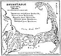
Towns of Barnstable County, historical map of 1890


See also
 In Spanish: Condado de Barnstable para niños
