Elizabeth Islands facts for kids

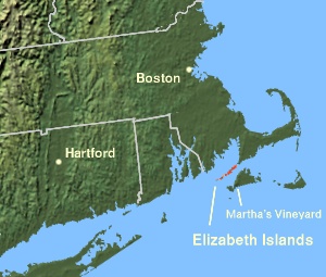
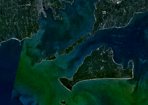
The Elizabeth Islands and Martha's Vineyard, off the coast of Massachusetts
|
|
| Geography | |
|---|---|
| Location | Dukes County, Massachusetts |
| Coordinates | 41°28′30″N 70°46′0″W / 41.47500°N 70.76667°W |
| Archipelago | Elizabeth Islands |
| Area | 13.34 sq mi (34.6 km2) |
| Administration | |
|
United States
|
|
| State | Massachusetts |
| County | Dukes |
| Largest settlement | Village of Cuttyhunk (pop. 52) |
| Demographics | |
| Population | 75 (2010) |
The Elizabeth Islands are a chain of small islands in Massachusetts, United States. They stretch southwest from the southern coast of Cape Cod. These islands are located at the outer edge of Buzzards Bay, north of Martha's Vineyard. They are separated from Martha's Vineyard by Vineyard Sound. Together, these islands form the town of Gosnold in Dukes County, Massachusetts.
Contents
History of the Elizabeth Islands

In 1602, an English explorer named Bartholomew Gosnold was the first European to see these islands. He was on his way to Virginia. Later, in 1641, English settlers officially claimed the islands. They were claimed for the English Crown as part of England's growing empire. The islands were renamed after Elizabeth I, who was Queen of England when they were first discovered.
In 1641, Thomas Mayhew the Elder bought the islands. He also bought Nantucket and Martha's Vineyard from William Alexander. Before 1691, the islands were part of Dukes County, New York. The first known European to live there was Francis Usselton. He had been sent away from other areas for trading secretly with local Native Americans.
Geography and Population
The Elizabeth Islands have a total land area of about 34.55 square kilometers (13.34 square miles). In 2010, the permanent population was 75 people. This makes Gosnold, the town that includes these islands, the smallest town in Massachusetts.
Main Islands of the Elizabeth Chain
Most of the Elizabeth Islands are privately owned by the Forbes family. However, Cuttyhunk and Penikese are not. The islands stretch southwest from Falmouth, Massachusetts.
Here are some of the islands:
- Nonamesset Island: This island is the closest to the mainland.
- Veckatimest: A small island in the chain.
- Gull Island: A small island where no one lives.
- Uncatena Island: No one lived on this island during the 2000 Census.
- Naushon Island: This is the largest island, about 5.5 miles (8.9 km) long. It includes smaller islands like Nonamesset, Monohansett, Bull, Cedar, and Bachelor islands. The Forbes family owns Naushon Island. It is usually not open to the public. However, parts like Tarpaulin Cove, Kettle Cove, Bull Island, and Hadley Harbor are open for public enjoyment, including picnics.
- The Weepecket Islands: These are three small islands north of Naushon. They are owned by the Forbes family but are open to the public. They are often covered by water and are home to many birds, seals, and other animals.
- Pasque Island: This island is about 1.5 miles (2.4 km) long. It is owned by a part of the Forbes family. A shallow tidal creek cuts through the island.
- Nashawena Island: This island is about 3 miles (4.8 km) long. It is owned by another part of the Forbes family and has grazing livestock.
- Baret Island: Located off the north shore of Nashawena Island.
- Rock Island: Also located off the north shore of Nashawena Island.
- Penikese Island: This island is about 0.5 miles (0.8 km) north of Nashawena and Cuttyhunk. The Commonwealth of Massachusetts owns Penikese. It has a rich history. It was once a research center and later a place for people with leprosy. Today, it is a bird sanctuary and home to the Penikese Island School for troubled teens.
- Cuttyhunk Island: This is the farthest west island in the chain. Most of Gosnold's population lives here. Like Penikese, it is not owned by the Forbes family, so much of it is open to the public.
- Gosnold Island: This small island is located in Westend Pond on Cuttyhunk Island.
Water Channels Between Islands
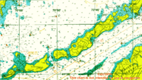
| The Elizabeth Islands |
|---|
 |
| Major Islands listed in order from east to west |
| Nonamesset Uncatena Naushon Pasque Nashawena Penikese Cuttyhunk |
| Minor Islands: |
| Bachelor Baret Bull Cedar Gosnold Gull Rock Veckatimest Weepecket Islands |
Strong water currents, called holes by locals, flow between the islands and the mainland. These currents can be very fast, up to 6 knots (11 km/h). They are caused by the different water levels in Vineyard Sound and Buzzards Bay. At high tide, water flows from Buzzards Bay to Vineyard Sound. Near mid-tide, the water flow stops and then reverses.
Here are the main channels, listed from northeast to southwest:
- Woods Hole: This channel separates the mainland from Nonamesset Island.
- Robinson's Hole: Located between Naushon Island and Pasque Island.
- Quick's Hole: Found between Pasque Island and Nashawena Island.
- Canapitsit Channel: This channel is between Nashawena Island and Cuttyhunk Island.
Harbors and Coves
- Cuttyhunk Harbor: This harbor is protected by Nashawena Island to the east, Cuttyhunk Island to the west, and Penikese Island to the north.
- Tarpaulin Cove: Located on the south shore of Naushon Island.
 | Ernest Everett Just |
 | Mary Jackson |
 | Emmett Chappelle |
 | Marie Maynard Daly |


