
Harwich, Massachusetts facts for kids
Quick facts for kids
Harwich, Massachusetts
|
|||
|---|---|---|---|

Harwich Town Hall
|
|||
|
|||

Location in Barnstable County and Massachusetts.
|
|||
| Country | United States | ||
| State | Massachusetts | ||
| County | Barnstable | ||
| Settled | 1670 | ||
| Incorporated | 1694 | ||
| Government | |||
| • Type | Open town meeting | ||
| Area | |||
| • Total | 33.1 sq mi (85.8 km2) | ||
| • Land | 20.9 sq mi (54.1 km2) | ||
| • Water | 12.2 sq mi (31.7 km2) | ||
| Elevation | 55 ft (17 m) | ||
| Population
(2020)
|
|||
| • Total | 13,440 | ||
| • Density | 643/sq mi (248.4/km2) | ||
| Time zone | UTC−5 (Eastern) | ||
| • Summer (DST) | UTC-4 (Eastern) | ||
| ZIP Code |
02645
|
||
| Area code(s) | 508 / 774 | ||
| FIPS code | 25-29020 | ||
| GNIS feature ID | 0618254 | ||


Harwich (pronounced HAR-witch) is a charming town on Cape Cod in Barnstable County, Massachusetts. It's a popular spot for vacations, especially because of its beautiful beaches along Nantucket Sound.
In 2020, about 13,440 people lived here. During the summer, the population grows to around 37,000 as many visitors arrive. Harwich has three busy harbors: Saquatucket, Wychmere, and Allen Harbors. These are all located in the village of Harwich Port. The town of Harwich includes several smaller villages like Pleasant Lake, West Harwich, East Harwich, Harwich Port, Harwich Center, North Harwich, and South Harwich.
Contents
Harwich History
Harwich was first settled by Europeans in 1670. It was originally part of Yarmouth. The town became official in 1694. At that time, it also included the land that is now the town of Brewster.
Early jobs in Harwich included fishing and farming. Many people believe Harwich is where the cranberry industry began. The first commercial cranberry farm opened here in 1846. Today, you can still see many cranberry bogs in town. However, the economy now focuses more on tourism. It is also a popular place for people to live.
Harwich Geography
Harwich is located on the southern side of Cape Cod. It covers about 85.8 square kilometers (33.1 square miles). About 54.1 square kilometers (20.9 square miles) is land. The rest, about 31.7 square kilometers (12.2 square miles), is water.
Harwich Villages
Harwich has seven villages. They are West Harwich, North Harwich, East Harwich, South Harwich, Harwich Center, Harwich Port, and Pleasant Lake. People sometimes call them "the Harwiches."
Neighboring Towns and Location
Harwich shares borders with several other towns. To the west is Dennis. To the north is Brewster. Orleans is to the northeast, and Chatham is to the east. To the south is Nantucket Sound.
Harwich is about 12 miles (19 km) east of Barnstable. It is also about 80 miles (129 km) southeast of Boston.
Lakes and Ponds in Harwich
Harwich shares the largest lake on Cape Cod, called Long Pond, with the town of Brewster. This lake is sometimes used by planes that can land on water. The village of Pleasant Lake is located at one corner of Long Pond.
Many other smaller bodies of water are found throughout the town. Sand Pond is a public beach and swimming area. It is located in North Harwich.
Harbors and Rivers
The coastline of Harwich has several harbors and rivers. These include the Herring River, Allens Harbor, Wychmere Harbor, Saquatucket Harbor, and the Andrews River. The town is also home to Hawksnest State Park. There is a marina and several beaches, including two on Long Pond. You can also find many beaches in West Harwich and South Harwich.
Harwich Climate
Harwich has a climate with warm summers and wet weather all year. Winters are cold, with an average of about 30 inches (76 cm) of snow. February is usually the snowiest month. The coldest average temperature in winter is around 4.0°F (-15.6°C).
Harwich Population

| Historical population | ||
|---|---|---|
| Year | Pop. | ±% |
| 1850 | 3,258 | — |
| 1860 | 3,423 | +5.1% |
| 1870 | 3,080 | −10.0% |
| 1880 | 3,265 | +6.0% |
| 1890 | 2,734 | −16.3% |
| 1900 | 2,334 | −14.6% |
| 1910 | 2,115 | −9.4% |
| 1920 | 1,846 | −12.7% |
| 1930 | 2,329 | +26.2% |
| 1940 | 2,535 | +8.8% |
| 1950 | 2,649 | +4.5% |
| 1960 | 3,747 | +41.4% |
| 1970 | 5,892 | +57.2% |
| 1980 | 8,971 | +52.3% |
| 1990 | 10,275 | +14.5% |
| 2000 | 12,386 | +20.5% |
| 2010 | 12,243 | −1.2% |
| 2020 | 13,440 | +9.8% |
| 2023* | 13,595 | +1.2% |
| * = population estimate. Source: United States Census records and Population Estimates Program data. |
||
In 2000, there were 12,386 people living in Harwich. Most people were White (95.41%). About 21.3% of households had children under 18. The average age of people in Harwich was 49 years old. Many residents were 65 or older (29.6%).
The average income for a family in Harwich was about $82,070.
Harwich Education
Schools in Harwich are part of the Monomoy Regional School District. This district also includes the town of Chatham.
- Harwich Elementary School teaches students from pre-school to fourth grade.
- Monomoy Regional Middle School serves grades 5–7.
- Monomoy Regional High School serves grades 8–12.
The sports teams for Monomoy are called the Sharks. Harwich is known for its strong boys' basketball, girls' basketball, girls' field hockey, softball, and baseball teams.
The Lighthouse Charter School is also in Harwich. It is located in the old Harwich Cinema building. Harwich is also home to Cape Cod Regional Technical High School. This high school serves students from many towns on Cape Cod. Holy Trinity PreSchool, a Catholic pre-school, is located in West Harwich.
Harwich Sports and Recreation

Harwich is home to the Harwich Mariners. This is an amateur summer baseball team that plays in the Cape Cod Baseball League. The team plays at B.F.C. Whitehouse Field. Many players from the Harwich Mariners have gone on to play in Major League Baseball. Some famous players include Kevin Millar, Josh Donaldson, and DJ LeMahieu.
Since 1976, Harwich has hosted the annual Harwich Cranberry Festival in September. This festival is famous for its amazing fireworks display.
Harwich Port is a very popular place to visit in the summer. Bank Street Beach is the most popular beach there. Harwich has a total of 18 beaches and ponds for people to enjoy.
Harwich Transportation

Roads in Harwich
Two main roads in Massachusetts, U.S. Route 6 and Massachusetts Route 28, go through Harwich. Other routes like Route 39, Route 124, and Route 137 also pass through the town.
- Route 39 goes east through East Harwich to Orleans.
- Route 28 goes through West Harwich and Harwich Port. It connects Harwich to Dennis and Chatham.
- Route 124 goes from Harwich Center to Brewster.
- Route 137 cuts through East Harwich, connecting Chatham to Brewster.
Cape Cod Rail Trail
Part of the Cape Cod Rail Trail is in Harwich. This is a popular path for biking. There are also other bike routes in town. The Cape Cod Rail Trail rotary, a special roundabout for bikes, is located in North Harwich.
Air Travel
For air travel, the closest small airport is in nearby Chatham. For bigger flights, the nearest regional airport is Barnstable Municipal Airport. For national and international flights, you would go to Logan International Airport in Boston.
Bus Service
The Cape Cod Regional Transit Authority offers bus service in Harwich. This helps reduce traffic, especially during the busy summer months.
- The Flex bus connects Harwich Port, West Harwich, Dennis Port, South Dennis, East Dennis, South Yarmouth, West Yarmouth, and Hyannis.
- Route H2O goes from Hyannis to Orleans, passing through Harwich Port and other towns.
Notable People from Harwich
Many interesting people have connections to Harwich:
- Ruby Braff (1927–2003) was a jazz trumpeter. He lived in Harwich later in his life.
- A. Elmer Crowell (1862–1952) was a master carver of decoys from East Harwich. His bird carvings are considered some of the best ever made.
- Seth Doane is an award-winning television journalist. He grew up in Harwich and went to Harwich High School.
- Shawn Fanning created the music downloading app Napster. He also graduated from Harwich High School.
- John Kendrick (1740–1794) was an early American sea captain. He was one of the first Americans to visit the Pacific Northwest, Hawaii, and China.
- Thomas Nickerson survived the famous whaling ship Essex. This ship's story inspired the novel Moby Dick.
- Tip O'Neill (1912–1994) was a well-known politician. He had a vacation home near Bank Street Beach and is buried in Mount Pleasant Cemetery.
- Andrea Silbert is a leader in nonprofit organizations.
- Fay Vincent was a commissioner of Major League Baseball.
- Jonathan Walker (1799–1878) was an abolitionist. He helped free slaves.
- Joseph N. Welch was a chief lawyer for the United States Army. He is famous for asking Senator Joseph McCarthy, "At long last, have you left no sense of decency?"
Notable Events in Harwich
- In 1975, during America's bicentennial celebrations, a time capsule was buried in front of Brooks Academy in Harwich Center. It is planned to be opened in 2075.
- On September 14, 1994, the town celebrated its 300th birthday (tricentennial). This marked 300 years since the town was founded on the same day in 1694.
Images for kids
-

Harwich Town Hall
-
Seal of Harwich, Massachusetts
-
Flag of Harwich, Massachusetts
-
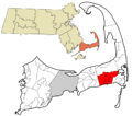
Location in Barnstable County and Massachusetts.
See also
 In Spanish: Harwich (Massachusetts) para niños
