Cape Cod Rail Trail facts for kids
Quick facts for kids Cape Cod Rail Trail |
|
|---|---|

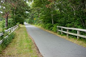
The trail in Harwich, Massachusetts
|
|
| Length | 25.5 miles |
| Location | Barnstable County |
| Established | 1970s |
| Designation | Massachusetts state park |
| Trailheads | Lecount Hollow Road, Wellfleet Station Avenue, South Yarmouth |
| Use | Hiking, cycling, roller blading, horseback riding, cross-country skiing |
| Difficulty | Easy |
| Season | Year-round |
| Hazards | Deer ticks, poison ivy, road crossings |
| Surface | Paved surface |
| Right of way | Former railroad line |
| Maintained by | Department of Conservation and Recreation |
| Website | Cape Cod Rail Trail |
The Cape Cod Rail Trail (CCRT) is a super cool paved path on Cape Cod in Massachusetts. It's about 25.5 miles long. This awesome trail goes through seven towns: Yarmouth, Dennis, Harwich, Brewster, Orleans, Eastham, and Wellfleet.
The trail connects to other paths too. You can link up with the Old Colony Rail Trail which leads to Chatham. There's also a 2-mile path in Yarmouth. Plus, you can find 8 miles of trails inside Nickerson State Park. You can even take short trips on roads to reach amazing beaches like Coast Guard Beach. The Cape Cod Rail Trail is also part of the bigger Claire Saltonstall Bikeway.
Contents
History of the Trail
The Cape Cod Rail Trail used to be a railroad line! It was built a long time ago, starting in the 1860s. The first part, from Yarmouth to Orleans, was built by the Cape Cod Central Railroad. Later, it became part of the Old Colony Railroad. This company finished the line all the way to Provincetown in 1873.
Over the years, different railroad companies owned the line. Eventually, in 1970, the railroad company went out of business. In 1976, the state of Massachusetts bought the land. They decided to turn parts of the old railway into a trail for people to enjoy. The Department of Conservation and Recreation started converting it in the 1970s. Today, the state still owns the land. They let the Department of Conservation and Recreation use it for the trail.
In July 2020, the state planned to make the trail even longer. They want to extend it west from Yarmouth to Barnstable. Since that part of the old rail line is still used by trains, the new trail will follow a different route.
Exploring the Trail
The Cape Cod Rail Trail is a great place for many activities. You can go hiking, cycling, rollerblading, or even cross-country skiing in winter. It's considered an easy trail, so it's good for families and people of all skill levels.
From Yarmouth to Nickerson State Park
The trail starts in Yarmouth at Station Avenue. There's a parking area here, which is handy. From here, the trail goes over Station Avenue on a bridge. It connects to Peter Homer Park and continues as the Yarmouth multi-use trail. This town-owned trail is 2 miles long.
The first 5 miles of the trail go through areas with businesses and homes in Yarmouth and Dennis. You'll even cross over the Bass River on a new trail bridge. The trail often runs next to Great Western Road in this section.
Next, the trail enters Harwich. Here, you'll see houses and farms. The trail then turns north and meets the Old Colony Rail Trail. This meeting point is a special bike rotary! It has maps and benches in the middle where you can rest. North of the rotary, the trail goes through a wooded area. It crosses over Route 6 on a bridge. There's another parking area at Headwaters Drive. The trail crosses Route 124 twice and runs alongside it for a while. You'll pass several ponds and enter Brewster around mile 6.
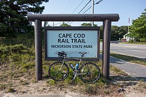
The CCRT crosses Route 137 around mile 8. It then runs south of central Brewster. There's a parking area at Route 137. Just past mile 10, the trail enters Nickerson State Park. It stays in the park for about two-thirds of a mile, connecting to some of the park's own trails. Then, it goes under Route 6A as it leaves the park. You'll find another parking lot near the Route 6A crossing.
From Nickerson State Park to Wellfleet

The trail continues into Orleans between miles 11 and 12. It crosses Namskaket Creek. The trail has a short section where you ride on the road between miles 12 and 13. This is near exit 12 on Route 6. The trail follows Salty Ridge Road to West Road. Then it turns left and heads into downtown Orleans.
The CCRT crosses Main Street just after mile 13. This downtown area has bike shops and places to eat. There's a parking area off Old Colony Way, named after the old railroad. As you leave downtown, the area becomes less busy. The trail crosses over Route 6 again on a bridge just before mile 14.
The trail enters Eastham shortly after this. You'll see a large salt marsh called Boat Meadow Creek on the west side of the trail. Around mile 15, the trail goes into a residential area of Eastham. It crosses Gov. Prence Road. The trail stays pretty straight through most of Eastham. You'll find frequent road crossings at ground level. Locust Road, between miles 16 and 17, is a marked bike route. It leads to the Nauset Bicycle Trail, which takes you to Coast Guard Beach. You can also reach the Salt Pond Visitor Center and other spots in the Cape Cod National Seashore. In North Eastham, near Brackett Road, there are more bike shops, delis, and even a Ben & Jerry's ice cream shop! North of Brackett Road, the trail runs closer to Route 6. Several motels and restaurants are directly connected to the trail.
The CCRT enters Wellfleet near mile 19. On the west side of the trail, you'll see some homes. On the east side, there's a power line area with undeveloped National Seashore land beyond it. North of mile 21, the trail meets Marconi Beach Road. This road leads to Marconi Beach and the historic Marconi Station site. The trail ends near mile 22, at Lecount Hollow Road in Wellfleet. This trailhead has the only parking area north of Orleans. The road also gives you access to several Wellfleet town beaches.
Future Plans for the Trail
People are always working to make the Cape Cod Rail Trail even better! In April 2018, plans were made to extend the trail north. This 2-mile extension will go from Lecount Hollow Road to Route 6 near Wellfleet Center. It will follow the path of the old railroad. As part of this project, the state bought an old campground and fixed it up. The new Wellfleet Hollow Campground opened in May 2019.
There have been talks for many years about extending the bike path all the way north to Provincetown. In 2011, four possible routes were looked at. These included a scenic path through the National Seashore. Another idea was to use back roads west of Route 6. They also considered following the old railroad path, even though some parts are now privately owned. Finally, a route along a power line path from South Wellfleet into Truro and then along Route 6 into Provincetown was discussed.
Images for kids
 | Anna J. Cooper |
 | Mary McLeod Bethune |
 | Lillie Mae Bradford |


