
Provincetown, Massachusetts facts for kids
Quick facts for kids
Provincetown, Massachusetts
|
|||
|---|---|---|---|

Aerial view of Provincetown
|
|||
|
|||
| Nickname(s):
"P-town" or "Ptown"
|
|||
| Motto(s):
"Birthplace of American Liberty"
|
|||

Location in Barnstable County and Massachusetts
|
|||

U.S. Census Map
|
|||

Provincetown, Massachusetts
Location in Massachusetts

Provincetown, Massachusetts
Location in the United States
|
|||
| Country | United States | ||
| State | Massachusetts | ||
| County | Barnstable | ||
| Settled | 1700 | ||
| Incorporated | 1727 | ||
| Government | |||
| • Type | Open town meeting | ||
| Area | |||
| • Total | 17.5 sq mi (45 km2) | ||
| • Land | 9.7 sq mi (25 km2) | ||
| • Water | 7.8 sq mi (20 km2) | ||
| • Federal land | 7.0 sq mi (18 km2) | ||
| • Local land | 2.7 sq mi (7 km2) | ||
| Highest elevation | 100 ft (30 m) | ||
| Lowest elevation | 0 ft (0 m) | ||
| Population | |||
| • Total | 3,664 | ||
| • Density | 377.7/sq mi (145.8/km2) | ||
| • Local density | 1,114.4/sq mi (430.3/km2) | ||
| (excludes Federal Land; better approximates actual density of the year-round population) | |||
| Time zone | UTC-5 (Eastern (EST)) | ||
| • Summer (DST) | UTC-4 (E. Daylight (EDT)) | ||
| ZIP code |
02657
|
||
| Area code(s) | 508 | ||
| FIPS code | 25-55500 | ||
| GNIS feature ID | 0618258 | ||
| Website | http://www.provincetown-ma.gov/ | ||


Provincetown (pronounced PROV-ins-town) is a small town located at the very tip of Cape Cod in Massachusetts, United States. It's often called "P-town" or "Ptown". This coastal town has a year-round population of about 3,664 people. However, in the summer, its population can grow to as many as 60,000 visitors! Provincetown is famous for its beautiful beaches, busy harbor, and a lively community of artists and tourists. It's a popular vacation spot known for being very welcoming to everyone.
Contents
History of Provincetown
Early Days and Native People
Long ago, the area where Provincetown now stands was home to the Nauset tribe. They had a settlement called "Meeshawn." The Nauset people spoke a language similar to their neighbors, the Wampanoag.
.jpg)
In 1602, an explorer named Bartholomew Gosnold arrived. He first called the area "Shoal Hope." But after catching many codfish, he renamed this tip of land "Cape Cod." Much later, the name "Cape Cod" was used for the entire region we know today.
The Pilgrims' Arrival
On November 9, 1620, the Pilgrims sailed on the Mayflower. They first saw Cape Cod while trying to reach Virginia. After two days of struggling against strong winter seas, they found safety in the harbor, now called Provincetown Harbor.
It was here that the Mayflower Compact was written and signed. This important agreement helped them create a self-governing community. A sculpture near the Pilgrim Monument remembers this event.
The Pilgrims later decided to settle across the bay in Plymouth. But Cape Cod was known for its great fishing and its deep, safe harbor. In 1654, the Governor of the Plymouth Colony bought this land from the Nauset Chief. The price included brass kettles, coats, hoes, axes, knives, and a box.
This land was kept for the Plymouth Colony. They leased fishing rights to fishermen, and the money helped pay for schools and other projects. In 1692, the Plymouth and Massachusetts Bay colonies joined to form the Province of Massachusetts Bay. The area was then officially named the "Province Lands."
Becoming a Town
In 1714, the area was called the "Precinct of Cape Cod" and was part of Truro. On June 14, 1727, after being a harbor for over a century, the Precinct of Cape Cod became a town. The people wanted to call it "Herringtown," but the government chose "Provincetown" instead.
At first, people in Provincetown could use land but not own it. The land was meant for fishing. But in 1893, the town's rules changed, allowing people to own their properties.
Growth and Change
Provincetown grew quickly after the American Revolution. It became a major center for fishing and whaling. Many Portuguese sailors, especially from the Azores, came to live here after working on US ships.


By the 1890s, Provincetown was thriving. Writers and artists began to live there, and summer tourism started to grow. After a big storm in 1898 damaged the fishing industry, artists moved into many empty buildings. By the early 1900s, Provincetown was known worldwide for its art and literature.
The Provincetown Players was an important experimental theater group formed during this time. In 1898, Charles Webster Hawthorne opened the Cape Cod School of Art in Provincetown. It was one of the first outdoor schools for painting people.
In the mid-1960s, more people moved to Provincetown. The town's quiet, natural feel attracted many. Property was affordable, especially in winter. Many who came decided to stay and raise families. Commercial Street, the main business area, gained many cafes and shops.
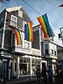
By the 1970s, Provincetown became a very welcoming place for diverse communities, especially during the summer. This welcoming spirit had been present since the early 1900s with the growth of the artists' colony and experimental theater. In 1978, the Provincetown Business Guild was created to promote tourism. Today, Provincetown is known as a very open and accepting summer destination.
Since the 1990s, property prices have increased. However, the town's economy has continued to grow. Provincetown now hosts many festivals and events throughout the year. Popular summer events include the Portuguese Festival, Bear Week, and Carnival Week. In 2017, a memorial was built to honor those who lost their lives to AIDS.
How Transportation Shaped Provincetown


For most of its history, Provincetown's life centered around its waterfront. The harbor offered a deep, safe place for boats, protected from wind and waves. The town was also very isolated, located at the hard-to-reach tip of a long, narrow peninsula.
The East Harbor, which was a very protected place for boats, had a wide opening to Provincetown Harbor. This opening blocked land access to Provincetown. Until the late 1800s, there was no proper road into town. The only land path was a thin stretch of beach that storms sometimes washed away. This made Provincetown feel much like an island. Its residents relied almost entirely on the harbor for travel, communication, and trade.
Things changed in 1868 when the East Harbor was diked (a wall was built) to allow for railroad tracks. The railroad arrived in 1873, bringing much excitement. The old wooden bridge and sand road were replaced by a proper road in 1877. The railroad ended at Railroad Wharf, now called MacMillan Pier. This made it easy for fishermen to ship their catch to cities by train.
Even roads within the town were built slowly. Early on, people mostly used paths from their houses to their boats. The main "road" was the hard-packed beach itself, where all business and social life happened. In 1835, a footpath behind the houses became "Front Street," now known as Commercial Street. "Back Street," parallel to Front Street, is now Bradford Street.
Geography and Climate
Where is Provincetown?
Provincetown is located at the very tip of Cape Cod. It covers about 17.5 square miles (45 square kilometers). About 9.7 square miles (25 square kilometers) is land, and 7.8 square miles (20 square kilometers) is water. The town is surrounded by water on three sides, with 21.3 miles (34.3 kilometers) of coastline. Its only land neighbor is the town of Truro to the east.
Provincetown is about 45 miles (72 km) north of Barnstable and Hyannis, Massachusetts. It's about 62 miles (100 km) by road to the Sagamore Bridge, which connects Cape Cod to the mainland. Boston is about 45 miles (72 km) away by air or sea, and 115 miles (185 km) by road.
About 73% of the town's land is owned by the National Park Service. This land is part of the Cape Cod National Seashore. This leaves about 2.7 square miles (7.0 square kilometers) of land under the town's control. To the north are the "Province Lands," an area of dunes and small ponds. Three lighthouses mark important points along the coast: Race Point, Wood End, and Long Point.
Provincetown's Weather
Provincetown has a climate with warm summers. The average snowfall from November to April is about 30 inches (76 cm). February usually has the most snow.
| Climate data for Provincetown, Barnstable County, Massachusetts (1981–2010 averages). | |||||||||||||
|---|---|---|---|---|---|---|---|---|---|---|---|---|---|
| Month | Jan | Feb | Mar | Apr | May | Jun | Jul | Aug | Sep | Oct | Nov | Dec | Year |
| Record high °F (°C) | 62 (17) |
69 (21) |
79 (26) |
85 (29) |
92 (33) |
98 (37) |
104 (40) |
98 (37) |
93 (34) |
82 (28) |
77 (25) |
66 (19) |
104 (40) |
| Mean maximum °F (°C) | 51 (11) |
50 (10) |
58 (14) |
68 (20) |
79 (26) |
86 (30) |
91 (33) |
89 (32) |
83 (28) |
74 (23) |
64 (18) |
56 (13) |
91 (33) |
| Mean daily maximum °F (°C) | 37.6 (3.1) |
38.6 (3.7) |
43.9 (6.6) |
52.2 (11.2) |
63.0 (17.2) |
72.9 (22.7) |
79.0 (26.1) |
78.2 (25.7) |
71.4 (21.9) |
61.3 (16.3) |
52.0 (11.1) |
43.2 (6.2) |
57.4 (14.1) |
| Daily mean °F (°C) | 31.5 (−0.3) |
32.3 (0.2) |
37.4 (3.0) |
45.6 (7.6) |
55.2 (12.9) |
65.1 (18.4) |
71.3 (21.8) |
70.6 (21.4) |
64.1 (17.8) |
54.3 (12.4) |
45.7 (7.6) |
36.9 (2.7) |
50.7 (10.4) |
| Mean daily minimum °F (°C) | 25.3 (−3.7) |
25.9 (−3.4) |
30.9 (−0.6) |
38.9 (3.8) |
47.5 (8.6) |
57.2 (14.0) |
63.5 (17.5) |
63.1 (17.3) |
56.9 (13.8) |
47.2 (8.4) |
39.3 (4.1) |
30.6 (−0.8) |
43.9 (6.6) |
| Mean minimum °F (°C) | 6 (−14) |
9 (−13) |
16 (−9) |
27 (−3) |
36 (2) |
44 (7) |
52 (11) |
50 (10) |
42 (6) |
32 (0) |
24 (−4) |
13 (−11) |
5 (−15) |
| Record low °F (°C) | −6 (−21) |
−8 (−22) |
6 (−14) |
16 (−9) |
25 (−4) |
35 (2) |
38 (3) |
34 (1) |
29 (−2) |
19 (−7) |
14 (−10) |
−6 (−21) |
−8 (−22) |
| Average precipitation inches (mm) | 3.70 (94) |
3.17 (81) |
4.63 (118) |
4.07 (103) |
3.28 (83) |
3.46 (88) |
2.96 (75) |
3.24 (82) |
3.55 (90) |
3.81 (97) |
4.26 (108) |
3.83 (97) |
43.96 (1,117) |
| Average snowfall inches (cm) | 6.9 (18) |
7.4 (19) |
4.5 (11) |
0.7 (1.8) |
0.0 (0.0) |
0.0 (0.0) |
0.0 (0.0) |
0.0 (0.0) |
0.0 (0.0) |
0.0 (0.0) |
0.2 (0.51) |
4.1 (10) |
23.8 (60.31) |
| Average relative humidity (%) | 68.1 | 66.2 | 66.6 | 69.2 | 70.5 | 72.9 | 74.8 | 73.7 | 74.9 | 69.9 | 67.1 | 66.5 | 70.1 |
| Source: PRISM Climate Group | |||||||||||||
People of Provincetown
| Historical population | ||
|---|---|---|
| Year | Pop. | ±% |
| 1850 | 3,157 | — |
| 1860 | 3,206 | +1.6% |
| 1870 | 3,865 | +20.6% |
| 1880 | 4,346 | +12.4% |
| 1890 | 4,642 | +6.8% |
| 1900 | 4,247 | −8.5% |
| 1910 | 4,369 | +2.9% |
| 1920 | 4,246 | −2.8% |
| 1930 | 3,808 | −10.3% |
| 1940 | 3,668 | −3.7% |
| 1950 | 3,795 | +3.5% |
| 1960 | 3,389 | −10.7% |
| 1970 | 2,911 | −14.1% |
| 1980 | 3,536 | +21.5% |
| 1990 | 3,561 | +0.7% |
| 2000 | 3,431 | −3.7% |
| 2010 | 2,942 | −14.3% |
| 2020 | 3,664 | +24.5% |
| 2023* | 3,709 | +1.2% |
| * = population estimate. Source: United States Census records and Population Estimates Program data. |
||
Population Facts
In 2010, the U.S. Census counted 2,942 people living in Provincetown. The town is mostly White (91.5%), with smaller percentages of African American, Native American, Asian, and other races. About 4.8% of the population was Hispanic or Latino.
Many people in Provincetown have Irish, English, Portuguese, Italian, or German backgrounds. The average household size was 1.64 people. The median age in 2010 was 52.3 years old.
Provincetown is a popular resort town. This means its population changes a lot between seasons. The year-round population is small, but during the summer, it can jump to 19,000 to 60,000 visitors. Many homes are used only for vacations, which is why there are more houses than full-time residents.
Arts and Culture in Provincetown

Provincetown has a rich history in arts and culture.
- Provincetown Playhouse: In 1940, Catharine Sargent Huntington and others started the Provincetown Playhouse on the Wharf. It produced plays, including many by famous writer Eugene O'Neill.
- Sun Gallery: From 1955 to 1959, the Sun Gallery was a place for young, new artists to show their work during the summer.
- Fine Arts Work Center: Since 1968, this center has helped new visual artists and writers grow. It aims to bring back the lively art community of Provincetown year-round.
- Provincetown Art Association and Museum (PAAM): PAAM is a well-known art museum that celebrated its 100th birthday in 2014. It holds about 35 art shows each year. PAAM also offers art workshops for kids and adults. Its collection has 3,000 art pieces.
- MacMillan Pier: In 2003, Provincetown received a loan to help rebuild its MacMillan Pier. This pier is important for the town's fishing boats. It also welcomes tourists and high-speed ferries.
- Atlantic House: The Atlantic House is considered one of the oldest welcoming bars in the US.
- Women's Week: Since 1984, Provincetown has hosted Women's Week in mid-October. It is a long-running cultural event in the Northeast.
- Fantasia Fair: Since 1975, Provincetown has hosted Fantasia Fair. This is the world's first and longest-running conference about gender diversity.
- Provincetown International Film Festival: This festival celebrates the best independent and unique films. Famous actors and directors like Patricia Clarkson and David Cronenberg have been honored here. Filmmaker John Waters, who lives in Provincetown in the summer, is a big part of the festival.
- Provincetown Theater Company: In 2011, this theater company was the first in New England to perform a live play based on horror writer H.P. Lovecraft's work.
Community and Education
Community Center
The Veterans Memorial Community Center is the town's community hub. It was once an elementary school. In 2014, the town thought about adding affordable housing to its second floor.
Schools in Provincetown

Provincetown Schools teaches children from Pre-K through 8th grade. The main building is an International Baccalaureate World School for grades 1-8. The Early Learning Center (for ages 3-5 and kindergarten) is in the Veterans Memorial Community Center.
In 2010, the town decided to close Provincetown High School's program. Starting in the 2013-2014 school year, high school students from Provincetown began attending Nauset Regional High School in North Eastham. Some students also go to Cape Cod Regional Technical High School in Harwich.
There are no private schools in Provincetown. Before it closed, Provincetown High School served students from 7th to 12th grades. In 2012, it was one of the smallest high schools in the country, with only 32 students in grades 10-12.
Students from Provincetown and Truro can apply for private scholarships. These include the John Anderson Francis Family Scholarship Fund and the Captain Joseph F. Oliver Scholarship Fund.
Getting Around Provincetown


Roads and Ferries
U.S. Route 6 ends in Provincetown. Route 6A also runs through the town, mostly along Bradford Street.
Provincetown has seasonal ferries to Boston and Plymouth. They all dock at MacMillan Pier. This pier is very busy. It handles many ferry trips, whale watching boats, and the town's fishing fleet. It also welcomes cruise ships.
No Train Service
Provincetown no longer has train service. The Provincetown Train Station opened in 1873 but closed in 1938. Part of the old train line is now a pedestrian path called the "Old Colony Nature Pathway."
Buses and Bikes
The Cape Cod Regional Transit Authority offers bus services. Buses connect MacMillan Pier to Harwich and Truro. Other bus lines provide service to Hyannis, Boston, New York, and Providence.
Provincetown is at one end of the "Bike Route 1" from Boston, called the Claire Saltonstall Bikeway. The town has won awards for being bicycle-friendly. Provincetown has the highest rate of year-round bicycle commuters in Massachusetts, with 14% of people biking to work.
Airport
The Provincetown Municipal Airport is located near Race Point. It's a small airport mostly used for private planes. However, it also has regular flights to Boston and White Plains, New York, through Cape Air.
Notable People from Provincetown
Many famous people have lived or spent time in Provincetown.
Actors and Entertainers
- Murray Bartlett (born 1971), actor
- Judy Gold (born 1962), stand-up comedian
- Channing Wilroy (born 1940), actor
Chefs and Explorers
- Anthony Bourdain (1956–2018), chef, author, television host
- Barry Clifford (born 1945), underwater explorer
- Donald B. MacMillan (1874–1970), arctic explorer
Writers and Journalists
- Louise Bryant (1885–1936), journalist, author
- Michael Cunningham (born 1952), Pulitzer Prize-winning author
- Mark Doty (born 1953), poet, author
- Susan Glaspell (1876–1948), Pulitzer Prize-winning playwright
- Harry Kemp (1883–1960), "poet of the dunes"
- Stanley Kunitz (1905–2006), former United States Poet Laureate
- Norman Mailer (1923–2007), Pulitzer Prize-winning author
- Mary Oliver (1935–2019), Pulitzer Prize-winning poet
- Eugene O'Neill (1888–1953), Pulitzer Prize and Nobel Prize-winning author
- John Waters (born 1946), filmmaker and author
- Kurt Vonnegut (1922–2007), Hugo Award-winning author
- Tennessee Williams (1911–1983), Pulitzer Prize-winning playwright
Visual Artists
- Edwin Dickinson (1891–1978), painter
- Helen Frankenthaler (1928–2011), abstract expressionist painter
- Charles Webster Hawthorne (1872–1930), painter, founder of the Cape Cod School of Art
- Hans Hofmann (1880–1966), painter and teacher
- Edward Hopper (1882–1967), American realist painter
- Franz Kline (1910–1962), abstract expressionist painter
- Willem de Kooning (1904–1997), abstract expressionist artist
- Robert Motherwell (1915–1991), abstract expressionist painter
- Mark Rothko (1903–1970), abstract expressionist artist
Images for kids
-
Commercial Street in Provincetown
See also
 In Spanish: Provincetown para niños
