
Barnstable, Massachusetts facts for kids
Quick facts for kids
Barnstable
|
|||
|---|---|---|---|
|
Town
|
|||

|
|||
|
|||

Location in Barnstable County and the state of Massachusetts.
|
|||

Barnstable
Location in Massachusetts

Barnstable
Location in the United States
|
|||
| Country | United States | ||
| State | Massachusetts | ||
| County | Barnstable County | ||
| Settled | June 4, 1638 | ||
| Incorporated (town) | September 3, 1639 | ||
| Incorporated (city) | April 11, 1989 | ||
| Named for | Barnstaple, England | ||
| Government | |||
| • Type | Council-manager city | ||
| Area | |||
| • Town | 76.47 sq mi (198.05 km2) | ||
| • Land | 59.93 sq mi (155.22 km2) | ||
| • Water | 16.54 sq mi (42.83 km2) | ||
| Elevation | 37 ft (11 m) | ||
| Population
(2020)
|
|||
| • Town | 48,916 | ||
| • Density | 816.23/sq mi (315.15/km2) | ||
| • Urban | 303,269 (US: 133rd) | ||
| • Urban density | 888.6/sq mi (343.1/km2) | ||
| • Metro | 228,996 (US: 201st) | ||
| Time zone | UTC−5 (Eastern) | ||
| • Summer (DST) | UTC−4 (Eastern) | ||
| ZIP code |
02601
|
||
| Area code(s) | 508 / 774 | ||
| FIPS code | 25-03690 | ||


Barnstable is a town in the U.S. state of Massachusetts. It is the main town of Barnstable County. Barnstable is the largest community on Cape Cod in both land area and population.
Even though it has a city-like government, Barnstable still uses "the town of" in its official name. In 2020, about 48,916 people lived here. The town has several smaller areas called villages. The biggest village, Hyannis, is the main business center for the county. It is also home to Barnstable Municipal Airport, which is a key airport for flights to Cape Cod and the islands of Martha's Vineyard and Nantucket. Barnstable won the All-America City Award in 2007, which recognizes communities for their efforts to solve local problems.
Contents
Discovering Barnstable's Past


Barnstable got its name from the English town of Barnstaple in Devon, England. The first European to explore this area was Bartholomew Gosnold in 1602.
Early Settlement and Growth
Barnstable was settled in 1638. It was one of the first towns in the Plymouth Colony. It officially became a town on September 4, 1639. This was the same day as the nearby towns of Sandwich and Yarmouth.
The first settlers were farmers. They were led by Reverend Joseph Hull. A special marker was placed in 1939 to show where his home was. The rock where he used to preach is still there today.
Industries and Changes Over Time
Soon after the town was founded, farming, fishing, and making salt became its main jobs. By the late 1800s, many ships were docked in Barnstable. However, the importance of sailing ships decreased as steamships and railroads became popular. The railroad arrived in 1854.
Barnstable as a Tourist Hotspot
By the late 1800s, Barnstable started to become a famous place for tourists. Many important people from Boston spent their summers here. Even presidents like Ulysses S. Grant and Grover Cleveland visited.
The most famous family to spend summers in Barnstable was the Kennedy family. They still have their home, called the Kennedy Compound, in Hyannis Port. This was the summer home of President John F. Kennedy. It was also the home of Senator Ted Kennedy until he passed away.
Today, many tourists visit Barnstable during the summer. Hyannis has many shops and museums, like the John F. Kennedy Museum. Historic places like the Ancient Burying Ground and Gideon Hawley House show the town's long history. The town's many beaches are also very popular.
Exploring Barnstable's Geography

Barnstable is located about halfway along the "arm" shape of Cape Cod. It covers about 76.47 square miles (197.7 square kilometers). About 21.66% of this area is water.
Neighboring Areas and Waterways
To the north, Barnstable is next to Cape Cod Bay. To the south, it borders Nantucket Sound. On the west, it is next to Sandwich and Mashpee. To the east, it borders Yarmouth. Barnstable is about 70 miles (113 kilometers) southeast of Boston.
Villages Within Barnstable
The Town of Barnstable includes several villages. These are not separate legal towns. Here are some of the commonly known villages:
- The village of Barnstable (02630), including Cummaquid (02637)
- Centerville (02632)
- Cotuit (02635)
- Hyannis (02601), including Hyannis Port (02647) and West Hyannisport (02672)
- Marstons Mills (02648)
- Osterville (02655)
- West Barnstable (02668)
North of Barnstable, you can find the sand dunes of Sandy Neck. This area is along Barnstable Harbor and has the Sandy Neck Light. The middle part of the town has many pine and oak trees around Wequaquet Lake. Most people live in the southern part of town, often near the beaches of Centerville and Hyannis Harbors. Hyannis is the largest village in Barnstable.
Understanding Barnstable's Climate
Barnstable has a humid continental climate. This means it has cold winters and warm summers. The average snowfall from November to April is about 30 inches (76 cm). February is usually the snowiest month. This is also when big winter storms called nor'easters are most common.
| Climate data for Barnstable, Barnstable County, Massachusetts (1981 – 2010 averages) | |||||||||||||
|---|---|---|---|---|---|---|---|---|---|---|---|---|---|
| Month | Jan | Feb | Mar | Apr | May | Jun | Jul | Aug | Sep | Oct | Nov | Dec | Year |
| Mean daily maximum °F (°C) | 37.8 (3.2) |
39.4 (4.1) |
44.7 (7.1) |
53.2 (11.8) |
62.8 (17.1) |
72.2 (22.3) |
78.2 (25.7) |
77.4 (25.2) |
71.1 (21.7) |
61.3 (16.3) |
52.9 (11.6) |
43.3 (6.3) |
57.9 (14.4) |
| Daily mean °F (°C) | 30.2 (−1.0) |
31.8 (−0.1) |
37.3 (2.9) |
45.6 (7.6) |
55.0 (12.8) |
64.7 (18.2) |
70.8 (21.6) |
70.2 (21.2) |
63.4 (17.4) |
53.5 (11.9) |
45.3 (7.4) |
35.8 (2.1) |
50.4 (10.2) |
| Mean daily minimum °F (°C) | 22.6 (−5.2) |
24.2 (−4.3) |
29.8 (−1.2) |
38.1 (3.4) |
47.2 (8.4) |
57.2 (14.0) |
63.5 (17.5) |
63.0 (17.2) |
55.8 (13.2) |
45.7 (7.6) |
37.7 (3.2) |
28.4 (−2.0) |
42.9 (6.1) |
| Average precipitation inches (mm) | 3.72 (94) |
3.26 (83) |
4.60 (117) |
4.24 (108) |
3.31 (84) |
3.53 (90) |
3.19 (81) |
3.49 (89) |
3.67 (93) |
4.01 (102) |
4.11 (104) |
4.21 (107) |
45.34 (1,152) |
| Average relative humidity (%) | 69.1 | 68.2 | 66.9 | 69.2 | 72.2 | 74.7 | 76.9 | 77.1 | 77.1 | 73.7 | 70.6 | 70.1 | 72.2 |
| Average dew point °F (°C) | 21.3 (−5.9) |
22.5 (−5.3) |
27.3 (−2.6) |
36.1 (2.3) |
46.2 (7.9) |
56.5 (13.6) |
63.2 (17.3) |
62.7 (17.1) |
56.1 (13.4) |
45.3 (7.4) |
36.3 (2.4) |
27.0 (−2.8) |
41.8 (5.4) |
| Source: PRISM Climate Group | |||||||||||||
Understanding Barnstable's Population
| Historical population | ||
|---|---|---|
| Year | Pop. | ±% |
| 1840 | 4,301 | — |
| 1850 | 4,901 | +14.0% |
| 1860 | 5,129 | +4.7% |
| 1870 | 4,793 | −6.6% |
| 1880 | 4,242 | −11.5% |
| 1890 | 4,023 | −5.2% |
| 1900 | 4,364 | +8.5% |
| 1910 | 4,676 | +7.1% |
| 1920 | 4,836 | +3.4% |
| 1930 | 7,271 | +50.4% |
| 1940 | 8,333 | +14.6% |
| 1950 | 10,480 | +25.8% |
| 1960 | 13,465 | +28.5% |
| 1970 | 19,842 | +47.4% |
| 1980 | 30,898 | +55.7% |
| 1990 | 40,949 | +32.5% |
| 2000 | 47,821 | +16.8% |
| 2010 | 45,193 | −5.5% |
| 2020 | 48,916 | +8.2% |
| 2023 | 49,709 | +1.6% |
| source: Source: |
||
In 2000, Barnstable had 47,821 people living there. There were 19,626 households, which are groups of people living together. About 13,012 of these were families. The population density was about 796.5 people per square mile.
Diversity in Barnstable
Most of the people in Barnstable were White (91.85%). Other groups included Black or African American (2.74%), Native American (0.59%), and Asian (0.81%). About 1.70% of the population was Hispanic or Latino.
Many people in Barnstable have Irish (24.2%), English (13.3%), or Italian (9.3%) backgrounds. Most people (92.1%) spoke English at home. Other languages spoken included Portuguese (3.4%), Spanish (1.6%), and French (1.0%).
Age and Households
About 22.0% of the population was under 18 years old. About 20.1% were 65 years or older. The average age in Barnstable was 42 years.
About 26.9% of households had children under 18. Most households (52.4%) were married couples living together. About 10.7% were female householders without a husband present.
Education in Barnstable
Barnstable has the largest public school system on Cape Cod. Over 5,000 students attend its schools. In 2010, the school system made some big changes because of money limits.
Public Schools for All Ages
The Enoch Cobb Early Learning Center is for pre-school students. There are five elementary schools for grades K-3:
- Centerville Elementary School
- Barnstable Community Horace Mann Public Charter School (formerly Hyannis East Elementary School)
- West Villages Elementary School (formerly Marstons Mills East Elementary School)
- Hyannis West Elementary School
- Barnstable-West Barnstable Elementary School
The Barnstable United Elementary School teaches students in fourth and fifth grade. The Barnstable Intermediate School is for students in sixth and seventh grade. Barnstable High School serves students from eighth to twelfth grade.
Barnstable High School's sports teams are called the Red Hawks. Their colors are red and white. They are very successful because they have many students to choose from. Their main rivals are Dennis/Yarmouth and Falmouth. Barnstable and Falmouth have played football on Thanksgiving Day almost every year since 1895. This is one of the longest-running high school football rivalries ever!
Private and Specialized Schools
Barnstable also has several private schools. There are Christian schools like Bayberry Christian Academy, Faith Christian School, and Trinity Christian Academy. There are also two Catholic schools: Saint Francis Xavier Prep and Pope John Paul II High School.
Other private schools include the Academy of Early Learning and Veritas Academy. The Cape Cod Academy is a private school for students from kindergarten through 12th grade. For students with special needs, there are Southeast Alternative and Beacon Point schools. The Sturgis Charter School is for high school students. High school students can also attend Cape Cod Regional Technical High School in Harwich for free.
Higher Education Opportunities
Barnstable is home to Cape Cod Community College. This is a two-year college connected with Suffolk University in Boston.
Getting Around Barnstable: Transportation
Barnstable has major roads like U.S. Route 6 and Massachusetts Route 28. Route 6 is a four-lane highway that goes through the town. Other routes like 6A, 132, and 149 are also in town.
Train and Bus Services
Since 2013, the CapeFlyer train runs on weekends from Memorial Day to Columbus Day. For year-round train service to Boston, you can use the MBTA's commuter rail from stations like Kingston/Route 3. The closest long-distance train stations (Amtrak) are in Boston and Providence. Freight trains are operated by the Massachusetts Coastal Railroad.
The Cape Cod Central Railroad offers fun tourist train rides. These run from Hyannis to Sandwich and Sagamore. Some trains stop at the West Barnstable station.
Air and Ferry Travel
Barnstable has two airports. Cape Cod Airfield is smaller and mostly for private planes. Barnstable Municipal Airport is for regional flights, especially to the islands. The airline Cape Air has its main office in Barnstable. For bigger national and international flights, you can go to Logan International Airport in Boston.
Hyannis is also where the main ferry boats leave for Nantucket and Martha's Vineyard.
Famous People from Barnstable
- Joe Cronin, a famous baseball player and Hall of Famer
- Gary DiSarcina, a baseball player and coach
- Isaac Dunbar, a singer-songwriter
- Andy Hallett, an actor and singer
- Tom Hamilton, bassist for the rock band Aerosmith
- John Havlicek, a basketball player for the Boston Celtics
- Amy Jo Johnson, the original Pink Power Ranger
- Herbert Kalmus, who helped start Technicolor Corporation
- Edward M. Kennedy, a U.S. senator
- John F. Kennedy, the 35th President of the United States
- Joseph P. Kennedy Sr., a U.S. Ambassador
- Joseph P. Kennedy II, a U.S. Representative
- Patrick J. Kennedy, a U.S. Congressman
- Robert F. Kennedy, a U.S. Attorney General and senator
- Rose Fitzgerald Kennedy, the mother of the Kennedy family
- Jack Kerouac, a famous writer and poet
- Paul G. Kirk, a U.S. senator
- Dan LaCouture, an NHL hockey player
- Siobhan Magnus, a singer from American Idol
- Neal McDonough, a film and TV actor
- Eric Nickulas, an NHL hockey player for the Boston Bruins
- James Otis, an American patriot during the Revolution
- Paul Pena, a blues singer and guitarist
- John Percival, a captain of the USS Constitution
- Robert Richardson, an Academy Award-winning cinematographer
- Marnie Schulenburg, an actor
- Lemuel Shaw, a Chief Justice of Massachusetts
- Casey Sherman, a bestselling author
- Eunice Kennedy Shriver, who started the Special Olympics
- Robert Sargent Shriver Jr., who started the Peace Corps
- Paul Stewart, a professional hockey player and referee
- Kathleen Kennedy Townsend, a lieutenant governor
- Kurt Vonnegut, a famous author
- Mercy Otis Warren, an author and American patriot
- Max Willman, a hockey player for the Philadelphia Flyers
Images for kids
-
Seal of Barnstable, Massachusetts
-
Flag of Barnstable, Massachusetts
-
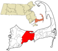
Location in Barnstable County and Massachusetts
See also
 In Spanish: Barnstable (Massachusetts) para niños
