
Mashpee, Massachusetts facts for kids
Quick facts for kids
Mashpee
|
|||
|---|---|---|---|

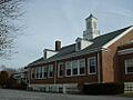
Mashpee Town Hall
|
|||
|
|||

Location in Barnstable County and the state of Massachusetts.
|
|||
| Country | United States | ||
| State | Massachusetts | ||
| County | Barnstable | ||
| Settled | 1660 | ||
| Incorporated | May 28, 1870 | ||
| Government | |||
| • Type | Open town meeting | ||
| Area | |||
| • Total | 27.2 sq mi (70.5 km2) | ||
| • Land | 23.4 sq mi (60.6 km2) | ||
| • Water | 3.8 sq mi (9.9 km2) | ||
| Elevation | 55 ft (17 m) | ||
| Population
(2020)
|
|||
| • Total | 15,060 | ||
| • Density | 644/sq mi (248.5/km2) | ||
| Time zone | UTC−5 (Eastern) | ||
| • Summer (DST) | UTC−4 (Eastern) | ||
| ZIP Code |
02649
|
||
| Area code(s) | 508/774 | ||
| FIPS code | 25-39100 | ||
| GNIS feature ID | 0618256 | ||


Mashpee (/ˈmæʃpi/ Wampanoag: Mâseepee) is a town located in Barnstable County, Massachusetts, on Cape Cod. In 2020, about 15,060 people lived there. Mashpee is important because it is home to the main offices and many members of the Mashpee Wampanoag Tribe. This tribe is one of two Wampanoag groups officially recognized by the United States government.
Contents
Exploring Mashpee's Past
Mashpee has a long and interesting history, especially concerning its native people.
Early Days: Native Americans on Cape Cod

For over 10,000 years, indigenous peoples lived on Cape Cod. When English colonists arrived in the 1600s, they met the Wampanoag people. The Wampanoag spoke an Algonquian language and controlled much of the coastal area. These two cultures, English and Wampanoag, would interact and change each other for many years.
The 1600s: English Settlers and Wampanoag Land
English colonists started settling in the Mashpee area in 1658. They were helped by a missionary named Richard Bourne from the nearby town of Sandwich. In 1660, the colonists set aside about 50 square miles (130 km2) of land for Christian Wampanoag people. By 1665, the Wampanoag began to govern themselves using a court system similar to the English one, though they had their own customs for a long time.

After a conflict known as King Philip's War (1675–1676), many Wampanoag people from the mainland were moved to areas like Mashpee in Barnstable County. Mashpee became the largest Indian reservation in Massachusetts. The name "Mashpee" comes from a native word, mass-nippe, which means "great water" or "land near great cove." This likely refers to Wakeby Pond.
The 1700s: Challenges for the Wampanoag
In 1763, the British Crown declared Mashpee a "plantation." This meant the Wampanoag's self-governed area became part of the colonial district. Even though the Wampanoag could elect their own officials, they were still under colonial rule. Their population decreased, and English settlers began to take over their lands.
After the American Revolutionary War, in 1788, the town took away Mashpee's self-government. European-American officials thought it wasn't working well. A Pequot preacher named William Apess helped the Mashpee Wampanoag protest this decision peacefully.
The 1800s: Land Changes and Town Incorporation
In 1834, the state gave the Wampanoag some self-government back, but they were not fully independent. To encourage them to farm like European-Americans, the state divided some of their shared land in 1842. About 2,000 acres (8.1 km2) of their 13,000-acre (53 km2) property were given out in 60-acre (240,000 m2) plots to families.
Laws were passed to stop European Americans from taking Wampanoag land, but these laws were not always enforced. Settlers also stole wood from the reservation. Mashpee was a large area with lots of wood, fish, and game, which other settlers wanted. The Mashpee people faced more conflicts with their neighbors than other Native American settlements.
In 1870, Mashpee officially became a town. This meant the Wampanoag eventually lost control of their land and full self-government. However, many of their descendants still live in the area and keep their community culture alive.
The 1900s and 2000s: Reorganization and Recognition
In the early 1970s, the Mashpee Wampanoag people reorganized. They tried to get their lands back through a legal claim. While they didn't win that case, they continued to grow as an organized community. In 2007, they finally received official recognition as a tribe from the United States government.
Today, Mashpee is known for both tourism and its unique Wampanoag culture. Many visitors come in the summer, creating jobs in services and businesses. The Mashpee Wampanoag Tribe has its headquarters here. In 2015, the government considered making 170 acres (0.69 km2) in Mashpee a reservation for the Wampanoag. However, this request was turned down in 2018.
The Wampanoag hold an annual pow-wow, which is a special gathering where they share both modern and traditional activities and crafts.
Mashpee's Location and Environment
Mashpee is located on the western part of Cape Cod. It covers about 70.5 square kilometers (27.2 sq mi), with 60.6 square kilometers (23.4 sq mi) being land and 9.9 square kilometers (3.8 sq mi) being water.
Neighboring Towns and Natural Features
Mashpee is bordered by Sandwich to the north, Barnstable to the east, Nantucket Sound to the south, and Falmouth to the west. It's about 65 miles (105 km) south-southeast of Boston.
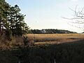
Like other towns on Cape Cod, Mashpee has sandy soil, small ponds, and inlets. It's surrounded by pine and oak trees. The town's coastline includes Waquoit Bay to the west and Popponesset Bay to the east. There are also several rivers, brooks, and small ponds. You can find South Cape Beach State Park and the Lowell Holly Reservation here.
Mashpee also touches a small part of Otis Air National Guard Base, Joint Base Cape Cod, and Camp Edwards in its northwest section.
Weather and Climate
Mashpee has a humid continental climate. This means it has warm summers and gets rain all year round. Winters are cold, with average snowfall around 30 inches (76 cm). February is usually the snowiest month.
| Climate data for Mashpee, Barnstable County, Massachusetts (1981–2010 averages) | |||||||||||||
|---|---|---|---|---|---|---|---|---|---|---|---|---|---|
| Month | Jan | Feb | Mar | Apr | May | Jun | Jul | Aug | Sep | Oct | Nov | Dec | Year |
| Mean daily maximum °F (°C) | 37.8 (3.2) |
39.6 (4.2) |
45.1 (7.3) |
54.0 (12.2) |
63.4 (17.4) |
72.9 (22.7) |
78.7 (25.9) |
78.0 (25.6) |
71.8 (22.1) |
61.9 (16.6) |
53.1 (11.7) |
43.4 (6.3) |
58.4 (14.7) |
| Daily mean °F (°C) | 30.1 (−1.1) |
31.8 (−0.1) |
37.5 (3.1) |
46.2 (7.9) |
55.5 (13.1) |
65.2 (18.4) |
71.3 (21.8) |
70.7 (21.5) |
64.0 (17.8) |
53.9 (12.2) |
45.4 (7.4) |
35.8 (2.1) |
50.7 (10.4) |
| Mean daily minimum °F (°C) | 22.4 (−5.3) |
24.1 (−4.4) |
29.9 (−1.2) |
38.4 (3.6) |
47.6 (8.7) |
57.6 (14.2) |
63.9 (17.7) |
63.3 (17.4) |
56.2 (13.4) |
45.9 (7.7) |
37.7 (3.2) |
28.2 (−2.1) |
43.0 (6.1) |
| Average precipitation inches (mm) | 4.03 (102) |
3.38 (86) |
5.17 (131) |
4.46 (113) |
3.44 (87) |
3.95 (100) |
3.41 (87) |
3.82 (97) |
3.88 (99) |
4.23 (107) |
4.40 (112) |
4.58 (116) |
48.75 (1,238) |
| Average relative humidity (%) | 68.5 | 68.5 | 66.9 | 66.6 | 70.3 | 73.5 | 74.8 | 75.0 | 75.0 | 72.3 | 69.5 | 69.8 | 70.9 |
| Average dew point °F (°C) | 21.0 (−6.1) |
22.6 (−5.2) |
27.5 (−2.5) |
35.7 (2.1) |
46.0 (7.8) |
56.5 (13.6) |
62.9 (17.2) |
62.4 (16.9) |
55.9 (13.3) |
45.2 (7.3) |
36.0 (2.2) |
26.9 (−2.8) |
41.6 (5.3) |
| Source: PRISM Climate Group | |||||||||||||
Plants and Animals of Mashpee
Mashpee's natural environment mostly features Northeastern Oak and Pine trees. It also has areas of Southern Mixed Forest.
Mashpee Neighborhoods

Some of the areas within Mashpee include:
Getting Around Mashpee
Major roads in Mashpee include Massachusetts Route 28, Massachusetts Route 130, and Massachusetts Route 151. Route 28 is one of the main roads that goes east and west across Cape Cod.
Mashpee is the only town on Cape Cod that never had a public railroad built to it. However, Joint Base Cape Cod has a railroad track that extends into the town.
For air travel, the closest airports are Cape Cod Airfield (for small planes) and Barnstable Municipal Airport (the largest airport on the Cape). These are both in the neighboring town of Barnstable. For bigger flights, you can go to Logan International Airport in Boston or T. F. Green Airport in Warwick, Rhode Island.
The Cape Cod Regional Transit Authority provides bus service in Mashpee. The Sealine bus route stops at South Cape Village and Mashpee Commons.
Historic Places and Nature Preserves

Mashpee has several important historic and natural sites:
- Old Indian Meeting House: Built in 1684, it's the oldest Native American church in the United States.
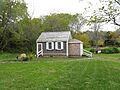
- Mashpee One Room Schoolhouse: Built in 1831, you can visit it from June to October.
- Mashpee National Wildlife Refuge: Established in 1995, this area protects salt marshes, cranberry bogs, forests, and swamps. It's home to animals like New England Cottontail rabbits, white-tailed deer, red foxes, and bald eagles.
- Quashnet Conservation Area: A large area of woodlands and wildlife, it's the biggest undeveloped forest on Cape Cod.
People of Mashpee
| Historical population | ||
|---|---|---|
| Year | Pop. | ±% |
| 1870 | 348 | — |
| 1880 | 346 | −0.6% |
| 1890 | 298 | −13.9% |
| 1900 | 303 | +1.7% |
| 1910 | 270 | −10.9% |
| 1920 | 242 | −10.4% |
| 1930 | 361 | +49.2% |
| 1940 | 434 | +20.2% |
| 1950 | 438 | +0.9% |
| 1960 | 867 | +97.9% |
| 1970 | 1,288 | +48.6% |
| 1980 | 3,700 | +187.3% |
| 1990 | 7,884 | +113.1% |
| 2000 | 12,946 | +64.2% |
| 2010 | 14,006 | +8.2% |
| 2020 | 15,060 | +7.5% |
| 2023* | 15,396 | +2.2% |
| * = population estimate. Source: United States Census records and Population Estimates Program data. | ||
The number of people living in Mashpee year-round has almost doubled since 1990. In 2010, there were 14,006 people living in the town. Most residents (about 84%) were White. About 6% were Native American, and 4% were African American.
The average age in Mashpee was 41 years old. About 24.7% of the population was under 18.
Learning in Mashpee
Mashpee has its own school system for about 1,700 students.
Mashpee Public Schools
- Kenneth C. Coombs School (Kindergarten to Grade 2)
- Quashnet School (Grades 3 to 6)
- Mashpee Middle-High School (Grades 7 to 12)
The middle school and high school are in the same building, but the middle school has its own section. Before Mashpee High School opened in 1996, students from Mashpee went to Falmouth High School.
Mashpee's sports teams are called the Falcons, and their colors are royal blue, white, and black. They play in the South Shore League. The Mashpee High School football team is very successful, having won four state championships (2011, 2015, 2016, 2017).
Other School Options
High school students can also attend Cape Cod Regional Technical High School in Harwich for free. There are also private Catholic high schools nearby, like Bishop Stang High School in Dartmouth and Pope John Paul II High School in Hyannis.
Other private schools in nearby towns include Falmouth Academy in Falmouth and Cape Cod Academy in Barnstable. Tabor Academy is a private boarding school in Marion.
A Wampanoag language immersion school, called Wôpanâôt8ây Pâhshaneekamuq, was expected to open in Mashpee in 2016. It teaches preschool students in the Wampanoag language.
Famous People from Mashpee
- Jessie Little Doe Baird: A Wampanoag historian and linguist known for helping to bring back the Wampanoag language.
- Jamaal Branch: A former NFL football player who attended Falmouth High School.
- Melvin Coombs: A Wampanoag dancer and educator, born and raised in Mashpee.
- Carlo D'Este: A military historian who lived in New Seabury.
- Erik Erikson: A famous psychologist known for his ideas about how people develop socially.
- Adrian Haynes: A former Chief of the Wampanoag Nation, born in Mashpee.
- Robert Kraft: The owner of the New England Patriots football team, who has a home in Mashpee.
- Matt Malone: An American Jesuit and journalist.
- Dana Mohler-Faria: Former President of Bridgewater State University.
- Paula Peters: A Mashpee Wampanoag Tribe activist, educator, and journalist.
- William Rosenberg: The person who started Dunkin' Donuts, who passed away in Mashpee in 2002.
Images for kids
-
Mashpee Town Hall
-
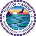
Seal of Mashpee, Massachusetts
-

Flag of Mashpee, Massachusetts
-
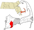
Location of Mashpee in Barnstable County
-
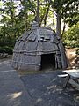
Avant House of the Wampanoag people
-

The "Old Indian Meeting House"
-
Monomoscoy Island in 2012
-
Mashpee One Room Schoolhouse
See also
 In Spanish: Mashpee (Massachusetts) para niños
