Dartmouth, Massachusetts facts for kids
Quick facts for kids
Dartmouth, Massachusetts
Apponeganset
|
||
|---|---|---|
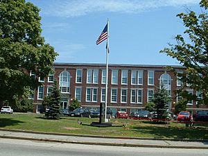
Dartmouth Town Hall
|
||
|
||
| Motto(s):
Utile Dulci (Latin)
"Service Through Kindness and Peaceful Means" |
||
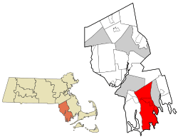
Location in Bristol County in Massachusetts
|
||
| Country | United States | |
| State | Massachusetts | |
| County | Bristol | |
| Settled | 1652 | |
| Incorporated | 1664 | |
| Government | ||
| • Type | Representative town meeting | |
| Area | ||
| • Total | 97.5 sq mi (252.6 km2) | |
| • Land | 60.9 sq mi (157.8 km2) | |
| • Water | 36.6 sq mi (94.8 km2) | |
| Elevation | 125 ft (38 m) | |
| Population
(2020)
|
||
| • Total | 33,783 | |
| • Density | 346.39/sq mi (133.741/km2) | |
| Time zone | UTC−5 (Eastern) | |
| • Summer (DST) | UTC−4 (Eastern) | |
| ZIP Codes |
02747–02748, 02714
|
|
| Area codes | 508/774 | |
| FIPS code | 25-16425 | |
| GNIS ID | 0618279 | |
Dartmouth is a town located on the coast in Bristol County, Massachusetts. Its name in the Massachusett is Apponeganset. Dartmouth was one of the first places in Southeastern Massachusetts to be settled by Europeans in 1652.
The town is part of New England's farm coast. This area has many historic coastal villages, vineyards, and farms. Dartmouth celebrated its 350th year as an official town on June 8, 2014. It is also part of the Massachusetts South Coast.
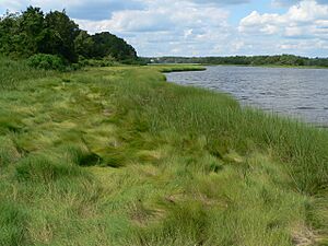
The northern part of Dartmouth has large shopping areas. The southern part of town is next to Buzzards Bay. Many rivers and ponds are also in Dartmouth, like Lake Noquochoke and the Slocums River. The town has working farms and a vineyard. Many of these farms are protected by the town and state.
The southern part of Dartmouth is a busy place for fishing and boating. From its coast, you can see the Elizabeth Islands and Cuttyhunk. The New Bedford Yacht Club in Padanaram hosts a big boat race every two years. This area has been a popular summer spot for many years. Some well-known areas in South Dartmouth are Nonquitt and Round Hill. In 2020, about 33,783 people lived in Dartmouth year-round.
Dartmouth is the third-largest town in Massachusetts by land area. Only Plymouth and Middleborough are larger. The distance from Dartmouth's northern border to Buzzards Bay in the south is about 16 miles (26 km). Several villages are located within the town, including Hixville, Bliss Corner, and Padanaram.
Dartmouth shares borders with Westport to the west and New Bedford to the east. To the north are Freetown and Fall River. To the south are Buzzards Bay and the Atlantic Ocean. You can take boat shuttles from nearby areas to Martha's Vineyard and Cuttyhunk Island.
The local weekly newspapers are The Dartmouth/Westport Chronicle and Dartmouth Week. Dartmouth is a sister city with Lagoa in the Azores, Portugal.
Contents
Why is it Called Dartmouth?
The town of Dartmouth is likely named after Dartmouth, England. This might be because Bartholomew Gosnold, an early European explorer, sailed to America from Dartmouth, England. Another reason could be that the Pilgrims stopped in Dartmouth, England, for ship repairs.
Dartmouth's Story
Early Times
Before the 1600s, the land that is now Dartmouth was home to the Wampanoag Native Americans. They were part of the Algonquian language family. Their settlements were all over southeastern Massachusetts and Rhode Island. It is thought that about 12,000 Wampanoag people lived here.
The Wampanoag lived in this area for a thousand years before Europeans arrived. In John Winthrop's journal, he called the local tribes the Nukkehkammes. In 1602, the English explorer Bartholomew Gosnold landed on Cuttyhunk Island. He explored the area, including Round Hill, which he named Hap's Hill. He described Dartmouth as having fields of flowers, beech and cedar trees, and deer. He also saw the Apponagansett River and the Acushnet River.
After the Pilgrims settled in Plymouth, colonists became interested in this region. A meeting was held to officially buy the land.
Old Dartmouth and the Land Purchase
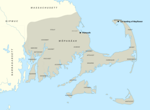
On March 7, 1652, English colonists met with the Wampanoag tribe. They purchased a large area called Old Dartmouth. This region was about 115,000 acres (465 km2). It now includes the towns of Dartmouth, Acushnet, New Bedford, Fairhaven, and Westport.
The Wampanoag were represented by Chief Ousamequin (also known as Massasoit) and his son Wamsutta. The English buyers were important people from Plymouth Colony, like Myles Standish. One buyer, John Cooke, came to America on the Mayflower. He was a Baptist minister who settled in Old Dartmouth after leaving Plymouth due to religious differences.
The land was bought for items like:
- 30 yards of cloth
- 8 moose skins
- 15 axes and 15 hoes
- 15 pairs of pants
- 8 blankets and 2 kettles
- 1 cloak
- Money and other goods
The Europeans believed they fully owned the land after this deal. However, the Wampanoag saw land ownership differently. For them, it was about sharing rights to hunt, fish, and farm, not about owning the land exclusively. This led to disagreements because the deed didn't clearly define the borders.
Massasoit's younger son, Metacomet, questioned the sale. He said he had not agreed to it. New boundaries were drawn up, and Chief Massasoit finally approved them in 1665. About six months after the purchase, English immigrants began to settle in Dartmouth. The town officially became incorporated in 1664.
Thirty-four people from Plymouth Colony bought the town. But most of them never lived in Dartmouth. Only ten families actually moved there. These families included the Cooks, Howlands, and Soules.
Quakers in Dartmouth
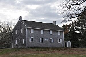
Many early European settlers in Dartmouth were members of the Religious Society of Friends, also known as Quakers. They faced unfair treatment in the Puritan communities of Plymouth Colony. The Massachusetts Bay Colony even banned Quakers in 1656.
When the Massachusetts Bay Colony took over Plymouth Colony in 1691, Quakers were already the majority in Old Dartmouth. In 1699, with help from Peleg Slocum, the Quakers built their first meeting house. This is where the Apponegansett Meeting House stands today.
At first, Old Dartmouth did not have big town centers. Instead, it had separate farms and small villages like Russells' Mills. People liked their independence from Plymouth Colony. They did not want a large enough population for the Plymouth court to send them a minister. Today, there are still Quaker meeting houses in Dartmouth, including the Apponegansett Meeting House, which is a historic site.
King Philip's War
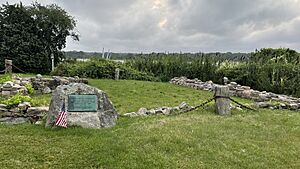
As more Europeans moved in, their relationship with the Native Americans in New England became difficult. The colonists took more land and did not always respect the terms of the Old Dartmouth Purchase. This led to King Philip's War in 1675.
In this war, Wampanoag tribes, along with the Narragansett and Nipmuc, attacked European settlements like Old Dartmouth. Europeans in Old Dartmouth took shelter in strong homes called garrisons. These included John Russell's garrison in Padanaram.
Revolutionary War Efforts
During the Revolutionary War, Dartmouth played a part. One of the riders who spread the alarm from Paul Revere rode through Dartmouth. On April 21, 1775, three companies of Dartmouth Minutemen marched to a military camp in Roxbury. They joined 20,000 other soldiers.
In 1778, British troops attacked the village of Padanaram. The village was then known as Akin's Landing. The British burned down most of the village, focusing on the properties of Elihu Akin. They targeted Akin because he had made some British supporters leave Dartmouth. Elihu Akin lost almost everything and never recovered financially. The damage to the town from the raid cost a lot of money at the time. After the war, Padanaram was called Akin's Wharf for 20 years to honor Elihu.
In 1793, Davolls General Store was opened in the Russells Mills area.
Civil War Contributions
Before the War
In the years before the Civil War, Dartmouth was involved in whaling. The town also had various industries. In 1855, Dartmouth had a cotton mill, salt works, and factories making wagons and sleighs. There were also tanneries and shoemakers. The town had many farm animals, including sheep, cows, and pigs.
Dartmouth During the War
On May 16, 1861, Dartmouth held its first town meeting about the Civil War. The town leaders stated their support for the United States government. They promised to help defend the country's freedom and flag.
When the war started, Dartmouth men joined different regiments. In 1862, Dartmouth met its quota for soldiers requested by Washington, D.C. The town voted to pay volunteers for their service. Many Dartmouth soldiers fought in important battles. For example, some were at the Second Battle of Bull Run and the Battle of Fredericksburg.
In 1863, the town voted to raise money to help the families of soldiers. Dartmouth soldiers also fought at the Battle of Gettysburg.
David Lewis Gifford was a soldier from Dartmouth who received the Medal of Honor. He joined the 4th Massachusetts Cavalry Regiment. During one event, a ship got stuck, leaving 400 people in danger. Gifford and four other men used a small boat to rescue the stranded soldiers.
In 1864, Dartmouth continued to support the war effort. The town voted to raise money to get more men to serve. Many Dartmouth men were wounded or died in battles like Battle of Spotsylvania Court House and Battle of Cold Harbor. During the 1864 election, most people in Dartmouth voted to reelect Abraham Lincoln.
Modern Dartmouth
The Watuppa Branch railroad began serving Dartmouth in 1875. In the late 1800s, Dartmouth's coastline became a popular summer spot for wealthy people.
Lincoln Park opened in 1894 as an amusement park. It had rides like the wooden roller coaster called The Comet.
Round Hill was a site for important research in the 1900s. Scientists from MIT studied radio and microwaves there. In 1933, physicist Robert J. Van de Graaff built the world's largest air-insulated Van de Graaff generator there. This generator is now at the Museum of Science (Boston).
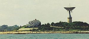
Round Hill was also home to the Green Mansion, the estate of "Colonel" Edward Howland Robinson Green. After the Colonel died in 1936, his sister inherited the estate. In 1948, she gave the entire estate to MIT. MIT used it for experiments with microwaves and lasers. A giant antenna, which was a landmark for sailors, was built on top of a water tank. This antenna was taken down in 2007.
Another antenna was built near the mansion. It was used to develop the Ballistic Missile Early Warning System. MIT used Round Hill until 1964. Then, it was sold to the Society of Jesus (Jesuits), who used it as a retreat house. In 1981, much of the land was sold to developers. Today, it is a private residential community with a golf course.
In 1980, Sunrise Bakery and Coffee Shop opened its first store in Dartmouth.
Dartmouth's Landscape
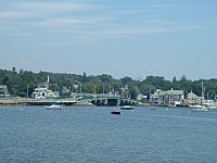
Dartmouth covers a total area of about 252.6 square kilometers (97.5 square miles). About 157.8 square kilometers (60.9 square miles) is land, and 94.8 square kilometers (36.6 square miles) is water. This makes it the third-largest town by area in Massachusetts.
You can reach Dartmouth by I-195 and US 6. These roads run through the northern business part of town.
Dartmouth includes part of the Southeastern Massachusetts Bioreserve. This area has many protected forests. These forests connect to the Freetown-Fall River State Forest.
Many rivers flow through Dartmouth from north to south, such as the Slocums River. Dartmouth is divided into two main parts: North Dartmouth (ZIP code 02747) and South Dartmouth (ZIP code 02748).
The town is bordered by Westport to the west and New Bedford to the east. To the north are Fall River and Freetown. To the south are Buzzards Bay and the Atlantic Ocean. The highest point in Dartmouth is about 78 meters (256 feet) above sea level.
Nature and Conservation
The Lloyd Center for Environmental Studies in South Dartmouth teaches people about aquatic environments. It is located across the mouth of the Slocums River from Demarest Lloyd State Park, a popular state beach.
The Dartmouth Natural Resource Trust (DNRT) is a non-profit group that works to protect Dartmouth's natural areas. Since 1971, the trust has protected 5,400 acres of land. As of 2020, they own 1,800 acres in Dartmouth. This includes 35 miles of hiking trails and paths along the ocean and rivers. The DNRT organizes activities like photography tours, outdoor yoga, and bird watching. Many Boy Scouts have completed projects through the DNRT.
Getting Around Dartmouth
Roads
Major roads like Route 140 and Route 24 are just outside Dartmouth. They connect to Boston and areas to the north. I-195 and US 6 go directly through Dartmouth.
Buses
The Southeastern Regional Transit Authority provides bus services in Dartmouth. Buses connect different parts of Dartmouth and go to nearby cities like New Bedford and Fall River. From these cities, you can connect to other bus services that go to places like Cape Cod and Boston.
Water Travel
Even though Dartmouth is on Buzzard's Bay, it doesn't have major water transportation itself. However, nearby cities like Fall River and New Bedford offer ferry services. These ferries can take you to places like Martha's Vineyard and Cuttyhunk.
Trains
Currently, Dartmouth does not have train connections. However, new MBTA commuter rail stations are being built in Fall River and New Bedford. Once finished, these will offer train connections to cities like Taunton and Boston.
A short part of a railway, called the North Dartmouth Industrial Railroad, runs through northern Dartmouth. It is mainly used for freight trains.
Population of Dartmouth
| Historical population | ||
|---|---|---|
| Year | Pop. | ±% |
| 1850 | 3,868 | — |
| 1860 | 3,883 | +0.4% |
| 1870 | 3,367 | −13.3% |
| 1880 | 3,430 | +1.9% |
| 1890 | 3,122 | −9.0% |
| 1900 | 3,669 | +17.5% |
| 1910 | 4,378 | +19.3% |
| 1920 | 6,493 | +48.3% |
| 1930 | 8,778 | +35.2% |
| 1940 | 9,011 | +2.7% |
| 1950 | 11,115 | +23.3% |
| 1960 | 14,607 | +31.4% |
| 1970 | 18,800 | +28.7% |
| 1980 | 23,966 | +27.5% |
| 1990 | 27,244 | +13.7% |
| 2000 | 30,666 | +12.6% |
| 2010 | 34,032 | +11.0% |
| 2020 | 33,783 | −0.7% |
| 2022 | 33,406 | −1.1% |
Source: United States Census records and Population Estimates Program data. |
||
Libraries in Dartmouth
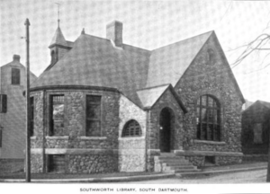
Dartmouth started its public library services in 1895. Today, there are two libraries: the Southworth (Main) Library in South Dartmouth and the Dartmouth Public Library—North Branch. The Southworth Library is part of a network that allows it to share books with other libraries.
The older Southworth Library was founded in 1878 by a local pastor. Its building was bought in 1888 with money from John Haywood Southworth, who also gave 2,500 books. At that time, you had to buy a 50-cent card to borrow books. The town of Dartmouth took over the library in 1927. By 1958, the building was too small for all the books. In 1967, a new library was approved to be built on Dartmouth Street. In 2008, Dartmouth spent about $25 per person on its public libraries. There was also a Dartmouth Free Public Library in Russells Mills, which mainly served children.
Schools in Dartmouth
Dartmouth has its own school department. The town has four elementary schools: Joseph P. DeMello, George H. Potter, James M. Quinn, and Andrew B. Cushman. There is one middle school, located in the old high school building. The new Dartmouth High School opened in 2002. Its colors are green and white, and its fight song is "Glory to Dartmouth." The school's mascot is the "Indians," with a brave's head logo representing the Native Americans who first lived in the area.
Besides Dartmouth High, students can also attend Greater New Bedford Regional Vocational-Technical High School or Bristol County Agricultural High School. Dartmouth also has private schools like Bishop Stang and Friends Academy.
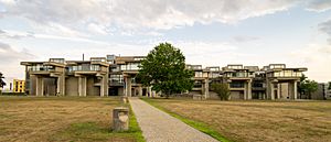
Since the 1960s, Dartmouth has been home to the University of Massachusetts Dartmouth campus. This campus was created in 1962 by combining two technology colleges. Its unique design was created by architect Paul Rudolph. The school was known as Southeastern Massachusetts University until 1991, when it joined the University of Massachusetts system. The campus has grown over the years and has centers in Fall River and New Bedford.
Culture in Dartmouth
Many famous artists have connections to Dartmouth, including Beatrice Chanler and Pete Souza.
Dartmouth Community Band
The Dartmouth Community Band started in 1974. The band plays concerts in Apponagansett Park during the summer. These concerts are part of the Dartmouth Parks and Rec. Summer Concert Series.
Famous People from Dartmouth
- Frederic Vaughan Abbot (1858–1928), U.S. Army general (summer resident)
- Naseer Aruri (1934–2015), expert on Middle East politics and human rights
- Ezekiel Cornell (1732–1800), member of Continental Congress
- Henry H. Crapo (1804–1869), 14th Governor of Michigan
- William W. Crapo (1830–1926), U.S. House Representative
- David Lewis Gifford (1844–1904), U.S. Medal of Honor recipient
- Arthur Golden (born 1956), author of Memoirs of a Geisha (summer resident)
- Edward Howland Robinson Green (1868–1936), a businessman
- Edith Ellen Greenwood (born 1920), first female recipient of the Soldier's Medal
- Huda Kattan (born 1983), CEO of Huda Beauty
- Téa Leoni (born 1966), actress (summer resident)
- Arthur Lynch (born 1990), former football player
- Lewis Lee Millett Sr., recipient of Congressional Medal of Honor (Korean War)
- Brian Rose (born in 1976), former Major League Baseball player
- Philip Sheridan (1831–1888), Union general in the American Civil War (died at his summer home)
- Peleg Slocum (1654–1733), Quaker and Dartmouth landowner
- Pete Souza (born 1954), former Chief Official White House Photographer, grew up in Dartmouth
- Jordan Todman (born 1990), former football player
- Bernard Trafford (1871–1942), football player and banker
- Benjamin Tucker (1854–1939), writer and translator
See also
 In Spanish: Dartmouth (Massachusetts) para niños
 | James Van Der Zee |
 | Alma Thomas |
 | Ellis Wilson |
 | Margaret Taylor-Burroughs |


