
Westport, Massachusetts facts for kids
Quick facts for kids
Westport, Massachusetts
Acoaxet
|
||
|---|---|---|

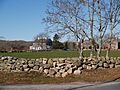
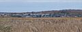
Stone wall and field scene, Westport
|
||
|
||

Location in Bristol County in Massachusetts
|
||
| Country | United States | |
| State | Massachusetts | |
| County | Bristol | |
| Settled | 1670 | |
| Incorporated | 1787 | |
| Government | ||
| • Type | Open town meeting | |
| Area | ||
| • Total | 64.4 sq mi (166.8 km2) | |
| • Land | 50.1 sq mi (129.6 km2) | |
| • Water | 14.3 sq mi (37.1 km2) | |
| Elevation | 50 ft (15 m) | |
| Population
(2020)
|
||
| • Total | 16,339 | |
| • Density | 253.71/sq mi (97.96/km2) | |
| Time zone | UTC-5 (Eastern) | |
| • Summer (DST) | UTC-4 (Eastern) | |
| ZIP code |
02790
|
|
| Area code(s) | 508 / 774 | |
| FIPS code | 25-77570 | |
| GNIS feature ID | 0618287 | |
| Website | http://www.westport-ma.com | |

Westport is a town in Bristol County, Massachusetts, United States. It's known as a "New England town," which means it has a special type of local government. In 2020, about 16,339 people lived here.
The town includes several smaller areas. North Westport is one of them. Other areas are "Westport Point," which has a dock on the Westport River, and "Central Village," where you'll find town offices and shops. "Head of Westport" is at the top of the east branch of the river. The area called "Acoaxet" or "Westport Harbor" is located between the west branch of the river and Rhode Island. This part of Westport is unique because you have to go through Rhode Island to reach it by land.
Westport is part of the South Coast region of Massachusetts. This area includes towns and cities around Buzzards Bay, Mount Hope Bay, and the Sakonnet River.
Contents
Westport's Past: A Look at Its History
Westport got its name because it was the westernmost port in the Massachusetts Bay Colony. English settlers first arrived here in 1670. The Sisson family was among the first to settle this area, which was then part of a larger region called Old Dartmouth. The river and surrounding land were originally known as "Coaksett." Today, the name "Acoaxet" refers to the community in the southwestern part of town, along the western branch of the Westport River.
Challenges and Growth in Early Westport
Like many places in the region, Westport faced challenges from Wampanoag groups during a conflict known as King Philip's War. Despite this, the town grew. Several small mills were built along the Westport River, helping the local economy. In 1787, Westport became its own town, separating from Dartmouth, just like New Bedford did.
Paul Cuffee: A Local Hero
In the late 1700s and early 1800s, Paul Cuffee, a Quaker businessman and sea captain, lived in Westport. He was a patriot and worked to end slavery. Cuffee built a shipyard on the Westport River. He was of Wampanoag and Ashanti descent and became one of the wealthiest free men of color in the United States at that time. He later helped free Black people move to Sierra Leone in West Africa.
Westport's Economy and Modern Day
Cotton mills once operated along the river, with the largest one near Lake Noquochoke. The famous Macomber turnip has roots in Westport, from seeds brought here in 1876. During World War II, a coastal defense base was built on Gooseberry Island. Today, Westport is mostly a residential town with a large farming community. Horseneck Beach State Reservation, near Gooseberry Island, is a popular spot for summer fun.
Westport's Location and Natural Features

Westport covers about 64.4 square miles (166.8 square kilometers). About 50.1 square miles (129.6 square kilometers) of this is land, and 14.3 square miles (37.1 square kilometers) is water. Much of the water area comes from the Watuppa Ponds, which are on the border with Fall River, and Westport Harbor. This is where the two branches of the Westport River meet before flowing into Rhode Island Sound.
Neighboring Towns and Cities
Westport is surrounded by several other places. Fall River is to the northwest and west. Dartmouth is to the east. To the south is Rhode Island Sound. To the west, you'll find Little Compton, Adamsville, and Tiverton, all in Rhode Island. Westport is about 30 miles (48 km) southeast of Providence, Rhode Island, and about 60 miles (97 km) south of Boston.
Unique Areas Within Westport
Besides the main town, Westport has several unofficial areas. These include Head of Westport, South Westport, Westport Point, Central Village, and North Westport (which used to be called Westport Factory). Westport Harbor, also known as Acoaxet, is special because you can only reach it by land by going through Adamsville, Rhode Island, due to the west branch of the Westport River.
Westport's Weather: Seasons and Storms

Westport experiences all four seasons, each with its own weather patterns.
Winter Weather in Westport
Winter usually starts in mid-December and lasts until mid-March. The most snow falls in January and February. Temperatures during winter typically range from highs in the 30s°F (around 0°C) to lows in the 20s°F (around -5°C). January is the coldest month, with temperatures sometimes dropping into the teens or even single digits.
Spring Weather in Westport
Spring arrives in late March and ends in mid-May. March and April often bring rain, while May sees a mix of sun and rain. Temperatures in spring average highs in the 50s-60s°F (10-15°C) and lows in the 40s-50s°F (5-10°C).
Summer Weather in Westport
Summer begins in late May and continues until mid-September, usually with lots of sunshine. Hurricanes and tropical storms can sometimes affect Westport in late August and September. Summer temperatures average highs in the 80s°F (around 27°C) and lows in the 60s-70s°F (15-20°C). Mid-July is often the hottest time, with temperatures sometimes reaching the 90s°F (over 32°C).
Fall Weather in Westport
Fall, or Autumn, starts in late September and ends in early December. These months usually bring sunny, cool, and crisp days. Temperatures typically range from the 50s°F (10-15°C) during the day to the 30s-40s°F (0-10°C) at night.
Tropical Storms and Hurricanes
Tropical storms and hurricanes sometimes hit or come close to Westport, most often in mid to late August and September. The last major tropical system to affect Westport was Hurricane Sandy on October 29, 2012. It brought winds of about 70 mph (113 km/h) and heavy rain, causing power outages for many. However, power was mostly restored within a day.
| Climate data for Westport, Massachusetts | |||||||||||||
|---|---|---|---|---|---|---|---|---|---|---|---|---|---|
| Month | Jan | Feb | Mar | Apr | May | Jun | Jul | Aug | Sep | Oct | Nov | Dec | Year |
| Record high °F (°C) | 66 (19) |
69 (21) |
78 (26) |
91 (33) |
98 (37) |
100 (38) |
102 (39) |
107 (42) |
94 (34) |
87 (31) |
79 (26) |
70 (21) |
107 (42) |
| Mean daily maximum °F (°C) | 37.6 (3.1) |
37.8 (3.2) |
45.1 (7.3) |
54.7 (12.6) |
65.5 (18.6) |
74.5 (23.6) |
80.1 (26.7) |
78.6 (25.9) |
72.1 (22.3) |
64.6 (18.1) |
51.8 (11.0) |
41.2 (5.1) |
58.5 (14.7) |
| Daily mean °F (°C) | 30.6 (−0.8) |
30.7 (−0.7) |
38.1 (3.4) |
47.1 (8.4) |
57.4 (14.1) |
66.4 (19.1) |
72.3 (22.4) |
71.2 (21.8) |
64.6 (18.1) |
54.9 (12.7) |
45.0 (7.2) |
34.3 (1.3) |
51.1 (10.6) |
| Mean daily minimum °F (°C) | 23.5 (−4.7) |
23.5 (−4.7) |
31.1 (−0.5) |
39.6 (4.2) |
49.3 (9.6) |
58.3 (14.6) |
64.8 (18.2) |
63.9 (17.7) |
57.0 (13.9) |
47.3 (8.5) |
38.1 (3.4) |
27.5 (−2.5) |
43.5 (6.4) |
| Record low °F (°C) | −9 (−23) |
−11 (−24) |
1 (−17) |
16 (−9) |
28 (−2) |
36 (2) |
45 (7) |
43 (6) |
32 (0) |
23 (−5) |
10 (−12) |
−5 (−21) |
−11 (−24) |
| Average precipitation inches (mm) | 3.98 (101) |
3.50 (89) |
4.21 (107) |
3.82 (97) |
3.23 (82) |
3.27 (83) |
2.91 (74) |
4.25 (108) |
3.27 (83) |
3.31 (84) |
4.06 (103) |
4.06 (103) |
43.82 (1,113) |
| Source 1: Western Regional Climate Center (normals 1958–1992) | |||||||||||||
| Source 2: The Weather Channel (extremes) | |||||||||||||
Getting Around: Transportation in Westport

You can reach Westport by major roads like Interstate 195, U.S. Route 6, and Massachusetts Route 177. Route 177 ends where it meets Route 6 on the eastern side of Westport. Massachusetts Route 88 is the longest state highway completely within one town in Massachusetts. It connects I-195 (at exit 16) to Horseneck Beach State Reservation.
Bus and Rail Services
Bus service is available along Route 6 through the Southeastern Regional Transit Authority (SRTA). In the summer, this bus service extends to Horseneck Beach. You can find more regional bus services in Fall River. For regional train service, you can go to Middleborough/Lakeville or Providence. There are plans to bring South Coast Rail service to Fall River and New Bedford by 2024.
Airports Near Westport
The closest airport is New Bedford Regional Airport, about 8 miles (13 km) away. For national flights, you can go to T. F. Green Airport in Warwick, Rhode Island, which is about 36 miles (58 km) away.
Future Rail Connections
Two new MBTA commuter rail stations are being built in Fall River as part of the South Coast Rail project. Once finished, these will connect the South Coast to cities like Taunton, Brockton, Braintree, and Boston by train.
Freight Rail in Westport
A short railway line, known as the North Dartmouth Industrial railroad or the Watuppa Branch, runs through northern Westport. It connects Westport through Dartmouth to New Bedford, where it links with the New Bedford Secondary. The main company that operates freight trains in Westport is Bay Colony Railroad.
Learning in Westport: Schools and Education

Westport has its own school system with three schools. Alice A. Macomber School serves pre-school and kindergarten students. Westport Elementary School, located near the Head of Westport, is for grades 1-4. Westport Middle/High School teaches students from grades 5 to 12. Grades 5-8 are part of Westport Middle School, and grades 9-12 are Westport High School. High school students can earn special academy certificates in addition to their diplomas if they complete enough credits in certain subjects. This system is similar to how universities offer degrees.
Westport Wildcats: School Sports
The school's sports teams are called the Westport Wildcats. They have won many championships in the Mayflower League. The Wildcats are one of the few teams in their league to win multiple championships in every sport. Their mascot is the Wildcat, and their colors are brown, white, and yellow. These colors are a nod to an older league where Westport used colors inspired by Ivy League universities, with brown and white coming from Brown University. Westport High School had a 94% graduation rate in 2013.
Other Education Options
High school students can also choose to attend Diman Regional Vocational Technical High School in Fall River or Bristol County Agricultural High School in Dighton, both free of charge. Juniors and seniors can take college classes at UMass Dartmouth or Bristol Community College in Fall River. This allows them to earn both high school and college credits at the same time. Internships and independent study programs are also available.
Private Schools in Westport
Westport has one private school, Montessori School of the Angels, which teaches grades 1-8. It's located in the Westport Factory area. This school used to be called Saint Joseph's Montessori and was in Fall River. The building it's in used to be Saint George's School, which closed due to funding issues. Many students also attend private and charter schools in Fall River and Dartmouth, such as Bishop Connolly High School in Fall River and Bishop Stang High School in North Dartmouth.
Who Lives in Westport: Demographics
| Historical population | ||
|---|---|---|
| Year | Pop. | ±% |
| 1850 | 2,795 | — |
| 1860 | 2,767 | −1.0% |
| 1870 | 2,724 | −1.6% |
| 1880 | 2,894 | +6.2% |
| 1890 | 2,599 | −10.2% |
| 1900 | 2,890 | +11.2% |
| 1910 | 2,928 | +1.3% |
| 1920 | 3,115 | +6.4% |
| 1930 | 4,408 | +41.5% |
| 1940 | 4,134 | −6.2% |
| 1950 | 4,989 | +20.7% |
| 1960 | 6,641 | +33.1% |
| 1970 | 9,791 | +47.4% |
| 1980 | 13,763 | +40.6% |
| 1990 | 13,852 | +0.6% |
| 2000 | 14,183 | +2.4% |
| 2010 | 15,532 | +9.5% |
| 2020 | 16,339 | +5.2% |
| 2023 | 16,461 | +0.7% |
Source: United States Census records and Population Estimates Program data. |
||
In 2010, there were 15,532 people living in Westport, with 5,386 households and 4,082 families. The town had about 283.4 people per square mile (109.4 people per square kilometer). There were 6,143 homes, with about 122.7 homes per square mile (47.4 homes per square kilometer).
Population Makeup
Most of the people in Westport were White (98.01%). A smaller number were African American (0.17%), Native American (0.14%), Asian (0.49%), or Pacific Islander (0.02%). Some people identified as other races (0.37%) or two or more races (0.79%). About 0.69% of the population was Hispanic or Latino.
Households and Families
Of the households in Westport, 29.0% had children under 18 living with them. Most households (62.9%) were married couples living together. About 9.0% were female householders without a husband present, and 24.2% were not families. About 19.7% of all households were individuals, and 8.9% had someone living alone who was 65 or older. The average household had 2.62 people, and the average family had 3.01 people.
Age Distribution and Income
The population in Westport was spread out by age. About 21.6% were under 18, 6.7% were 18 to 24, 28.0% were 25 to 44, 29.0% were 45 to 64, and 14.6% were 65 or older. The average age was 41 years. For every 100 females, there were about 96.0 males.
The average income for a household in Westport was $55,436, and for a family, it was $64,568. Men had an average income of $41,890, while women had $30,921. The per capita income for the town was $25,281. About 3.7% of families and 4.9% of the total population lived below the poverty line. This included 5.5% of those under 18 and 7.9% of those 65 or older.
Famous People from Westport
- Thomas Church Brownell (1779–1865), who founded Trinity College.
- Paul Cuffee, a well-known businessman and abolitionist.
- Ruby Devol Finch, a talented watercolor artist.
- Black Francis, the songwriter, lead singer, drummer, and rhythm guitarist for the band Pixies.
- Allen Levrault, a former Major League Baseball player for the Milwaukee Brewers and Florida Marlins.
- Wendi Nix, an ESPN analyst for college football and the NFL.
- Edwin Slade, a Wisconsin State Assemblyman and businessman.
- Paul Bedard, a former lifeguard at Horseneck Beach and host of the show Gator Boys.
Images for kids
-
Stone wall and field scene, Westport
-
Seal of Westport, Massachusetts
-
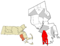
Location in Bristol County in Massachusetts
-
Westport River in winter
-

Fall foliage on the Westport River, 2019
-
The Fontaine Bridge carries Route 88 over the Westport River.
-

Westport High School
See also
 In Spanish: Westport (Massachusetts) para niños
