
Hurricane Sandy (2012) facts for kids
| Category 3 major hurricane (SSHWS/NWS) | |

Hurricane Sandy at peak intensity just before landfall in Cuba on October 25
|
|
| Formed | October 22, 2012 |
|---|---|
| Dissipated | November 2, 2012 |
| (Extratropical after October 29) | |
| Highest winds | 1-minute sustained: 115 mph (185 km/h) |
| Lowest pressure | 940 mbar (hPa); 27.76 inHg |
| Fatalities | 233 total |
| Damage | $68.7 billion (2012 USD) (Fourth-costliest hurricane in U.S. history) |
| Areas affected | Greater Antilles, Bahamas, most of the eastern United States (especially the coastal Mid-Atlantic States), Bermuda, eastern Canada |
| Part of the 2012 Atlantic hurricane season | |
Hurricane Sandy was a very large and powerful storm that formed in the Atlantic Ocean in October 2012. It was a type of storm called a tropical cyclone, which means it formed over warm ocean waters. Sandy became the biggest Atlantic hurricane ever measured by its width, with its strong winds reaching out 1,100 miles (1,800 km).
The hurricane hit many places, including parts of the Caribbean Sea, the eastern United States, and eastern Canada. It was the eighteenth named storm and tenth hurricane of the 2012 Atlantic hurricane season. Sandy started as a tropical wave (a low-pressure area) in the western Caribbean Sea on October 22. It quickly grew stronger, first becoming a tropical depression and then a tropical storm just six hours later.
Sandy moved slowly north and kept getting stronger. On October 24, it hit Jamaica as a hurricane. Then, it made a second landfall in Cuba, where it became a very strong Category 3 hurricane.
Sadly, Hurricane Sandy caused many deaths and a lot of damage. At least 233 people died because of the storm. Most of these deaths happened in the Caribbean and the United States. Sandy caused about $68.7 billion in damage, making it one of the most expensive hurricanes in U.S. history.
Contents
How Hurricane Sandy Formed and Traveled
Sandy's Early Days
On October 19, 2012, a tropical wave was moving west across the eastern Caribbean Sea. This wave had a large area of low pressure, which means the air pressure was much lower than normal. Weather experts thought it might soon become a more organized storm. By October 20, the system started to get more organized, just as predicted.
The National Hurricane Center (NHC) watched it closely. They said there was a high chance it would become a tropical cyclone within two days. The next day, the thunderstorms linked to the system were small. But the air pressure stayed low, which meant the storm still had a good chance to grow. The thunderstorms then got bigger, and the system slowed down and even stopped moving for a short time.
Becoming a Tropical Storm
At 3:00 PM UTC on October 22, the NHC officially named the storm Tropical Depression Eighteen. It was located about 320 miles (515 km) south of Kingston, Jamaica.
When the tropical depression formed, it was in an area where the winds were not very strong. This meant the storm could grow without being pulled apart. The area was also good for the storm to get stronger. Later on October 22, a special plane called a Hurricane Hunters aircraft flew into the storm. It found winds of 40 miles per hour (64 km/h) in a rainband (a band of rain clouds). Because of these strong winds, the NHC upgraded the depression to Tropical Storm Sandy.
Sandy Becomes a Hurricane
The air around Sandy was very moist, which helped the storm get even more organized. By early on October 24, an eye (the calm center of a hurricane) began to form in the middle of the storm. At this time, Sandy was moving slowly north.
At 11:00 AM EDT (3:00 PM UTC) on October 24, the NHC upgraded Sandy to a hurricane. This happened after Hurricane Hunters found winds of 99 miles per hour (159 km/h). At that moment, Sandy was about 65 miles (105 km) south of Kingston, Jamaica.

Sandy first hit land near Kingston, Jamaica, at 3:00 PM EDT (7:00 PM UTC) on October 24. Its winds were about 80 miles per hour (129 km/h). After leaving Jamaica, Sandy got even stronger. It became a Category 2 hurricane with winds of 110 miles per hour (175 km/h).
Sandy made its second landfall in Cuba at 1:25 AM EDT (5:25 AM UTC) on October 25. It hit just west of Santiago de Cuba. When it hit Cuba, Sandy had a clear eye that was over 23 miles (37 km) wide. Its winds reached 135 miles per hour (216 km/h), making it a powerful Category 3 hurricane.
While over land in Cuba, the storm weakened, and its eye disappeared. After Sandy moved away from Cuba, it met dry air and stronger wind shear (winds blowing in different directions). This made the storm less organized. A low-pressure system over Florida then turned the hurricane toward the north-northwest. By early October 26, most of the storm's clouds were to the north of its center, and the storm grew much larger. By October 27, the NHC said that Sandy was starting to change into a "hybrid cyclone," meaning it had both tropical and non-tropical storm features. On October 27, Sandy weakened to a tropical storm for a few hours. But then, it got stronger again and became a Category 1 hurricane.
Getting Ready for Sandy
Caribbean Islands Prepare
When Sandy became a tropical cyclone on October 22, the government of Jamaica issued a tropical storm watch. This meant a tropical storm was possible in the area. Early on October 23, the watch became a tropical storm warning, meaning a tropical storm was expected. Later that day, a hurricane watch was issued, meaning a hurricane was possible. By 3:00 PM UTC on October 23, the hurricane watch was upgraded to a hurricane warning, meaning a hurricane was expected.
The government of Haiti also issued a tropical storm watch, which was later upgraded to a tropical storm warning. For Cuba, a hurricane watch was issued for several provinces on October 23. Just three hours later, this was changed to a hurricane warning, telling people to prepare for a hurricane.
The Bahamas and Bermuda
The government of The Bahamas issued tropical storm watches for many of its islands. These watches were later upgraded to tropical storm warnings for some areas.
On October 26, the Bermuda Weather Service issued a tropical storm watch for Bermuda. This was because Sandy was so large and could affect the island.
United States Prepares


Many public schools in Florida closed on October 26. The Federal Emergency Management Agency (FEMA), a government group that helps with disasters, said they would watch Sandy and help people who needed it.
Weather experts warned that there was a 90% chance the East Coast of the United States would be "slammed" by the storm. Power companies and local governments along the East Coast got ready for long power outages. In New Jersey, where the storm was expected to hit land, power companies told their workers to be ready for longer work shifts.
On October 26, the governor of North Carolina declared a state of emergency for 38 counties. This meant the state could use special resources to prepare and respond. Presidential candidates Mitt Romney and Joe Biden canceled their campaign events because of Sandy. The United States Navy sent more than two dozen ships out to sea from Norfolk Naval Base to keep them safe from the storm.
The mayor of Washington, D.C., and the governors of Pennsylvania, Maryland, and Virginia also declared states of emergency on October 26. In Cape May County, New Jersey, officials told people living on barrier islands (thin strips of land along the coast) to evacuate (leave their homes for safety).
Philadelphia's Mayor Michael Nutter asked people in low-lying areas to leave their homes by October 28. In New York City, officials started the city's coastal emergency plan. The subway system was closed, and people in areas that were flooded by Hurricane Irene in 2011 were told to evacuate. Mayor Michael Bloomberg said some residents should get ready to leave. New York Governor Andrew Cuomo declared a state of emergency for every county in the state. On Long Island, officials in Suffolk County ordered people on Fire Island to evacuate. Governor Cuomo later said that Hurricane Sandy had a bigger impact than Hurricane Katrina.
Connecticut's Governor Dannel Malloy opened the state's Emergency Operations Center on October 26 and signed a Declaration of Emergency the next day. Massachusetts Governor Deval Patrick also declared a state of emergency.
Canada Prepares
The Canadian Hurricane Centre issued its first statement about Sandy on October 25, 2012. One weather model suggested that Sandy might hit the East Coast of the United States and possibly affect Southern Ontario in Canada.
Impact of Hurricane Sandy
| Country | Fatalities | Missing | Damage (in USD) | Sources |
|---|---|---|---|---|
| 131 | 0 | $63 billion (estimated) | ||
| 104 | 15 | >$100 million (estimated) | ||
| 11 | 0 | $2 billion (estimated) | ||
| 2 | 0 | $300 million (estimated) | ||
| 2 | 0 | $100 million (estimated) | ||
| 2 | 0 | $30 million (estimated) | ||
| 1 | 0 | $55.23 million (estimated) | ||
| Total | 253 | 15 | >$65.6 billion (estimated) |
Hurricane Sandy caused a lot of damage and sadly led to many deaths. At least 253 people died across the United States, the Caribbean, Canada, and the Bahamas.
In New York City, the subway system was shut down for days, and some parts of it for months. Many areas lost electricity for days, leaving thousands of homes and businesses in the dark. Thousands of houses were damaged by strong winds and flooding. Hundreds of homes also burned down because firefighters could not reach them due to the storm's effects.
Images for kids
-
Radar image of Hurricane Sandy approaching the Jersey Shore
-
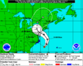
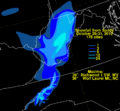
The National Hurricane Center (NHC)'s forecast for the storm as of October 28, 2012
-

White House conference with FEMA and Department of Homeland Security in preparation for arrival of the hurricane.
-
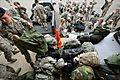
Airmen of the New Jersey National Guard's 108th Wing assemble before being sent to assist at various emergency shelters.
-
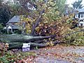
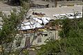
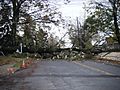
A downed tree in Cheltenham Township, Pennsylvania.
-
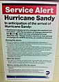
Special MTA service alerts, posted in subway stations on October 26, urged travelers to be alert for future evacuation orders or service suspension announcements.
-

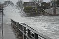
The Brooklyn–Battery Tunnel remained flooded on the Tuesday morning after the storm.
-
Flooding in Marblehead, Massachusetts, caused by Hurricane Sandy on October 29.
-

Connecticut governor Dannel Malloy discusses the hurricane on the phone with President Obama on October 28 from the State Emergency Operations Center
-
Snowfall totals in the Appalachian mountain range (amount in inches)
-
Hurricane Sandy damage in Guantanamo Bay
-
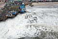
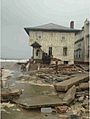
Damage to Casino Pier in Seaside Heights, New Jersey
-
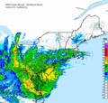
Storm total rainfall for Sandy (2012) across the United States
-

The 180-foot (55 m) sailing ship, Bounty, is shown nearly submerged during Hurricane Sandy in the Atlantic Ocean approximately 90 miles (140 km) southeast of Hatteras, North Carolina on Monday, October 29, 2012.
-
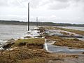
Damaged road at Chincoteague National Wildlife Refuge on Assateague Island
-
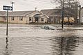
Flooding in Crisfield, Maryland
-
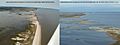
Before and after image of flooding caused by Hurricane Sandy at Prime Hook National Wildlife Refuge
-
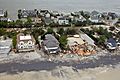
Damage to Mantoloking, New Jersey
-
Downed tree in Kutztown, Pennsylvania
-

Manhattan suffered a widespread power outage during the storm.
-

Suomi NPP satellite imagery showing the power outages in New York and New Jersey on November 1 compared to October 21.
-
Damage from Hurricane Sandy to a house in Brooklyn, New York.
-
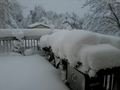
Snow from Hurricane Sandy in West Virginia
-

October 30, 2012, President Barack Obama visits the American Red Cross Digital Command Center following Hurricane Sandy
-
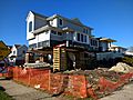
In Long Beach, New York, five years after the storm, homes were still being raised—lifted on temporary pilings so that permanent foundations could be put in.
-

A 2014 sign warned NYC commuters that the G train would shut down for repair due to 2012 Hurricane Sandy flooding. Several subway lines flooded by Hurricane Sandy would eventually require saltwater corrosion repair.


_(1).jpg)

.jpg)


_(8141816490).jpg)


See also
 In Spanish: Huracán Sandy para niños
