
Ontario facts for kids
Quick facts for kids
Ontario
|
|||
|---|---|---|---|
|
|||
| Motto(s): | |||
| Country | Canada | ||
| Confederation | July 1, 1867 (1st, with New Brunswick, Nova Scotia, Quebec) | ||
| Capital | Toronto | ||
| Largest city | Toronto | ||
| Largest metro | Greater Toronto Area | ||
| Government | |||
| • Type | Parliamentary constitutional monarchy | ||
| Area
(2021 land)
|
|||
| • Total | 1,076,395 km2 (415,598 sq mi) | ||
| • Land | 892,411.76 km2 (344,562.11 sq mi) | ||
| • Water | 158,654 km2 (61,257 sq mi) 14.7% | ||
| Area rank | Ranked 4th | ||
| 10.8% of Canada | |||
| Population
(2021)
|
|||
| • Total | 14,223,942 | ||
| • Estimate
(Q2 2024)
|
15,996,989 | ||
| • Rank | Ranked 1st | ||
| • Density | 15.94/km2 (41.3/sq mi) | ||
| Demonym(s) | Ontarian | ||
| Official languages | English | ||
| GDP | |||
| • Rank | 1st | ||
| • Total (2022) | CA$1,044.670 billion | ||
| • Per capita | CA$69,288 (8th) | ||
| HDI | |||
| • HDI (2021) | 0.943—Very high ([[List of Canadian provinces and territories by Human Development Index|3rd]]) | ||
| Time zones | |||
| East of 90th meridian west | UTC−05:00 (EST) | ||
| • Summer (DST) | UTC−04:00 (EDT) | ||
| West of 90th meridian west, except Atikokan and Pickle Lake | UTC−06:00 (CST) | ||
| • Summer (DST) | UTC−05:00 (CDT) | ||
| Atikokan and Pickle Lake (No DST) | UTC−05:00 (EST) | ||
| Postal abbr. |
ON
|
||
| Postal code prefix |
K L M N P
|
||
| ISO 3166 code | CA-ON | ||
| Flower | White trillium | ||
| Tree | Eastern white pine | ||
| Bird | Common loon | ||
| Rankings include all provinces and territories | |||


Ontario (![]() i/ɒnˈtɛərioʊ/ ON-tair-EE-oh) is Canada's southernmost province. It is located in Central Canada. Ontario is the province with the most people in the country. In 2021, about 38.5% of Canada's population lived here. It is also the second-largest province by total area, after Quebec.
i/ɒnˈtɛərioʊ/ ON-tair-EE-oh) is Canada's southernmost province. It is located in Central Canada. Ontario is the province with the most people in the country. In 2021, about 38.5% of Canada's population lived here. It is also the second-largest province by total area, after Quebec.
Ontario shares borders with Manitoba to the west and Quebec to the east. To the north, it touches Hudson Bay and James Bay. To the south, Ontario borders the U.S. states of Minnesota, Michigan, Ohio, Pennsylvania, and New York. Most of Ontario's border with the United States follows rivers and lakes, like the Great Lakes and the Saint Lawrence River.
Most of Ontario's people and farms are in Southern Ontario. Here, the economy relies a lot on making things (manufacturing). Northern Ontario has fewer people, very cold winters, and many forests. Its main industries are mining and forestry. Ontario is home to Canada's capital city, Ottawa, and its largest city, Toronto. Toronto is also the capital city of Ontario.
Contents
What Does "Ontario" Mean?
The name "Ontario" comes from Indigenous languages. It might come from the Huron word Ontarí:io, meaning "great lake." Or it could be from the Iroquoian languages word skanadario, meaning "beautiful water" or "sparkling water." Ontario has about 250,000 freshwater lakes! The name "Ontario" was first used in 1641 to describe the land north of the eastern Great Lakes. It became the official name of the province when Canada was formed in 1867.
Ontario's Geography

Over half of Ontario's land is covered by the Canadian Shield. This area is in the northwest and central parts of the province. It doesn't have much farmland but is rich in minerals. It also has many lakes and rivers. Northern Ontario is divided into two parts: Northwestern Ontario and Northeastern Ontario.
The far north and northeast have the Hudson Bay Lowlands. This area is mostly swampy with few trees and very few people.
Southern Ontario is divided into four smaller areas: Central Ontario, Eastern Ontario, the Golden Horseshoe, and Southwestern Ontario.
Even though Ontario doesn't have many mountains, it has large areas of high land. This is especially true in the Canadian Shield and along the Niagara Escarpment. The highest point is Ishpatina Ridge, which is 693 metres (2,274 feet) above sea level.
The Carolinian forest covers most of southwestern Ontario. The fertile Great Lakes-Saint Lawrence Valley in the south is now mostly farms, factories, and cities. A famous natural landmark is Niagara Falls. The Saint Lawrence Seaway allows ships to travel from the Atlantic Ocean all the way to Thunder Bay in Northwestern Ontario. Northern Ontario makes up about 87% of the province's land, but Southern Ontario has 94% of the people.
Point Pelee is the southernmost part of mainland Canada. It is a peninsula in Lake Erie, near Windsor.
Ontario's Climate

Ontario's weather changes with the seasons and where you are. Three main air types affect it:
- Cold, dry air from the Arctic (common in winter, especially in the far north).
- Air from the western Canadian Prairies.
- Warm, moist air from the Gulf of Mexico and the Atlantic Ocean.
Most of Ontario has a humid continental climate. This means it has warm summers and cold winters.
- The Great Lakes make the climate milder in southern Ontario. The lakes release heat in fall and winter, making winters less harsh near the shores. Southwestern Ontario and the Niagara region have warm, humid summers and cold winters. This area gets 750 to 1,000 mm (30 to 39 inches) of rain each year. Some areas get a lot of snow because of the lakes.
- Central and Eastern Ontario have warm summers and colder, longer winters with plenty of snow.
- In northeastern Ontario, the cold waters of Hudson Bay make summers cooler. Along the eastern shores of Lake Superior and Lake Huron, winters are a bit milder but get very heavy lake-effect snow. Some places get over 3 metres (10 feet) of snow!

- The northernmost parts of Ontario have a subarctic climate. This means very long, cold winters and short, cool summers. Temperatures can drop to -40°C (-40°F). Snow stays on the ground for more than half the year.
Thunderstorms are common in summer. Windsor gets the most lightning strikes in Canada. Ontario usually has about 11 tornadoes each year. Remnants of tropical storms sometimes bring heavy rains and winds to the south.
| City | July (°C) | July (°F) | January (°C) | January (°F) |
|---|---|---|---|---|
| Windsor (Windsor International Airport) | 28/18 | 82/64 | 0/−7 | 31/19 |
| Niagara Falls (NPCSH) | 27/17 | 81/63 | 0/−8 | 30/18 |
| Toronto (The Annex) | 27/18 | 80/64 | −1/−7 | 30/20 |
| Midland (Water Pollution Control Plant) | 26/16 | 78/61 | −4/–13 | 25/8 |
| Ottawa (Ottawa Macdonald–Cartier International Airport) | 27/16 | 80/60 | −6/−14 | 22/6 |
| Sudbury (Sudbury Airport) | 25/13 | 77/56 | −8/−19 | 18/0 |
| Emo (Emo Radbourne) | 25/11 | 77/52 | −9/–22 | 15/–9 |
| Thunder Bay (Thunder Bay International Airport) | 24/11 | 76/52 | −9/−21 | 18/−5 |
| Kenora (Kenora Airport) | 24/15 | 76/59 | −11/−21 | 12/−5 |
| Moosonee (UA) | 23/9 | 73/48 | −14/–26 | 8/–15 |
Ontario's History
Early Indigenous People (Before 1610)
The first people to live in Ontario were Paleo-Indians, about 11,000 years ago. They came from Asia across the Bering land bridge. During the Archaic period (8000-1000 BC), the population grew slowly. People were mostly hunter-gatherers. Trading routes started along the St. Lawrence River and around the Great Lakes.
Around 500 AD, people began growing corn, then beans and squash. This led to more permanent villages. By the 1400s, some villages in southern Ontario had thousands of people. They lived in longhouses that could hold over a hundred people. Around this time, large wars began in southern Ontario. This led to the rise of Iroquoian groups like the Neutral Confederacy, Erie, and Wendat (Huron). Groups in northern Ontario were mostly Algonquian, like the Ojibwe. They traded with the Iroquois.
Many Indigenous groups lived in Ontario, including the Algonquins, Mississaugas, Ojibway, Cree, Odawa, Pottowatomi, and Iroquois.
French Exploration and Settlement (1610–1763)
In the 15th century, Europeans looked for new sea routes to Asia. Giovanni da Verrazzano explored North America for France around 1522. This area was named "New France." Later, the demand for beaver fur brought French interest back.
In 1608, Samuel de Champlain started France's first settlement in New France, Quebec City. French explorers, like Étienne Brûlé in 1610, explored Southern Ontario. They called it the Pays d'en Haut ("Upper Country"). This area was upstream from the Saint Lawrence River. It was set up for defense and trade, not for many settlers. It included much of what is now Ontario and parts of several U.S. states. Indigenous peoples made up most of the population.

In 1611, English explorer Henry Hudson claimed the area around Hudson Bay for England. This became known as Rupert's Land.
French missionaries set up posts along the Great Lakes. The French made alliances with most Indigenous groups in Ontario. This was for the fur trade and to defend against Iroquois attacks. The Iroquois later allied with the British.
From 1634 to 1640, European diseases like smallpox greatly harmed the Huron people. By 1700, the Iroquois had left the area that would become Ontario. The Mississaugas of the Ojibwa settled the north shore of Lake Ontario.
During the French and Indian War (1754–1763), the British defeated France and its Indigenous allies. In 1763, France gave most of its North American lands to Britain. Britain then reorganized the territory into the Province of Quebec.
Province of Quebec (1763–1791)

After the American Revolution, about 5,000 United Empire Loyalists moved to what is now Ontario (1782–1784). Britain gave them land and supplies. The British also set up reserves for the Mohawks and other Iroquois who had fought for them. These groups had lost their land in New York state.
The first reserves for First Nations were created in 1784 at Six Nations and in 1793 at Tyendinaga. Akwesasne was an existing Mohawk community whose borders were set in 1795.
In 1788, southern Ontario was divided into four districts. In 1792, these districts were renamed. The population west of the St. Lawrence-Ottawa River grew a lot. Because of this, the Constitutional Act 1791 split Quebec into Upper Canada (southwest of the St. Lawrence-Ottawa River) and Lower Canada (east of it).
Upper Canada (1791–1841)

John Graves Simcoe became Upper Canada's first Lieutenant Governor in 1793. More Americans moved to Upper Canada after 1790, looking for cheap land and lower taxes.
By 1838, Upper Canada had twenty districts. During the War of 1812, American troops invaded Upper Canada. They were pushed back by the British, Canadians, and First Nations warriors. However, the Americans gained control of Lake Erie and Lake Ontario. In 1813, American troops defeated the garrison at York, the capital of Upper Canada. They looted the town and burned the Parliament Buildings. The British later burned Washington, D.C. in 1814.
.jpg)
After the War of 1812, more immigrants arrived from Europe, especially Britain and Ireland. Many found frontier life hard, but the population grew quickly. Society was mostly based on farming. New canals and roads helped trade within the colony and with the United States.
Ontario's many waterways helped people travel and transport goods. They also provided water power for development. As the population and industries grew, so did the transportation networks. By the end of the century, Ontario was a leader in Canada for population, industry, and communication.
People in the colony became unhappy with the powerful Family Compact who governed. This led to ideas of self-government. Rebellions for responsible government happened in both Upper and Lower Canada. William Lyon Mackenzie led the Upper Canada Rebellion, but it quickly failed.
Canada West (1841–1867)
Even though the rebellions failed, the British government sent Lord Durham to find out why. He suggested that the colonies should have responsible government. He also recommended joining Upper and Lower Canada to try and unite the French and English speakers. So, the two colonies became the Province of Canada in 1840. Upper Canada was renamed Canada West.

Responsible government was achieved in 1848. Many immigrants arrived in the 1840s. The population of Canada West more than doubled by 1851. For the first time, the English-speaking population of Canada West was larger than the French-speaking population of Canada East.
In 1849, the districts in southern Ontario were removed. County governments took over local duties. The Province of Canada also started creating districts in sparsely populated Northern Ontario.
The 1850s saw an economic boom and railway expansion. This made Central Canada economically stronger. Industries like timber, mining, and farming grew a lot.
By the 1850s, there was a political stalemate. There was also a fear of attack from the United States during and after the American Civil War. These factors led to the formation of the Great Coalition. This group worked to create a larger federal union of all British North American colonies. The British North America Act took effect on July 1, 1867. This created the Dominion of Canada with four provinces: Nova Scotia, New Brunswick, Quebec, and Ontario. The Province of Canada was divided into Ontario and Quebec. This was so each language group could have its own province. Toronto officially became Ontario's provincial capital.
Canadian Province (1867–Present)

After becoming a province, Ontario grew in economic and legislative power. In 1872, Oliver Mowat became Premier of Ontario. He was premier until 1896. He fought for provincial rights, which meant provinces had more power than the federal government. He helped expand Ontario's education and provincial institutions. He also created districts in Northern Ontario. He worked to make sure that parts of Northwestern Ontario became part of the province. This victory was confirmed in the Canada (Ontario Boundary) Act, 1889. Mowat also oversaw Ontario becoming a major economic force in Canada.
With the building of the Canadian Pacific Railway through Northern Ontario, Ontario's manufacturing and industry grew. However, population growth slowed after a recession in 1893. Many new immigrants moved west along the railway to other provinces.
The borders of northern and western Ontario were debated after Canada was formed. Ontario's right to Northwestern Ontario was confirmed in 1884. By 1899, there were seven northern districts. Four more were created between 1907 and 1912.
Mineral mining grew quickly in the late 1800s. This led to important mining towns like Sudbury and Timmins. The province used its water power to create hydroelectricity. This led to the creation of Ontario Hydro. Cheap electricity helped industries grow even more. The Ford Motor Company of Canada started in 1904. The McLaughlin Motor Car Company (later General Motors Canada) started in 1907. The car industry became very important to Ontario's economy in the 20th century.
In July 1912, the government limited French-language schooling for the province's French-speaking people. This caused outrage. The rule was eventually removed in 1927.

After World War II, Ontario experienced great growth and wealth. Most immigrants to Canada came to Ontario. Many came from Europe in the 1950s and 1960s. Since the 1970s, many non-European immigrants have arrived. Ontario has become very culturally diverse.
The movement for Quebec independence led many businesses and English-speaking people to move from Quebec to Ontario. As a result, Toronto became Canada's largest city and economic centre. Economic problems in the Maritime Provinces also led many people to move to Ontario.
Ontario's official language is English. However, there are many French-speaking communities. French-language services are available in areas with many French speakers, thanks to the French Language Services Act of 1989.
Ontario's People

| Historical populations | ||
|---|---|---|
| Year | Pop. | ±% |
| 1851 | 952,004 | — |
| 1861 | 1,396,091 | +46.6% |
| 1871 | 1,620,851 | +16.1% |
| 1881 | 1,926,922 | +18.9% |
| 1891 | 2,114,321 | +9.7% |
| 1901 | 2,182,947 | +3.2% |
| 1911 | 2,527,292 | +15.8% |
| 1921 | 2,933,662 | +16.1% |
| 1931 | 3,431,683 | +17.0% |
| 1941 | 3,787,655 | +10.4% |
| 1951 | 4,597,542 | +21.4% |
| 1956 | 5,404,933 | +17.6% |
| 1961 | 6,236,092 | +15.4% |
| 1966 | 6,960,870 | +11.6% |
| 1971 | 7,703,105 | +10.7% |
| 1976 | 8,264,465 | +7.3% |
| 1981 | 8,625,107 | +4.4% |
| 1986 | 9,101,695 | +5.5% |
| 1991 | 10,084,885 | +10.8% |
| 1996 | 10,753,573 | +6.6% |
| 2001 | 11,410,046 | +6.1% |
| 2006 | 12,160,282 | +6.6% |
| 2011 | 12,851,821 | +5.7% |
| 2016 | 13,448,494 | +4.6% |
| 2021 | 14,223,942 | +5.8% |
| Source: Statistics Canada | ||
Population
In 2021, Ontario had 14,223,942 people. This was a 5.8% increase from 2016. The province has a land area of 892,411.76 square kilometres (344,562.17 sq mi). This means it had about 15.9 people per square kilometre (41.2/sq mi) in 2021. The largest cities in Ontario are Toronto, Ottawa, Hamilton, Kitchener, London, and Oshawa. All of these cities have over 300,000 people.
Ethnic Backgrounds
Most Ontarians have English or other European roots. This includes large Scottish, Irish, and Italian communities. About 5% of Ontario's people speak French as their first language. However, about 11% of the population has French ancestors.
Immigration is a big reason for population growth in Ontario. This has been true for the last 200 years. More recent immigrants come from East Asia, South Asia, the Caribbean, Latin America, Europe, and Africa. Most of these groups have settled in the larger cities.
Visible Minorities and Indigenous Peoples
In 2021, 34.3% of the population were from visible minorities. Also, 2.9% of the population were Indigenous. Most Indigenous people are from First Nations and Métis groups. There are also a small number of Inuit in the province. The number of Indigenous people and visible minorities is growing faster than the general population in Ontario.
| Visible minority and Indigenous population (Canada 2021 Census) | |||
|---|---|---|---|
| Population group | Population | % | |
| European | 8,807,805 | 62.8% | |
| Visible minority group | South Asian | 1,515,295 | 10.8% |
| Chinese | 820,245 | 5.8% | |
| Black | 768,740 | 5.5% | |
| Filipino | 363,650 | 2.6% | |
| Arab | 284,215 | 2.0% | |
| Latin American | 249,190 | 1.8% | |
| Southeast Asian | 167,845 | 1.2% | |
| West Asian | 212,185 | 1.5% | |
| Korean | 99,425 | 0.7% | |
| Japanese | 31,420 | 0.2% | |
| Visible minority, n.i.e. | 124,120 | 0.9% | |
| Multiple visible minorities | 181,025 | 1.3% | |
| Total visible minority population | 4,817,360 | 34.3% | |
| Indigenous group | First Nations (North American Indian) | 251,030 | 1.8% |
| Métis | 134,615 | 1.0% | |
| Inuk (Inuit) | 4,310 | 0.0% | |
| Multiple Indigenous responses | 7,115 | 0.1% | |
| Indigenous responses n.i.e. | 9,515 | 0.1% | |
| Total Indigenous population | 406,585 | 2.9% | |
| 'Total population' | '14,031,750' | '100.0%' | |
Religions in Ontario
In 2021, 52.1% of the population was Christian. The largest Christian groups were Roman Catholics (26.0%) and the United Church of Canada (4.1%). Other religions included Islam (6.7%) and Hinduism (4.1%). About 31.6% of Ontarians said they had no religious affiliation.
The main religious groups in Ontario in 2021 were:
| Religion | People | % |
|---|---|---|
| Total | 14,031,750 | 100 |
| No religious affiliation | 4,433,675 | 31.6 |
| Catholic | 3,654,825 | 26.0 |
| Protestant | 2,187,685 | 15.6 |
| Other Christians | 1,143,450 | 8.15 |
| Muslim | 942,990 | 6.7 |
| Hindu | 573,700 | 4.1 |
| Christian Orthodox | 329,850 | 2.35 |
| Sikh | 300,435 | 2.1 |
| Jewish | 196,100 | 1.4 |
| Buddhist | 164,215 | 1.2 |
| Other religions | 104,830 | 0.7 |
Languages Spoken in Ontario


English is the main language in Ontario. About 97.2% of Ontarians can speak English. However, only 69.5% reported English as their first language in 2016. English and French are the official languages in Ontario's courts.
About 4.6% of the population speaks French as their first language. A total of 11.5% of Ontarians can speak French. About 11.2% of Ontarians can speak both English and French.
Franco-Ontarians are French-speaking people living in Ontario. They are mostly found in the northeastern, eastern, and far southern parts of the province. In these areas, provincial government services must be available in French. This happens if at least 10% of the population speaks French as their native language. Or if a city has at least 5,000 French speakers.
Many other languages are spoken in Ontario. These include Arabic, Mandarin, Hindi, Spanish, Punjabi, Cantonese, Italian, and Urdu.
Ontario's Economy
Ontario is Canada's top manufacturing province. In 2004, it made 52% of all manufactured goods in the country. Ontario's biggest trading partner is the U.S. state of Michigan.
Mining and forest products (like pulp and paper) are very important to Northern Ontario's economy.

Ontario has many natural resources. It also has great transportation links to North America. The Great Lakes allow ships to reach the ocean. These things have made manufacturing the main industry in the province. This industry is mostly in the Golden Horseshoe region. Important products include cars, iron, steel, food, and chemicals.
Hamilton is Canada's largest steel manufacturing city. Sault Ste. Marie is also a major steel producer. Sarnia is a centre for petrochemical production.
Ontario makes more cars than Michigan. In 2004, it assembled over 2,696,000 vehicles. Many major car companies have plants in Ontario. These include Chrysler, GM, Honda, Ford, and Toyota. However, the province has lost many manufacturing jobs since 2003.

Toronto, Ontario's capital, is the centre of Canada's financial services and banking industry. Nearby cities have product distribution, IT centres, and manufacturing. Canada's federal government is the largest employer in the National Capital Region. This area includes Ottawa in Ontario and Gatineau in Quebec.
The information technology (IT) sector is important. Especially in the "Silicon Valley North" area of Ottawa. This is Canada's largest technology park. IT is also important in the Waterloo Region, where BlackBerry is located.
Tourism is a big part of Central Ontario's economy. It is busiest in summer because of the many lakes and wilderness areas. In other seasons, hunting, skiing, and snowmobiling are popular. The fall colours are beautiful, and tours are organized for visitors. Tourism is also important in border cities with large casinos, like Windsor and Niagara Falls.
Farming in Ontario
.jpg)
Farming used to be the biggest industry. Now, it employs a smaller percentage of workers. Even though there are fewer farms, they produce more food due to better machines. This helps feed the growing population.
| Ontario Farming | 1986 | 1991 | 1996 | 2001 | 2006 | |
|---|---|---|---|---|---|---|
| Number of Farms | 72,713 | 68,633 | 67,520 | 59,728 | 57,211 | |
| Total | Hectares | 5,646,582 | 5,451,379 | 5,616,860 | 5,466,233 | 5,386,453 |
| Acres | 13,953,009 | 13,470,652 | 13,879,565 | 13,507,358 | 13,310,217 | |
| Planted Crops |
Hectares | 3,457,966 | 3,411,667 | 3,544,927 | 3,656,705 | 3,660,941 |
| Acres | 8,544,821 | 8,430,438 | 8,759,707 | 9,035,916 | 9,046,383 | |
| Source: Statistics Canada, Census of Agriculture. |
|
|||||
.jpg)
Common farms grow cattle, grains, and dairy products. The fruit and wine industry is mainly in the Niagara Peninsula and along Lake Erie. Tobacco farms are also there. Vegetables grow well in the rich soils of the Holland Marsh near Newmarket. The area near Windsor is also very fertile.
The "Corn Belt" covers much of southwestern Ontario. However, corn and soy are grown throughout the southern part of the province. Apple orchards are common near Collingwood and along Lake Ontario. Tobacco farming has decreased, making way for other crops like hazelnuts and ginseng.
Southern Ontario is losing farmland quickly due to urban growth. To protect farmland and green spaces, the governments created greenbelts around Ottawa and the Golden Horseshoe. These areas limit urban development.
Energy in Ontario
Ontario's rivers provide a lot of hydroelectric energy. In 2009, Ontario Power Generation made 70% of the province's electricity. Of this, 51% came from nuclear plants, 39% from hydroelectric plants, and 10% from fossil-fuels.

Even with many power options, Ontario sometimes buys power from Quebec and Michigan. This happens during times of high energy use.
The Green Energy and Green Economy Act, passed in 2009, aims to bring more renewable energy sources to Ontario. It also promotes energy-efficiency. This law helps projects that use renewable energy. It also offers help to homeowners who want to install small-scale renewable energy systems like solar panels.

Niagara Falls provides a lot of electricity to Ontario. The Bruce Nuclear Generating Station is also in Ontario. It is the second largest working nuclear power plant in the world. It uses 8 reactors to make electricity.
Ontario has the most wind energy capacity in Canada. It has 4,900 MW of power, which is 41% of Canada's total.
Education in Ontario
Ontario has four publicly funded school systems: English public, French public, English Catholic, and French Catholic. About half of Ontario's school boards are Catholic. A few publicly funded schools have other religious affiliations. The Education Act sets the rules for schools in Ontario. In 2021, two million children were students in the province.
Elementary schools teach children from kindergarten to grade 8. Secondary schools teach students in grades 9 to 12. Children can start kindergarten at age four or five, but they must be in school by age six.
Higher Education
Higher education in Ontario includes colleges and universities. The Ministry of Colleges and Universities oversees these schools. Universities focus more on academics, while colleges focus more on hands-on learning. Both can offer undergraduate degree programs. Some programs even involve both a college and a university. Many students choose college because it can be more affordable.
Ontario's Culture
Outdoor activities are popular in Ontario. The province also hosts many cultural events and festivals. There isn't one specific dish for Ontario. However, local fish and wild game like walleye and moose are sometimes eaten. Poutine, a dish from Quebec, is also popular.
In 2019, Ontario created the position of Poet Laureate of Ontario.
Museums in Ontario

The largest museum in Ontario and Canada is the Royal Ontario Museum. It is in Toronto and was founded in 1912. Over one million people visit it each year, making it Canada's most popular museum. It has 40 exhibits about "art, culture and nature from around the world." Famous items include the world's largest faceted cerussite gem, four large totem poles, and a Neo-Babylonian wall relief.
Ontario is also home to several national museums because Ottawa is the capital. These include the Canadian War Museum, the Canadian Museum of Nature, and the Canada Science and Technology Museum. There are also many smaller, local museums across Ontario.
Music and Arts

Ontario plays a big role in Canadian music. Toronto, the provincial capital, is Canada's largest city. In classical music, the Toronto Symphony Orchestra and the National Arts Centre Orchestra are famous worldwide. Many smaller Ontario cities also have their own orchestras. The Canadian Opera Company, also in Toronto, is Canada's largest opera producer. Other important places include the Royal Conservatory of Music and concert venues like Roy Thomson Hall.
Media
As of 2022, Ontario has 357 newspapers, with 32 being daily. This is the most in any province. Ontario is home to Canada's largest newspaper, the Toronto Star, and Canada's newspaper of record, The Globe and Mail. There are also many weekly newspapers for local communities.
Songs and Slogans

In 1973, the first slogan on Ontario licence plates was "Keep It Beautiful." This changed to "Yours to Discover" in 1982. Plates with the French version, Tant à découvrir, became available in 2008. In 2020, the slogan briefly changed to "A Place to Grow" but was changed back to "Yours to Discover" due to visibility issues.
"A Place to Stand, a Place to Grow" is a song made for Ontario's pavilion at Expo 67. It is an unofficial anthem of the province.
Professional Sports
Ontario has professional sports teams in many sports. These include baseball, basketball, Canadian football, ice hockey, lacrosse, rugby league, rugby union, and soccer.
| Club | Sport | League | City | Stadium |
|---|---|---|---|---|
| Atlético Ottawa | Soccer | CPL | Ottawa | TD Place Stadium |
| Belleville Senators | Ice hockey | AHL | Belleville | CAA Arena |
| Forge FC | Soccer | CPL | Hamilton | Tim Hortons Field |
| Guelph Nighthawks | Basketball | CEBL | Guelph | Sleeman Centre |
| Hamilton Honey Badgers | Basketball | CEBL | Hamilton | FirstOntario Centre |
| Hamilton Tiger-Cats | Football | CFL | Hamilton | Tim Hortons Field |
| KW Titans | Basketball | NBLC | Kitchener | Kitchener Memorial Auditorium |
| London Lightning | Basketball | NBLC | London | Budweiser Gardens |
| Niagara River Lions | Basketball | CEBL | St. Catharines | Meridian Centre |
| Ottawa Blackjacks | Basketball | CEBL | Ottawa | TD Place Arena |
| Ottawa Redblacks | Football | CFL | Ottawa | TD Place Stadium |
| Ottawa Senators | Ice hockey | NHL | Ottawa | Canadian Tire Centre |
| Ottawa Titans | Baseball | FL | Ottawa | Raymond Chabot Grant Thornton Park |
| PWHL Ottawa | Ice Hockey | PWHL | Ottawa | TD Place Arena |
| PWHL Toronto | Ice Hockey | PWHL | Toronto | Mattamy Athletic Centre |
| Raptors 905 | Basketball | G League | Mississauga | Paramount Fine Foods Centre |
| Sudbury Five | Basketball | NBLC | Greater Sudbury | Sudbury Community Arena |
| Toronto Argonauts | Football | CFL | Toronto | BMO Field |
| Toronto Arrows | Rugby union | MLR | Toronto | York Lions Stadium |
| Toronto Blue Jays | Baseball | MLB | Toronto | Rogers Centre |
| Toronto FC | Soccer | MLS | Toronto | BMO Field |
| Toronto FC II | Soccer | USL | Toronto | Lamport Stadium |
| Toronto Maple Leafs | Ice hockey | NHL | Toronto | Scotiabank Arena |
| Toronto Marlies | Ice hockey | AHL | Toronto | Coca-Cola Coliseum |
| Toronto Raptors | Basketball | NBA | Toronto | Scotiabank Arena |
| Toronto Rock | Lacrosse | NLL | Hamilton | FirstOntario Centre |
| Toronto Wolfpack | Rugby league | NARL | Toronto | Lamport Stadium |
| Windsor Express | Basketball | NBLC | Windsor | WFCU Centre |
| York United FC | Soccer | CPL | Toronto | York Lions Stadium |
Transportation in Ontario
The Ministry of Transportation of Ontario and Transport Canada manage transportation in Ontario. The Ministry of Transportation handles roads. Transport Canada handles air, rail, and water travel.
Air Travel

As of October 2023, Ontario has two major international airports.
- Toronto Pearson International Airport is Canada's busiest airport. It handled almost 35 million passengers in 2022.
- Ottawa Macdonald–Cartier International Airport is Ontario's second largest. It handled over 2.5 million passengers in 2022.
The province also has 11 other smaller airports that handle international flights.
Many Ontario cities have regional airports. These often have flights from smaller airlines to larger airports in Toronto and Ottawa. Bearskin Airlines flies along a northern route, connecting cities like North Bay and Thunder Bay.
Some remote towns in northern Ontario rely completely on air service. This is for travel, goods, and even ambulance services. Many areas in the far north cannot be reached by road or rail all year.
Railways

Via Rail offers passenger train service between cities in the Quebec City–Windsor Corridor. It also runs The Canadian, a train that goes across Canada from Southern Ontario to Vancouver. Amtrak connects Ontario to cities in New York. Ontario Northland provides train service to places as far north as Moosonee.
Regional commuter rail is provided by GO Transit. It serves the Golden Horseshoe region. Union Station in Toronto is a major transportation hub.
Freight trains are mainly run by Canadian National Railway and Canadian Pacific Kansas City. In 2021, Ontario had 19,979 km (12,414 miles) of railways.
Several cities have their own train systems. The Toronto Transit Commission operates subways and streetcars. OC Transpo operates a light rail system in Ottawa. The Waterloo region has a light rail system called Ion. New light rail lines are also being built in the Regional Municipality of Peel.

Roads

The 400-series highways are the main road network in southern Ontario. They connect to border crossings with the United States and Quebec. The busiest crossings are the Detroit–Windsor Tunnel and Ambassador Bridge. Some main highways are Highway 401, Highway 417, and Highway 400. Highway 401 is the busiest highway in North America. Other provincial highways connect the rest of the province. The Trans-Canada Highway connects Ontario to other parts of Canada.
Waterways
The Saint Lawrence Seaway is the main water route for cargo. It runs through southern Ontario and connects to the Atlantic Ocean. It is used for shipping things like iron ore and grain. In the past, the Great Lakes and St. Lawrence River were also used for passenger travel. However, passenger traffic has greatly decreased since the 1930s.
Ontario's three largest ports are the Port of Hamilton, Port of Thunder Bay, and the Port of Nanticoke. Ontario's only saltwater port is in Moosonee on James Bay.
Images for kids
-
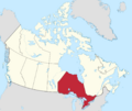
Map showing Ontario's location east/central of Canada.
-

A red flag with a large Union Jack in the upper left corner and a shield in the centre-right
-
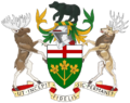
A central shield with the upper part showing the red cross of St. George and the lower part showing three golden maple leaves on a green background. There is a black bear on top of a knight's helmet above the shield with a moose to the left and a Canadian deer to the right. The province's motto "Ut incepit Fidelis sic permanent", Latin for "Loyal she began, loyal she remains" is written below the crest.
See also
 In Spanish: Ontario para niños
