
Trans-Canada Highway facts for kids
Quick facts for kids
|
|
|---|---|
| Route information | |
| Length | 7,476 km (4,645 mi)
Main route
|
| Existed | July 30, 1962–present |
| Major junctions | |
| From | Victoria and Haida Gwaii, British Columbia |
| To | St. John's, Newfoundland and Labrador |
| Location | |
| Major cities: | Victoria, Vancouver, Abbotsford, Kamloops, Calgary, Edmonton, Regina, Saskatoon, Winnipeg, Thunder Bay, Sault Ste. Marie, Greater Sudbury, North Bay, Orillia, Peterborough, Ottawa, Montréal, Drummondville, Quebec City, Edmundston, Fredericton, Moncton, Charlottetown, St. John's |
| Highway system | |

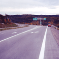
The Trans-Canada Highway (in French: Route Transcanadienne) is a huge highway system that crosses all ten provinces of Canada. It stretches from the Pacific Ocean on the west coast to the Atlantic Ocean on the east coast. The main road is about 7,476 km (4,645 mi) long, making it one of the longest highways in the world! You can easily spot it by its special white-on-green signs with a maple leaf.
Even though the Trans-Canada Highway is a whole system with a few different paths, people usually mean the main route when they talk about it. This main route includes different highway numbers in each province. For example, it's Highway 1 in Western Canada and parts of Ontario and Newfoundland. It also uses parts of Autoroutes in Quebec and other highways in the Maritimes. This main path starts in Victoria and ends in St. John's. It connects many big cities like Vancouver, Calgary, Winnipeg, Ottawa, and Montreal. One of the other routes even connects to Prince Edward Island, Canada's tenth province.
Other routes are part of the system but are often called by different names. For instance, Highway 16 in Western Canada is part of the Trans-Canada Highway system, but it's almost always called the Yellowhead Highway. Highway 1, however, is always known as the Trans-Canada Highway and carries much more traffic.
The Trans-Canada Highway system doesn't go into Canada's three northern territories or directly to the United States border. However, it is part of Canada's bigger National Highway System, which does connect to these areas.
Contents
How the Highway is Managed
.svg)

Canada's highways are mostly managed by each province, not the federal government. This means each province decides how to build and maintain its part of the Trans-Canada Highway. They also choose the highway numbers.
In Western Canada, the main Trans-Canada route is called Highway 1, and the Yellowhead route is Highway 16. Prince Edward Island and Newfoundland also use Highway 1 for their sections. New Brunswick uses Highway 2. East of Manitoba, the highway numbers often change when you cross into a new province. In Ontario and Quebec, you'll see the regular provincial highway signs along with the special maple leaf Trans-Canada Highway signs. Because the Trans-Canada Highway was made up of existing roads, it's unlikely it will ever have the same number all the way across the country.
Highway Design and Quality
The Trans-Canada Highway doesn't have one single design standard across the country. When it was first built, most of it was a two-lane road, not a big multi-lane freeway. This means the quality of the highway can change a lot from one province or city to another.
In many parts of British Columbia, Ontario, Prince Edward Island, and Newfoundland, the highway is still a two-lane road. British Columbia is working to make its Highway 1 section east of Kamloops into a four-lane divided highway. Alberta, Saskatchewan, and Manitoba have already made most of their southern Trans-Canada Highway sections four lanes wide. In Quebec, most of the Trans-Canada Highway uses the province's Autoroute freeways. New Brunswick is the only province where its entire main Trans-Canada Highway route is a four-lane freeway.
Many parts of the Trans-Canada Highway that are not freeways go right through towns. This means homes and businesses are often right next to the highway, making it feel like a main street.
Sometimes, the Trans-Canada Highway isn't the fastest way to get between two cities. For example, many drivers between Hope and Kamloops use the Coquihalla Highway instead, because it's shorter. Also, some people driving long distances between Western and Eastern Canada might even drive through the United States to use their Interstate Highway System, rather than the Trans-Canada Highway through Northern Ontario.
Main Route Details
British Columbia


In British Columbia, the main Trans-Canada Highway is called Highway 1. It's 1,045 km (649 mi) long. It starts in Victoria where a "Mile 0" plaque marks the beginning. The highway goes north along Vancouver Island to Nanaimo. From there, you take a BC Ferries boat across the water to Horseshoe Bay.
After the ferry, the highway becomes a four-to-eight-lane freeway through Metro Vancouver. It then continues as a four-lane freeway east through the Fraser Valley to Hope. From Hope, the Trans-Canada Highway turns north through Fraser Canyon and Thompson Canyon to Cache Creek. This part is mostly a two-lane road and is very scenic. The faster freeway route is Highway 5. Near Kamloops, Highway 1 becomes a freeway again for a short time, then a four-lane road through the city. East of Kamloops, it's mostly a two-lane road through the mountains, with some wider sections in towns like Salmon Arm and Revelstoke.
The highway crosses two high mountain passes: Rogers Pass in Glacier National Park and Kicking Horse Pass in Yoho National Park. Kicking Horse Pass is the highest point on the entire Trans-Canada Highway, at 1,627 m (5,338 ft).
Speed limits on the mainland part of the highway in British Columbia are usually 90–100 km/h (56–62 mph). In towns, it can be as low as 50 km/h (31 mph). On Vancouver Island, speeds are lower due to the challenging land and many towns.
Alberta, Saskatchewan and Manitoba

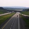
The Trans-Canada Highway through Alberta, Saskatchewan, and Manitoba is 1,667 km (1,036 mi) long. It starts at the British Columbia border and goes all the way to the Ontario border. In Alberta, it's Highway 1 and goes through Banff National Park, passing by Lake Louise, Banff, and Canmore before reaching Calgary. This part of the highway is very popular with tourists. It was also one of the first highways in North America to have special bridges and fences for wildlife to cross safely.
In Calgary, the highway becomes a busy six-lane street called 16 Avenue N. After Calgary, it continues as a four-lane expressway for 293 km (182 mi) with few stops. It passes Medicine Hat and then crosses into Saskatchewan. The highway is mostly a straight, four-lane road through these areas. It goes around Regina on the Regina Bypass, which was a very expensive project. Beyond Regina, it continues east into Manitoba, passing Brandon and Portage la Prairie, and finally reaching Winnipeg. The southern part of Winnipeg's Perimeter Highway (Highway 100) is part of the Trans-Canada Highway system and goes around the city.
Almost the entire length of Highway 1 through the Prairie Provinces is a four-lane highway. While only some parts are true freeways, most of the highway has no traffic lights.
The speed limit is 90 km/h (56 mph) in national parks like Banff. East of Banff, most of Highway 1 in Alberta, Saskatchewan, and Manitoba has a speed limit of 110 km/h (68 mph), but it's 100 km/h (62 mph) east of Winnipeg.
Ontario


East of Winnipeg, the highway continues for over 200 km (120 mi) to Kenora, Ontario. At the border, the highway changes from Highway 1 to Highway 17. It has both the provincial sign and the maple leaf Trans-Canada sign. This section goes through the Canadian Shield, a rugged area with many forests and lakes.
Highway 11/Highway 17 then goes southeast to Thunder Bay, then northeast to Nipigon. A 83-kilometre (52 mi) part of the highway between Thunder Bay and Nipigon is called the Terry Fox Courage Highway. This is where Terry Fox had to stop his incredible cross-country run, and a bronze statue was built to honor him. This highway is the only road connecting eastern and western Canada. In 2016, the Nipigon River Bridge broke, closing the highway for 17 hours. The only other way around was through the United States.
Highway 17 continues east from Nipigon along the northern and eastern coast of Lake Superior. Between Wawa and Sault Ste. Marie, the highway crosses the Montreal River Hill, which can be difficult in winter due to steep slopes. At Sault Ste. Marie, the main route turns east to Sudbury.
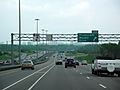
The highway then continues east from Sudbury to North Bay. From North Bay, it goes to Arnprior, where it becomes a freeway called Highway 417. This freeway continues to Ottawa, passing through the city with six to eight lanes. In Southern Ontario, the speed limit is usually 80 km/h (50 mph), while in Northern Ontario it's 90 km/h (56 mph). Parts of Highway 417 outside Ottawa have a higher limit of 110 km/h (68 mph).
While Highways 17 and 417 are mostly free of traffic jams, the non-freeway parts can close often due to crashes, especially in winter. It's considered a dangerous route because many sections are winding two-lane roads. Collisions with animals are also common here.
The Trans-Canada Highway mostly avoids Canada's most populated area, the Golden Horseshoe near Toronto. You can get to Toronto from the highway using other major roads like Highway 400 or Highway 401.
Quebec

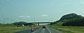
From Ottawa, the Trans-Canada Highway continues as a freeway for 206 km (128 mi) east to Montreal. In Quebec, it's called Autoroute 40. As it goes through Montreal, it's known as Autoroute Métropolitaine, which is an elevated freeway. The highway then follows Autoroute 25 south, crossing the St. Lawrence River through the Louis-Hippolyte Lafontaine Bridge–Tunnel. It then goes northeast on Autoroute 20 for 257 km (160 mi) to Lévis (across from Quebec City).
East of Lévis, the Trans-Canada Highway continues on Autoroute 20 along the south bank of the St. Lawrence River. It then turns southeast and becomes Autoroute 85 for 43 km (27 mi). After that, it changes to Route 185, which is not a freeway, for 9 km (5.6 mi) until Saint-Louis-du-Ha! Ha!, where Autoroute 85 starts again. The total distance from Autoroute 20 to Edmundston, New Brunswick, is about 120 km (75 mi).
Since most of the Trans-Canada Highway in Quebec uses the province's Autoroute system, which is always at least a four-lane freeway, travel through Quebec is usually safe, fast, and without much traffic. The main exception is the route through Montreal, which can get busy. However, drivers can use the tolled Autoroute 30 to go around the city.
The speed limit on Quebec's Autoroutes (including the Trans-Canada Highway) is strictly 100 km/h (62 mph). It might be lower in certain places like tunnels.
Quebec has been working to upgrade the 40-kilometre-long (25 mi) two-lane section of Trans-Canada Highway along Route 185 to a freeway. This project is expected to be finished by 2026. Once it's done, all of Quebec's main Trans-Canada Highway route will be a four-lane freeway. This will also make the Trans-Canada Highway a continuous freeway from Arnprior, Ontario, to Lower South River, Nova Scotia.
New Brunswick
The Trans-Canada Highway enters New Brunswick and becomes Route 2 near Edmundston. From Edmundston, the highway follows the Saint John River Valley south to Woodstock, then east to Fredericton. It continues east to Moncton.
New Brunswick finished a 20-year project on November 1, 2007, to make its entire 516 km (321 mi) section of the Trans-Canada Highway into a four-lane, divided highway with limited access. This means it was the first province to have its main Trans-Canada Highway route entirely as a four-lane freeway. The speed limit is 110 km/h (68 mph) on most parts of the highway in New Brunswick.
From Moncton, the highway goes southeast to Aulac near the New Brunswick–Nova Scotia border. Here, the Trans-Canada Highway splits. The main route continues to Nova Scotia as Route 2, and another 70-kilometre (43 mi) route, Route 16, goes east to the Confederation Bridge at Cape Jourimain.
Nova Scotia

From the New Brunswick border, the main Trans-Canada Highway route continues east into Nova Scotia as Highway 104, passing Amherst. Near Thomson Station, the highway goes through the Cobequid Pass, which is a 45-kilometre (28 mi) tolled section. It then passes Truro, where it connects with Highway 102 to Halifax. Halifax, like Toronto, is a provincial capital that the Trans-Canada Highway doesn't go through directly.
Beyond Truro, the highway continues east to New Glasgow, where it meets Highway 106. It then goes to the Canso Causeway, which crosses the Strait of Canso onto Cape Breton Island. From the Canso Causeway, the highway continues east as Highway 105 on Cape Breton Island, until it reaches the Marine Atlantic ferry terminal at North Sydney.
Newfoundland and Labrador

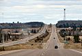
From North Sydney, a 177-kilometre (110 mi) ferry ride, run by Marine Atlantic, continues the highway to Newfoundland. It arrives at Channel-Port aux Basques, where the Trans-Canada Highway becomes Highway 1. The highway goes northeast for 219 km (136 mi) through Corner Brook, and then east for another 352 km (219 mi) through Gander. It then travels southeast and northeast, finally ending in St. John's.
The total length of the highway across Newfoundland is 905 km (562 mi). The eastern end of the highway is at an intersection with Outer Bay Road/White Hills Road and Logy Bay Road. Most of the Trans-Canada Highway in Newfoundland is undivided, but some parts in cities like Corner Brook and St. John's are divided.
"Mile Zero" Markers
.jpg)

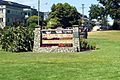
There isn't one official "starting point" for the entire Trans-Canada Highway. However, St. John's has adopted this name for its section of the highway. The foot of East White Hills Road in St. John's is considered a precise starting point.
The other end of the Trans-Canada Highway in Victoria, at the foot of Douglas Street and Dallas Road, also has a "mile zero" monument. St. John's downtown arena, Mary Brown's Centre, was even named "Mile One Centre" because of its location near the highway's start.
The use of "miles" instead of "kilometres" for these markers goes back to when the Trans-Canada Highway was finished in 1962, before Canada switched to the metric system.
Other Important Routes
Yellowhead Highway (Highway 16)
The Yellowhead Highway is a 2,859-kilometre (1,777 mi) highway in Western Canada. It runs from Masset, British Columbia, to just west of Portage la Prairie, Manitoba, where it meets Highway 1. It's called Highway 16 in all four provinces it crosses (British Columbia, Alberta, Saskatchewan, and Manitoba). It goes through a more northern part of Western Canada than the main Trans-Canada Highway and passes through fewer cities, with Edmonton being the largest. Other big towns on this route include Prince Rupert and Saskatoon.
The Yellowhead Highway is famous for going through Jasper National Park in Alberta, where it crosses the Continental Divide at Yellowhead Pass. Because it has less traffic than the main Trans-Canada Highway, the Yellowhead is mostly a two-lane road in British Columbia and Manitoba. It's only partly a four-lane expressway in Alberta and Saskatchewan.
Northern Ontario & Quebec Routes
A 1,547-kilometre (961 mi) section of Highway 71 and Highway 11 between Kenora and North Bay, Ontario, is also part of the Trans-Canada Highway. This route goes south of the main Trans-Canada Highway between Kenora and Thunder Bay, passing through Fort Frances near the U.S. border. After joining the main route for a bit, Highway 11 splits off north at Nipigon, going through a vast, less populated area of northern Ontario. This highway doesn't see as much long-distance traffic as the main route.
A shorter 60-kilometre (37 mi) section of Highway 66 connects another northern Trans-Canada Highway route to Quebec's Highway 117. This highway then continues the Trans-Canada route to Montreal after connecting with Autoroute 15. Most of these northern highways are two-lane roads.
Central Ontario / Georgian Bay Route
The southern Ontario Trans-Canada Highway route is a bit more complicated. It uses four different provincial highways and isn't really a major long-distance route because it goes around the Toronto area. It's a 671-kilometre-long (417 mi) alternate route to Highway 17 (the main Trans-Canada Highway) between Sudbury and Ottawa. It passes through towns like Orillia and Peterborough. Because it's closer to bigger towns, this part of the Trans-Canada Highway has more traffic. It includes different types of roads, from freeways to two-lane routes.
Prince Edward Island Route
Another branch of the Trans-Canada Highway splits off the main route in eastern New Brunswick. This route connects to Prince Edward Island using the 13-kilometre-long (8.1 mi) Confederation Bridge. It crosses the middle of Prince Edward Island, including through the capital city of Charlottetown, before going back to the mainland on a ferry. This route is 234 km (145 mi) long and includes New Brunswick Highway 16, Prince Edward Island Highway 1, and Nova Scotia Highway 106. This part of the Trans-Canada Highway is quite busy and is important for tourists. The Confederation Bridge itself is a popular sight. While mostly a two-lane road, parts of this route are built as two-lane expressways.
Bypass Routes
Two shorter bypasses are also part of the Trans-Canada Highway system. These are the 42-kilometre-long (26 mi) Perimeter Highway 100 around Winnipeg, which is a faster way to avoid the busy city center. The other is the 34-kilometre-long (21 mi) two-lane Kenora Bypass (Highway 17A), which goes around the town of Kenora to the north.
History of the Highway
Earlier Roads
Long before the Trans-Canada Highway, many of its paths were first explored to build the Canadian Pacific Railway in the late 1800s.
The Trans-Canada Highway wasn't the very first road across Canada. In British Columbia, there were older highways like the Crowsnest Highway and the Cariboo Highway, built during the Great Depression. Many of these early roads were gravel and needed ferries to cross wide rivers. In Alberta, a road between Calgary and Banff existed in the 1910s. A gravel road across northern Ontario (Highway 17) started being built in 1931 and was mostly open by the late 1930s. Even with gaps, people could still cross the country by using trains or boats to get around unfinished sections.
When it Opened
The plan for the highway system was approved by the Trans-Canada Highway Act in 1949, and construction began in 1950. The highway officially opened in 1962. This happened when the Rogers Pass section between Golden and Revelstoke was finished. This new section replaced the old Big Bend Highway, which was the last gravel part of the route. When it first opened, the Trans-Canada Highway was the longest continuous highway in the world. Construction on other parts continued until 1971, when the last gap on Highway 16 was completed.
Changes from 1960 to 2000
When the Trans-Canada Highway first opened, it was almost entirely a two-lane road. While it was a big improvement, it soon became clear it wasn't enough for the growing number of cars. So, provinces started building new sections, widening roads, and adding freeways to handle more traffic and improve safety.
In British Columbia, new freeway sections were opened in the Vancouver area in the 1960s to help traffic move better. The Cassiar Tunnel opened in 1990, removing the last traffic lights in Vancouver on the Trans-Canada Highway. After the Coquihalla Highway opened in 1986, the Trans-Canada Highway through the Fraser Canyon became less busy. This new freeway made the drive between Hope and Kamloops 90 minutes shorter. While this was good for drivers, it caused problems for many towns along the old Fraser Canyon route, as tourism and business decreased.
In Alberta, between 1964 and 1972, the Trans-Canada Highway was completely changed between Banff and Calgary. It became a new, more direct four-lane freeway. This meant it bypassed several towns. From 1973 to 1990, the highway was made into a divided road from Calgary to the Saskatchewan border.
Between Ottawa and the Ontario–Quebec border, the Trans-Canada Highway name was moved from the two-lane Highway 17 to the existing Highway 417 freeway in 1997–98. This meant that parts of Highway 17 within Ottawa were handed over to the city and county to manage. In 1990, the two-lane Kenora Bypass opened, helping traffic avoid the busy town.
Starting in the 1960s, Quebec began building its Autoroute network. Many parts of the Trans-Canada Highway were widened to freeway standards during this time.
In 1987, New Brunswick started widening its section of the Trans-Canada Highway to four lanes. The work to make it a full freeway began in the late 1990s and was finished in 2007.
The 13-kilometre-long (8.1 mi) Confederation Bridge connecting PEI to New Brunswick opened in 1997. It replaced the ferry that used to run there and was seen as a major achievement.
Recent Changes (2000–Present)
In the early 2000s, the Canadian government thought about funding a project to make the entire Trans-Canada Highway system into divided highways with limited access. While some funding was given, a full conversion didn't happen because some parts of the highway didn't have enough traffic to justify it.
Before 2008, the highway in the Rocky Mountains from Banff National Park to Golden, British Columbia, saw some big changes. A major part of this project was finished in 2007, opening 16 km (9.9 mi) of new four-lane highway. Other smaller widening projects also happened in British Columbia. In Metro Vancouver, 37 km (23 mi) of busy four-lane Highway 1 freeway were widened to eight lanes starting in 2012. This project is still ongoing, with the goal of making the freeway at least six lanes wide from Langley to Abbotsford by 2025.
The widening of the highway in Alberta's Banff National Park continued, with four-lane highway reaching the Highway 93 junction north of Lake Louise by winter 2010. Parks Canada finished widening the last 8.5 km (5.3 mi) of Highway 1 between Lake Louise and the British Columbia border, opening it on June 12, 2014. This made the entire main Trans-Canada Highway route in Alberta at least four lanes wide. Stoney Trail began construction in 2005 and could be used as a bypass around Calgary when its northeastern section opened in 2010.
During the 2000s, much of the Trans-Canada Highway through Saskatchewan and Manitoba was twinned (made into a divided highway). In 2019, the Regina Bypass opened, moving the Trans-Canada Highway around the city and avoiding a busy section with many traffic lights.
The 2010s also saw changes to other Trans-Canada Highway routes. Ontario Highway 400 began to be extended towards Sudbury, replacing Highway 69 and creating a freeway section for part of the Southern Ontario Trans-Canada Highway Route. This project is still continuing.
Edmonton is working to widen its urban section of Highway 16 to a six-lane freeway. Most of Highway 16 in Alberta was twinned during the 2000s.
Even with all these widenings, over half of the main Trans-Canada Highway is still a two-lane road. Only about 15% of its length is a freeway similar to the Interstate Highway System in the U.S.
In 2012, a company installed free public electric vehicle charging stations along the main route. This made the Trans-Canada Highway the longest electric-vehicle-ready highway in the world at that time.
The Future of the Highway
There is no national plan to widen the entire Trans-Canada Highway. Each province is responsible for planning and building changes to its own sections. However, the federal government can help by providing money for highway projects. Currently, there are five major highway projects happening on the Trans-Canada Highway Network.
Quebec is working to finish Autoroute 85, which will make the last two-lane section of the main highway in Quebec into a four-lane freeway. By September 2021, only 7 km (4.3 mi) of two-lane highway remained to be upgraded.
In Ontario, the province has several big highway expansion projects planned or underway:
- Between Parry Sound and Sudbury, work to upgrade Highway 69 to a 400-series freeway has been going on for decades. By December 2021, 68 km (42 mi) were still left to be completed.
- Between Arnprior and Renfrew, the province announced in 2019 that it would upgrade an additional 22.5 km (14.0 mi) of two-lane Highway 17 to a 400-series freeway. A new overpass at Calabogie Road opened in August 2023.
- Between Thunder Bay and Nipigon, construction to make Highway 11/17 a four-lane divided highway started in the late 2000s, and it's expected to be finished by 2030.
- Between Kenora and the Manitoba border, construction to make Highway 17 a four-lane divided highway started in 2022. A 6.5 km (4.0 mi) section is planned to be finished by 2025.
In Manitoba, in May 2023, the province announced a study to plan for widening the remaining 16-kilometre (9.9 mi) two-lane section of Highway 1 west of the Ontario border.
By September 2021, British Columbia was planning to widen the 420-kilometre-long (260 mi) section of the Trans-Canada Highway between Kamloops and Alberta to four lanes by 2050. About 16 km (9.9 mi) of four-lane highway were under construction, with 6 km (3.7 mi) more planned to start in 2022. About a quarter of the highway between Kamloops and Alberta is now four lanes wide.
The City of Edmonton is changing its urban section of Highway 16 (Trans-Canada Highway) to a six-lane freeway by replacing all traffic lights with overpasses. This project is expected to be finished by 2026.
Besides these big projects, many smaller projects are happening to fix older parts of the highway or make minor traffic improvements.
Images for kids
-
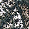
The Trans-Canada Highway going through Glacier National Park in British Columbia.
-
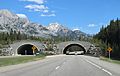
Highway 1 with a special wildlife overpass in Banff National Park, Alberta.
-
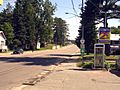
Highway 17 in Mattawa, Ontario.
-
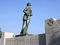
The statue of Terry Fox, located near where he stopped his amazing run near Thunder Bay, Ontario.
-
Highway 17 near Echo Bay, Ontario.
-
The Trans-Canada Highway through Ottawa on Ontario Highway 417.
-
Quebec Autoroute 20 heading east.
-
Highway 104 in Nova Scotia near Westville.
-
Route 1 in Newfoundland and Labrador near Corner Brook.
-
The Mile Zero monument at the start/end of the Trans-Canada Highway in Victoria, British Columbia.
-

Mary Brown's Centre in St. John's, Newfoundland and Labrador, once called "Mile One Centre."
See also
 In Spanish: Carretera transcanadiense para niños
- Canadian (train)
- List of Canadian highways by province
- Trans-Canada Trail
