
Saskatoon facts for kids
Quick facts for kids
Saskatoon
|
|||||
|---|---|---|---|---|---|
|
City
|
|||||
|
Downtown and the South Saskatchewan River
Broadway Bridge
|
|||||
|
|||||
| Nickname(s):
"Paris of the Prairies", "Toontown", "S'toon", "Hub City", "POW City" (for potash, oil and wheat), "The City of Bridges", "YXE", "Saskabush"
|
|||||

Saskatoon
Location in Canada

Saskatoon
Location in Saskatchewan
|
|||||
| Country | Canada | ||||
| Province | Saskatchewan | ||||
| Establishment | 1883 | ||||
| Incorporation | 1906 | ||||
| Area | |||||
| • Land | 226.56 km2 (87.48 sq mi) | ||||
| • Metro | 5,864.48 km2 (2,264.29 sq mi) | ||||
| Elevation | 481.5 m (1,579.7 ft) | ||||
| Population
(2021)
|
|||||
| • City | 266,141 (19th) | ||||
| • Density | 1,174.7/km2 (3,042/sq mi) | ||||
| • Metro | 317,480 (17th) | ||||
| • Metro density | 54.1/km2 (140/sq mi) | ||||
| Demonym(s) | Saskatonian | ||||
| Time zone | UTC−06:00 (CST) | ||||
| Forward sortation area |
S7A – S7C, S7H – S7W
|
||||
| Area code(s) | 306, 639, 474 | ||||
| Pronunciation | /ˌsæskəˈtuːn/ | ||||
| GDP (Saskatoon CMA) | CA$20.2 billion (2020) | ||||
| GDP per capita (Saskatoon CMA) | CA$64,447 (2016) | ||||
| Website | www.saskatoon.ca | ||||
.jpg)


Saskatoon (/ˌsæskəˈtuːn/) is the biggest city in the Canadian province of Saskatchewan. It sits along a bend in the South Saskatchewan River in the middle of the province. The city is located on the Trans-Canada Yellowhead Highway. It has been an important cultural and economic center for central Saskatchewan since it was founded in 1882. Back then, it started as a community that aimed to avoid alcohol.
In 2021, Saskatoon had a population of 266,141 people. This makes it the largest city in the province. The larger area around Saskatoon, called the Census Metropolitan Area, had 317,480 people in 2021. This makes it the 17th largest city area in Canada.
Saskatoon is home to the University of Saskatchewan. It also has the Meewasin Valley Authority, which helps protect the South Saskatchewan River and its popular park areas. Another important place is Wanuskewin Heritage Park. This is a National Historic Site of Canada and is being considered for a UNESCO World Heritage site. It shows 6,000 years of First Nations history. The city is surrounded by the Rural Municipality of Corman Park No. 344, which is the most populated rural area in Saskatchewan. This area includes places like Wanuskewin.
Saskatoon gets its name from the saskatoon berry. This berry grows naturally in the area. The name comes from the Cree word misâskwatômina. The city has a large Indigenous population and several urban Reserves. Saskatoon has nine bridges crossing the river. Because of this, it is often called "Paris of the Prairies" and "Bridge City".
Some of Saskatoon's old neighborhoods include Nutana and Riversdale. These were separate towns before they joined with Saskatoon to become a city in 1906. Broadway Avenue in Nutana and 20th Street in Riversdale are historic main streets. These areas, along with the downtown core, are being updated and redeveloped. Sutherland was a railway town located beyond the University of Saskatchewan lands. It became part of the city in 1956.
Contents
- What Does the Name Saskatoon Mean?
- Saskatoon's History: How it Grew
- Exploring Saskatoon's Geography
- Who Lives in Saskatoon?
- Saskatoon's Culture and Fun
- Saskatoon's Economy: How the City Makes Money
- Saskatoon's Infrastructure: How the City Works
- Learning in Saskatoon: Education
- Sports and Fun Activities
- Saskatoon and the Canadian Royal Family
- Saskatoon's Sister Cities
- Images for kids
- See also
What Does the Name Saskatoon Mean?
The name Saskatoon comes from the Cree word misâskwatômina. This word means "saskatoon berries". These are sweet, purple berries that grow in the area. The exact story of how the city got its name isn't fully clear.
The city's founder, John Lake, told different stories. One famous story says that in August 1883, he was given some berries. When he learned their name, he supposedly said, "Arise Saskatoon Queen of the North!" It's most likely that the name came from an older Cree name, manemesaskwatan. This meant "the place where willows are cut". The Cree people used saskatoon berry willows to make arrow shafts.
Saskatoon's History: How it Grew
In 1882, a group from Toronto called the Temperance Colonization Society received land. This land was along the South Saskatchewan River. Their goal was to create a "dry" community, meaning no alcohol, in the Prairie region. The next year, settlers led by John Neilson Lake arrived. They started the first permanent settlement where Saskatoon is now. The settlers traveled by train to Moose Jaw. Then, they used horse-drawn carts to reach Saskatoon, as the railway wasn't finished yet.

In 1885, the North-West Rebellion impacted the small community. Chief Whitecap and Charles Trottier passed through the area that is now the University campus. They were on their way to join Louis Riel's forces at Batoche, Saskatchewan. After battles like Battle of Fish Creek and Battle of Batoche, wounded Canadian soldiers recovered at the Marr Residence. This building is now a historic site. Some soldiers died there and were buried in the Nutana Pioneer Cemetery.
The west side of the river became a town called Saskatoon in 1903. The original settlement was renamed Nutana. In 1906, Saskatoon officially became a city. It had a population of 4,500 people, including the communities of Saskatoon, Riversdale, and Nutana. Later, Montgomery Place was added to the city in 1955. The nearby town of Sutherland joined in 1956. Saskatoon is now a main center for the northern prairies and central Saskatchewan.
Exploring Saskatoon's Geography
Saskatoon is located in the middle of southern Saskatchewan. It sits on rich, dark soil called chernozem. The area is part of the aspen parkland biome. There are no mountains nearby, so the city's layout is mostly flat. However, it does spread over some small hills and into a few valleys. The lowest point in the city is the river. The highest point is in the Sutherland-College Park area.
The South Saskatchewan River divides Saskatoon into east and west sides. The city is also split into Suburban Development Areas (SDAs), which are made up of neighborhoods. Street addresses are marked as north or south, and east or west. West of the river, 22nd Street divides north and south addresses. Idylwyld Drive (north of 20th Street) and Avenue A (south of 20th) divide east and west. On the east side, Lorne Avenue divides east and west. Aird Street marks the north-south border. In the Sutherland community, Central Avenue is the east/west boundary.
Another important water feature is the Hudson Bay Slough. This is a leftover from a large body of water formed by glaciers. Most of it has been drained due to building, but a part of it is saved in RCAF Memorial Park. Some neighborhoods also have "man-made lakes," with Lakeview being the first.
Pike Lake and Blackstrap Provincial Parks are about 40 kilometers (25 miles) south of the city. They are popular places for school trips. Batoche, a national historic site from the 1885 North-West Rebellion, is 90 kilometers (56 miles) north of the city.
Saskatoon's Climate: Seasons and Weather
Saskatoon has a climate that is between a cold semi-arid climate and a humid continental climate. This means it has warm summers and long, cold winters. The city usually has dry weather, with about 352.3 mm (13.87 inches) of rain and snow each year. Summer is the wettest season.
Saskatoon gets a lot of sunshine, averaging 2,350.4 hours each year. Extreme temperatures usually come with low humidity. Thunderstorms are common in summer. They can bring heavy rain, hail, strong winds, and sometimes even tornadoes. The time without frost, when plants can grow, is from May 21 to September 15. However, because Saskatoon is so far north, damaging frosts can happen as late as June and as early as August. The average high temperature in summer is 25.8°C (78.4°F).
The "Blizzard of 2007" was a very strong snowstorm. Many people said it was the worst they had seen. It brought low visibility, extreme cold, and a lot of snow. Winds reached over 90 km/h (56 mph), and about 25 cm (9.8 inches) of snow fell. Many people had to stay overnight at their workplaces, shopping centers, or the university.
The hottest temperature ever recorded in Saskatoon was 41.0°C (105.8°F) on June 6, 1988. The coldest temperature ever recorded was -50.0°C (-58.0°F) on February 1, 1893.
| Climate data for Saskatoon SRC (University of Saskatchewan), 1991–2020 normals, extremes 1915–present | |||||||||||||
|---|---|---|---|---|---|---|---|---|---|---|---|---|---|
| Month | Jan | Feb | Mar | Apr | May | Jun | Jul | Aug | Sep | Oct | Nov | Dec | Year |
| Record high °C (°F) | 8.9 (48.0) |
12.8 (55.0) |
20.0 (68.0) |
33.3 (91.9) |
36.7 (98.1) |
41.0 (105.8) |
40.1 (104.2) |
39.7 (103.5) |
35.9 (96.6) |
32.2 (90.0) |
20.0 (68.0) |
13.3 (55.9) |
41.0 (105.8) |
| Mean daily maximum °C (°F) | −9.5 (14.9) |
−7.3 (18.9) |
−0.1 (31.8) |
10.4 (50.7) |
18.5 (65.3) |
22.3 (72.1) |
25.3 (77.5) |
25.0 (77.0) |
19.4 (66.9) |
10.0 (50.0) |
−0.4 (31.3) |
−7.5 (18.5) |
8.8 (47.8) |
| Daily mean °C (°F) | −14.3 (6.3) |
−12.2 (10.0) |
−5.1 (22.8) |
4.4 (39.9) |
11.6 (52.9) |
16.3 (61.3) |
19.0 (66.2) |
18.3 (64.9) |
12.9 (55.2) |
4.7 (40.5) |
−4.6 (23.7) |
−11.9 (10.6) |
3.0 (37.4) |
| Mean daily minimum °C (°F) | −19.0 (−2.2) |
−17.1 (1.2) |
−10.0 (14.0) |
−1.7 (28.9) |
4.7 (40.5) |
10.2 (50.4) |
12.6 (54.7) |
11.5 (52.7) |
6.3 (43.3) |
−0.7 (30.7) |
−8.8 (16.2) |
−16.2 (2.8) |
−2.7 (27.1) |
| Record low °C (°F) | −46.1 (−51.0) |
−45.0 (−49.0) |
−38.9 (−38.0) |
−27.8 (−18.0) |
−10.0 (14.0) |
−3.9 (25.0) |
0.0 (32.0) |
−2.8 (27.0) |
−10.6 (12.9) |
−25.6 (−14.1) |
−33.9 (−29.0) |
−42.2 (−44.0) |
−46.1 (−51.0) |
| Average precipitation mm (inches) | 13.2 (0.52) |
9.1 (0.36) |
11.2 (0.44) |
23.3 (0.92) |
37.6 (1.48) |
73.9 (2.91) |
60.1 (2.37) |
46.4 (1.83) |
33.4 (1.31) |
20.4 (0.80) |
13.8 (0.54) |
9.9 (0.39) |
352.3 (13.87) |
| Average rainfall mm (inches) | 0.4 (0.02) |
0.2 (0.01) |
2.4 (0.09) |
16.2 (0.64) |
34.4 (1.35) |
63.6 (2.50) |
53.8 (2.12) |
44.4 (1.75) |
36.8 (1.45) |
9.7 (0.38) |
1.1 (0.04) |
0.9 (0.04) |
263.8 (10.39) |
| Average snowfall cm (inches) | 14.2 (5.6) |
8.9 (3.5) |
12.1 (4.8) |
5.6 (2.2) |
2.1 (0.8) |
0.0 (0.0) |
0.0 (0.0) |
0.0 (0.0) |
1.3 (0.5) |
9.1 (3.6) |
11.3 (4.4) |
11.9 (4.7) |
76.6 (30.2) |
| Average precipitation days (≥ 0.2 mm) | 11.5 | 8.1 | 9.8 | 9.3 | 9.3 | 13.4 | 12.0 | 9.4 | 8.0 | 8.8 | 8.8 | 10.3 | 118.7 |
| Average rainy days (≥ 0.2 mm) | 0.5 | 0.2 | 1.9 | 5.7 | 9.5 | 12.2 | 10.5 | 9.5 | 8.8 | 5.3 | 1.1 | 0.4 | 65.5 |
| Average snowy days (≥ 0.2 cm) | 9.1 | 7.1 | 6.9 | 2.6 | 0.5 | 0.0 | 0.0 | 0.0 | 0.3 | 2.9 | 6.2 | 9.3 | 44.9 |
| Mean monthly sunshine hours | 105.3 | 139.6 | 204.0 | 231.4 | 274.7 | 253.0 | 305.5 | 276.9 | 214.7 | 158.7 | 97.4 | 89.2 | 2,350.4 |
| Percent possible sunshine | 40.6 | 50.0 | 55.2 | 55.3 | 56.3 | 50.6 | 60.9 | 61.2 | 56.7 | 48.3 | 36.9 | 36.8 | 52.4 |
| Average ultraviolet index | 1 | 1 | 2 | 4 | 5 | 6 | 7 | 6 | 4 | 2 | 1 | 0 | 3 |
| Source 1: University of Saskatchewan | |||||||||||||
| Source 2: Environment and Climate Change Canada (rain, snow 1981–2010), Weather Atlas (UV) | |||||||||||||
| Climate data for Saskatoon International Airport, 1991–2020 normals, extremes 1892–present | |||||||||||||
|---|---|---|---|---|---|---|---|---|---|---|---|---|---|
| Month | Jan | Feb | Mar | Apr | May | Jun | Jul | Aug | Sep | Oct | Nov | Dec | Year |
| Record high humidex | 6.8 | 7.6 | 19.2 | 30.6 | 36.0 | 42.7 | 43.9 | 42.0 | 38.7 | 30.0 | 19.3 | 10.7 | 43.9 |
| Record high °C (°F) | 10.0 (50.0) |
12.8 (55.0) |
22.8 (73.0) |
33.3 (91.9) |
37.2 (99.0) |
40.6 (105.1) |
40.5 (104.9) |
38.6 (101.5) |
35.7 (96.3) |
32.2 (90.0) |
21.7 (71.1) |
14.4 (57.9) |
40.6 (105.1) |
| Mean daily maximum °C (°F) | −10.0 (14.0) |
−7.9 (17.8) |
−0.7 (30.7) |
10.5 (50.9) |
18.3 (64.9) |
22.1 (71.8) |
25.0 (77.0) |
24.8 (76.6) |
19.1 (66.4) |
9.9 (49.8) |
−0.7 (30.7) |
−8.0 (17.6) |
8.5 (47.4) |
| Daily mean °C (°F) | −15.4 (4.3) |
−13.4 (7.9) |
−6.1 (21.0) |
3.9 (39.0) |
10.9 (51.6) |
15.6 (60.1) |
18.3 (64.9) |
17.4 (63.3) |
11.9 (53.4) |
3.7 (38.7) |
−5.6 (21.9) |
−13.0 (8.6) |
2.3 (36.2) |
| Mean daily minimum °C (°F) | −20.7 (−5.3) |
−18.9 (−2.0) |
−11.4 (11.5) |
−2.6 (27.3) |
3.4 (38.1) |
9.0 (48.2) |
11.5 (52.7) |
10.0 (50.0) |
4.7 (40.5) |
−2.4 (27.7) |
−10.4 (13.3) |
−18.0 (−0.4) |
−3.8 (25.1) |
| Record low °C (°F) | −48.9 (−56.0) |
−50.0 (−58.0) |
−43.3 (−45.9) |
−28.3 (−18.9) |
−12.8 (9.0) |
−3.3 (26.1) |
−0.6 (30.9) |
−2.8 (27.0) |
−11.1 (12.0) |
−25.6 (−14.1) |
−39.4 (−38.9) |
−43.9 (−47.0) |
−50.0 (−58.0) |
| Record low wind chill | −60.9 | −59.0 | −50.1 | −38.3 | −16.2 | −7.7 | 0.0 | −4.8 | −14.5 | −33.4 | −46.4 | −57.6 | −60.9 |
| Average precipitation mm (inches) | 14.2 (0.56) |
9.1 (0.36) |
13.6 (0.54) |
23.0 (0.91) |
42.3 (1.67) |
75.0 (2.95) |
58.8 (2.31) |
42.5 (1.67) |
32.2 (1.27) |
20.8 (0.82) |
14.2 (0.56) |
11.6 (0.46) |
357.3 (14.08) |
| Average rainfall mm (inches) | 0.8 (0.03) |
1.0 (0.04) |
4.6 (0.18) |
17.7 (0.70) |
39.3 (1.55) |
71.9 (2.83) |
61.1 (2.41) |
45.8 (1.80) |
34.9 (1.37) |
13.8 (0.54) |
1.7 (0.07) |
0.9 (0.04) |
293.5 (11.56) |
| Average snowfall cm (inches) | 19.7 (7.8) |
11.2 (4.4) |
13.9 (5.5) |
7.5 (3.0) |
1.3 (0.5) |
0.0 (0.0) |
0.0 (0.0) |
0.0 (0.0) |
0.3 (0.1) |
7.4 (2.9) |
13.0 (5.1) |
16.7 (6.6) |
91.0 (35.8) |
| Average precipitation days (≥ 0.2 mm) | 11.2 | 8.2 | 8.4 | 8.5 | 9.1 | 12.5 | 12.4 | 9.9 | 8.9 | 7.6 | 8.8 | 10.2 | 115.7 |
| Average rainy days (≥ 0.2 mm) | 0.71 | 0.82 | 1.8 | 6.9 | 9.4 | 12.4 | 12.1 | 9.7 | 8.4 | 5.9 | 1.2 | 1.1 | 70.4 |
| Average snowy days (≥ 0.2 cm) | 13.2 | 8.8 | 8.7 | 3.8 | 0.65 | 0.0 | 0.0 | 0.0 | 0.29 | 2.7 | 8.2 | 10.8 | 57.1 |
| Average relative humidity (%) (at 15:00 LST) | 74.9 | 74.4 | 68.5 | 47.0 | 41.0 | 50.7 | 52.5 | 47.9 | 48.0 | 54.9 | 70.5 | 75.9 | 58.9 |
| Source: Environment and Climate Change Canada | |||||||||||||
Who Lives in Saskatoon?
{{Historical populations |title = Historical populations |type = Canada |align = right |width = |state = |shading = |percentages = |footnote = |1901|113 |1911|12004 |1921|25739 |1931|43291 |1941|43027 |1951|53268 |1956|72858 |1961|95526 |1966|115892 |1971|126449 |1976|133750 |1981|154210 |1986|177641 |1991|186058|1996|193653 |2001|196811 |[[Canada 2006 Census|202340 |2011|222246 |2016|246376|2021|266141}}
| Canada census – Saskatoon community profile | |||
|---|---|---|---|
| 2016 | 2011 | 2006 | |
| Population: | 246,376 (10.6% from 2011) | 222,189 (9.8% from 2006) | 202,340 (2.8% from 2001) |
| Land area: | 228.13 km2 (88.08 sq mi) | 209.56 km2 (80.91 sq mi) | 170.83 km2 (65.96 sq mi) |
| Population density: | 1,080.0/km2 (2,797/sq mi) | 1,060.3/km2 (2,746/sq mi) | 1,184.4/km2 (3,068/sq mi) |
| Median age: | 35.8 (M: 34.8, F: 36.9) | 35.6 (M: 34.2, F: 37.0) | 35.9 (M: 34.2, F: 37.4) |
| Total private dwellings: | 107,098 | 96,257 | 89,646 |
| Median household income: | $79,001 | $68,288 | $49,313 |
| References: 2016 2011 2006 earlier | |||
In the 2021 Canadian census, Saskatoon had 266,141 people living there. This was a 7.7% increase from 2016. The city has a land area of 226.56 square kilometers (87.48 square miles). This means there were about 1,174.7 people per square kilometer (3,042.4 per square mile). The population is almost evenly split between women (50.9%) and men (49.1%).
The larger Saskatoon area, called the Census Metropolitan Area (CMA), had 317,480 people in 2021. This was a 7.6% increase from 2016. The CMA covers a much larger area of 5,864.48 square kilometers (2,264.29 square miles).
In 2021, about 53,210 people in Saskatoon were immigrants. This means they were born outside Canada. This makes up 20.4% of the city's population. The top countries people came from were the Philippines, India, China, and Pakistan.
Saskatoon's Diverse Ethnic Backgrounds

The Saskatoon area was home to people long before the city was built. This is shown by the ongoing work at Wanuskewin Heritage Park. Many First Nations people now live in cities. Saskatoon is a good example of this. The First Nations population in Saskatoon grew a lot from 1981 to 2001. Most First Nations residents are from the Cree or Dakota groups. Some are also Saulteaux, Assiniboine, and Dene.
Saskatoon has the second highest percentage of Indigenous people among major Canadian cities, at about 11.5%. Only Winnipeg has more. In some neighborhoods, like Pleasant Hill, this number is over 40%.
The city also has a large Métis population. It is close to important historical Métis settlements to the north.
| Ethnic Origin | Population | Percent |
|---|---|---|
| German | 59,110 | 22.7% |
| English | 48,140 | 18.4% |
| Scottish | 40,355 | 15.5% |
| Ukrainian | 37,740 | 14.5% |
| Irish | 33,855 | 13.0% |
| French n.o.s | 24,655 | 9.4% |
| Canadian | 20,900 | 8.0% |
| Norwegian | 16,175 | 6.2% |
| Polish | 13,990 | 5.4% |
| Filipino | 13,320 | 5.1% |
| Métis | 12,010 | 4.6% |
| Note: multiple responses permitted | ||
Religious Beliefs in Saskatoon
According to the 2021 census, most people in Saskatoon identify as Christian (51.7%). A large number (37.8%) reported having no religious affiliation. Other religions include Islam (5.0%), Hinduism (2.0%), and Sikhism (1.2%).
Saskatoon's Culture and Fun
Events and Festivals to Enjoy
Saskatoon's main place for arts is TCU Place. It is located downtown next to Midtown Plaza. Since it opened in 1967, it has hosted many concerts, plays, and events. It is also home to the Saskatoon Symphony Orchestra. The main theatre there was recently updated.
For big rock concerts and shows, SaskTel Centre is the place to go. It is Saskatchewan's largest arena. It can hold 15,195 people for sports and 14,000 for concerts. Famous musicians from Saskatoon include Joni Mitchell and The Sheepdogs. SaskTel Centre hosted the Juno Awards in 2007. These are Canada's top music awards.
Saskatoon has many festivals in the summer. These include:
- Shakespeare on the Saskatchewan Festival (plays by the river)
- The Great Plains Comedy Festival
- The Jazz Festival
- The Saskatchewan Children's Festival
- The Saskatoon Fringe Theatre Festival (different kinds of theatre)
- Saskatoon Folkfest (a festival celebrating different cultures)
- Canada Remembers Airshow

For over 25 years, Saskatoon has hosted "Cruise Weekend". This event brings together many antique cars, mostly from the 1960s. It usually happens on the last weekend of August. There are car shows, dances, and over 800 cars from all over western Canada. It's free to attend and enjoy the cars.
The city's yearly fair, now called the Saskatoon Exhibition, happens every August at Prairieland Park. It used to be called Pioneer Days or "The Ex". The dates were changed in the late 1990s so it wouldn't compete with the Calgary Stampede.
Saskatoon's Sikh community celebrates the festival of Vaisakhi with a parade in May. The French-speaking community also has many cultural events organized by the Fédération des francophones de Saskatoon.
Art Galleries and Museums to Visit

Saskatoon has several art museums. The Remai Modern is located at River Landing, by the South Saskatchewan River downtown. This art museum is a large building designed by Bruce Kuwabara. It holds over 8,000 pieces of art. Artists like Pablo Picasso and Georges Braque have their work displayed here. The Remai Modern opened on October 21, 2017. It was even listed by the New York Times as one of the "52 places to go in 2018." The Remai Modern took over the collection from the old Mendel Art Gallery.
The Saskatchewan Craft Council Gallery shows fine craft as an art form. It is located on Broadway Avenue. They have seven to eight exhibitions each year. Their boutique sells works from over 75 craft artists.
The Ukrainian Museum of Canada is on the banks of the South Saskatchewan River. It was started in 1941 by the Ukrainian Women's Association of Canada.

The Meewasin Valley Centre in Friendship Park provides information about Saskatoon's history. It also shares details about the South Saskatchewan River and the future of the Meewasin Valley.
Saskatoon is also home to the Saskatchewan Western Development Museum. This museum shows what early pioneer life in Saskatchewan was like. It has a recreated "Boom Town" main street inside. The Saskatchewan Railway Museum is just outside the city. It has old trains and historic railway buildings.
The Forestry Farm Park and Zoo is a National Historic Site in the northeast part of the city. It used to be a tree nursery that grew many trees for the prairie provinces. In 1966, it became a city park and zoo. The zoo has over 80 different kinds of animals.
Wanuskewin Heritage Park is a National Historic Site five kilometers (3 miles) north of Saskatoon. It is an Indigenous archaeological site. It offers displays, special events, and activities.
Live Theatres and Movie Theatres

Live theatre is a big part of Saskatoon's culture. There are several live theatre venues, such as the Persephone Theatre. It is in the Remai Arts Centre at River Landing downtown. Other theatres include The Refinery and the Saskatchewan Native Theatre Company.
The Broadway Theatre mainly shows arthouse films. The two-screen Roxy Theatre is a "second-run" theatre. It shows movies that have already been in big cinemas. It reopened in 2005 after being closed for over ten years. Most other movie theatres in the city are multiplexes (theatres with many screens).
The only movie theatre downtown is the Scotia Bank VIP Theatre. The city's other movie theatres are The Landmark Theatre in Brighton and Cineplex Cinemas at The Centre mall.
Other Fun Places to Visit
One of Saskatoon's famous buildings is the Delta Bessborough Hotel. Locals call it the Bez. It was built by the Canadian National Railway. It was one of the last grand railway hotels started before the Great Depression. Even though it was finished in 1932, it didn't open until 1935 because of the hard economic times. The Bessborough and the Mendel Art Gallery are the only big buildings on the river side of Spadina Crescent. A popular photo of Saskatoon shows the hotel framed by one of the arches of the Broadway Bridge.

The Meewasin Valley Trail runs along the South Saskatchewan River through Saskatoon. In summer, people enjoy biking, jogging, and walking through parks and natural areas. In winter, cross-country skiing is popular, along with skating at Kiwanis Memorial Park. There are many access points to the trail with signs and washrooms. The Meewasin Skating Rink is free to use in winter. It's next to the Delta Bessborough hotel.
The Saskatoon Farmers' Market is a great place to find local food and goods. Other landmarks include the University of Saskatchewan campus. The large Viterra grain terminal is also a well-known sight. It can be seen from far away and has been a part of the city's western skyline for many years.
Shopping Centres in Saskatoon
- Blairmore Shopping Centre
- The Centre
- Confederation Mall
- Erindale Centre/University Heights Mall
- The Mall at Lawson Heights
- Market Mall
- Midtown Plaza
- Preston Crossing
- River City Mall
- Stonegate Shopping Centre (in Stonebridge)
Saskatoon's Economy: How the City Makes Money

Saskatoon's economy is known for potash, oil, and agriculture (especially wheat). This is why it's sometimes called "POW City". The city's economy is driven by various grains, livestock, oil and gas, potash, uranium, gold, diamonds, coal, and related industries. The world's largest publicly traded uranium company, Cameco, has its main office in Saskatoon. Also, the world's largest potash producer, Nutrien, is based here.

Almost two-thirds of the world's usable potash is found in the Saskatoon area. Innovation Place, started in 1980, brings together many companies. These companies work in agriculture, information technology, environmental sciences, and biotechnology. Saskatoon is also home to the Canadian Light Source. This is Canada's national synchrotron facility, used for scientific research.

Saskatoon's digital media scene is growing. It has tech companies like Noodlecake, Point2, Vendasta Technologies, and Zu.
One of Saskatoon's nicknames is "Hub City." This is because it's in a great central spot in Canada for moving goods and services. Saskatoon John G. Diefenbaker International Airport is a busy airport. It is an important center for mining and remote areas in Northern Saskatchewan.
Saskatoon's economy has been growing. The city was expected to see a 4.2% growth in its gross domestic product (GDP) in 2012. In 2005, Saskatoon had the highest economic growth in Canada.
Saskatoon's Infrastructure: How the City Works
Keeping the City Safe: Policing

The Saskatoon Police Service is the main police force for the city. They have authority both in the city and across the province. Other police services that work in Saskatoon include the Corman Park Police Service, the Royal Canadian Mounted Police, and railway police services. As of 2012, the Saskatoon Police Service had 442 sworn officers.
Getting Around: Transportation

Roads and Bridges
Saskatoon is located on the Yellowhead Highway. This highway is part of the Trans-Canada Highway system. It connects Saskatchewan with Manitoba, Alberta, and British Columbia. Many other highways also meet in Saskatoon.
The following bridges cross the South Saskatchewan River in Saskatoon, from upstream (south) to downstream (north):
- Grand Trunk Bridge (for trains)
- Gordie Howe Bridge
- Senator Sid Buckwold Bridge
- Traffic Bridge
- Broadway Bridge
- University Bridge
- CPR Bridge (for trains)
- Circle Drive Bridge
- Chief Mistawasis Bridge
Building Saskatoon's ring road, called Circle Drive, started in the 1960s. It was fully finished on July 31, 2013.

Trains
Both the Canadian Pacific Railway and the Canadian National Railway have lines in Saskatoon. Saskatoon is a stop on The Canadian passenger train route. This route is operated by Via Rail and travels across Canada. The Saskatoon railway station is in the west end of the city. It opened in the late 1960s. The old main station was downtown. Moving the station led to big changes downtown, including the building of the Midtown Plaza.
Saskatoon's many transportation links and its central location give it the nickname The Hub City. The Saskatchewan Railway Museum is just outside the city.
Air Travel
Saskatoon/John G. Diefenbaker International Airport is in the northwest part of the city. It offers flights for passengers and cargo. It's an important hub for mining and remote areas in Northern Saskatchewan. You can fly directly to cities like Calgary, Edmonton, Toronto, and Vancouver. Seasonal and charter flights also go to places like Mexico and Cuba.

Bus Services
Bus services within Saskatoon are provided by Saskatoon Transit. The bus route system was updated in 2018. It now has frequent bus services on main streets like 22nd Street and 8th Street.
Learning in Saskatoon: Education

Saskatoon has several places for higher education:
- University of Saskatchewan
- St. Thomas More College (a Catholic college connected to the University of Saskatchewan)
- The First Nations University of Canada – Saskatoon campus
- Saskatchewan Polytechnic
- Gabriel Dumont Institute
- Saskatchewan Indian Institute of Technologies
Saskatoon has 78 elementary schools and 14 high schools. These schools serve about 37,000 students. There are three main school boards in Saskatoon: the Saskatoon Public School Division, the Saskatoon Catholic School Division, and the Conseil des Ecoles Fransaskoises (for French-speaking students).
Sports and Fun Activities

Ice hockey is a very popular sport in Saskatoon. The city has many amateur teams. It is also home to the Saskatoon Blades of the Western Hockey League (WHL). Saskatoon had a major league hockey team from 1921 to 1926, called the Saskatoon Sheiks. In 1982, there was an attempt to bring an NHL team to Saskatoon. The city even built a new arena for it, but the move didn't happen.
Saskatoon has two professional sports teams:
- The Saskatchewan Rush (lacrosse, NLL)
- The Saskatchewan Rattlers (basketball, CEBL)
The Rush moved to Saskatoon in 2016 and won championships in 2016 and 2018. The Rattlers won the first CEBL championship in 2019.

Canadian football is also very popular. The University of Saskatchewan Huskies are one of Canada's top university football teams. They have won three national championships. The Saskatoon Hilltops have won 22 national junior championships, which is the most in the country. The Saskatoon Valkyries are a very successful women's football team.
The Huskies play their games at the University campus. Their facilities include Griffiths Stadium and Merlis Belsher Place.

Baseball is popular too. The Saskatoon Berries joined the Western Canadian Baseball League in 2024.
Saskatchewan International Raceway has been open for over 40 years. It hosts drag racing events from May to September. North of the city is Wyant Group Raceway, a paved oval track for stock car racing.
The city has many sports and recreation centers. Saskatoon has three curling clubs. It also has two indoor soccer facilities. Lions Skatepark was built in 2003. Saskatoon has several golf courses and parks with tennis courts, baseball diamonds, and soccer fields for different seasons.
Major Sports Events Hosted in Saskatoon
| Event | Sport | Year |
|---|---|---|
| Canada Games | Various | 1971 (Winter), 1989 (Summer) |
| Montana's Brier | Curling | 1946, 1965, 1989, 2000, 2004, 2012 |
| Scotties Tournament of Hearts | Curling | 1972, 1991 |
| Canadian Olympic Curling Trials | Curling | 2021 |
| Memorial Cup | Hockey | 1989, 2013 |
| 4 Nations Cup | Hockey | 2018 4 Nations Cup |
| IIHF World Junior Championship | Hockey | 1991, 2010 |
| U Sports University Cup | Hockey | 1998, 1999, 2000, 2013, 2014 |
| Canadian Ringette Championships | Ringette | 1994, 2010 |
| Canadian Figure Skating Championships | Figure skating | 1991, 2003, 2009 |
| U-18 Baseball World Cup | Baseball | 1984 |
| Women's Softball World Cup | Baseball | 2002 |
| Men's Softball World Cup | Baseball | 1988, 2009, 2015 |
| CEBL Championship Weekend | Basketball | 2019 |
| FIVB Volleyball Women's U21 World Championship | Volleyball | 1999 |
Saskatoon and the Canadian Royal Family

Saskatoon has welcomed members of the Royal Family many times since 1919. Queen Elizabeth II visited most recently in 2005 for a concert. She was given the key to the city during that visit. She also toured the Canadian Light Source synchrotron and met many people at the University of Saskatchewan. The Queen traditionally stayed at the University President's home when she visited.
Other members of the Royal Family who have visited include Edward VIII (as Prince of Wales) in 1919. King George VI and Queen Elizabeth visited in 1939. Elizabeth II and the Duke of Edinburgh visited several times.
Many places in Saskatoon are named after royals. These include neighborhoods like King George and Queen Elizabeth. Parks like Victoria Park and Princess Diana Park also carry royal names. The Royal University Hospital is one of four places in Saskatchewan with a "royal" designation. Schools like Ecole Victoria School and King George School are also named after royals.
The Hotel Bessborough was named after a Canadian Governor General who visited it while it was being built. The Queen Elizabeth Power Station in the city is named after Queen Elizabeth. The Prince of Wales Promenade along the South Saskatchewan River is a key part of the riverfront trails.
Saskatoon's Sister Cities
Saskatoon has partnerships with three cities around the world:
- Chernivtsi, Ukraine (since 1991)
- Shijiazhuang, China (since 1985)
- Umeå, Sweden (since 1975)
Images for kids
-
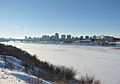
Winter skyline of Saskatoon with the South Saskatchewan River bisecting the city. Winters in the city are long, and cold.
-
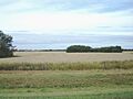
View of the Aspen parkland outside the city limits. The area is a transitional biome between the boreal forest and prairies.
-
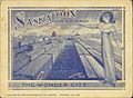
A small booklet showing a woman standing over a busy trainyard in Saskatoon.


See also
 In Spanish: Saskatoon para niños
