
Ontario Highway 17 facts for kids
Quick facts for kids
|
||||
|---|---|---|---|---|
| Trans-Canada Highway | ||||
 |
||||
| Route information | ||||
| Length | 1,964.0 km (1,220.4 mi) | |||
| Existed | February 26, 1920–present | |||
| Tourist routes |
||||
| Major junctions | ||||
| West end | ||||
| East end | ||||
| Location | ||||
| Major cities: | Kenora, Dryden, Ignace, Thunder Bay, Wawa, Sault Ste. Marie, Sudbury, North Bay, Mattawa, Petawawa, Pembroke, Arnprior | |||
| Highway system | ||||
|
||||


Ontario Highway 17 is a very important road in Ontario, Canada. It is also known as the Trans-Canada Highway in this province. This highway is super long, stretching for about 1,964 kilometers (1,220 miles). This makes it the longest highway in all of Ontario!
Highway 17 starts way out west, near the border with Manitoba, close to the town of Kenora. It travels all the way across Ontario, ending near Arnprior. There, it joins up with another big highway, Ontario Highway 417.
Contents
Exploring Highway 17
Highway 17 is a huge part of the Trans-Canada Highway system. This system connects Canada from coast to coast. Imagine driving across the entire country! Highway 17 is the main part of that journey through Ontario.
Where Does It Go?
This highway travels through many different parts of Ontario. It starts in the forests and lakes of Northwestern Ontario. Then, it follows the beautiful northern shore of Lake Superior. This part of the drive offers amazing views of the lake and rocky cliffs.
As it continues east, Highway 17 passes through many cities and towns. Some of the bigger places it goes through include Thunder Bay, Sault Ste. Marie, and Sudbury. It also connects smaller communities, helping people travel for work, school, or fun.
Connecting Communities
Highway 17 is like a lifeline for many communities in Northern Ontario. Before this highway was fully built, it was much harder to travel between towns. The highway helps people and goods move easily. This helps businesses and makes life better for everyone.
It also helps tourists explore Ontario's natural beauty. Many people use Highway 17 to visit parks, lakes, and other attractions. It's a key route for anyone wanting to see the province.
A Bit of History
Highway 17 officially started on February 26, 1920. But it took many years to build the entire road. Sections were added and improved over time. One big moment was the opening of the Trans-Canada Highway in Ontario. A special ceremony happened on September 17, 1960, near Wawa. This marked a huge step in connecting the country.
Over the years, parts of Highway 17 have been upgraded. Some sections are now wider with more lanes. This helps traffic flow better and makes the road safer. The highway continues to be an important route for travel and trade in Ontario.
Images for kids
-
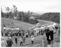
The official ceremony for the opening of the Lake Superior Circle Tour and the Trans-Canada Highway was held on September 17, 1960, near Wawa.
-
Highway 17 at Nipigon Bay in 1937.
-
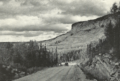
A gravel-surfaced Highway 17 near Kenora in 1939
-
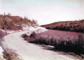
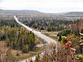
Highway 17 divides mountains on its journey along the north shore of Lake Superior
-
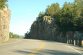
Highway 17 near Wawa
-
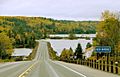
Highway 17 meets the Ottawa River in Deux Rivieres
-
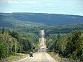
Highway 17 looking east towards Stonecliffe
-
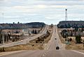
One of the few short sections of 4-lane divided Highway 17 between Echo Bay and Desbarats
-

A new route east of Cobden has been selected by the MTO
-

The Nipigon River Bridge, of the cable stayed design, carries Highway 11/17 over the Nipigon River.


