
Ontario Highway 6 facts for kids
Quick facts for kids
|
||||
|---|---|---|---|---|
| Garafraxa Road | ||||
 |
||||
| Route information | ||||
| Length | 472.4 km (293.5 mi) | |||
| Existed | June 1920–present | |||
| Major junctions | ||||
| South end | St. Patrick Street - Port Dover | |||
| North end | ||||
| Location | ||||
| Major cities: | Hamilton, Guelph, Owen Sound | |||
| Towns: | Port Dover, Jarvis, Hagersville, Caledonia, Ancaster, Aberfoyle, Fergus, Arthur, Mount Forest, Durham, Chatsworth, Shallow Lake, Wiarton, Tobermory, Little Current, Espanola | |||
| Highway system | ||||
|
||||

Ontario Highway 6 is a major road in Ontario, Canada. It's a provincial highway, meaning it's managed by the province. This highway is very long, stretching for about 472.4 kilometers (293.5 miles)!
Highway 6 starts in a town called Port Dover in the south. It then travels north all the way to Baldwin, Ontario, where it connects with the Trans Canada Highway (which is also known as Ontario Highway 17 in that area).
Because of a large body of water, the highway is split into two parts. To connect these parts, you can take a ferry! This ferry travels between Tobermory, which is at the very top of the Bruce Peninsula, and Tehkummah, located on Manitoulin Island.
Contents
Building Highway 6: A Look Back
Work on Highway 6 began a long time ago, in 1919. It took a few years to complete, with the main construction finishing by 1923. This made it one of the earlier highways built in Ontario.
Early Days of the Road
When it was first built, Highway 6 helped connect many towns and cities. It made it easier for people to travel and transport goods across the province. Over the years, parts of the highway have been updated and improved to handle more traffic.
Traveling Along Highway 6
Highway 6 passes through many different landscapes and communities. From the busy cities to the quiet countryside, it offers a varied journey.
Cities and Towns on the Route
As you travel on Highway 6, you'll go through several interesting places. Some of the bigger cities include Hamilton, Guelph, and Owen Sound. Many smaller towns are also along the way, like Port Dover, Jarvis, Mount Forest, and Wiarton. Each place has its own unique feel.
The Ferry Connection
One of the most unique parts of Highway 6 is the ferry ride. The Chi-Cheemaun ferry helps connect the northern part of the highway. It's a fun way to cross the water and continue your journey on the other side. This ferry is an important link for people traveling to and from Manitoulin Island.
Images for kids
-
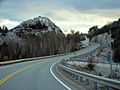
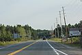
Looking south on Highway 6 through the La Cloche Mountains near Whitefish Falls
-
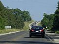
Highway 6 begins its connection with Highway 21 in Springmount, east of Owen Sound.
-
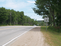
Highway 6 looking south near Wiarton.
-
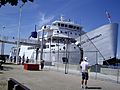
The Chi-Cheemaun ferry docking at Carlton Street
-
Looking south from the northern end of Highway 6
-
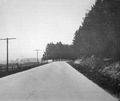
Highway 6 south of Guelph in 1921, showing how it looked in the early days.
-
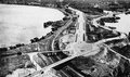
An early design for a grand road entrance in Hamilton, built in the 1930s.
-
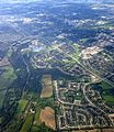
The Hanlon Expressway in Guelph, a modern part of Highway 6.


