Northeastern Manitoulin and the Islands facts for kids
Quick facts for kids
Northeastern Manitoulin and the Islands
|
|
|---|---|
| Town of Northeastern Manitoulin and the Islands | |
 |
|
| Country | Canada |
| Province | Ontario |
| District | Manitoulin |
| Established | January 1, 1998 |
| Government | |
| • Type | Town |
| Area | |
| • Land | 495.68 km2 (191.38 sq mi) |
| Population
(2011)
|
|
| • Total | 2,706 |
| • Density | 5.5/km2 (14/sq mi) |
| Time zone | UTC-5 (EST) |
| • Summer (DST) | UTC-4 (EDT) |
| Postal code |
P0P 1K0
|
| Area code(s) | 705 |
| Highways | |
| Website | www.townofnemi.on.ca |
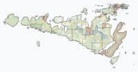
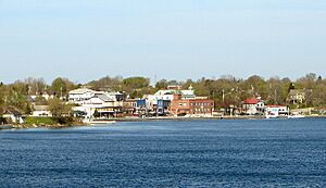
Northeastern Manitoulin and the Islands is a town in Manitoulin District in Northeastern Ontario, Canada. It is about 30 kilometers south of Espanola. The main part of the town is Little Current, found on the northeast side of Manitoulin Island. This area also includes many small islands around Manitoulin.
The town was formed on January 1, 1998. It combined the old Town of Little Current with the Township of Howland. It also included small, unorganized islands in Lake Huron. This town is also the main office for the Aundeck Omni Kaning First Nation government.
Contents
Exploring the Communities of Northeastern Manitoulin
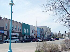
Little Current is the biggest community in the town. It is also where the town's government offices are located. Little Current got its name from the fast currents of water. These currents flow through a narrow passage. This passage connects the North Channel and Georgian Bay. In the past, it was called Waebijewung, Le Petit Courant, and Shaftesbury.
The town also has smaller communities. These include Cold Springs, Dinner Point Depot, Eads Bush, Green Bay, Honora, Rockville, and Sheguiandah.
Economy and Local Business
In the late 1800s, large lake boats would stop here. They took on wood to power their engines. A community grew around this activity. George Abotossaway, an Anishinaabe man, sold fuel to these boats.
Travelers from Upper Canada often came through. One family, the Turners, started a general store. This store is still open today.
Logging was very important back then. Sawmills were built on nearby Low Island. This island is now a park. Settlers also cleared land for farming.
Today, farming and logging are still part of the economy. But tourism is now a very important part of the town's income.
Transportation and Travel
This community is a safe place for boats on Lake Huron. You can find it on Canadian Hydrographic Chart #2205. Lighthouses and markers guide boats safely.
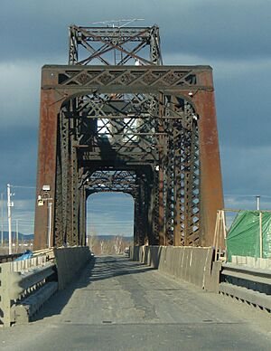
The only way to reach Manitoulin Island by land is the Little Current Swing Bridge. This bridge is on Highway 6. It crosses the North Channel of Lake Huron to the mainland. In summer, the bridge opens for boats every hour. This happens for 15 minutes from sunrise to sunset. This opening can cause delays for cars.
Long ago, Little Current was the end point for a railway line. This was the Algoma Eastern Railway. Later, it became a smaller part of the Canadian Pacific Railway. People used to travel by train because roads were difficult. Train service for passengers stopped in 1963. Over time, parts of the track were removed. Today, only a small section of the track remains. It connects a paper mill in Espanola to the main railway line.
In 2018, Ontario Northland started bus service to Manitoulin Island. Buses stopped in Little Current. Then they traveled around the island. This new route also included Sheguiandah. This was the first bus service on the island in many years. However, this bus service ended in 2019.
Climate and Weather Patterns
The climate here has warm, humid summers. Sometimes summers can be rainy or cooler. Winters are snowy and cold. The cold season is similar to other places in North America at the same latitude.
However, Lake Huron greatly affects the weather. The lake creates special local weather patterns. These are like those found in cities near the coast. For example, Asahikawa in Japan has a similar microclimate.
| Climate data for Little Current, 1981-2010 normals | |||||||||||||
|---|---|---|---|---|---|---|---|---|---|---|---|---|---|
| Month | Jan | Feb | Mar | Apr | May | Jun | Jul | Aug | Sep | Oct | Nov | Dec | Year |
| Record high °C (°F) | 8 (46) |
10 (50) |
19 (66) |
27 (81) |
29 (84) |
33 (91) |
36 (97) |
36 (97) |
31 (88) |
23 (73) |
18 (64) |
13 (55) |
36 (97) |
| Mean daily maximum °C (°F) | −5.9 (21.4) |
−3.8 (25.2) |
1.5 (34.7) |
10.3 (50.5) |
17.7 (63.9) |
22.5 (72.5) |
25.1 (77.2) |
24.1 (75.4) |
18.7 (65.7) |
11.7 (53.1) |
3.6 (38.5) |
−2.9 (26.8) |
10.2 (50.4) |
| Mean daily minimum °C (°F) | −16.7 (1.9) |
−15.6 (3.9) |
−10.5 (13.1) |
−1.5 (29.3) |
4.0 (39.2) |
8.9 (48.0) |
11.9 (53.4) |
11.0 (51.8) |
7.0 (44.6) |
1.9 (35.4) |
−4.1 (24.6) |
−11.9 (10.6) |
−1.3 (29.7) |
| Record low °C (°F) | −41 (−42) |
−41 (−42) |
−32 (−26) |
−15 (5) |
−5 (23) |
−1 (30) |
2 (36) |
0 (32) |
−7 (19) |
−8 (18) |
−29 (−20) |
−38 (−36) |
−41 (−42) |
| Source: Environment Canada, The Weather Network | |||||||||||||
Local Culture and Traditions
Every year, the town celebrates "Haweater Weekend." This is a week-long festival. It gets its name from "Haweaters," which is what people born on Manitoulin Island are called. The main events happen on the first weekend of August. These include fireworks, a video dance, street vendors, and a parade.
A famous American sportsman, John W. Galbreath, owned a summer home here. He owned the Pittsburgh Pirates baseball team. He also had a horse racing farm. He named one of his horses after the village. This horse, Little Current, won important races in 1974. These included the Preakness and Belmont Stakes. He was also named the best 3-year-old male horse that year.
Media and Communication
Radio Stations in the Area
The town has two local radio stations: CFRM and CHAW. You can also hear some radio stations from Sudbury here. Elliot Lake's CKNR can also be heard.
| Frequency | Call sign | Branding | Format | Owner | Notes |
|---|---|---|---|---|---|
| FM 94.1 | CKNR-FM | Moose FM | Adult contemporary | Vista Broadcast Group | |
| FM 97.5 | CBCE-FM | CBC Radio One | Talk radio, public radio | Canadian Broadcasting Corporation | Rebroadcaster of CBCS-FM Sudbury |
| FM 100.7 | CFRM-FM | Hits 100 | Community radio/adult hits | Manitoulin Radio Communication | |
| FM 102.1 | CJTK-FM-2 | KFM | Christian music | Harvest Ministries Sudbury | Rebroadcaster of CJTK-FM Sudbury |
| FM 103.1 | CHAW-FM | Country 103 | Country music | Manitoulin Radio Communication |
Local Newspaper
The main local newspaper is the weekly Manitoulin Expositor. It is the oldest newspaper still running in Northern Ontario.
Population and Demographics
In the 2021 Census, Northeastern Manitoulin and the Islands had a population of 2,641 people. They lived in 1,205 homes. This was a small decrease of 2.6% from its 2016 population of 2,712. The land area is about 489.19 square kilometers. This means there were about 5.4 people per square kilometer in 2021. The average age of people living here in 2021 was 55.6 years old.
| Canada census – Northeastern Manitoulin and the Islands community profile | |||
|---|---|---|---|
| 2011 | 2006 | ||
| Population: | 2706 (-0.2% from 2006) | 2711 (7.1% from 2001) | |
| Land area: | 495.68 km2 (191.38 sq mi) | 495.04 km2 (191.14 sq mi) | |
| Population density: | 5.5/km2 (14/sq mi) | 5.5/km2 (14/sq mi) | |
| Median age: | 47.4 (M: 46.7, F: 48.0) | ||
| Total private dwellings: | 2029 | 2044 | |
| Median household income: | $44,097 | ||
| References: 2011 2006 earlier | |||
 | John T. Biggers |
 | Thomas Blackshear |
 | Mark Bradford |
 | Beverly Buchanan |


