
Ontario Highway 5 facts for kids
Quick facts for kids
|
||||||||||
|---|---|---|---|---|---|---|---|---|---|---|

Highway 5 Route
Current Highway 5 Route Former Highway 5 Route 400 series highways |
||||||||||
| Route information | ||||||||||
| Length | 12.7 km (7.9 mi) | |||||||||
| Existed | 1920–present | |||||||||
| Major junctions | ||||||||||
| West end | ||||||||||
| East end | ||||||||||
| Location | ||||||||||
| Major cities: | Hamilton (Waterdown) | |||||||||
| Highway system | ||||||||||
|
||||||||||

Ontario Highway 5 is a road in Ontario, Canada. It's a special kind of road called a provincial highway. This means it's managed by the government of Ontario.
Highway 5 runs from west to east. It starts near Peter's Corners at Highway 8. It ends at Clappisons Corners where it meets Highway 6. The highway is about 12.7 kilometers (7.9 miles) long. It mostly goes through countryside areas.
Contents
What is Highway 5?
Highway 5 is a road that helps people travel across Ontario. It connects different towns and cities. This highway is important for drivers in the Hamilton area. It helps them get around quickly and safely.
Where Does it Go?
Highway 5 starts in the west near Dundas. It then travels east through Waterdown. The road ends close to Burlington. It's a busy route for both local traffic and people traveling longer distances.
How Long is Highway 5?
The main part of Highway 5 is about 12.7 kilometers long. That's about 7.9 miles. This makes it one of the shorter provincial highways in Ontario. Even though it's not super long, it connects important areas.
History of Highway 5
Highway 5 has been around for a long time. It was first made a provincial highway in 1920. Over the years, parts of the highway have changed. Some sections were moved or improved to make driving better.
Early Days of the Highway
When Highway 5 was first built, cars were very different. Roads were often not as smooth as they are today. The government wanted to make it easier for people to travel. So, they started building and improving highways like this one.
Changes Over Time
Over the decades, Highway 5 has seen many upgrades. Engineers worked to make the road safer and faster. They added new lanes and improved turns. Sometimes, old parts of the road were left behind. You can still see some of these old sections today.
The Clappison's Corners Cut
One big project was the "Clappison's Corners Cut." This was a huge job to make the highway straighter and flatter. Workers had to dig through a big hill. They used special rails to move away the earth and rocks. This made the road much better for drivers.
Improving Safety on the Road
In the past, highways had fewer safety features. Over time, new ideas were used to make roads safer. For example, "zone striping" was added. This meant painting lines on the road to show drivers where it was safe to pass other cars. This helped prevent crashes.
Images for kids
-
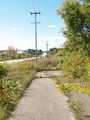
An abandoned section of highway lies in the bush next to the current route, north of Greensville
-
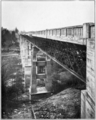
The high-level bridge over Sixteen Mile Creek opened in 1921, replacing a winding route through the ravine valley that exists today as an access road and park trail
-
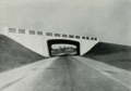
New grade separation between Highway 5 (Danforth Avenue) and Highway 2 (Kingston Road) in Scarborough in 1938
-
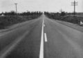
An early example of "zone striping" along Highway 5 near Clappison's Corners, which reduced head-on collisions by indicating ideal passing locations, with unobstructed sightlines, to drivers
-
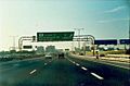
Highway 5 was signed through Toronto for several decades after it was downloaded to the city. Example shown is the interchange with Highway 427 which was inaugurated after that segment of Highway 5 was no longer provincially controlled.
-
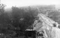
A set of rails were installed to remove excavated earth and rock
-
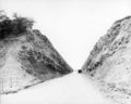
Completed work


