
Port Dover facts for kids
Quick facts for kids
Port Dover
|
|
|---|---|
|
Unincorporated hamlet in Norfolk County
|
|

Boats moored at Port Dover, Ontario
|
|

Port Dover
Location in Southern Ontario
|
|
| Country | |
| Province | |
| Established | 1794 as Dover Mills |
| Amalgamated into Norfolk County | 2001 (Single-tier municipality) |
| Area | |
| • Land | 5.66 km2 (2.19 sq mi) |
| Elevation | 210 m (690 ft) |
| Population
(2021)
|
7,871 |
| • Density | 1,087.8/km2 (2,817/sq mi) |
| Time zone | UTC-5 (EST) |
| • Summer (DST) | UTC-4 (EDT) |
| Forward sortation area |
N0A
|
| Area code(s) | 519 / 226 / |
| Website | norfolkcounty.ca |
Port Dover is a community in Norfolk County, Ontario, Canada. It is located on the northern shore of Lake Erie. Before the War of 1812, it was known as Dover Mills. Port Dover is famous for its special Friday the 13th motorcycle rally. Amy Martin, a resident of Port Dover, is the Mayor of Norfolk County.
Contents
About Port Dover
Port Dover is the end point for Ontario Highway 6 in the south. This highway stretches north for about 480 kilometers (300 miles) to McKerrow in Northern Ontario. It connects Port Dover to the city of Hamilton. The highway also links to Highway 403, which can take you to the Royal Botanical Gardens and Toronto.
The postal code area for Port Dover is N0A. This postal code is also used by the western part of Haldimand County. All phone numbers in Port Dover start with 583.
Many different kinds of birds have been seen in Port Dover. Between 1956 and 2019, at least 128 bird species were spotted. These include colorful birds like the Indigo bunting, the Rose-breasted grosbeak, and the Scarlet tanager.
Most people in Port Dover watch TV using satellite services like Shaw Direct or Bell Satellite TV. Some also use over-the-air antennas. One channel can be picked up easily with an outdoor antenna. Five more channels can be picked up sometimes. On clear, sunny days, twelve more channels might be available.
Ride Norfolk offers bus service between Port Dover and Simcoe on Thursdays and Fridays. This service helps people from Simcoe visit Port Dover's tourist spots, especially in summer. It also helps Port Dover residents get to doctors and dental services in Simcoe if they don't have a car.
People of Port Dover
Port Dover is the second largest community in Communities in Norfolk County, Ontario. In 2021, its population was 7,871 people. This was a 12.7% increase from 2016, when 6,984 people lived there. Most residents speak English. About 285 people speak other languages besides English or French.
Most people living in Port Dover were born in Canada. About 515 residents were born in Europe, 10 in Africa, 70 in the United States, and 70 in Asia. The average age of residents in 2016 was 50.8 years. The median household income in 2020 was $83,000.
Name Origin
Port Dover got its name from Dover, a port city in England.
Weather in Port Dover
Port Dover has a humid continental climate. This means it usually has warm, wet summers and cold winters. However, in recent years, winters have been milder and summers warmer and drier. This is due to changes in climate.
The warmest summers in Port Dover happened in 1998, 2003, 2005, 2006, 2007, 2009 (except July), 2010, 2012, 2013, 2014, 2015, and 2016.
| Climate data for Port Dover, Ontario (1961–1990) | |||||||||||||
|---|---|---|---|---|---|---|---|---|---|---|---|---|---|
| Month | Jan | Feb | Mar | Apr | May | Jun | Jul | Aug | Sep | Oct | Nov | Dec | Year |
| Record high °C (°F) | 13.9 (57.0) |
14.4 (57.9) |
22.8 (73.0) |
27.8 (82.0) |
32.2 (90.0) |
34.4 (93.9) |
40.0 (104.0) |
36.1 (97.0) |
33.3 (91.9) |
29.4 (84.9) |
24.4 (75.9) |
16.7 (62.1) |
40.0 (104.0) |
| Mean daily maximum °C (°F) | −2.2 (28.0) |
−1.0 (30.2) |
4.2 (39.6) |
11.0 (51.8) |
17.8 (64.0) |
22.9 (73.2) |
25.9 (78.6) |
25.1 (77.2) |
20.9 (69.6) |
14.2 (57.6) |
7.5 (45.5) |
1.0 (33.8) |
12.3 (54.1) |
| Daily mean °C (°F) | −5.6 (21.9) |
−4.9 (23.2) |
0.3 (32.5) |
6.2 (43.2) |
12.5 (54.5) |
17.8 (64.0) |
20.7 (69.3) |
20.1 (68.2) |
16.2 (61.2) |
9.9 (49.8) |
4.2 (39.6) |
−2.2 (28.0) |
7.9 (46.2) |
| Mean daily minimum °C (°F) | −9.1 (15.6) |
−8.9 (16.0) |
−3.7 (25.3) |
1.3 (34.3) |
7.2 (45.0) |
12.6 (54.7) |
15.5 (59.9) |
15.0 (59.0) |
11.4 (52.5) |
5.6 (42.1) |
0.8 (33.4) |
−5.4 (22.3) |
3.5 (38.3) |
| Record low °C (°F) | −32.2 (−26.0) |
−33.3 (−27.9) |
−26.1 (−15.0) |
−14.4 (6.1) |
−6.7 (19.9) |
−1.7 (28.9) |
3.3 (37.9) |
1.1 (34.0) |
−2.8 (27.0) |
−7.8 (18.0) |
−18.9 (−2.0) |
−29.4 (−20.9) |
−33.3 (−27.9) |
| Source: Environment Canada | |||||||||||||
History of Port Dover
The first people known to live in the Port Dover area were the Algonquin nation around the year 1000. They were skilled at making tools from flint, like arrowheads. Later, the Attawandaron (Neutrals) lived here from about 1350 until 1651. The last Native nation in the area was the Mississaugas.
In 1670, two French missionaries, François Dollier de Casson and René Bréhant de Galinée, were the first Europeans to spend winter in what is now Port Dover. They built a hut and chapel near the Lynn River. On March 23, 1670, they put up a cross with the arms of France. This claimed the Lake Erie region for King Louis XIV of France.
By 1794, the first settlers, who were United Empire Loyalists, created a small village called Dover Mills. Peter Walker was the first settler and helped found the community.
During the War of 1812, American soldiers attacked Dover Mills on May 14–15, 1814. Much of the village was destroyed, but it was later rebuilt. After the attack, the town of Port Dover was rebuilt further along Patterson's Creek.
In August 1812, Major General Isaac Brock gathered soldiers here. They crossed Lake Erie by boat and captured the American Hull's Army in Detroit.
In 1835, Port Dover officially became a village. Later, it became a town. By 1842, nearly 400 people lived there. The harbor, lighthouse, and a bridge over the river were finished. A road to Hamilton was also built. The population grew to 1,000 by 1896.
In 1877, Port Dover was a large village with 1,100 residents. Railways started to connect Port Dover to other places. The Hamilton & Lake Erie Railway began in 1873.

By the 1920s, many summer visitors came to Port Dover for its beach, making tourism important. Port Dover was also a major fishing center. Fish were sent by rail and ship across Canada and to the U.S. Passenger trains were very busy in the summer because of the beaches. Train service to Port Dover ended after October 26, 1957.
A popular arcade operated in Port Dover from the mid-1950s to the mid-1990s. It started with pinball games and later added video games. In the late 1960s and early 1970s, teenagers often gathered at places like the Blue Pickerel and the Summer Garden.
In 1974, Port Dover became part of the new city of Nanticoke. In 2001, Nanticoke and other towns were changed. Port Dover is now an unincorporated community in Ward 6 of Norfolk County.
The Stanley Cup came to Port Dover in 2004 with hockey player Jassen Cullimore. He was part of the 2003–04 Tampa Bay Lightning team that won the Cup. The Canadian Coast Guard stationed a rescue boat, the Cape-class motor lifeboat CCGS Cape Lambton, in Port Dover in 2005.
Parts of the 2009 American horror film Survival of the Dead were filmed in Port Dover. The movie was directed by George A. Romero.
Until 2013, Port Dover had a high school. It served students aged 14 to 21. After it closed, a new elementary school called Lakewood Public School opened in the old high school building in 2013.
Famous People from Port Dover
- Toby Barrett: A politician who represented the area in the Ontario government from 1995 to 2022.
- Rory Dodd: A rock singer.
- Megan Timpf: A softball player who competed in the 2008 Summer Olympics.
- Jassen Cullimore: A hockey player.
- John Axford: A Major League Baseball pitcher.
- Joey Muha: A drummer and musician.
- Fred Eaglesmith: A musician.
Motorcycle Rally
Port Dover hosts tens of thousands of people for the Friday the 13th motorcycle rally. This event started on November 13, 1981. It was begun by a local bike shop owner named Chris Simons.
Places to See and Do
Port Dover has popular restaurants like the Arbor hot dog restaurant and Knechtels fish restaurant. The Erie Beach Hotel and The Beach House are also well-known places to eat.
The "Cliff Site" is a National Historic Site of Canada. This is where two priests claimed the Lake Erie region for King Louis XIV of France in 1670.
Port Dover is close to the Stelco Lake Erie Works in Nanticoke. It is known for beautiful sunsets over the countryside. Port Dover is great for walking, cycling, running, and hiking all year round. There are hills on Silver Lake Drive, Prospect Street, Bridge Street, and St. George Street. Most streets have sidewalks, but be careful of traffic, especially on summer weekends. Walking on Park Street or Market Street leads to Powell Park, which is a central gathering spot in Port Dover. You can walk through the town in about 3 to 5 kilometers.
There are scenic waterfalls nearby. Tourists often visit nearby Port Ryerse as a side trip. Local roads from Port Dover lead to small communities like Fishers Glen, Normandale, and Turkey Point, which is another beach spot. Farmers in the area also enjoy the sunsets on their land. You can buy apple wine made by local farmers, which has no alcohol. On clear summer nights, the Port Dover lighthouse shines brightly with the moon. The beaches in Port Dover are often compared to those found by the Mediterranean Sea.
Cemetery
The Port Dover Cemetery on Blue Line Road is where at least 5,200 people or families are buried. This includes famous poet Raymond Knister. It is a United Empire Loyalist cemetery. Veterans from the War of 1812 and other conflicts Canada was involved in are also buried here. In 2011, a place for cremated remains was added. The cemetery is still used today and has burials dating back to the early 1800s.
Images for kids
-
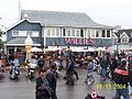
Willie's Restaurant in Port Dover on Friday, August 13, 2004.
-
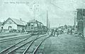
Union Station in Port Dover, circa the late-1930s.


