Communities in Norfolk County, Ontario facts for kids
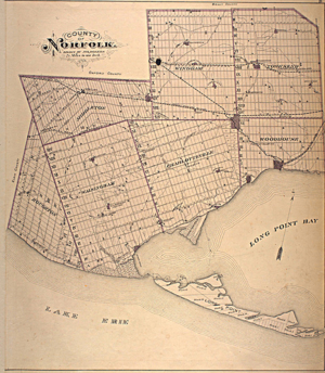
Norfolk County in the Canadian province of Ontario is home to many different communities. Its four main towns are Simcoe, Port Dover, Delhi, and Waterford. In 2016, about 64,044 people lived in the County. Simcoe is the largest community, with 13,922 residents.
In the late 1900s, Norfolk County joined with Haldimand County. But in 2000, they separated, and this area became known as The Town of the County of Norfolk.
Contents
Exploring Norfolk County's Communities
Communities from A to B
Andy's Corners
Andy's Corners (42°45′47″N 80°35′39″W / 42.763146°N 80.594158°W) is a small community. You can find it between Wyecombe and Carholme in Norfolk County.
Atherton
Atherton (42°49′23″N 80°26′49″W / 42.82298°N 80.446959°W) is a tiny village in Norfolk County. It is located between Gilbertville and Simcoe. Fewer than 100 people live here, and there are no sidewalks. You can find this community along Highway 3 and Lynedoch Road.
Bill's Corners
Bill's Corners (42°48′48″N 80°22′29″W / 42.813222°N 80.374775°W) is a small village in Norfolk County. It sits between Green's Corners and Hillcrest. The town of Simcoe is the closest larger town to the east.
A famous person who once lived here is Dwayne Roloson. He played as a goalie for six different teams in the National Hockey League (NHL). After retiring, Roloson became a goaltending coach for the Anaheim Ducks organization.
Blayney
Blayney is a village in Norfolk County. It is located between Pine Grove and Green's Corners. This community was established before 1920. It is now considered one of Norfolk County's "lost hamlets." It used to have its own post office and general store.
Rick Danko, a musician and founding member of the famous group The Band, grew up near here. There is a special plaque dedicated to him near his childhood home. He started playing the banjo when he was very young.
Bloomsburg
Bloomsburg (42°53′07″N 80°18′04″W / 42.885272°N 80.301218°W) is a village in Norfolk County. You can find it on the old Highway 24, just north of Simcoe. Bloomsburg is home to Bloomsburg Public School. This school teaches students from kindergarten all the way to eighth grade. The community mainly focuses on farming, and there are no shops or businesses here.
Booth's Harbour
Booth's Harbour is a community in Norfolk County. It has a historic harbor named after an early settler called Booth. The village was founded in the 1800s. Booth's Harbour is close to Lake Erie, right across the bay from Long Point. In summer, people enjoy fishing, boating, swimming, and exploring the harbor.
Boston
Boston is a community (42°59′27″N 80°16′13″W / 42.990711°N 80.270147°W) in Norfolk County. Farming is the main activity here, and there are not many shops. It is located northeast of Simcoe. Boston also has a school, Boston Public School, for students from kindergarten to eighth grade.
Communities from C to D
Clear Creek
Clear Creek (42°34′56″N 80°35′29″W / 42.582095°N 80.591326°W) is a village in southwestern Norfolk County. About 70 people live here in 140 houses. Some houses have been left empty due to concerns about wind turbines nearby. People have lived in this community since at least 1901. Some Canadian soldiers from the First World War grew up here.
There are no sidewalks for walking safely. Wind turbines were installed near Clear Creek in November 2008. Norfolk County later decided not to allow new wind turbines. Many leaders in Norfolk County want the area to be a major farming center for Southern Ontario. The closest high school is Valley Heights Secondary School.
Courtland
Courtland (42°50′26″N 80°37′58″W / 42.840605°N 80.632782°W) is a village in Norfolk County. It is on Highway 3 between Delhi and Tillsonburg. This community was once called Middleton. The first settler, Lot Tisdale, arrived in 1823. As of 2009, 917 people live here. There is also a large organic herb farm in the area.
Sidewalks are only on the main streets. Walking through Courtland is easy, but pedestrians should be careful of traffic. The village is flat and about 5 kilometers long. Good activities include hiking, running, and walking. Using ATVs, motorcycles, and bicycles is not recommended for safety. Courtland is also easy to get around for people using wheelchairs.
Courtland has a variety store, an antique shop, and a bakery that has been open since 1939. There is also a family restaurant and a flower shop. Businesses like Courtland Vinyl Windows and Gopher Dunes are well-known here. A golf course used to be in Courtland, but it closed in 2003 due to economic challenges.
Delhi
Delhi (pronounced DEL-High) is located where Highway 59 and Highway 3 meet. It is known as the "Heart of Tobacco Country."
Frederick Sovereign founded the settlement around 1812. The area was full of trees and became important for lumber. The village was first called Sovereign's Corners. Later, it was named Fredericksburg. In 1856, the post office opened and it became Delhi. Sovereign was a tavern owner and also made tobacco. He gave land for the Baptist church.
By 1869, Delhi had 300 people. It had factories and a lumber mill. The railway arrived in the 1870s, which helped businesses. The Delhi Canning Company, started in 1878, shipped canned local food across Canada.
Until 2001, Delhi was part of the Township of Delhi. In 2001, the population of the former Township of Delhi was 16,365. Growing tobacco was a big part of Delhi's farming history. The town has a tobacco museum to remember this past. Local farms often hire seasonal workers who come from other countries.
North Creek was once an important place for fish to lay eggs. But a dam was built in 1965.
In 2016, most people in Delhi spoke English and were born in Canada. There were more females than males. Most people were of working age. Delhi's population is expected to grow to about 5,215 people by 2056.
Dog's Nest
Dog's Nest is a community northeast of Port Dover along Highway 6. Its sign has been stolen three times. Now, a non-profit group called "DogsNest 1851" is working to bring the sign back. They sell items like t-shirts and hats to raise money. All the money goes towards the sign and helping the local area.
Communities from F to G
Fishers Glen
Fishers Glen is a fishing community. It is south of Simcoe and southwest of Port Ryerse. It is part of Norfolk County. Locals know Fishers Glen as one of the best places to fish in Lake Erie during the summer.
Frogmore
Frogmore (42°41′08″N 80°39′31″W / 42.685464°N 80.658703°W) is a village located at the crossing of Norfolk County Roads 45 and 28. It is northwest of Valley Heights Secondary School. Farming is the main activity here, and there are no businesses. It is one of the westernmost communities in Norfolk County.
This community has many German and Mexican Mennonite residents. Only a few wind turbines are in the area. No more can be built because of a county-wide ban on wind turbines passed in 2013. This community is protected from big city development because it is far from major towns like Simcoe and Delhi.
Gilbertville
Gilbertville (42°49′26″N 80°28′55″W / 42.823925°N 80.481806°W) is a village in Norfolk County. It is located between Pine Grove and Delhi. The local economy relies on farming, producing vegetables like potatoes, onions, and asparagus. Gilbertville has a tractor shop and an auto repair shop. There is a conservation park to the west.
Glenshee
Glenshee (42°46′04″N 80°29′01″W / 42.767809°N 80.483522°W) is a village west of Pinegrove in Norfolk County. It is mostly farmland and homes. Besides farms, there is a machine shop for local residents. Fewer than 20 people live here. The closest shops are in Tillsonburg and Delhi.
Green's Corners
Green's Corners is a village in Norfolk County. It is west of Simcoe, north of Walsh, and east of Pine Grove. Fewer than 50 people live in Green's Corners. Besides homes and farms, there are some businesses. These include a bakery, a bed and breakfast, a car garage, and a Christmas tree store. This village was also the hometown of the musician, Rick Danko of The Band.
Communities from H to J
Halfway House Corner
Halfway House Corner is a village in Norfolk County. It is south of Simcoe and northwest of Port Dover. The "Halfway House" was an inn located exactly halfway between Port Dover and Simcoe. Ontario Highway 24 is the main road. Businesses here include a bait shop and a recording studio.
Hillcrest
Hillcrest (42°49′50″N 80°20′11″W / 42.830471°N 80.336494°W) is a village in Norfolk County. It is between Bill's Corners and the town of Simcoe. There is a soccer field here. The Simcoe Lions Club gave $15,000 to this field in 2013. Adult soccer leagues sometimes use this field.
Houghton
Houghton was once a township in Norfolk County. Its main village was Fairground. It is in the southwest of Norfolk. Fairground is a small community where the Norfolk County Fair and Horse Show used to take place a long time ago.
This was where people went to the fair and farmers showed their best crops. The community of Fairground is next to Bayham in Elgin County to the west. Its southern border is the Lake Erie shoreline.
Jacksonburg
Jacksonburg (42°35′24″N 80°37′52″W / 42.590°N 80.631°W) is a small community in Norfolk County.
Communities from L to N
Langton
Langton (42°44′31″N 80°34′40″W / 42.74197°N 80.577679°W) is a small town in Norfolk County. It was once known as Boughner's Corner.
You can reach Langton by taking Ontario Provincial Highway 59 south from Delhi or Tillsonburg. If you are on Ontario Provincial Highway 3 heading east, you can turn south.
Langton used to have two banks. One bank closed in 2016 because more people use online banking. Langton was important for tobacco farmers in the 1900s.
Sidewalks are only on the main street. Walking in this town is easy. The town is about 5 kilometers long. Langton has beautiful rural and flat scenery. Streets can be busy, especially on weekdays. You can enjoy hiking, walking, running, and cycling here.
La Salette
La Salette is a village north of Delhi in Norfolk County. It is southwest of Brantford and northwest of Simcoe. Farming is the main activity, and there are very few shops. Most houses in La Salette are over 100 years old. Fewer than 100 people live here.
Long Point
Long Point is a long strip of sand and a medium-sized village on the north shore of Lake Erie. It is part of Norfolk County.
It is about 40 kilometers (25 miles) long and about one kilometer (0.6 miles) wide at its widest point. Lake Erie is to the south of Long Point. The waters to the north are called Long Point Bay. Some towns along the bay's north shore include Port Rowan, Turkey Point, and Port Dover.
Hunting was important after the Long Point Company bought the Point in 1866. Long Point Provincial Park was created in May 1921. By 1929, a new road connected it to the mainland.
Lynedoch
Lynedoch (42°48′06″N 80°30′35″W / 42.801573°N 80.509701°W) is a village in Norfolk County. It was named after Baron Lynedoch, who served in the Napoleonic Wars.
In the 1800s, this village had a post office, a school, shops, and churches. A church in the area has been restored. It is now used for outdoor weddings and private events.
Dennis' Horseradish is made a short distance east of the village.
Nixon
Nixon is a village in Norfolk County. It is mostly homes. There is an airfield, some farms, and one office building for a farming business. This building is where Nixon Public School used to be. Nixon is east of Delhi, northwest of Simcoe, and northeast of Pinegrove.
There are plans for a small brewery to open here. It will make beers and wines like those found in Belgium and the Netherlands. This brewery will help the economy of Norfolk County. This community is the westernmost one to get water from the Lynn River. The Lynn River flows into Lake Erie.
Normandale
Normandale (42°42′39″N 80°18′41″W / 42.710822°N 80.311346°W) is a charming fishing town in southwestern Norfolk County. It is famous for its perch and black bass fish. This settlement was part of Charlotteville. Fort Norfolk was built here in 1813 for 300 soldiers. A large iron factory, the Normandale Furnace and Ironworks, was built in 1817. It made farm tools, stoves, kettles, pots, and pans. It closed around 1847 or 1850.
Communities from P to R
Pinegrove
Before the late 1970s, much of Pine Grove was farmland owned by the Adcock family. After the family leader passed away around 1978, the land was divided. Then, the first building boom happened in Pine Grove. Most of Pine Grove was built by the mid-1980s. In the 1980s, children needing special education went to Nixon Public School and North Public School. These schools are no longer open since 2007.
Port Dover
In 1670, French explorers became the first Europeans to spend winter at what is now Port Dover. They built a hut and chapel near the Lynn River. In 1670, they put up a cross, claiming the area for the King of France.
By 1794, the first settlers, a group of United Empire Loyalists, started a village called Dover Mills. It was named after the English port of Dover. During the War of 1812, American troops burned the village down.
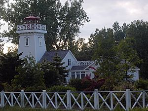
New buildings were put up closer to the Lynn River, where a harbor had been used since the early 1800s. In 1835, a merchant named Israel Wood Powell planned the village of Port Dover. By 1842, the village was growing with almost 400 people. The harbor, lighthouse, and a bridge were finished. There was also a school, mills, and a church. In 1877, Port Dover was a large village with 1,100 residents. It had a railway and a bigger harbor. Businesses included a factory, many stores, a newspaper, and a busy school. Port Dover became an official village in 1879.
Port Rowan
Port Rowan (42°37′26″N 80°27′01″W / 42.623918°N 80.45022°W) hosts an annual Bayfest every Labour Day. It used to be called "Tomato Fest." Local activities include fishing and boating in the Long Point Inner Bay. Bird Studies Canada is based in Port Rowan.
In 1845, Port Rowan was very small, with only 50 people. But it had a store, a tavern, a post office, and a customs officer for shipping. Lumber became important, and the population grew to 100 by 1845 and 200 by 1850.
By 1877, Port Rowan had about 1,000 residents. Many lived in beautiful homes overlooking the lake. It was a successful business and industry center. Fishing also started and continued through the 1900s. The village had three churches and several halls.
Just outside of town is the famous Backus Mill. Every year, there is a re-enactment of the War of 1812 here. This mill was built by John Backhouse in the 1790s and used water power.
Port Ryerse
Port Ryerse (42°45′35″N 80°15′33″W / 42.759743°N 80.259247°W) is a fishing village in Norfolk County. It is southwest of Port Dover. People from Southwestern Ontario rent cottages and fish here in the summer. The village was founded by Lieut-Colonel Samuel Ryerse. His harbor was important for shipping goods from Norfolk County across the lake.
Samuel Ryerse was a United Empire Loyalist who fought with the British. He came to Upper Canada in 1794 and received a lot of land. He built a mill, and a settlement grew around it.
American troops burned the mill in 1814 during the War of 1812. Later, two new mills were built in the same spot, but both also burned down. A brick schoolhouse was built in 1871.
Rattlesnake Harbour
Rattlesnake Harbour (42°52′45″N 80°24′42″W / 42.879172°N 80.411596°W) is a village in Norfolk County. It is north of Nixon. Despite the name, there is no harbor here. Farming is the main activity, not fishing. You might find rattlesnakes in the wild areas nearby, which is how it got its name.
Renton
Renton (42°51′34″N 80°13′13″W / 42.859482°N 80.22028°W) is a village in Norfolk County. It is between Simcoe and Jarvis in Haldimand County. There used to be a diner for truck drivers, but it burned down in 2010. There is a golf course nearby. Farming is the main activity. The number of people living here has stayed the same for 20 years.
Rhineland
Rhineland is a village in Norfolk County. Farming is the main activity. There are no shops, but the village has a church and rural homes. While tobacco used to be the main crop, farmers are now trying to grow lavender. This program started in 2003 to help the area grow different types of crops.
Rockford
Rockford (42°55′00″N 80°09′59″W / 42.9168°N 80.1664°W) is a village in Norfolk County. It is located between Waterford and Hagersville. It used to have a church, a general store, and a baseball team. Now, it is mostly farms and a few houses.
Communities from S to W
Silver Hill
Silver Hill is a village southwest of Pine Grove and southeast of Tillsonburg. Farming is the main activity. There is also a car repair shop and a neighborhood with houses and farms. Fewer than 100 people live in Silver Hill. To the south are Turkey Point and Lake Erie. Students here go to Walsh Public School for elementary grades and Valley Heights Secondary School for high school.
Simcoe
Simcoe is the main town of Norfolk County. It has about 16,000 people, making it Norfolk's largest community. Simcoe is located where Highway 3 and Highway 24 meet. It is south of Brantford, Ontario and can be reached from Hamilton by Highway 6.
lieutenant governor John Graves Simcoe founded Simcoe in 1795. At first, there were two separate areas: Birdtown and the Queensway. The post office opened in 1829 and was called Simcoe. In 1837, the village became the government center for the Talbot District.
In 1846, Simcoe was far from major roads. A stone courthouse and jail had been built. There were three churches and a weekly newspaper for the 1,400 people. There were also mills, a brewery, a factory, stores, and taverns.
In 1850, Simcoe had about 1,600 people and became the County seat of Norfolk County. Simcoe became an official town in 1878. It had its own town council and mayor until 2000. In 2001, Simcoe became Ward 5 of Norfolk County.
The town hosts the Lynn River Music and Arts Festival, the Norfolk County Fair and Horse Show, and a Christmas Panorama of Lights. As of 2019, Crystal Lake and Wellington Park were great places for bird watching. Over 83 bird species have been seen there.
St. Williams
St. Williams (42°40′02″N 80°24′55″W / 42.667354°N 80.415201°W) is a small village and fishing community in Norfolk County. It is about 30 minutes south of Pinegrove. St. Williams is also about 30 minutes from both Simcoe and Tillsonburg. It has about 400 people.
Teeterville
Teeterville (42°56′44″N 80°26′38″W / 42.94568°N 80.443869°W) is a village southwest of Vanessa. The main attraction here is the Teeterville Pioneer Museum. Farming is the main activity, and there are very few shops. There is also a public elementary school in the village.
Turkey Point
Turkey Point (42°40′52″N 80°19′56″W / 42.681047°N 80.332289°W) is a village in what is now Norfolk County. It is on Long Point Bay, south of Highway 24. The village is also home to MacDonald Turkey Point Marina.
John Graves Simcoe visited this area in 1795 and suggested a settlement be built. People started settling soon after. By 1800, law courts were held here.
Vittoria
Vittoria (42°45′46″N 80°19′23″W / 42.762705°N 80.322933°W) is a small village east of Walsh and southwest of Simcoe in Norfolk County. Today, it is known as one of Norfolk County's most historic communities. It has a fire station, a community hall, a town hall, and three active churches. Built in the early to mid-1800s, it was an important center. It was the capital of the London District from 1815 to 1825.
The Catherwood and the Kiln is a popular pizza restaurant. They also serve subs, panzerottis, and salads.
Vittoria Baptist Cemetery is on Charlotteville Road. It is a burial ground for United Empire Loyalists and has the remains of at least 532 people. This cemetery has been here since 1804. This settlement was the birthplace of Egerton Ryerson (in 1803). He was a Methodist minister. From 1844 to 1876, he was in charge of education for Upper Canada. He helped create Upper Canada's education system.
Walsh
Walsh, once called "Charlotteville Centre," is a medium-sized village in Norfolk County. It is home to Walsh Public School and St. Michael's Catholic Elementary School.
Since Walsh Public School is a rural school, farming is the main way most local families earn money. One or both parents usually work in jobs related to farming. Students at Walsh Public School are good at reading and writing. The annual Donnybrook Fair is held here in mid-September. It attracts kids and adults from the area.
The fair has been held since 1857 and gets bigger and better each year. Children who go to school nearby can enter their artwork, crafts, and farming-related items. They are usually between 5 and 13 years old. Homeschooled children can also enter. In 2011, local students won $1346 in cash prizes. This encourages children to save for higher education. It also helps them be creative and work hard. The Donnybrook Fair also has a demolition derby. Fundraising for the fair includes a Victoria Day brunch, a spring barbecue, and raffles.
Walsingham
Walsingham is a village in Norfolk County. It is south of Valley Heights Secondary School. The land near here was bought from the Mississauga First Nation. Some families settled here by 1791. Others, including Loyalists from the American Revolution, arrived later. The area had many trees and was important for the lumber industry until about 1878.
The farms and mills here were badly damaged in 1814 during the War of 1812. Everything was rebuilt, and the community was doing well by 1825.
Waterford
Waterford is located on the old Canada Southern Railroad line. This line used to go between Buffalo, New York and Detroit, Michigan. An electric railroad once operated in Waterford. The fare from Galt to Waterford was $1.05.
This community was founded in 1794. It started as a saw and grist mill community by Paul Averill in 1800. It was called Sayles' Mills, Sovereign's Mills, and Lodersville. The name changed to Waterford when a post office opened around 1826. Waterford became the main marketplace in northern Norfolk County. The village became an official town in 1878 when its population reached 1100 people.
In the early 1800s, this area was important for lumber and had many successful farms. The first settler was Job Slaght, who built the first mill. James L. Green owned much of the village and built a factory that made farm tools. The railway arrived in 1871, helping the town grow.
Wilsonville
Wilsonville (42°59′46″N 80°19′04″W / 42.99611°N 80.317869°W) is a village in Norfolk County. It is north of Waterford. It is considered the northernmost community in the Ontario tobacco farming area. Farming is the main activity. The homes here also serve as a place where people live and commute to Waterford for work. Children from this community go to Boston Public School or St. Bernard's of Clairvaux School for elementary grades. Then they go to Waterford District High School or Holy Trinity Catholic High School in Simcoe.
Wyecombe
Wyecombe (42°46′45″N 80°33′19″W / 42.779086°N 80.555191°W) is a small village. It is located at the intersection of East Quarter Line Road and County Road 21. Wyecombe has a quiet neighborhood with about 25 houses and a local car repair shop. The closest elementary schools are Langton Public School or Sacred Heart. The closest high school is Valley Heights Secondary School.
 | James Van Der Zee |
 | Alma Thomas |
 | Ellis Wilson |
 | Margaret Taylor-Burroughs |


