
Dover facts for kids
Quick facts for kids Dover |
|
|---|---|
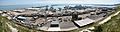
 Aerial view of Dover Harbour |
|

Dover
|
|
| Population | 31,022 (2011 Census) |
| OS grid reference | TR315415 |
| • London | 77.8 miles (125.2 km) |
| Civil parish |
|
| District |
|
| Shire county | |
| Region | |
| Country | England |
| Sovereign state | United Kingdom |
| Post town | DOVER |
| Postcode district | CT16, CT17 |
| Dialling code | 01304 |
| Police | Kent |
| Fire | Kent |
| Ambulance | South East Coast |
| EU Parliament | South East England |
| UK Parliament |
|
| Councillors |
|
Dover (/ˈdoʊvər/ DOH-vər) is a town and a very important ferry port in Kent, England. It's right across the English Channel from France, at the narrowest point, which is only about 33 kilometers (20 miles) wide! Dover is located south-east of Canterbury and east of Maidstone. It's the main town of the Dover District and home to the busy Port of Dover.
People have been coming and going from this area for thousands of years. The town's name comes from the River Dour that flows through it.
Recently, Dover has seen many exciting changes! It now has a fast train link to London, new shops, a beautiful beachfront, and a brand new pier and marina. These improvements are part of a big investment to make Dover even better.
Many people in Dover work at the busy Port of Dover or in tourism, thanks to famous places like the White Cliffs of Dover. Over 368,000 tourists visited Dover Castle in 2019! Dover is known as a 'Large-Port Town' because of all the ships that come and go.
Contents
- Discovering Dover's Past
- Dover's Location and Weather
- People of Dover
- Dover's Economy
- Amazing Places to See in Dover
- Getting Around Dover
- RNLI Lifeboat Station
- Schools in Dover
- Public Services
- Local Media
- Culture and Entertainment
- Twin Towns
- Sports and Activities
- Famous People from Dover
- Dover in Books and Songs
- Images for kids
- See also
Discovering Dover's Past
.JPG)
.jpg)
Dover's history is very important because it's so close to France. Archaeologists have found signs of Stone Age people living here. By the Bronze Age, people were already using the sea a lot.
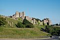
When the Romans arrived, Dover became a key part of their travel network. It was called Portus Dubris, a strong port with forts and lighthouses to guide ships. You can still see one of the best-preserved Roman villas in Britain here.
Dover was also a very important town in the Domesday Book, a famous survey from 1086. It played a big role in defending Britain, especially against the French during the Napoleonic Wars and against Germany in the Second World War. In medieval times, it was one of the important Cinque Ports.
Dover's Location and Weather

Dover is located in the very south-east corner of Britain, between Deal and Folkestone. The closest point to Europe, Cap Gris Nez in France, is only about 34 kilometers (21 miles) away across the Strait of Dover. This close distance means Dover has strong connections with France.
The town first grew in the valley of the River Dour. This was a great spot for a port because it was protected from strong winds. Over time, the river mouth started to fill with sand, so the town had to build artificial walls to keep the port open. These walls have been expanded, and now the port is mostly on land that was created from the sea.
The high land on both sides of the valley, known as the Dover Western Heights and the area where Dover Castle stands, was used to protect the town from invaders. Dover has slowly grown up the river valley, taking in several old villages. It can't grow much along the coast because of the steep cliffs right by the sea. The railway line runs along the bottom of these cliffs.
Dover has an oceanic climate, which means it has mild temperatures all year round and a bit of rain each month. The hottest temperature ever recorded was 31°C (88°F), and the coldest was -8°C (18°F). Usually, temperatures stay between 3°C (37°F) and 21.1°C (70°F).
| Climate data for Dover Harbour (Beach), elevation: 0m (1981-2010) | |||||||||||||
|---|---|---|---|---|---|---|---|---|---|---|---|---|---|
| Month | Jan | Feb | Mar | Apr | May | Jun | Jul | Aug | Sep | Oct | Nov | Dec | Year |
| Record high °C (°F) | 16 (61) |
13 (55) |
18 (64) |
23 (73) |
26 (79) |
28 (82) |
31 (88) |
31 (88) |
25 (77) |
24 (75) |
16 (61) |
14 (57) |
31 (88) |
| Mean daily maximum °C (°F) | 7.8 (46.0) |
7.8 (46.0) |
10.1 (50.2) |
11.9 (53.4) |
15.7 (60.3) |
18.2 (64.8) |
20.7 (69.3) |
21.1 (70.0) |
18.8 (65.8) |
15.4 (59.7) |
11.4 (52.5) |
8.4 (47.1) |
14.0 (57.2) |
| Daily mean °C (°F) | 5.6 (42.1) |
5.4 (41.7) |
7.4 (45.3) |
9.1 (48.4) |
12.5 (54.5) |
15.2 (59.4) |
17.5 (63.5) |
17.8 (64.0) |
15.8 (60.4) |
12.6 (54.7) |
8.9 (48.0) |
6.2 (43.2) |
11.2 (52.2) |
| Mean daily minimum °C (°F) | 3.3 (37.9) |
3.0 (37.4) |
4.6 (40.3) |
6.3 (43.3) |
9.3 (48.7) |
12.1 (53.8) |
14.3 (57.7) |
14.5 (58.1) |
12.8 (55.0) |
9.8 (49.6) |
6.4 (43.5) |
4.0 (39.2) |
8.4 (47.1) |
| Record low °C (°F) | −5 (23) |
−8 (18) |
−4 (25) |
−1 (30) |
1 (34) |
5 (41) |
6 (43) |
8 (46) |
6 (43) |
1 (34) |
−3 (27) |
−6 (21) |
−8 (18) |
| Average precipitation mm (inches) | 74.9 (2.95) |
59.4 (2.34) |
51.5 (2.03) |
60.0 (2.36) |
50.9 (2.00) |
56.2 (2.21) |
49.5 (1.95) |
57.6 (2.27) |
67.4 (2.65) |
101.9 (4.01) |
102.2 (4.02) |
85.3 (3.36) |
816.8 (32.16) |
| Average precipitation days (≥ 1.0 mm) | 12.3 | 10.6 | 10.6 | 10.5 | 8.1 | 8.2 | 8.2 | 8.0 | 10.2 | 11.6 | 12.6 | 12.7 | 123.5 |
| Average relative humidity (%) | 88 | 86 | 84 | 81 | 83 | 84 | 84 | 82 | 82 | 84 | 87 | 88 | 84 |
| Mean monthly sunshine hours | 66.0 | 83.4 | 117.5 | 185.2 | 214.7 | 213.3 | 221.6 | 223.4 | 159.4 | 126.0 | 76.7 | 55.8 | 1,743 |
| Source 1: Met Office | |||||||||||||
| Source 2: weather2 | |||||||||||||
People of Dover
In 1800, before Britain's first national count of people, Dover had almost 10,000 residents. By 2001, the town of Dover had 28,156 people. The whole urban area of Dover had 39,078 people.
As Dover grew, many older villages became part of the town. These include Buckland and Charlton, and areas like Maxton, River, Kearsney, Temple Ewell, and Whitfield.
Dover's Economy
Shopping in Dover
Dover's main shopping areas are High Street, Biggin Street, Market Square, Cannon Street, Pencester Road, and Castle Street. There's also the Castleton Retail Park. A new shopping and entertainment area called St James' Retail and Leisure Park opened in 2018. It has shops, restaurants, a hotel, and a cinema.
Busy Port and Shipping
.JPG)
The Dover Harbour Board manages the Port of Dover. The English Channel here is the busiest shipping lane in the world! Ferries crossing to Europe have to navigate through many other ships. There's a special system called the Dover Strait Traffic Separation Scheme that helps ships stay in their own lanes. This system is managed by the Channel Navigation Information Service in Dover. They also help with sea search and rescue missions.
The Port of Dover is also used by large cruise ships. One passenger terminal is in the old Dover Marine railway station building. A second, newer terminal is further out on the pier.
Here are some of the ferry lines that use the port:
- To Calais, France: P&O Ferries, DFDS Seaways, and Irish Ferries.
- To Dunkirk, France: DFDS Seaways.
Some ferry services have stopped in recent years, like those to Boulogne and Zeebrugge.
Amazing Places to See in Dover

- Blériot Memorial: This marks the exact spot where Louis Blériot landed in 1909 after the first flight across the English Channel.
- Dover Castle: A huge, historic castle with amazing views.
- White Cliffs of Dover: Famous white chalk cliffs that are a symbol of England.
- Dover Western Heights: Old forts and tunnels built into the hills.
- Dover Museum: Learn about Dover's history, from ancient times to today.
- Dover Marina: A modern area for boats and walking.
- Dover Pier: A new pier for walking and enjoying the sea.
- Roman Painted House Museum: See the remains of a Roman house with colorful wall paintings.
- Maison Dieu, Dover: A historic building that is now the Town Hall.
- Samphire Hoe: A nature reserve created from the Channel Tunnel's dug-out chalk.
- South Foreland Lighthouse: A historic lighthouse on the cliffs.
- Pines Garden: Beautiful gardens with a focus on nature.
- St Edmund's Chapel: A small, ancient chapel.
- St Mary's Church: A historic church in the town.
- St James' Church: Preserved as a "tidy ruin" to show its history.
- St Paul's Church: Another important church in Dover.
-
The castle from the north
-
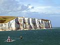
White Cliffs seen from the Strait of Dover
-
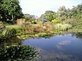
The Pines Garden
-
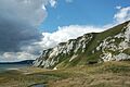
Samphire Hoe beneath the White Cliffs of Dover


Getting Around Dover
Roads
Dover's main road, the A2, connects the town to Canterbury. This road follows old routes, including a Roman road. In the past, it took a whole day to travel from Dover to London by stagecoach!
Other main roads include the A20 to Folkestone and the A258 through Deal to Sandwich.
Trains
Trains arrived in Dover from two directions. The South Eastern Railway connected to Folkestone in 1844. The London, Chatham & Dover Railway opened its line from Canterbury in 1861.
Today, Southeastern trains run from Dover Priory to London stations like Charing Cross, Victoria, or St Pancras International. You can also take trains to Ramsgate or Sandwich in Kent. Thanks to the high-speed service to St Pancras International, you can now get to London from Dover in just 55 minutes!
Dover also had a tram system that ran from 1897 to 1936.

Walking Paths
Dover has two long distance footpaths: the Saxon Shore Way and the North Downs Way. You can walk from the town centre to the National Trust White Cliffs. From there, paths lead to South Foreland Lighthouse and St Margarets Bay along the cliff top. On a clear day, you can even see France!
Cycling Routes
Two National Cycle Network routes start in Dover. Route one goes from Dover to Canterbury. This route connects with National Cycle Route 2 and other regional routes. It passes three castles, including Dover Castle, Walmer Castle, and Deal Castle.
Dover town centre is friendly for cyclists. There are special cycle lanes along the seafront and routes through the pedestrian areas of the High Street.
Ferry Services
The Port of Dover is about a 20-minute walk from Dover Priory railway station. You can take ferries from Dover to Calais (with DFDS, P&O, and Irish Ferries) and to Dunkerque (with DFDS). The trip to Dunkirk takes about two hours. Dunkirk is a good starting point if you're traveling by road to countries like Belgium, the Netherlands, or Germany.
Bus Services
Stagecoach in East Kent provides local bus services in Dover. Dover is part of the Stagecoach Diamond network, with links to Canterbury and Deal. Buses also serve the Western Docks at the Port of Dover. Dover is the start of The Wave network to New Romney via Folkestone, Hythe, and Dymchurch. There are also services to Lydd and Sandwich.
National Express runs coaches from Dover to other towns in Kent, like Canterbury, Folkestone, and Maidstone. They also go to London, including Victoria Coach Station.
RNLI Lifeboat Station
The Dover lifeboat is a Severn class lifeboat, which is the biggest in the RNLI fleet. It's based at the crosswall quay in Dover Harbour. The RNLI covers all of Great Britain and the Dover lifeboat often helps with emergencies in the Channel. The Severn class lifeboat is built to stay afloat and can even right itself if it capsizes.
Schools in Dover
Dover has several secondary schools for students aged 11-18.
Independent Schools
- Dover College
Dover College is a mixed independent school. It was started in 1871 by local business people.
Selective Schools
There are two single-sex grammar schools and a mixed military school in Dover. To get into these schools, students usually need to pass a special test.
- Dover Grammar School for Boys (DGSB)
- Dover Grammar School for Girls (DGGS)
- Duke of York's Royal Military School: This is a special boarding school for children of people serving in the military.
Other Secondary Schools
Dover also has other mixed secondary schools, which are now called academies.
- Astor Secondary School
- St Edmund's Catholic School
- Dover Christ Church Academy: This school is located in Whitfield, a few miles north of Dover.
Technical College
Dover Technical College is part of the East Kent College (EKC) group, offering further education.
In addition to these, Dover has 16 primary schools and two special schools.
Public Services
Dover has one hospital, Buckland Hospital. In the past, there were other hospitals like the Royal Victoria Hospital.
Local Media
TV and Radio
Local news and TV shows for Dover come from BBC South East and ITV Meridian. You can get TV signals from the Dover TV transmitter.
Dover used to have TV studios for Southern Television, which made shows from 1958 to 1981.
Dover has a local radio station, KMFM Shepway and White Cliffs Country, on 106.8FM. You can also listen to county-wide stations like Heart South and BBC Radio Kent. DCR 104.9FM (Dover Community Radio) started broadcasting in May 2022. It offers local programs, music, and news for Dover.
Newspapers
Dover has two local newspapers: the Dover Express and the Dover Mercury.
Culture and Entertainment
Dover has three museums: the main Dover Museum, the Dover Transport Museum, and the Roman Painted House. There are two cinemas: the Silver Screen Cinema at the Dover Museum, and the Cineworld Cinema which opened in 2018.
The Discovery Centre has Dover's library, the Dover Museum, and the Silver Screen Cinema. It also has the Roundhouse Community Theatre and adult education facilities. The Charlton Shopping Centre has shops, a community hub, and the studios for Dover Community Radio. The White Cliffs Theatre is located at Astor College. There's also a community theatre at St Edmund's Catholic School.
Twin Towns
Dover is twinned with these towns:
- Calais, France
- Huber Heights, Ohio, United States
- Split, Croatia
- Dover, Christ Church, Barbados
Sports and Activities
The Dover District Leisure Centre opened in March 2019. It has facilities for many sports, including a swimming pool.
Dover has various sports clubs, including:
- Dover Athletic F.C.: A football club.
- Rugby, swimming, water polo, and netball clubs.
Dover Rowing Club is the oldest coastal rowing club in Britain. It has a long history and was once the best club on the south coast.
One famous event in Dover is swimming across the English Channel. You can also enjoy sea fishing from the beach, pier, or out at sea. The famous Dover sole fish is found in European waters. Dover is also a great place for watersports like paddle-boarding and kayaking.
Famous People from Dover
Dover in Books and Songs
In Literature
- M.R. James set part of his ghost story "Casting the Runes" (1911) in Dover's Lord Warden Hotel.
- Matthew Arnold wrote his 19th-century poem, Dover Beach, about Dover.
- Dover appears several times in A Tale of Two Cities by Charles Dickens.
- Russell Hoban called Dover "Do It Over" in his 1980 novel Riddley Walker.
In Songs
- " (There'll Be Bluebirds Over) The White Cliffs of Dover" by Vera Lynn, recorded in 1942.
- "Cliffs of Dover" is an instrumental rock song by Eric Johnson, released in 1990.
- "Clover Over Dover" by British band Blur is on their 1994 album Parklife.
- "Calais to Dover" by American band Bright Eyes is on their 2020 album Down in the Weeds, Where the World Once Was.
- "Dover Beach" by Baby Queen is on her 2021 album The Yearbook. She was inspired by Matthew Arnold's poem and filmed her music video at Samphire Hoe.
Images for kids
-
Dover Harbour, from the White Cliffs of Dover
See also
 In Spanish: Dover (Kent) para niños
