
A2 road (England) facts for kids
Quick facts for kids
|
|
|---|---|
 |
|

|
|
| Route information | |
| Length | 71.95 mi (115.79 km) |
| Major junctions | |
| North west end | Southwark 51°30′04″N 0°05′35″W / 51.5012°N 0.0931°W |
| South east end | Dover 51°07′35″N 1°19′38″E / 51.1263°N 1.3271°E |
| Location | |
| Primary destinations: |
Dartford, Rochester, Faversham, Canterbury |
| Road network | |
|
|

The A2 is a really important road in South East England. It connects London, the capital city, all the way to Dover on the coast. From Dover, you can even take a ferry across the English Channel to France! This road has a super long history. It follows paths that people like the Celts and the Romans used thousands of years ago.
Contents
What is the A2 Road?
The A2 is one of Britain's main roads. It's about 72 miles (116 km) (around 116 kilometers) long. It starts in Southwark, London, and stretches all the way to the port town of Dover in Kent. This road is a key route for travel and trade between London and mainland Europe.
A Road with Ancient Roots
Imagine a road that's been used for thousands of years! The A2 follows old paths that were important long before cars existed.
- Celtic Trails: The earliest people in Britain, the Celts, likely used these routes for moving around.
- Roman Roads: When the Romans came to Britain, they built amazing straight roads. The A2 follows parts of a famous Roman road called Watling Street. This Roman road connected London to three big Roman ports:
- Rutupiae (now called Richborough)
- Dubris (which is now Dover)
- Portus Lemanis (found in modern Lympne)
These ports were vital for the Romans to bring goods and soldiers into Britain.
How the A2 Got Its Name
The name "A2" was given to this road in the 1920s. This was when Britain started to officially number its main roads. Before that, it was just known by its historical names, like Watling Street.
Where Does the A2 Go?
The A2 passes through many interesting towns and areas.
- London: It starts in Southwark, a busy part of London.
- Dartford: The road goes near Dartford, which is famous for the Dartford Crossing over the River Thames.
- Rochester: It crosses the River Medway at Rochester, a city with a rich history and a famous castle.
- Faversham: The A2 continues through Faversham, a charming market town.
- Canterbury: It passes close to Canterbury, home to the famous Canterbury Cathedral.
- Dover: Finally, it reaches Dover, known for its white cliffs and busy port.
Images for kids
-
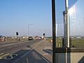
A2 across Blackheath.
-
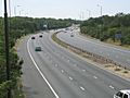
A2 at Leyton Cross
-
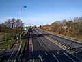
A2 road in Bexley
-
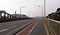
Looking west: the modern A2 crossing the River Medway at Rochester near the Roman and Celt crossings


