
Richborough Castle facts for kids
Quick facts for kids Richborough Castle |
|
|---|---|
| Rutupiæ | |
| Richborough, Kent in England | |

Richborough Roman Fort
|
|

Richborough Castle
|
|
| Coordinates | 51°17′38″N 1°19′55″E / 51.294°N 1.332°E |
| Grid reference | TR324602 |
| Type | Roman fort |
Richborough Castle holds the remains of an old Roman fort. It's also known as Richborough Fort or Richborough Roman Fort. You can find it in Richborough, near Sandwich, in Kent, United Kingdom.
The Romans built this site, which they called Rutupiae or Portus Ritupis, after they invaded Britain in AD 43. Because it was close to the mouth of the River Stour, Rutupiae became a very important Roman port in Britain. It was also the starting point for a famous Roman road called Watling Street.
At first, the Romans dug earth defenses here in the 1st century. This was probably a place to store supplies and a safe spot for their army to land. Over time, it grew into a busy town for people and trade. Later, around the year 277, it was turned into a strong military fort. This fort was likely built by a rebel leader named Carausius. Today, English Heritage looks after the site.
Contents
What's in a Name? The Meaning of Rutupiae
The exact meaning of the name Rutupiae is not fully clear. The first part might come from an old British Celtic word, *rutu-, which means "rust" or "mud."
Another name for the fort was Ritupiae. This name might come from the word *ritus, meaning "ford." A ford is a shallow place where you can cross a river. This could refer to a crossing point between what was then an island and the main land. The meaning of the -piae part of the name is still a mystery.
History of Richborough Castle
How the Romans Invaded Britain
Many historians believe that Richborough Castle was the place where the Roman army landed in 43 AD. This was when Emperor Claudius led the Roman invasion of Britain. Evidence for this idea includes ditches and defenses from the mid-1st century found at the site. Also, this location offered the shortest sea route across the English Channel.
These early ditches and defenses were probably built to protect the Roman landing spot and their supply base. However, the exact details of where the Romans landed are not fully known. So, the landing site is still something experts discuss.

Richborough as a Civilian Town
As the Roman army moved further north, Rutupiae grew into a large town for everyday people. It had temples, and even an amphitheater. An amphitheater is a round or oval open-air building used for shows and sports. You can still see a small hill where it once stood, about a five-minute walk from the main site.
The town also had a mansio. This was a building that changed over time. It started around 100 AD as a guest house for important visitors. Later, it became a bath house and an office building.
As a port, Richborough competed with Portus Dubris (modern Dover), which was about 15 miles south. However, Richborough was famous throughout the Roman Empire for its excellent oysters. Roman writers even mentioned them as being as good as oysters from Italy. The phrase "Rutupine shore" became a common way for Latin writers to refer to Britain.
The Grand Triumphal Arch
A huge quadrifrons triumphal arch was built right over Watling Street. This was the main road connecting Richborough to London. Its location and large size suggest it might have been built to celebrate the Roman conquest of Britain. This was after a Roman general named Agricola won a big battle called the Battle of Mons Graupius.
The arch was almost 25 meters (about 82 feet) tall. It had a beautiful front made of high-quality Italian granite. Since it stood between the port and the rest of the Roman province, passing through the arch meant you were officially entering Britannia (Britain).
Today, only the foundations and a mound of the Richborough arch can still be seen. The Romans themselves took it apart. They likely used its stones to build the later Saxon Shore fort on the same site.
The Saxon Shore Fort
.jpg)

In the late 3rd century, this large civilian town became a military base again. It was turned into a "Saxon Shore fort." These were a series of forts built by the Romans along the English and French coasts of the Channel. They were possibly built to defend against Saxon pirates who might invade.
Building the fort here is thought to have started in 277 AD and finished in 285 AD. This involved taking apart the triumphal arch and reusing its stones. Coins found at the site suggest this happened during the time of Carausius, who was a rebel emperor.
The fort covered about 5 acres and was surrounded by huge walls, forming an almost perfect square. The walls on the north and south sides were built differently. This suggests the north wall might have been built later than the south wall. In some places, the walls were over 25 feet (8 meters) high. They were made of small stones and double layers of tiles. The main entrance to the fort was in the west wall. These walls are still very tall and were built so well that they only recently needed repairs.
Inside the fort, most buildings were made of wood, but some were stone. There was a central rectangular stone building, likely the principia (the headquarters). Small stone bathhouses were also present at Richborough.
Early Church at Richborough
There is a mysterious structure at Richborough that experts believe was a font. A font is a basin used for baptisms in a church. Today, this structure is mostly destroyed. The hexagonal font found during digs suggests that baptisms might have happened in a church here. This church was probably built around the end of the 4th century or the beginning of the 5th century. It seems likely that this church was made of wood.

The Romans Leave Britain
As the Roman Empire began to decline, the Romans eventually left Richborough. After they left, the site was used by a Saxon religious community.
Discoveries Through Digging
In late 2008, archaeologists dug up a 90-meter section of the Roman wall. They found the original Roman coastline and the remains of a medieval dock. Finding the ancient beach helped them understand how the earthworks were built to defend about 700 meters of the coast. Today, the site is two and a half miles inland from the current coastline.
In 2020, English Heritage planned to explore the amphitheater. A historian named Paul Pattison said they wanted to find out "what did the amphitheater look like, how was it constructed and what happened after it fell out of use?"
Images for kids
-
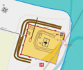
Richborough site plan showing the ancient shore line.
-
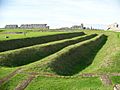
Early ditch defenses inside the later fort.
-
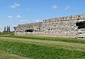
The fort's South Wall.
-
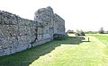
The fort's west wall.


See also
 In Spanish: Rutupiae para niños
