River Medway facts for kids
Quick facts for kids River Medway |
|
|---|---|

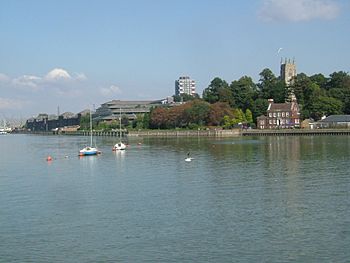
Medway at Gun Wharf, Chatham
|
|

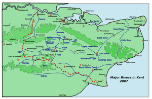
Rivers in Kent, showing the Medway
|
|
| Country | England |
| Region | South East England, West Sussex, Kent |
| District | Mid Sussex, Sevenoaks, Tonbridge and Malling, Medway and Maidstone |
| Physical characteristics | |
| Main source | Turners Hill, West Sussex 489 ft (149 m) 51°06′25″N 0°5′37″W / 51.10694°N 0.09361°W |
| River mouth | Thames Estuary Garrison Point, Sheerness, Kent 51°26′57″N 0°44′18″E / 51.44917°N 0.73833°E |
| Length | 70 mi (110 km) |
| Basin features | |
| Basin size | 930 sq mi (2,400 km2) |
| Tributaries |
|
| Designation | |
| Official name: Medway Estuary & Marshes | |
| Designated: | 15 December 1993 |
The River Medway is a long river in England. It flows for about 70 mi (110 km) (113 kilometers) from the High Weald area in Sussex, through the county of Kent, and finally into the Thames Estuary. After a place called Allington Lock, the river becomes tidal, meaning its water level goes up and down with the ocean tides.
Contents
What Rivers Join the Medway?
Many smaller rivers and streams flow into the River Medway. These are called its tributaries. They add more water to the Medway as it flows towards the sea.
Here are some of the main rivers that join the Medway:
- River Eden
- River Bourne (also known as the River Shode and River Busty)
- River Teise (which also has its own tributary, the River Bewl)
- River Beult
- Loose Stream
- River Len
For a long time, it was hard to travel by boat on the River Medway above the town of Maidstone. This changed in 1746 when improvements were made. Today, the Environment Agency is in charge of managing the river for boats and making sure it's safe to use.
Images for kids
-
The Medway flows through Tonbridge in many channels. The South Eastern Main Line crosses the Medway.
-
The Botany stream forms another channel in Tonbridge.
-
Tonbridge Castle, a motte-and-bailey castle from 1066.
-
The River Medway passes Tonbridge Castle and passes under Big Bridge.
-
Grain and Thamesport, from Horrid Hill, Gillingham.
-
The mouth of the Medway, looking from Grain to Sheerness.
See also
 In Spanish: Río Medway para niños
 | George Robert Carruthers |
 | Patricia Bath |
 | Jan Ernst Matzeliger |
 | Alexander Miles |


