Thames Estuary facts for kids
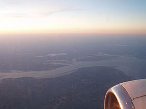
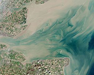
The Thames Estuary is a special place where the River Thames flows into the North Sea. It's located in the south-east of Great Britain. Think of it as the wide mouth of the river, where fresh river water mixes with salty sea water.
This area is super important for many reasons. It's a huge shipping route, meaning lots of big ships travel through it every year. These ships carry things like oil, containers, and other goods to major ports like the Port of London and the Medway Ports.
In the past, special boats called Thames sailing barges were used here. They were designed to sail in the shallow waters of the smaller ports. Today, the estuary is also home to some of the UK's biggest wind farms, which create clean electricity from the wind. One of these, the London Array, is one of the largest offshore wind farms in the world!
People have also thought about building a new airport in the estuary to help with air travel around London. This would be a big project, possibly on a man-made island.
Contents
What is the Thames Estuary?
The word "estuary" means a place where a river meets the sea. The Thames Estuary is a mix of fresh and salt water. The exact edges of the estuary can be described in different ways:
- The Sea Reach is a part of the river that feels like the sea. It starts near Canvey Island in Essex.
- The Yantlet Line is an imaginary line between two old stones, one in Chalkwell and one on the Isle of Grain.
- The Nore is a sandbank that marks another point.
- Some experts say the eastern edge stretches from North Foreland in Margate, Kent, all the way to Harwich in Essex. This is because the sandy areas that are typical of an estuary reach this far.
The water in the estuary moves a lot with the tides. It can rise and fall by about 4 metres and move quite fast, up to 2.6 knots (about 4.8 km/h).
The Wider Thames Estuary Area

When people talk about the Greater Thames Estuary, they mean the coast and the flat lands around the estuary. This area has lots of interesting natural features:
- Mudflats: These are muddy areas that are covered by water at high tide and exposed at low tide.
- Open beaches: Wide, flat beaches.
- Salt marshes: Grassy areas that are flooded by salty water from the sea. You can find the North Kent Marshes and the Essex Marshes here.
To protect the land from the sea, people have built walls called embankments. Behind these walls are areas of reclaimed land, often used for grazing animals. However, with sea levels rising, some of these areas might need to be flooded on purpose during very high tides to help protect the main defences.

There are also many smaller estuaries in Essex, like the Colne, Blackwater, and Crouch. Small towns along the coast often rely on fishing, building boats, and yachting. Many islands are part of this coastline, including the Isle of Sheppey, the Isle of Grain, and Mersea Island.
Some larger towns are located where higher land meets the coast, such as Clacton-on-Sea in Essex and Southend-on-Sea closer to the main estuary.
Saltiness of the Water
The River Thames changes a lot as it flows from London to the sea.
- Near Teddington, the river is mostly fresh water. This is where the tides stop affecting the river.
- Around Battersea, the water starts to become a little salty, a mix of fresh and sea water. This is called brackish water. Here, you'll find fish that can live in both fresh and slightly salty water, like flounder and European seabass.
- As you go further east towards Gravesend, the water becomes saltier and saltier. By the time you reach Gravesend, it's mostly salty like the North Sea. Here, you'll find fish that live in the sea.
The types of plants and tiny creatures living in the river also change as the water gets saltier.
Shipping Channels
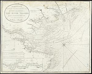
For big ships coming into London from the sea, there are main deep-water paths called channels. These include the Princes Channel, Queens Channel, and South Channel. There are also channels to the north, like the Kings Channel and the Swin, which smaller boats and barges used.
These channels are natural deep areas in the seabed. They are marked with special buoys and lights to guide ships safely. The channels are separated by slow-moving sandbanks, which have names like the East and West Barrows, the Nob, and the Long sands.
Smaller boats and leisure craft are expected to use channels that are best for their size. For example, if they are coming from the north, they might use the Middle Deep, Swin, and Warp channels. If they are coming from the south, they might use the Horse and Gore and Four Fathom Channels.
To cross the estuary, large ships often use Fisherman's Gat, while smaller vessels might use Foulger's Gat.
To help ships navigate safely, especially at night or in bad weather, the Thames Estuary has many lights, buoys, and other marks. These are like traffic lights and road signs for boats!
The buoys are coloured differently to show which side of the channel they are on. In this area, red buoys are on the left (port) side when you're going upstream, and green buoys are on the right (starboard) side.
Here are some of the main navigation marks you would see in the Thames Estuary, from west to east:
| Name of Navigational Mark | South of Channel (Right Side Going Out) | Channel Name | North of Channel (Left Side Going Out) | ||||
|---|---|---|---|---|---|---|---|
| Type | Light Signal | Location | Type | Light Signal | Location | ||
| Margaretness Point Light | Lighthouse | Group flashing (2) white 5s | 51°30.662′N 0°05.766′E / 51.511033°N 0.096100°E | Gallions Reach / Barking Reach | ̶ | ̶ | ̶ |
| Crossness Point Light | Lighthouse | Flashing white 5s | 51°30.920′N 0°07.990′E / 51.515333°N 0.133167°E | Barking Reach / Halfway Reach | ̶ | ̶ | ̶ |
| Crayfordness Point Light | Lighthouse | Flashing white 5s + fixed | 51°28.689′N 0°13.000′E / 51.478150°N 0.216667°E | Erith Rands / Long Reach | ̶ | ̶ | ̶ |
| Stone Ness Light | ̶ | ̶ | ̶ | Long Reach / St Clement's Reach | Lighthouse | Flashing green 2.5s | 51°27.9167′N 0°16.8231′E / 51.4652783°N 0.2803850°E |
| Broadness Point Light | Lighthouse | Occulting red 5s | 51°27.878′N 0°18.900′E / 51.464633°N 0.315000°E | St Clement's or Fiddler's Reach / Northfleet Hope | ̶ | ̶ | ̶ |
| Tilbury Warning Light | ̶ | ̶ | ̶ | Gravesend Reach | Warning light, vessels manoeuvring at Tilbury | Isophase 6s | 51°27.000′N 0°21.340′E / 51.450000°N 0.355667°E |
| Shornmead Light | Lighthouse | Group flashing (2) white, red 10s | 51°26.983′N 0°26.533′E / 51.449717°N 0.442217°E | Gravesend Reach / The Lower Hope | ̶ | ̶ | |
| Ovens | ̶ | ̶ | ̶ | The Lower Hope | Quick flashing green | 51°27.493′N 0°26.355′E / 51.458217°N 0.439250°E | |
| Haven Traffic Warning Lights | Warning light, vessels manoeuvring at Coryton | White | 51°27.90′N 0°30.10′E / 51.46500°N 0.50167°E | The Lower Hope / Sea Reach | Warning light, vessels manoeuvring at Coryton | White | 51°30.50′N 0°31.65′E / 51.50833°N 0.52750°E |
| London Gateway | ̶ | ̶ | ̶ | Sea Reach | Buoy | 51°30.30′N 0°28.20′E / 51.50500°N 0.47000°E | |
| Sea Reach No. 7 | Port buoy | Flashing Red 2.5s | 51°30.011′N 0°36.908′E / 51.500183°N 0.615133°E | The Yantlet Channel | Yellow pillar buoy | Flashing yellow 2.5s | 51°30.206′N 0°36.938′E / 51.503433°N 0.615633°E |
| Sea Reach No. 6 | Port buoy | Flashing red 5s | 51°29.932′N 0°39.839′E / 51.498867°N 0.663983°E | Starboard buoy | Flashing green 5s | 51°30.126′N 0°39.867′E / 51.502100°N 0.664450°E | |
| Sea Reach No. 5 | Port buoy | Very quick flashing red | 51°29.848′N 0°41.426′E / 51.497467°N 0.690433°E | Starboard buoy | Very quick flashing Green | 51°30.041′N 0°41.473′E / 51.500683°N 0.691217°E | |
| Sea Reach No. 4 | Port buoy | Group flashing (2) red 5s | 51°29.504′N 0°44.121′E / 51.491733°N 0.735350°E | Starboard buoy | Group flashing (2) green 5s | 51°29.694′N 0°44.193′E / 51.494900°N 0.736550°E | |
| Sea Reach No. 3 | Port buoy | Quick flashing red | 51°29.221′N 0°46.707′E / 51.487017°N 0.778450°E | Starboard buoy | Quick flashing green | 51°29.410′N 0°47.061′E / 51.490167°N 0.784350°E | |
| Sea Reach No. 2 | Port buoy | Flashing red 5s | 51°29.296′N 0°49.754′E / 51.488267°N 0.829233°E | Starboard buoy | Flashing green 5s | 51°29.493′N 0°49.726′E / 51.491550°N 0.828767°E | |
| Sea Reach No. 1 | Port buoy | Flashing red 2.5s | 51°29.368′N 0°52.445′E / 51.489467°N 0.874083°E | Yellow pillar buoy | Flashing yellow 2.5s | 51°29.586′N 0°52.710′E / 51.493100°N 0.878500°E | |
| West Oaze | ̶ | ̶ | ̶ | The Oaze Deep | Red & white buoy | Isophase 5s | 51°28.975′N 0°55.413′E / 51.482917°N 0.923550°E |
| Oaze Bank | ̶ | ̶ | ̶ | Starboard buoy | Quick flashing green | ||
| Oaze | Yellow pillar buoy | Group flashing (4) Yellow 10s | 51°28.977′N 0°56.917′E / 51.482950°N 0.948617°E | ̶ | ̶ | ̶ | |
| Argus | ̶ | ̶ | ̶ | Yellow pillar buoy yellow ‘X’ topmark | Flashing yellow 2.5s | 51°29.297′N 0°58.715′E / 51.488283°N 0.978583°E | |
| Oaze Deep | ̶ | ̶ | ̶ | Starboard buoy | Group flashing (2) green 5s | 51°30.000′N 1°0.000′E / 51.500000°N 1.000000°E | |
| Knob | Red & white buoy | Isophase 5s | ̶ | ̶ | ̶ | ||
| SE Mouse | ̶ | ̶ | ̶ | Starboard buoy | Quick flashing green | ||
| Knock John No. 7 | ̶ | ̶ | ̶ | The Knock John Channel | Starboard buoy | Group flashing (4) green 15s | 51°31.956′N 1°06.406′E / 51.532600°N 1.106767°E |
| Knock John No. 5 | ̶ | ̶ | ̶ | Starboard buoy | Group flashing (3) green 10s | 51°32.490′N 1°07.750′E / 51.541500°N 1.129167°E | |
| Knock John No. 4 | Port buoy | Group flashing (3) red 10s | 51°32.323′N 1°07.906′E / 51.538717°N 1.131767°E | ̶ | ̶ | ̶ | |
| Knock John No. 3 | ̶ | ̶ | ̶ | Starboard buoy | Flashing green 5s | 51°33.278′N 1°09.692′E / 51.554633°N 1.161533°E | |
| Knock John No. 2 | Port buoy | Flashing red 5s | 51°33.112′N 1°09.847′E / 51.551867°N 1.164117°E | ̶ | ̶ | ̶ | |
| Knock John No. 1 | ̶ | ̶ | ̶ | South cardinal buoy | Quick flashing white (6) + long flash 15s | 51°33.717′N 1°10.833′E / 51.561950°N 1.180550°E | |
| Knock John | Port buoy | Group flashing (2) red 5s | 51°33.661′N 1°11.357′E / 51.561017°N 1.189283°E | ̶ | ̶ | ̶ | |
| Black Deep No. 12 | Port buoy | Group flashing (4) red 15s | 51°33.661′N 1°13.511′E / 51.561017°N 1.225183°E | The Black Deep Channel | ̶ | ̶ | ̶ |
| Black Deep No. 11 | ̶ | ̶ | ̶ | Starboard buoy | Group flashing (3) green 10s | 51°34.250′N 1°13.475′E / 51.570833°N 1.224583°E | |
| Black Deep No. 10 | Port buoy | Group flashing (3) red 10s | ̶ | ̶ | ̶ | ||
| Black Deep No. 9 | ̶ | ̶ | ̶ | South cardinal buoy | Quick flashing white (6) + long flash | ||
| Inner Fisherman | Port buoy | Quick flashing red | ̶ | ̶ | ̶ | ||
| Black Deep No. 7 | ̶ | ̶ | ̶ | Starboard buoy | Quick flashing green | ||
| Black Deep No. 8 | ̶ | ̶ | ̶ | West cardinal buoy | Quick flashing white (9) 15s | ||
| BDM2 | Yellow pillar buoy (mid-channel) | Flashing yellow 2.5s | 51°37.370′N 1°20.040′E / 51.622833°N 1.334000°E | ̶ | ̶ | ̶ | |
| Black Deep No. 6 | Port buoy | Flashing red 2.5s | ̶ | ̶ | ̶ | ||
| Black Deep No. 5 | ̶ | ̶ | ̶ | East cardinal buoy | Very quick flashing white (3) 5s | ||
| Black Deep No. 4 | Port buoy | Group flashing (2) red 5s | ̶ | ̶ | ̶ | ||
| BDM1 | Yellow pillar buoy (mid-channel) yellow ‘X’ topmark | Flashing yellow 2.5s | 51°41.960′N 1°27.590′E / 51.699333°N 1.459833°E | ̶ | ̶ | ̶ | |
| Black Deep No. 3 | ̶ | ̶ | ̶ | Starboard buoy | Group flashing (3) green 15s | ||
| Black Deep No. 1 | ̶ | ̶ | ̶ | Starboard buoy | Flashing green 5s | ||
| Black Deep No. 2 | Port buoy | Group flashing (4) red 15s | ̶ | ̶ | ̶ | ||
| SHM | Yellow pillar buoy (mid-channel) yellow ‘X’ topmark | Flashing yellow 2.5s | 51°46.050′N 1°31.540′E / 51.767500°N 1.525667°E | ̶ | ̶ | ̶ | |
| Sunk Head Tower | ̶ | ̶ | ̶ | North cardinal buoy | Quick flashing white | ||
| Black Deep | Port buoy | Quick flashing red | 51°48.10′N 1°36.60′E / 51.80167°N 1.61000°E | ̶ | ̶ | ̶ | |
| Trinity | South cardinal buoy | Quick flashing (6) + long flash 15s | ̶ | ̶ | ̶ | ||
| Dynamo | ̶ | ̶ | ̶ | Yellow pillar buoy yellow ‘X’ topmark | Flashing yellow 2.5s | 51°50.060′N 1°33.880′E / 51.834333°N 1.564667°E | |
| Sunk Inner | ̶ | ̶ | ̶ | Light float | Isophase 3s | 51°51.170′N 1°34.400′E / 51.852833°N 1.573333°E | |
See also
 In Spanish: Estuario del Támesis para niños
 | Charles R. Drew |
 | Benjamin Banneker |
 | Jane C. Wright |
 | Roger Arliner Young |


