
Canvey Island facts for kids
Quick facts for kids Canvey Island |
|
|---|---|
 Aerial view from the south east of Canvey Island |
|
 Canvey Island and the surrounding environment |
|

Canvey Island
|
|
| Population | 38,170 (2011) |
| • Density |
|
| OS grid reference | TQ7882 |
| Civil parish |
|
| District |
|
| Shire county | |
| Region | |
| Country | England |
| Sovereign state | United Kingdom |
| Post town | CANVEY ISLAND |
| Postcode district | SS8 |
| Dialling code | 01268 01374 |
| Police | Essex |
| Fire | Essex |
| Ambulance | East of England |
| EU Parliament | East of England |
| UK Parliament |
|
| Website | www.canveyisland-tc.gov.uk |
Canvey Island is a town and a special kind of island in the Thames Estuary, England. It's near Southend-on-Sea in Essex. This island is "reclaimed," meaning parts of it were once underwater and have been made into land.
It covers about 7.12 square miles (18.44 km2) and has a population of 38,170 people. Canvey Island is separated from the mainland by small waterways called creeks. Because it's very low, almost at sea level, it can sometimes flood during very high tides. People have lived here since the time of the Roman conquest of Britain.
For a long time, Canvey Island was mostly farmland. But in the 20th century, it became a very popular seaside resort. However, a big flood in 1953 caused a lot of damage and sadly, 58 people died. After that, strong sea walls were built to protect the island.
Canvey Island is also known for its connection to the petrochemical industry. It was the first place in the world to receive liquefied natural gas by a special ship. This led to important studies about the safety of people living near these industrial sites.
Contents
- History
- Geography
- Governance
- Demography
- Retail, Leisure, and Industry
- Landmarks
- Transport
- Education
- Culture
- Media
- Sport
- Notable people
- Arms
- Images for kids
- See also
History
When Did People First Live on Canvey Island?

Archaeologists have found old tools and objects on Canvey Island. These include axes from the Stone Age (Neolithic era), a bracelet from the Bronze Age, and pottery from the Iron Age.
However, the first real settlements seem to be from the Roman times, between AD 50 and 250. Evidence shows there was a farm, a small army base, a burial ground, and a large salt-making industry. This salt-making is shown by the discovery of several "red hills," which are piles of waste from the process.
A Roman road found nearby suggests that salt might have been sent to other Roman towns like Chelmsford and Colchester. Fancy pottery and glass found here also suggest that the Romans used Canvey's location on the Thames for shipping goods.
Was Canvey Island Mentioned by Ancient Geographers?
In 1607, a historian named William Camden wrote that Canvey Island might have been mentioned by the ancient Greek geographer Ptolemy. Ptolemy wrote about a place called Counus Island in the mouth of the Thames.
However, it's hard to be sure where Ptolemy's places were exactly. Some historians think Counus Island was much further out to sea or even a different island entirely. It's possible that if it was Canvey, it has changed a lot due to the sea over time.
What Was Canvey Like in Saxon and Medieval Times?
When the Saxons settled in Essex from the 5th century, they brought sheep farming to Canvey Island. This became the main industry until the 20th century. After the Norman Conquest, the island was recorded in the Domesday Book as a sheep pasture.
The sheep provided meat, wool, and milk for cheese. This cheese became so popular that it was sold in London markets and even exported to other countries. Many place names on Canvey still use "wick," which means a shed where cheese was made.
The name "Canvey" likely comes from the Anglo-Saxon Caningaege, meaning "the Island of Cana's People." Over time, the name changed to Caneveye and other similar spellings.
How Was Canvey Island Divided in Tudor Times?

A map from 1594 by John Norden shows Canvey Island as several smaller islands. One part, called insula, is close to the Isle of Grain. Another eastern division might be the part that later joined the main island.
There's also a third eastern island or mudflat that some believe could be the ancient Counus Island. This is where different tribes might have met before the Boudicca rebellion against the Romans.
How Did People Protect Canvey from Floods?

From the 14th to the 17th century, Canvey Island often flooded because it was so low. People tried to build simple defenses, but flooding continued. In 1607, it was noted that only the higher "hills" (likely Roman salt-making mounds or early sea defenses) stayed dry.
In 1622, landowners started a big project to reclaim the land and build a sea wall around the island. A Dutch businessman named Joas Croppenburg managed the project. It's thought that the famous Dutch engineer Cornelius Vermuyden might have helped, but this isn't certain.

About 300 skilled Dutch workers built the sea walls using local chalk, limestone, and clay. They also dug a wide drainage ditch and filled in smaller inlets. Water was then pumped out into the Thames using seven sluices.
After the work was done, many Dutch engineers settled on the island as payment for their efforts. This is why you can still see two unique octagonal "Dutch Cottages" on the island today. One of them is now a museum.
What Happened in the Modern Era?
The Chapman Lighthouse
The Chapman Lighthouse was once on the coast of Canvey Island. It's believed that the Romans might have used a beacon here because of the dangerous mudflats. In 1851, an iron lighthouse was built, replacing an earlier lightship. This lighthouse was taken down in the late 1950s because it was in poor condition.
Bare-Knuckle Boxing and Smugglers
The Lobster Smack Inn, a very old pub on the island, was famous for bare-knuckle boxing fights in the 1850s. It was also a known spot for smugglers because of its isolated location. The author Charles Dickens even mentioned it in his book Great Expectations.
Near the pub, there's a row of old wooden cottages where "Preventive Men" (like coastguards) lived. They were there to stop smuggling. These cottages are still standing today.
Canvey-on-Sea: A Dream Resort
In the late 1800s, Canvey Island became a popular place to visit. A businessman named Frederick Hester bought land and planned to turn Canvey into a grand seaside resort for Londoners. He built a promenade, a pier, and even planned a huge winter garden and a monorail.
He called it "Ye Old Dutch Island" and gave new roads Dutch-sounding names. Thousands of plots of land were sold, but Hester's big plans eventually failed, and he went bankrupt.
However, a new seafront was developed in the 1930s. Places like the Canvey Casino (an amusement arcade) and the unique Labworth Café were built. Canvey remained a popular holiday spot until cheap foreign holidays became common in the 1970s.
Canvey Island During World War II
During the Second World War, Canvey Island was part of Britain's defenses against a possible German invasion. Eleven concrete bunkers, called pillboxes, were built. Only one can still be seen today. Concrete barges were also used as sea barriers and for anti-aircraft guns.
A special station called a "degaussing station" was built at Thorney Bay. It was used to check equipment on Allied ships passing through the Thames. This building is now a museum, showing exhibits from both World War I and II.
An anti-aircraft battery, known as "the Gunny" by locals, was also located on the island. Four civilians from Canvey Island died due to enemy action during the war.
The Great Flood of 1953

On February 1, 1953, a terrible event known as the North Sea Flood of 1953 hit Canvey Island. It happened at night and caused the deaths of 58 people. Many victims were in holiday bungalows that were completely submerged.
A small part of the island, which is about two feet (60 cm) above sea level, was spared. This included the Red Cow pub, which was later renamed the King Canute after the legend of the king who tried to command the tide.
After this devastating flood, a new, much larger sea wall was built. It was finished in 1982 and officially opened by Princess Margaret.
The Petrochemical Industry on Canvey

Since 1936, the southern part of Canvey Island has been used for the petrochemical industry. In 1959, a gas terminal was built to store and distribute liquefied natural gas (LNG). The first shipment of LNG arrived from the US in 1959 on a ship called the Methane Pioneer. This success helped start the international industry of transporting LNG by sea.
Over the years, there were plans to build more oil refineries on the island. However, concerns grew about the risks to people living nearby. In 1978, a report found that residents faced a higher risk from these industrial sites.

One planned oil refinery was never finished, leaving behind half-built structures and storage tanks. This abandoned site later became a haven for wildlife and is now a nature reserve called Canvey Wick.
In 1997, a famous steeplejack named Fred Dibnah was hired to demolish a tall concrete chimney from the abandoned refinery. The chimney collapsed unexpectedly a day early, but luckily no one was hurt.
Today, the former British Gas site is operated by Calor Gas Ltd, which handles liquefied petroleum gases (LPG). Another company, Oikos Storage Limited, operates a facility for storing refined petroleum products.
Geography
Where is Canvey Island Located?

Canvey Island is located off the south coast of Essex, about 30 miles (48 km) east of London and 15 miles (24 km) west of Southend-on-Sea. It's separated from the mainland by creeks and faces the Thames Estuary.
The island was formed over time from silt carried by the River Thames and material from the North Sea. It's very flat, lying about 10 feet (3 m) below the average high water level, which means it's always at risk of flooding.
How is Canvey Island Protected from Floods?
Since the Middle Ages, people have built defenses against floods. The first sea wall to completely surround the island was built in 1622. After the devastating 1953 flood, a much larger sea wall was completed in 1982. This wall is 15 miles (24 km) long and protects most of the island.
The island also has a complex drainage system of sewers, ditches, and lakes. These feed into pumping stations that release water into the Thames. The Environment Agency has plans to further protect Canvey Island from future flood risks, possibly by creating temporary wetlands.
What are the Natural Areas of Canvey Island?

Canvey Island has two very different halves. The eastern side is mostly residential with homes, shops, and a seafront. The western side has farmlands, marshes, and industrial areas.
The marshes in the west include West Canvey marshes, which is a nature reserve managed by the RSPB. Another important nature reserve is Canvey Wick. This site was once planned for an oil refinery, but it was abandoned. Now, it's a haven for about 1,300 species of wildlife, including some rare and endangered insects. It's thought to have one of the highest levels of biodiversity in Western Europe!
Other natural spots include Canvey Lake Local Nature Reserve, which was used for salt-making by the Romans. Canvey Heights Country Park, built on a former landfill site, is the highest point on the island and offers great views. It's also home to many birds like skylarks and dark-bellied brent geese.
Governance
How is Canvey Island Governed?
Canvey Island became its own separate civil parish in 1881. Later, in 1926, it became the Canvey Island Urban District. In 1972, this district joined with Benfleet to form the borough of Castle Point.
The local Member of Parliament (MP) for the Castle Point area is Rebecca Harris from the Conservative Party. Canvey also has two representatives on the Essex County Council.
All four of the UK's emergency services operate on Canvey Island. There's a police station, a fire station, a Coastguard station, and an ambulance station.

Canvey Island is represented on the Castle Point Borough Council by 17 councillors. Most of these councillors belong to the Canvey Island Independent Party (CIIP), which was formed in 2003.
What is the Canvey Island Town Council?
In 2007, the Canvey Island Town Council was formed after many islanders signed a petition. This council has 11 councillors, all from the Canvey Island Independent Party. They work on local issues through different committees, like Community Relations and Environment.
Some people on Canvey Island would like to be more independent from the larger Castle Point Borough Council.
Demography
Who Lives on Canvey Island?
The population of Canvey Island has grown a lot in the last 100 years. Many people have moved here from London, especially East London. This was partly due to government policies and the island's popularity as a holiday spot. For example, in 1959, council homes were built for families from Dagenham and Walthamstow.
More recently, some Orthodox Jewish families have moved to the island from London.
Canvey Island Population Statistics
| Year | 1851 | 1887 | 1901 | 1911 | 1921 | 1931 | 1939 | 1951 | 1961 | 1971 | 2001 | 2011 |
|---|---|---|---|---|---|---|---|---|---|---|---|---|
| Population | 69 | 282 | 307 | 583 | 1,795 | 3,532 | 6,248 | 11,258 | 15,605 | 26,608 | 37,479 | 38,170 |
In 2001, Canvey Island had a population of 37,479. Most people lived in the eastern part of the island, which is more densely populated.
- About 42.4% of homes were occupied by married couples.
- 26% of homes had only one person living there.
- Canvey had more homeowners than the average for England.
- There were slightly more female residents than male residents.
- The average age of the population was 40 years.
- About 23% of residents were under 18, and 15% were over 65.
- Most residents (98.2%) were white.
- About 4.2% of the population was born outside the UK.
- Most people (74%) identified as Christian, while 16% had no religion.
- The unemployment rate on Canvey was lower than the average for England.
Retail, Leisure, and Industry
What Can You Do on Canvey Island?
Canvey Island has several places to shop. The main town center is around Furtherwick Road and the High Street. You'll find shops in the Knightswick Centre, with a Sainsbury's supermarket. Another large supermarket, Morrisons, is on Northwick Road.
Canvey has a small cinema called Movi-Starr on the seafront. There are also arcades and the Monico pub. In the past, Canvey was known for its lively nightlife with popular nightclubs like the Goldmine and King's, but these have since closed.
What Industries are on Canvey Island?
Canvey's industries are mainly located in two areas: Charfleet Industrial Estate and Point Road. The island was home to Prout's Catamarans, a boat-building company, for many years.
Today, Calor Gas Storage Terminal and an Oikos Oil depot operate on the island. These facilities handle and store gases and refined petroleum products. Recently, a new retail park has opened near Morrisons, with stores like Marks & Spencer's, Costa Coffee, and Sports Direct.
Landmarks

- The Lobster Smack pub is a very old building from the 17th century. It's a "Grade II listed building," meaning it's historically important.
- Next to the pub are old wooden Coastguard cottages from the late 19th century, also listed buildings.
- The Labworth Café, built in 1932–33, is a famous building on the seafront designed in a modern style. It was restored in 1996 and is now a bistro and restaurant.
- The Heritage Centre, opened in 1979, is in a former church built in 1874. It now has an art and craft center and a small local history museum.
- Canvey Island is also home to two special "Dutch Cottages" from the 17th century, built by Dutch workers. One of them is the Dutch Cottage museum.
Some famous places that are no longer on Canvey include the Goldmine club and the original Oysterfleet pub.
Transport
How Do You Get to Canvey Island?
Roads and Bridges
Canvey Island is connected to the mainland by two roads and bridges. The A130 (Canvey Way) crosses East Haven Creek and connects to the A13. This is the main way to get on and off the island, with about 25,000 vehicles using it daily.
The B1014 (Canvey Road) and Canvey Road Bridge cross Benfleet Creek. This bridge was built in 1973, replacing an older bridge from 1931. Before the first bridge, people used a ferry or walked across a gravel path at low tide.
Traffic and Future Plans
For many years, residents and politicians have wanted a third road to ease traffic jams, especially during rush hour. A third road would also be important for evacuating the island quickly in case of floods or industrial accidents.
Ideas for a third route have included a tunnel to Kent or bridges to other towns. However, these plans face challenges like high costs and environmental concerns.
In 2011, Essex Council completed the Roscommon Way Extension, a new road meant to help with traffic. However, it hasn't fully solved the problem and is sometimes called 'The Road to Nowhere'.
Bus and Rail Services

Bus services have been running on Canvey since 1906. The island used to have its own bus depot, which closed in 1978. A year later, it reopened as the Castle Point Transport Museum, which now displays old buses and other vehicles.
Today, First Essex operates the bus services on the island. They provide routes within Canvey and to nearby towns like Southend and Basildon.
Both bus companies offer services to Benfleet railway station, which is just north of the island. From Benfleet, you can take a c2c train to London Fenchurch Street or Shoeburyness.
Education
What Schools are on Canvey Island?
Canvey Island has two comprehensive schools for students aged 11-16: the Cornelius Vermuyden School and Castle View School. Both schools were rebuilt in 2012.
Cornelius Vermuyden School is on the same site as its older version. Castle View School replaced Furtherwick Park School, which closed in 2010. The old Furtherwick Park site is now home to the Canvey Skills Campus, which offers vocational education and adult learning.
Culture
Folklore and Legends
Canvey Island has some interesting local legends:
- Some people say they've seen a Dutchman carrying a sack wandering the northern parts of the island.
- There's a story about a "lady of the lake," a female ghost who supposedly drowned when her horse-drawn carriage fell into the lake.
- "The Black Man" and "The White Lady" are mythical figures. It's believed smugglers made up these tales to keep people away from their hidden goods.
- Fishermen have reported seeing a tall Viking on the mudflats at The Point, supposedly waiting for his ship to return.
- An urban legend tells of a nun who vanished into the ground at Knightswick Farm.
- Local legend also says a secret tunnel once ran from the Lobster Smack pub to Hadleigh Castle, used by smugglers.
Music Scene
Canvey Island was an important place for "pub rock" music in the 1970s. Bands like Dr. Feelgood, who were from Canvey, became famous. Other artists like Graham Parker and Elvis Costello also played here.
The Goldmine club was a popular spot for "Brit funk" music. The Paddocks community hall hosted big concerts, including Queen in 1974. Canvey Island continues to inspire artists, with bands like British Sea Power writing songs about it.
Peter Green, a founding member of Fleetwood Mac, lived on Canvey after leaving the band.
Media
Canvey Island receives television signals from BBC London and ITV London. Local radio stations include BBC Essex, Heart Essex, and Radio Essex. The local newspapers are The Evening Echo and The Canvey and Benfleet Times.
Sport
Canvey Island has two semi-professional football teams: Canvey Island F.C. (The Gulls) and Concord Rangers F.C. (The Beachboys). Both play in the 7th tier of English football. Canvey Island F.C. has had historical success, even winning the FA Trophy in 2001.
Many people on the island enjoy amateur sports like rugby, cricket, and martial arts. The Castle Point Golf Course is on Canvey, and the Waterside Farm Sports Centre offers a swimming pool, athletics track, and sports halls. It's also home to the Canvey Island Swimming Club.
Water sports are popular too. Canvey has two sailing clubs, and an area for windsurfing near Thorney Bay.
Two unusual fish, known as the Canvey Island Monster, were washed ashore in the 1950s.
Notable people
Many interesting people have connections to Canvey Island:
- Lee Brilleaux, singer for the band Dr. Feelgood, moved to Canvey as a teenager.
- Robert Denmark, an Olympic athlete, went to school on the island.
- Ty Gooden, a footballer who played for Arsenal, later played for Canvey Island F.C.
- Peter Green, from Fleetwood Mac, lived here.
- Wilko Johnson, guitarist for Dr. Feelgood, was born on Canvey.
- Jessica Judd, a middle-distance runner for UK Athletics, grew up and went to school on the island.
- Dean Macey, an Olympic decathlete, was born and raised on Canvey.
- Frank Saul, an FA Cup winner with Tottenham Hotspur F.C., was born on Canvey.
- Bill Sparks, a survivor of a famous World War II commando raid, lived on Canvey before the war.
- Peter Taylor, a football manager who briefly managed the England team, went to school and started his career at Canvey Island F.C.
Arms
|
Images for kids
-
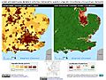
London, England: Population density and low elevation coastal zones. Canvey Island is particularly vulnerable to sea level rise.
.jpg)
See also
 In Spanish: Canvey Island para niños
