
Topography facts for kids
Have you ever looked at a map and wondered how it shows mountains, valleys, and rivers? That's where topography comes in! Topography is all about describing the shape of the land. The word comes from ancient Greek words meaning "place" and "to write." It's a super important part of earth science, which studies our planet.
When we talk about the topography of an area, we're looking at its natural features. This includes big things like mountains, hills, and valleys. It also covers water features such as rivers, lakes, and even the coastline where land meets the sea. Basically, anything that describes how the land looks and feels is part of its topography. Special maps called Topographic maps are designed to show these shapes in detail.
Contents
What is Topography?
Topography is the study of the Earth's surface features. It looks at both natural shapes and those made by humans. For example, a natural feature could be a tall mountain, while a human-made feature might be a large dam or a road.
Geographers and scientists use topography to understand how land was formed. They also use it to predict how it might change over time. It helps us learn about the history of a place and what it might be like in the future.
Understanding Land Shapes
Topography includes many different types of landforms. Here are some common ones:
- Mountains: Very tall, rocky landforms that rise high above the surrounding area. They often have steep sides and pointed tops.
- Hills: Smaller than mountains, hills are raised areas of land. They are usually rounded and not as steep.
- Valleys: Low areas of land often found between hills or mountains. Rivers often flow through valleys.
- Plateaus: Large, flat areas of land that are much higher than the land around them. Think of them as high, flat tables.
- Rivers and Lakes: These water bodies are also part of topography. They shape the land around them over many years.
- Coastlines: The edge where land meets the sea or a large lake. Coastlines can be rocky, sandy, or marshy.
How Topographic Maps Work
One of the best ways to see topography is on a Topographic map. These maps are special because they show the height and shape of the land. They do this using something called contour lines.
- Contour lines are lines on a map that connect points of the same elevation (height above sea level).
- When contour lines are close together, it means the land is steep.
- When they are far apart, the land is flatter.
- These maps also show rivers, roads, buildings, and other features. They are very useful for hiking, planning construction, or even just exploring.
Why Topography Matters
Understanding topography is important for many reasons:
- Planning and Building: Engineers use topographic information to decide where to build roads, bridges, and buildings. They need to know if the land is flat enough or too steep.
- Natural Disasters: Knowing the topography helps predict areas at risk from floods, landslides, or tsunamis. For example, low-lying coastal areas are more likely to flood.
- Environmental Studies: Scientists study topography to understand how water flows, how plants grow in different areas, and how animals use the landscape.
- Outdoor Activities: Hikers, climbers, and campers use topographic maps to plan their routes and stay safe in nature.
Topography helps us understand our world better, from the smallest hill to the largest mountain range!
Images for kids
-
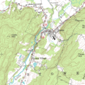
A topographic map with contour lines
-
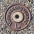
A surveying point in Germany
-
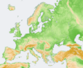
A map of Europe using elevation modeling
-
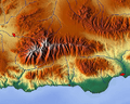
Relief map: Sierra Nevada Mountains, Spain


See also
 In Spanish: Topografía para niños
