
River Thames facts for kids
Quick facts for kids River Thames |
|
|---|---|

|
|

Map of the Thames within southern England
|
|
| Country | England |
| Counties | Gloucestershire, Wiltshire, Oxfordshire, Berkshire, Buckinghamshire, Surrey, Greater London, Kent, Essex |
| Towns/cities | Cricklade, Lechlade, Oxford, Abingdon, Wallingford, Reading, Henley-on-Thames, Marlow, Maidenhead, Windsor, Staines-upon-Thames, Walton-on-Thames, Sunbury-on-Thames, Kingston upon Thames, Twickenham, London (inc. the City), Dagenham, Erith, Dartford, Grays, Gravesend |
| Physical characteristics | |
| Main source | Thames Head, Gloucestershire, UK 110 m (360 ft) 51°41′40″N 02°01′47″W / 51.69444°N 2.02972°W |
| 2nd source | Ullenwood, Gloucestershire, UK 214 m (702 ft) 51°50′49″N 02°04′41″W / 51.84694°N 2.07806°W |
| River mouth | Thames Estuary, North Sea Southend-on-Sea, Essex, UK 0 m (0 ft) 51°30′00″N 00°36′36″E / 51.50000°N 0.61000°E |
| Length | 346 km (215 mi) |
| Discharge (location 2) |
|
| Discharge (location 3) |
|
| Discharge (location 4) |
|
| Discharge (location 5) |
|
| Basin features | |
| Basin size | 12,935 km2 (4,994 sq mi) |
The River Thames ( TEMZ) is a river that flows through southern England including London. At 215 miles (346 km), it is the longest river entirely in England and the second-longest in the United Kingdom, after the River Severn.
The river rises at Thames Head in Gloucestershire and flows into the North Sea near Tilbury, Essex and Gravesend, Kent, via the Thames Estuary. From the west it flows through Oxford (where it is sometimes called the Isis), Reading, Henley-on-Thames and Windsor. The Thames also drains the whole of Greater London.
In London there are many sightseeing tours in tourist boats, past riverside attractions such as the Houses of Parliament and the Tower of London. There are also regular riverboat services co-ordinated by London River Services. London City Airport is situated on the Thames, in East London.
Contents
How long is the Thames?
The River Thames is about 215 miles (346 kilometers) long. This makes it the longest river that stays completely within England. The River Severn is a little bit longer overall in the UK, but it flows through Wales as well as England.
Course


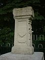
The River Thames starts its journey in the beautiful Cotswold Hills in Gloucestershire, a county in southwest England. The traditional spot for the source is called Thames Head, marked by a stone in a field. However, some people think a nearby stream called the River Churn, which starts at Seven Springs, might be the true beginning because it flows all year round and is a bit longer.
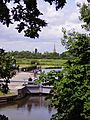
From its source, the Thames flows eastwards, winding its way through the countryside and several towns and cities. It passes through places like Oxford (where it's sometimes called the River Isis), Reading, and Windsor. Finally, after a long journey, the river reaches the Thames Estuary, a wide area where the river meets the salty water of the North Sea, near places like Tilbury and Gravesend.
The Thames is divided into two main parts: the non-tidal section and the tidal section. The non-tidal part is the upper section, from the source down to Teddington Lock in west London. This part is about 147 miles (237 kilometers) long, and the water flows in one direction, downhill. The tidal part stretches from Teddington Lock all the way to the Thames Estuary and the North Sea. This section is about 68 to 99 miles long (109 to 160 kilometers), and here the water level goes up and down with the ocean tides. The difference between high tide and low tide in the tidal Thames can be quite big, up to 23 feet (7 meters)!
Cities and towns along the Thames
The River Thames flows through many interesting cities and towns. Some of the notable ones include:
- Oxford: Famous for its historic university. The river here is sometimes called the River Isis.
- Reading: A large town in Berkshire.
- Henley-on-Thames: Known for the famous Henley Royal Regatta rowing race.
- Windsor: Home to the magnificent Windsor Castle, a royal residence.
- Staines-upon-Thames: A town in Surrey.
- Kingston upon Thames: A busy town in southwest London.
- London: The capital city of England and the UK. The Thames flows right through the heart of London, passing by many famous landmarks.
Wildlife

Various species of birds feed off the river or nest on it, some being found both at sea and inland. These include cormorant, black-headed gull and herring gull. The mute swan is a familiar sight on the river but the escaped black swan is more rare. The annual ceremony of Swan Upping is an old tradition of counting stocks.
Non-native geese that can be seen include Canada geese, Egyptian geese and bar-headed geese, and ducks include the familiar native mallard, plus introduced Mandarin duck and wood duck. Other water birds to be found on the Thames include the great crested grebe, coot, moorhen, heron and kingfisher. Many types of British birds also live alongside the river, although they are not specific to the river habitat.
The Thames contains both sea water and fresh water, thus providing support for seawater and freshwater fish. However, many populations of fish are at risk and are being killed in tens of thousands because of pollutants leaking into the river from human activities. Salmon, which inhabit both environments, have been reintroduced and a succession of fish ladders have been built into weirs to enable them to travel upstream.
On 5 August 1993, the largest non-tidal salmon in recorded history was caught close to Boulters Lock in Maidenhead. The specimen weighed 14+1⁄2 lb (6.6 kg) and measured 22 in (56 cm) in length. The eel is particularly associated with the Thames and there were formerly many eel traps. Freshwater fish of the Thames and its tributaries include brown trout, chub, dace, roach, barbel, perch, pike, bleak and flounder. Colonies of short-snouted seahorses as well as tope and starry smooth-hound sharks have also recently been discovered in the river. The Thames is also host to some invasive crustaceans, including the signal crayfish and the Chinese mitten crab.
Aquatic mammals are also known to inhabit the Thames. The population of grey and harbour seals numbers up to 700 in the Thames Estuary. These animals have been sighted as far upriver as Richmond. Bottlenose dolphins and harbour porpoises are also sighted in the Thames.
On 20 January 2006, a 16–18 ft (4.9–5.5 m) northern bottle-nosed whale was seen in the Thames as far upstream as Chelsea. This was extremely unusual: this whale is generally found in deep sea waters. Crowds gathered along the riverbanks to witness the spectacle but there was soon concern, as the animal came within yards of the banks, almost beaching, and crashed into an empty boat causing slight bleeding. About 12 hours later, the whale is believed to have been seen again near Greenwich, possibly heading back to sea. A rescue attempt lasted several hours, but the whale died on a barge. See River Thames whale.
Famous bridges and landmarks


The Thames is famous for the many bridges that cross it, especially in London. There are over 200 bridges along the whole river!
- London Bridge: This is the oldest river crossing in London, with a history going back to Roman times. The bridge you see today was opened in 1973.
- Tower Bridge: This is one of the most recognizable bridges in the world! It's a special type of bridge called a bascule bridge, which means the middle sections can be lifted up to let tall ships pass through. It was finished in 1894.
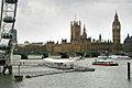
- Westminster Bridge: This bridge is near the Houses of Parliament and the famous Big Ben clock tower. It was built in the 1700s and is painted green, the same color as the seats in the House of Commons in the Houses of Parliament.
- Millennium Bridge: This is a footbridge (only for people walking) that crosses the Thames in London. It opened in the year 2000 and links the Tate Modern art gallery on the south side with St Paul's Cathedral on the north side.
- Other Bridges: There are many other interesting bridges, each with its own story, like Albert Bridge with its many lights, and older bridges further upstream like Radcot Bridge, which is thought to be the oldest surviving bridge on the Thames, built around 1200.
History


People have lived near the Thames since prehistoric times.
Starting in AD 43, under the Emperor Claudius, the Romans occupied England and, recognising the river's strategic and economic importance, built fortifications along the Thames valley. Cornhill and Ludgate Hill provided a defensible site near a point on the river both deep enough for the era's ships and narrow enough to be bridged; Londinium (London) grew up around the Walbrook on the north bank around the year 47.
When King William had won total control of the strategically important Thames Valley, he went on to invade the rest of England. He had many castles built, including those at Wallingford, Rochester, Windsor and most importantly the Tower of London.
In Tudor and Stuart times, various kings and queens built magnificent riverside palaces at Hampton Court, Kew, Richmond on Thames, Whitehall and Greenwich.
As early as the 1300s, the Thames was used to dispose of waste matter produced in the city of London, thus turning the river into an open sewer. In the 1800s, the river became very dirty. There was even a time in 1858 called "The Great Stink" because the river smelled so bad that people in the Houses of Parliament, which are right next to the river, had trouble working! This problem led to the building of a new sewer system for London, which helped to make the river cleaner.
In the 1950s, the Thames was in a very poor state and was even declared "biologically dead," meaning that very few living things could survive in it. However, thanks to a lot of hard work, better sewage treatment, and efforts to control pollution, the river has become much cleaner. Today, it is home to lots of different kinds of wildlife again.
Pollution
Treated waste water from all the towns and villages in the Thames catchment flow into the Thames via sewage treatment plants. This includes all that from Swindon, Oxford, Berkshire and almost all of Surrey.
However, untreated sewage still often enters the Thames during wet weather. When London's sewerage system was built, sewers were designed to overflow through discharge points along the river during heavy storms. Originally, this would happen once or twice a year, however overflows now happen once a week on average.
To reduce the release of this into the river, the Thames Tideway Scheme is currently under construction at a cost of £4.2 billion. This project will collect sewage from the Greater London area before it overflows, before channelling it down a 25 km (15 mi) tunnel underneath the tidal Thames, so that it can be treated at Beckton Sewage Treatment Works. The project is planned to reduce sewage discharges into the Thames in the Greater London area by 90%, dramatically increasing water quality. After its completion, it is estimated that two million tonnes of sewage will still enter the Thames each year.
Mercury levels
Mercury (Hg) is an environmentally persistent heavy metal which can be toxic to marine life and humans. Mercury concentrations in the River Thames decrease downstream from London to the outer Estuary, with the total Hg levels ranging from 0.01 to 12.07 mg/kg, giving a mean of 2.10 mg/kg which is higher than many other UK and European river estuaries.
Plastic pollution
The Thames has relatively high levels of plastic pollution, with an estimated 94,000 microplastics per second moving through some parts of the river. These microplastics come from the breakdown of larger items but also glitter and microbeads from cosmetics.
Sport
There are several watersports prevalent on the Thames, with many clubs encouraging participation and organising racing and inter-club competitions.
Rowing

The Thames is the historic heartland of rowing in the United Kingdom. There are over 200 clubs on the river, and over 8,000 members of British Rowing (over 40% of its membership). Most towns and districts of any size on the river have at least one club. Internationally attended centres are Oxford, Henley-on-Thames and events and clubs on the stretch of river from Chiswick to Putney.
Two rowing events on the River Thames are traditionally part of the wider English sporting calendar:
The University Boat Race (between Oxford and Cambridge) takes place in late March or early April, on the Championship Course from Putney to Mortlake in the west of London.
Henley Royal Regatta takes place over five days at the start of July in the upstream town of Henley-on-Thames. Besides its sporting significance the regatta is an important date on the English social calendar alongside events like Royal Ascot and Wimbledon.
Other significant or historic rowing events on the Thames include:
- The Head of the River Race and Women's Eights Head of the River Race (8+) (i.e. coxed eights), Schools' Head, Veterans Head, Scullers Head, Fours Head (HOR4s), and Pairs Head (shorter) on the Championship Course
- The Wingfield Sculls on the same course: (1x) (single sculling) championship
- Doggett's Coat and Badge for apprentice watermen of London, one of the oldest sporting events in the world
- Henley Women's Regatta
- The Henley Boat Races currently for the Lightweight (men's and women's) crews of Oxford and Cambridge universities
- The Oxford University bumping races known as Eights Week and Torpids
Other regattas, head races and university bumping races are held along the Thames which are described under Rowing on the River Thames.
Sailing

Sailing is practised on both the tidal and non-tidal reaches of the river. The highest club upstream is at Oxford. The most popular sailing craft used on the Thames are lasers, GP14s and Wayfarers. One sailing boat unique to the Thames is the Thames Rater, which is sailed around Raven's Ait.
Skiffing
Skiffing has dwindled in favour of private motor boat ownership but is competed on the river in the summer months. Six clubs and a similar number of skiff regattas exist from the Skiff Club, Teddington upstream.
Punting
Unlike the "pleasure punting" common on the Cherwell in Oxford and the Cam in Cambridge, punting on the Thames is competitive as well as recreational and uses narrower craft, typically based at the few skiff clubs.
Kayaking and canoeing
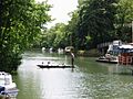
Kayaking and canoeing are common, with sea kayakers using the tidal stretch for touring. Kayakers and canoeists use the tidal and non-tidal sections for training, racing and trips. Whitewater playboaters and slalom paddlers are catered for at weirs like those at Hurley Lock, Sunbury Lock and Boulter's Lock. At Teddington just before the tidal section of the river starts is Royal Canoe Club, said to be the oldest in the world and founded in 1866. Since 1950, almost every year at Easter, long distance canoeists have been competing in what is now known as the Devizes to Westminster International Canoe Race, which follows the course of the Kennet and Avon Canal, joins the River Thames at Reading and runs right up to a grand finish at Westminster Bridge.
Swimming
Organised swimming events take place at various points generally upstream of Hampton Court, including Windsor, Marlow and Henley. In 2011, comedian David Walliams swam the 140 mi (230 km) from Lechlade to Westminster Bridge and raised over £1 million for charity.
In non-tidal stretches swimming was, and still is, a leisure and fitness activity among experienced swimmers where safe, deeper outer channels are used in times of low stream.
In the arts
The River Thames has been a subject for artists, great and minor, over the centuries. Four major artists with works based on the Thames are Canaletto, J. M. W. Turner, Claude Monet and James Abbott McNeill Whistler. The 20th-century British artist Stanley Spencer produced many works at Cookham.
John Kaufman's sculpture The Diver: Regeneration is sited in the Thames near Rainham.
The river and bridges are portrayed as being destroyed – together with much of London – in the film Independence Day 2.
- The Thames in the arts
-
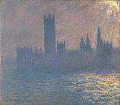
Houses of Parliament Sunlight Effect (Le Parlement effet de soleil) – Claude Monet
-
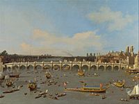
The first Westminster Bridge as painted by Canaletto in 1746
-
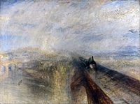
Maidenhead Railway Bridge as Turner saw it in 1844
-
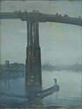
Whistler's Nocturne in Blue and Gold: Old Battersea Bridge (c. 1872–1875)
-
Foggy Morning on the Thames – James Hamilton (between 1872 and 1878)
-
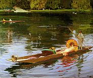
Boating on the Thames - John Lavery, c. 1890
_-_Claude_Monet.jpg)


Literature

The Thames is mentioned in many works of literature including novels, diaries and poetry.
Most of Dickens' other novels include some aspect of the Thames. Oliver Twist finishes in the slums and rookeries along its south bank. The Sherlock Holmes stories by Arthur Conan Doyle often visit riverside parts as in The Sign of Four.
T. S. Eliot makes several references to the Thames in The Fire Sermon, Section III of The Waste Land.
The Sweet Thames line is taken from Edmund Spenser's Prothalamion which presents a more idyllic image:
- Along the shoare of silver streaming Themmes;
- Whose rutty banke, the which his river hemmes,
- Was paynted all with variable flowers.
- And all the meads adorn'd with daintie gemmes
- Fit to deck maydens bowres


Interesting facts about the Thames
- Some of the earliest written references to the Thames (Latin: Tamesis) occur in Julius Caesar's account of his second expedition to Britain in 54 BC.
- The Thames provides two-thirds of London's drinking water.
- The river is fed by at least 50 tributaries.
- The name "Thames" might come from an ancient Celtic word meaning "dark."
- The Thames through Oxford is sometimes called the Isis.
- The tidal stretch of the river is known as "the Tideway". Tide tables are published by the Port of London Authority and are available online.
- Until the middle of the Victorian era malaria was commonplace beside the River Thames, even in London, and was frequently lethal.
- The sea level in the Thames estuary is rising and the rate of rise is increasing. Since the beginning of the 20th century, rates of sea level rise range from 1.22 mm per year to 2.14 mm per year.
- The river contains over 80 islands.
- The width of the Thames changes a lot along its course. Near the source, it's just a small stream. Even in some areas further downstream, it can be as narrow as 18 meters. But by the time it reaches the estuary, where it meets the sea, it becomes very wide, about 18 miles (28.9 kilometers) across!
- By the 18th century, the Thames was one of the world's busiest waterways, as London became the centre of the vast, mercantile British Empire.
- Kenneth Grahame's The Wind in the Willows is set in the middle to upper reaches of the river. It is considered one of the most beloved works of children's literature.
- One of the worst river disasters in England was on 3 September 1878, when the crowded pleasure boat Princess Alice collided with the Bywell Castle, killing over 640 people.
- Alongside the entire river runs the Thames Path, a National Route for walkers and cyclists.
- In 2010, the Thames won the largest environmental award in the world: the $350,000 International Riverprize.
- In 2006, British swimmer and environmental campaigner Lewis Pugh became the first person to swim the full length of the Thames.
Images for kids
-
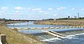
The Jubilee River at Slough Weir
-
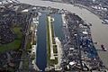
London City Airport is on the site of a dock.
-
St John's Lock, near Lechlade
-
The River Thames in Oxford
-
London Stone at Staines, built in 1285 marked the customs limit of the Thames and the City of London's jurisdiction.
-
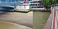
Waterstand of Thames at low tide (left) and high tide (right) in comparison at Blackfriars Bridge in London
-
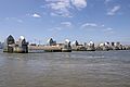
The Thames Barrier provides protection against floods.
-

European LGM refuges, 20,000 years ago. The Thames was a minor river that joined the Rhine, in the southern North Sea basin at this time.
Solutrean and Proto Solutrean Cultures Epi Gravettian Culture -
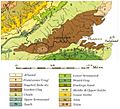
A geological map of the London Basin; the London Clay is marked in dark brown.
-
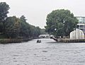
The confluence of the Rivers Thames and Brent. The narrowboat is heading up the River Brent. From this point as far as Hanwell the Brent has been canalised and shares its course with the main line of the Grand Union Canal. From Hanwell the Brent can be traced to various sources in the Barnet area.
-
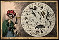
Satirical cartoon by William Heath, showing a woman observing monsters in a drop of London water (at the time of the Commission on the London Water Supply report, 1828)
-
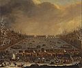
River Thames frost fair, circa 1685
-
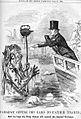
Michael Faraday giving his card to Father Thames, caricature commenting on a letter of Faraday's on the state of the river in The Times in July 1855
-
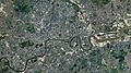
The Thames as it flows through east London, with the Isle of Dogs in the centre
-
A view of the Thames as it passes through London, composed of 29 photos taken from the ISS in 2021
-
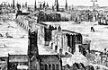
A 1616 engraving by Claes Van Visscher showing the Old London Bridge, with St Mary's Overie (over-the-river), now Southwark Cathedral in the foreground
-
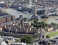
The Tower of London begun in the 11th century, with Tower Bridge, built 800 years later.
-
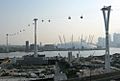
The London Cable Car, over the River Thames
-
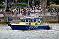
Metropolitan Marine Policing Unit patrol vessel, Nina Mackay III, on the Thames River in London
-
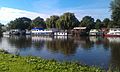
Houseboats on the River Thames, in the St Margaret's, Twickenham district
-
Passenger service on the River Thames


_by_Claes_Van_Visscher.jpg)


Related articles
See also
 In Spanish: Río Támesis para niños
- Dartford Cable Tunnel
- Foreshore of the River Thames
- List of locations in the Port of London
- List of rivers of the United Kingdom
- Nore
- River and Rowing Museum
- Steamboat – reference Thames Steamboats
- Subterranean rivers of London
- Thames Discovery Programme
- Thames sailing barge
- Thames steamers
- Tyburn (stream)
