
Isle of Dogs facts for kids
Quick facts for kids Isle of Dogs |
|
|---|---|
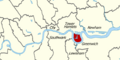
 Location of the Isle of Dogs within Inner London |
|
| OS grid reference | TQ375785 |
| London borough | |
| Ceremonial county | Greater London |
| Region | |
| Country | England |
| Sovereign state | United Kingdom |
| Post town | LONDON |
| Postcode district | E14 |
| Dialling code | 020 |
| Police | Metropolitan |
| Fire | London |
| Ambulance | London |
| EU Parliament | London |
| UK Parliament |
|
| London Assembly | |

The Isle of Dogs is a large piece of land in East London, England. It's almost completely surrounded by the River Thames, which curves around it on three sides. This area includes well-known places like Cubitt Town, Millwall, and Canary Wharf.
Historically, the Isle of Dogs was part of a larger area called Poplar. Even though people have called it the "Isle of Dogs" for a long time, it only became an official neighbourhood name in 1987. Locals have often simply called it "the Island" since the 1800s.
The area was once known as Stepney Marsh. An old drawing of London from 1543, called "Panorama of London," already shows and mentions the Isle of Dogs. Records from 1520 show that ships carrying the English royal family to Calais docked on the island's southern side.
Contents
Why is it Called the Isle of Dogs?
The first time "Isle of Dogs" was written down was in 1520. It was in a list of things bought for a ship docked there.
There are many ideas about how the Isle of Dogs got its name:
- Some people believe it was where Edward III kept his hunting dogs, called greyhounds.
- Others think it might be a changed version of "Isle of Ducks," because many wild birds lived in the marshes.
- A play from 1597, also called The Isle of Dogs, made fun of Great Britain. This play got one of its writers, Ben Jonson, sent to prison.
- It might be linked to Dutch engineers who helped reclaim the land after a big flood.
- Perhaps it's from the word "dykes," which are walls built to hold back water, and over time it became "dogs."
- Another idea is that King Henry VIII kept his hunting dogs in old farm buildings on the island. He also kept deer in nearby Greenwich Park.
The Canary Wharf area, located on the Isle of Dogs, got its name from ships that traded with the Canary Islands. These islands were named "Dog Islands" in Latin. The Talbot dog on the coat of arms for the London Borough of Tower Hamlets also represents the Isle of Dogs.
Life on the Island
.jpg)
After the docks were built, especially the West India Docks, more people moved to the area. Because of this, locals started calling it "The Island." This area includes Millwall, Cubitt Town, and Blackwall.
The Isle of Dogs used to have the most council housing (public housing) in England. Today, it's famous for the huge Canary Wharf office complex. One Canada Square, also known as the Canary Wharf Tower, is one of Britain's tallest buildings, standing at 244 meters (801 feet) high.
The Isle of Dogs is a place of big differences. It has some of the richest areas in the country, thanks to Canary Wharf, but also some of the poorest.
History of the Isle of Dogs


Early Days
The Isle of Dogs is located quite a distance downriver from the City of London. It was originally a marshy area, often several feet below water when the tide was high. In the Middle Ages, people started to reclaim the land by building earthen banks to keep the water out. This process is called "inning."
However, these banks could break. In 1448, a flood covered the land for 40 years. In 1660, the river began to break through the narrowest part of the peninsula. People stopped this from happening completely, but it left a 5-acre lake called Poplar Gut.
One old road crossed the marshes to a ferry. The marshland was good for grazing animals, and cattle were killed in fields known as the "Killing Fields." The western side of the island was called "Marsh Wall." This area later became known as "Millwall" because of the docks and the many windmills built there to help with drainage.
Industry and Docks

In 1802, work began on the West India Docks on the Isle of Dogs. These docks brought many related businesses, like flour and sugar processing, and also shipbuilding. On January 31, 1858, the largest ship of its time, the SS Great Eastern, was launched from Millwall. This ship, designed by Isambard Kingdom Brunel, was 211 meters (692 feet) long. It was too big to be launched forward into the river, so it had to be launched sideways. This was the last very large ship built on the Island because it was so difficult.

The Isle of Dogs became a busy urban area in the 1800s after the West India Docks opened in 1802. This was a very successful time for the area, making it an important trading center. The East India Docks opened in 1806, followed by Millwall Dock in 1868.
By the 1880s, dock workers started to form unions to fight for better pay and conditions. This led to the London Dock Strike of 1889, where workers demanded more pay and an end to unfair temporary work. The strike was a success for the workers and helped start a national movement for workers' rights.
In 1909, all three dock systems came under the control of the Port of London Authority. With docks stretching across the island, the Isle of Dogs truly became like an island.
Many dock workers lived on the "island." By 1901, about 21,000 people lived there, mostly relying on the river trade. The Isle of Dogs was connected to London by the London and Blackwall Railway, which opened in 1840. In 1902, a ferry to Greenwich was replaced by the Greenwich foot tunnel, an underwater tunnel for walkers. Island Gardens park was created in 1895, offering great views across the river. The railway closed in 1926. Until the Docklands Light Railway opened in 1987, buses were the only public transport to and from the Island. These buses were often delayed by bridges opening for ships. This made the Island feel very separate from the rest of London.
World War II and Decline

During World War II, the docks were a major target for German planes. They were heavily bombed, causing a lot of damage and putting many docks out of action. Many local people were killed. Even today, unexploded bombs from this time are sometimes found. Anti-aircraft guns were placed on Mudchute Farm, and their concrete bases can still be seen.
After the war, the docks briefly became busy again and were even updated in 1967. However, with the invention of containerisation (using large metal boxes to ship goods), the docks became old-fashioned because they couldn't handle the new containers. The docks gradually closed during the 1970s, with the last ones closing in 1980. This left the area looking very run-down, with many empty and abandoned spaces.
New Beginnings
The closing of the docks led to many people losing their jobs and facing hardship. In protest, a local community leader named Ted Johns and his supporters jokingly declared the area the "Republic of the Isle of Dogs" in 1970. For one day, they blocked the two bridges that were the only road access to the area.
To help the area recover, the London Docklands Development Corporation (LDDC) was set up in 1981. The Isle of Dogs became a special "enterprise zone." New homes, offices, and transport links were built. This included the Docklands Light Railway and later the Jubilee line extension, which finally brought the London Underground to the area.
Since the late 1980s, the area has been transformed by the growing Canary Wharf development. It now has a huge amount of office and shopping space, and over 93,000 people work in Canary Wharf alone.
Important Events
On February 9, 1996, a serious incident took place near South Quay DLR station on the Isle of Dogs. It caused harm and disruption to many people.
Education
There are four state primary schools on the Isle of Dogs: Cubitt Town Junior School, Arnhem Wharf, Harbinger School, and St Edmunds. There is also a private primary school, River House Montessori.
George Green's School is a secondary school located at the southern end of the island. Canary Wharf College is a free school on the Island that teaches both primary and secondary students.
Getting Around the Isle of Dogs
Train and Tube Stations
The closest London Underground station is Canary Wharf on the Jubilee line. From here, you can reach places like Regent's Park, Westminster, and the Queen Elizabeth Olympic Park in about 20 minutes.
The Docklands Light Railway (DLR) runs through the Isle of Dogs. Its stations include Canary Wharf, Heron Quays, South Quay, Crossharbour, Mudchute, and Island Gardens. You can get to the City of London, Tower Hill, and Greenwich within 20 minutes by DLR.
The Elizabeth line's Canary Wharf station opened in 2022. It offers fast connections to the West End, Paddington Station, Heathrow Airport, and Abbey Wood.
Bus Routes
Several London bus routes serve the Isle of Dogs, including:
- London Buses route 135
- London Buses route 277
- London Buses route D3
- London Buses route D6
- London Buses route D7
- London Buses route D8
- London Buses route N550 (night bus)
River Boat Services
You can also travel by boat! Regular boat services run from Masthouse Terrace Pier and Canary Wharf Pier. Thames Clippers offers services to places like Woolwich Arsenal Pier, Greenwich Pier, and various spots in the City of London and West End of London. There's also a special service to O2 Arena.
Walking and Cycling
The Thames Path is a walking trail that runs along the river. At the southern end of the Isle of Dogs, the Greenwich foot tunnel allows people to walk under the river to Greenwich. National Cycle Network route 1 also goes through this tunnel (but you must walk your bike).
Airport and Helipad
The closest airport is London City Airport, which is about 25 minutes from Canary Wharf by DLR. There is also a private helipad on the west side of the Island.
Watersports
The large docks on the Isle of Dogs are perfect for various watersports. You can enjoy sailing, kayaking, windsurfing, and standup paddleboarding. The Docklands Sailing and Watersports Centre is a popular spot for these activities.
The Isle of Dogs in Media
- The play The Isle of Dogs by Ben Jonson and Thomas Nashe was performed in 1597.
- The famous poem The Waste Land by T.S. Eliot mentions the Isle of Dogs.
- Many blockbuster films have used the Isle of Dogs as a filming location, including the James Bond film The World Is Not Enough, Batman Begins, The Constant Gardener, Harry Potter and the Order of the Phoenix, and Love Actually.
- The 1980 British film The Long Good Friday and the 2007 horror film 28 Weeks Later also feature the Isle of Dogs.
- The director Wes Anderson was inspired by a road sign to the Isle of Dogs while filming in East London. This led him to name his 2018 animated film Isle of Dogs after the area.
Images for kids
-
Location of the Isle of Dogs within Inner London
See also
 In Spanish: Isla de los Perros (Londres) para niños
