Rainham, London facts for kids
Quick facts for kids Rainham |
|
|---|---|
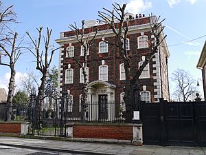
 Rainham Hall in Broadway |
|
| Population | 12,482 (Rainham and Wennington ward 2011) |
| OS grid reference | TQ525825 |
| • Charing Cross | 13.6 mi (21.9 km) W |
| London borough | |
| Ceremonial county | Greater London |
| Region | |
| Country | England |
| Sovereign state | United Kingdom |
| Post town | RAINHAM |
| Postcode district | RM13 |
| Dialling code | 01708 |
| Police | Metropolitan |
| Fire | London |
| Ambulance | London |
| EU Parliament | London |
| UK Parliament |
|
| London Assembly |
|
Rainham (pronounced RAY-nəm) is a busy area in East London, England. It's part of the London Borough of Havering. Long ago, Rainham was a small village in the county of Essex.
Today, Rainham is about 13.6 miles (21.9 km) east of Charing Cross in central London. It has grown from a historic village into a lively residential area. To the south, along the River Thames, you'll find a commercial and industrial zone. Rainham became part of Greater London in 1965. Over time, it changed from a farming community to a place with many factories and businesses. Now, it's being updated as part of a big project called Thames Gateway.
Contents
History of Rainham
What's in a Name?
The name Rainham comes from old English words. It was written as Raineham in the Domesday Book of 1086. This name likely means 'homestead or village of a man named Regna'.
Another idea is that it's linked to Rainham in Kent. That name might mean 'home of the ruling people'. This connection is interesting because ancient burial sites from the Jutes (a Germanic tribe) have been found in Rainham.
Bronze Age Treasures
In 2018, a huge collection of ancient objects was found in Rainham. This collection is called the Havering hoard. It includes 453 items from the late Bronze Age, which was about 900 to 800 BC.
The hoard weighs over 45 kilograms! It contains swords, axe heads, spear heads, knives, daggers, and bracelets. There were also tools for woodworking and metal ingots. This discovery tells us a lot about people who lived here long ago.
How Rainham Grew
For many years, Rainham was a farming village. People used the River Thames to trade goods. In the 1500s, there was a boat-builder and a tannery (where leather is made). Farms in Rainham traded with the City of London even in the Middle Ages.
After a new dock was built in the 1720s, trade increased. Farmers even brought manure from London to help their fields. By 1929, most farms had become market gardening areas, growing fruits and vegetables.
Travel improved too. In the 1700s, new coach routes connected Rainham to other places. A railway station opened in 1854. More factories, like chemical plants, started to appear from 1869. The Murex iron company moved here in 1917 and grew into part of the British Oxygen Company. After World War II, more industries like brickmaking and gravel digging started up.
Building a Suburb

The oldest part of Rainham grew around the Church of St Helen and St Giles. This church is the only medieval building still standing. In the 1700s, as trade grew, new buildings like Rainham Hall were built.
By the 1880s, new roads were laid out. Many semi-detached and terraced houses were built. A small holiday area also grew around a pub by the river. People came for day trips. But as the Thames became more industrial, this resort disappeared by 1945.
After World War I, Rainham really started to become a London suburb. Some large land areas were sold for housing. Local residents worked hard to make sure the area had good roads and sewage systems as it grew.
How Rainham is Governed

Rainham is part of the Dagenham and Rainham area for national elections. This area chooses one person, called a Member of Parliament (MP), to represent them in the UK Parliament. The current MP is Jon Cruddas.
For local matters, Rainham is in the Rainham and Wennington ward. This ward elects three councillors to the Havering London Borough Council. These councillors help make decisions about local services like parks, rubbish collection, and libraries. In Rainham, a group called the Rainham and Wennington Residents Independent Association is very active. They work to make sure local people's voices are heard.
Rainham is also part of the Havering and Redbridge area for the London Assembly. The London Assembly helps oversee the Mayor of London and important city-wide issues.
Rainham's Geography
Rainham is mostly built on gravel. The land rises to about 60 to 100 feet (18 to 30 meters) above sea level. Along the southern edge, near the River Thames, there are marshlands. These marshlands are only about 5 feet (1.5 meters) above sea level. The River Ingrebourne forms the western border of Rainham.
Some parts of London, including Rainham, can be at risk of flooding. The old part of Rainham, including the town centre, is a special "conservation area." This means its historic character is protected.
To the south, some land has been used for digging up gravel. About 200 acres (0.8 km²) of Rainham Marshes have been filled with soil from the River Thames. Rainham is a post town in the RM postcode area. This area covers a large part of southern Havering, including places like Coldharbour, South Hornchurch, and Wennington.
People of Rainham
Information about the people living in Rainham comes from official surveys. In 2001, the Rainham and Wennington area had 12,114 people. Most people (93.35%) were White. Smaller groups included Asian (2.81%), Black (2.25%), and Chinese or other (0.32%).
Most people (75.58%) said they were Christian. About 12.04% said they had no religion.
In terms of jobs and social groups, about 37.9% of people in Rainham and Wennington were in the ABC1 social category. This group usually includes managers, professionals, and office workers.
The age groups in Rainham were:
- 0–4 years old: 5.32%
- 5–15 years old: 15.63%
- 16–19 years old: 5.02%
- 20–44 years old: 33.78%
- 45–64 years old: 24.92%
- 65 years and older: 15.32%
Most people (70.49%) said their health was good. About 16.41% of people had a long-term illness that limited their daily activities.
Rainham's Economy
The northern part of Rainham is an important local centre for businesses. It has many shops and commercial buildings. The London Borough of Havering sees Rainham as one of its seven main town centres. Its shopping area is mainly along Upminster Road South and Broadway.
The southern part of Rainham is a major area for jobs. It's part of the London Riverside business district. You'll find the main factory for Tilda Rice here. Many big companies also have offices and operations in Rainham. These include Keebles, Carpetright, Harveys Furniture, and Rainham Steel.
There are plans to build 3,200 new homes in Rainham. Old industrial buildings will be updated to create new mixed-use areas. This is part of the London Thames Gateway Development Corporation's plans for the area.
Riverside Sewage Treatment Works
The Riverside sewage treatment works is a large facility in Rainham. It cleans up to 94,000 cubic meters of sewage every day. Some of this waste comes from local factories. The treated water is then released into Rainham Creek, which flows into the River Thames.
Before 1998, the leftover sludge from the sewage was dumped into the sea. But this practice was stopped. Now, the sludge from Riverside is sent to another plant for treatment. Since 2012, the Riverside plant has special equipment that turns solid waste into renewable energy. This energy is enough to power the entire site!
Culture and Fun
The Havering Council's plan for the area says that nearby Hornchurch is the main place for culture. It has a large theatre and art spaces. Romford offers the biggest choice of entertainment facilities in the region.
Getting Around Rainham
Roads and Trains
The A1306 road goes through Rainham. It's a good alternative route to the main A13 road, which connects Central London to the Dartford Crossing.
The London, Tilbury & Southend line railway also passes through Rainham. Rainham railway station has c2c train services. These trains run between Fenchurch Street in the City of London and Grays. Rainham station is in London fare zone 6 for train fares.
Buses and Walking
Several London bus routes serve Rainham. These include routes 103, 165, 287, and 372. They connect Rainham to places like Barking, Elm Park, Hornchurch, Lakeside, and Romford.
The London Loop is a long walking route that goes through Rainham. It's the end point of section 23 (from Upminster Bridge) and the start of section 24 (to Purfleet).
Future Transport Plans
There are ideas for new transport links in the future. One idea is the Belvedere Crossing, which would be a new tunnel or bridge between Belvedere and Rainham.
There have also been discussions about extending the Docklands Light Railway (DLR) to Rainham. The DLR is a popular light rail system in East London. While a full DLR extension might not happen, Rainham is planned to be connected to the DLR at Dagenham Dock by a new bus rapid transit system called the East London Transit.
 | Tommie Smith |
 | Simone Manuel |
 | Shani Davis |
 | Simone Biles |
 | Alice Coachman |


