
Romford facts for kids
Quick facts for kids Romford |
|
|---|---|
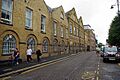
  .JPG)   Clockwise from top: Parish Church of St Edward the Confessor; Havering Town Hall; South Street; Havering Museum (former Ind Coope brewery); The Liberty Shopping Centre
|
|

Romford
|
|
| Population | 122,854 (2011 Census) |
| OS grid reference | TQ510887 |
| • Charing Cross | 14.1 mi (22.7 km) SW |
| London borough | |
| Ceremonial county | Greater London |
| Region | |
| Country | England |
| Sovereign state | United Kingdom |
| Post town | ROMFORD |
| Postcode district | RM1-RM7 |
| Dialling code | 01708 |
| Police | Metropolitan |
| Fire | London |
| Ambulance | London |
| EU Parliament | London |
| UK Parliament |
|
| London Assembly |
|
Romford is a large town located in East London, England. It is about 14 miles (22.5 km) northeast of Charing Cross, a central point in London. Romford is part of the London Borough of Havering and is one of the main "metropolitan centres" in Greater London. This means it's a very important place for shopping, business, and fun.
The area known as the Romford post town is much bigger than just the town itself. It includes parts of other areas like Barking and Dagenham and Epping Forest.
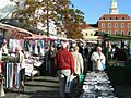
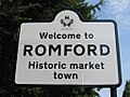
Historically, Romford was a market town in Essex since 1247. It was the main administrative centre for the Royal Liberty of Havering until 1892. Good roads to London and the opening of a railway station in 1839 helped the town grow a lot. Over time, Romford's economy changed from farming to light industry, and then to shops and businesses.
During the 20th century, Romford grew as London expanded. It became a municipal borough in 1937. In 1965, it joined with the Hornchurch Urban District to form the London Borough of Havering. This made Romford part of Greater London. Today, Romford is one of London's biggest areas for shopping, entertainment, and nightlife. In 2011, its population was 122,854 people.
Contents
History of Romford
Romford has a long and interesting history, starting many centuries ago.
What Does the Name Romford Mean?
The name "Romford" first appeared in records in 1177 as Romfort. This name comes from old English words: 'rūm' meaning "wide or spacious" and 'ford" meaning a shallow place in a river where you can cross. So, Romford means "the wide or spacious ford". The River Rom was actually named after the town, not the other way around! This ford was likely on the main road between London and Colchester.
How Romford Grew Over Time
_p57a_-_Romford.jpg)
Romford started as a town in the Middle Ages, located on the main road to London. The important Romford Market began in 1247. The very first part of the town was a bit further south, in an area still called Oldchurch. It moved north to its current spot later in the medieval period to avoid floods from the River Rom. The first building in the new location was the Chapel of St Edward in 1410. This chapel was later replaced by the Parish Church of St Edward the Confessor in 1850.
In its early days, Romford was mostly a farming area. It had many mills for grinding corn. From the 1400s to the early 1800s, the leather industry was important here. Other industries like cloth making, weaving, and brewing also existed.
Transport was key to Romford's growth. The main road to London was improved in 1721. By the 1700s, Romford became a popular stop for coaches.
The Romford Canal Idea
In the early 1800s, there were plans to build a canal to connect Romford to the River Thames. The idea was to transport farm products to London and serve new factories in Romford. Another plan suggested extending the canal to Collier Row to move timber from Hainault Forest to the Royal Dockyards. However, only two miles of the canal were ever built, and it never reached the town.
The Railway Arrives
The town really started to grow faster when the railway station opened in 1839. This boosted the local economy. At first, trains ran between Mile End and Romford. Later, lines extended to Brentwood and Shoreditch. A second station opened in 1892 on South Street, connecting Romford to Tilbury Docks. Both stations were combined into one in 1934.
Light industries grew slowly, reaching their peak in the 1970s. Factories on the edge of town made office machines, wireless parts, and brushes. As more people moved to the suburbs, Romford became an even more important town centre. The Liberty Shopping Centre was built in the 1960s. Later, more shopping centres like The Mall (1990) and The Brewery (2000) were added. The Brewery was built on the site of the old Star Brewery.
How Romford Became a Suburb

Romford started expanding in the 1840s when 200 cottages were built in an area called New Romford. This area was later replaced by new homes in 1961 and named the Waterloo Road Estate, remembering its military past. From 1850, middle-class homes were built east of the market. By 1861, Romford's population had grown to 3,790.
More houses were built outwards from the town for about a mile. Significant growth happened between 1910 and 1911 with the building of Romford Garden Suburb, which included Raphael Park and Gidea Park railway station. Large areas north of the town, like Collier Row, were developed between the two World Wars. After World War II, the London County Council built the Harold Hill estate from 1948 to 1958.
The town got electricity in 1913, first from the Star Brewery, then from Barking Power Station in 1925. Gas supply started in 1825. Romford also became part of London's telephone network in 1899. Water for the town first came from the Havering Well. In 1863, the South Essex Waterworks Company began installing main water pipes.
Romford Cemetery
.jpg)
Romford Cemetery, also known as Crow Lane Cemetery, opened in 1871 when the old churchyard ran out of space. It has old railings, stone gate-piers, and two chapels connected by a gothic archway. Many trees, like holly, cedar, and cherry, grow there. The cemetery also holds the war graves of 118 soldiers from the First and Second World Wars.
How Romford is Governed

Romford is part of the Romford UK Parliament constituency. This area includes several wards (smaller local areas) within Havering: Brooklands, Havering Park, Hylands, Mawneys, Pettits, Romford Town, and Squirrel's Heath.
The Member of Parliament (MP) for Romford since 2001 is Andrew Rosindell from the Conservative Party. Romford is also part of the Havering and Redbridge London Assembly constituency for the Greater London Authority.
Each ward in Romford elects three councillors to the Havering London Borough Council. In the 2018 local elections, all councillors elected for the Romford constituency wards were from the Conservative Party.
Sports in Romford
Romford has several sports teams:
- Romford F.C. is the local football (soccer) team, playing in the Essex Senior League.
- The London Raiders are Romford's ice hockey team.
- The Romford and Gidea Park Rugby Football Club was started in 1927. In 2003, it was one of the first clubs in the UK to have a ladies' rugby team.
Geography of Romford


The centre of Romford is about 50 feet (15 metres) above sea level. The northern parts of the town are higher, up to 150 feet (45 metres) above sea level. The highest point in the area is around the village of Havering-atte-Bower, which is about 344 feet (105 metres) high.
The town centre is mostly surrounded by a ring road. The market place, South Street, and High Street are mainly for pedestrians. The railway line runs through the town on a raised structure called a viaduct. The River Rom flows through Romford in underground channels and eventually joins the River Thames.
Romford has been part of London's continuously built-up area since the 1930s. It connects directly with other areas like Rush Green to the west, Collier Row to the north, Gidea Park to the east, and Hornchurch to the southeast.
Some of the neighbourhoods in Romford include: Collier Row, Gidea Park, Harold Hill, Harold Park, Harold Wood, Havering-atte-Bower, Rise Park and Rush Green.
Romford is located about 14 miles (22.5 km) northeast of central London. It is also:
- 4.75 miles (7.6 km) northeast of Ilford
- 2.5 miles (4 km) north of Dagenham
- 9 miles (14.5 km) northwest of Grays
- 6 miles (9.7 km) southwest of Brentwood
- 12 miles (19.3 km) west of Basildon
- 9 miles (14.5 km) southeast of Epping
Romford's Climate
The weather in Romford is similar to that of Greenwich, which is about 10 miles (16 km) southwest.
| Climate data for London (Greenwich) | |||||||||||||
|---|---|---|---|---|---|---|---|---|---|---|---|---|---|
| Month | Jan | Feb | Mar | Apr | May | Jun | Jul | Aug | Sep | Oct | Nov | Dec | Year |
| Record high °C (°F) | 14.0 (57.2) |
19.7 (67.5) |
21.0 (69.8) |
26.9 (80.4) |
31.0 (87.8) |
35.0 (95.0) |
35.5 (95.9) |
37.5 (99.5) |
30.0 (86.0) |
28.8 (83.8) |
19.9 (67.8) |
15.0 (59.0) |
37.5 (99.5) |
| Mean daily maximum °C (°F) | 8.3 (46.9) |
8.5 (47.3) |
11.4 (52.5) |
14.2 (57.6) |
17.7 (63.9) |
20.7 (69.3) |
23.2 (73.8) |
22.9 (73.2) |
20.1 (68.2) |
15.6 (60.1) |
11.4 (52.5) |
8.6 (47.5) |
15.2 (59.4) |
| Mean daily minimum °C (°F) | 2.6 (36.7) |
2.4 (36.3) |
4.1 (39.4) |
5.4 (41.7) |
8.4 (47.1) |
11.5 (52.7) |
13.9 (57.0) |
13.7 (56.7) |
11.2 (52.2) |
8.3 (46.9) |
5.1 (41.2) |
2.8 (37.0) |
7.5 (45.5) |
| Record low °C (°F) | −10.0 (14.0) |
−9.0 (15.8) |
−8.0 (17.6) |
−2.0 (28.4) |
−1.0 (30.2) |
5.0 (41.0) |
7.0 (44.6) |
6.0 (42.8) |
3.0 (37.4) |
−4.0 (24.8) |
−5.0 (23.0) |
−7.0 (19.4) |
−10.0 (14.0) |
| Average precipitation mm (inches) | 51.6 (2.03) |
38.2 (1.50) |
40.5 (1.59) |
45.0 (1.77) |
46.5 (1.83) |
47.3 (1.86) |
41.1 (1.62) |
51.6 (2.03) |
50.4 (1.98) |
68.8 (2.71) |
58.0 (2.28) |
53.0 (2.09) |
591.8 (23.30) |
| Average rainy days (≥ 1.0 mm) | 10.8 | 8.5 | 9.6 | 9.4 | 9.0 | 8.3 | 8.0 | 7.6 | 8.5 | 10.7 | 10.1 | 9.9 | 110.4 |
| Average snowy days | 4 | 4 | 3 | 1 | 0 | 0 | 0 | 0 | 0 | 0 | 1 | 3 | 16 |
| Average relative humidity (%) | 81.0 | 76.0 | 69.0 | 64.0 | 62.0 | 60.0 | 60.0 | 62.0 | 67.0 | 73.0 | 78.0 | 82.0 | 69.5 |
| Mean monthly sunshine hours | 49.9 | 71.4 | 107.1 | 159.8 | 181.2 | 181.0 | 192.1 | 195.1 | 138.9 | 108.1 | 58.5 | 37.4 | 1,480.5 |
| Source 1: Record highs and lows from BBC Weather, except August and February maximum from Met Office | |||||||||||||
| Source 2: All other data from Met Office, except for humidity and snow data which are from NOAA | |||||||||||||
| Climate data for London (Heathrow airport 1981−2010) | |||||||||||||
|---|---|---|---|---|---|---|---|---|---|---|---|---|---|
| Month | Jan | Feb | Mar | Apr | May | Jun | Jul | Aug | Sep | Oct | Nov | Dec | Year |
| Mean daily maximum °C (°F) | 8.1 (46.6) |
8.4 (47.1) |
11.3 (52.3) |
14.2 (57.6) |
17.9 (64.2) |
21.0 (69.8) |
23.5 (74.3) |
23.2 (73.8) |
19.9 (67.8) |
15.5 (59.9) |
11.1 (52.0) |
8.3 (46.9) |
15.2 (59.4) |
| Mean daily minimum °C (°F) | 2.3 (36.1) |
2.1 (35.8) |
3.9 (39.0) |
5.5 (41.9) |
8.7 (47.7) |
11.7 (53.1) |
13.9 (57.0) |
13.7 (56.7) |
11.4 (52.5) |
8.4 (47.1) |
4.9 (40.8) |
2.7 (36.9) |
7.4 (45.4) |
| Average precipitation mm (inches) | 55.2 (2.17) |
40.9 (1.61) |
41.6 (1.64) |
43.7 (1.72) |
49.4 (1.94) |
45.1 (1.78) |
44.5 (1.75) |
49.5 (1.95) |
49.1 (1.93) |
68.5 (2.70) |
59.0 (2.32) |
55.2 (2.17) |
601.7 (23.68) |
| Average rainy days (≥ 1.0 mm) | 11.1 | 8.5 | 9.3 | 9.1 | 8.8 | 8.2 | 7.7 | 7.5 | 8.1 | 10.8 | 10.3 | 10.2 | 109.6 |
| Mean monthly sunshine hours | 61.5 | 77.9 | 114.6 | 168.7 | 198.5 | 204.3 | 212.0 | 204.7 | 149.3 | 116.5 | 72.6 | 52.0 | 1,632.6 |
| Source: Met Office | |||||||||||||
People and Population (Demography)
The population data for Romford is collected by the Office for National Statistics. In 2001, the population of Romford Town was 13,200, and Brooklands was 13,024, making a total of 26,224 people in these two wards.
In 2011, the Romford Parliament constituency had a total population of 95,894. Most residents (82%) were White British. About 64% of residents reported being Christian.
Life expectancy varies across different areas of Romford. The highest male life expectancy was in Squirrel's Heath (80.7 years), and the highest female life expectancy was in Romford Town (85.7 years).
In 2014, the average house price in Romford Town ward was £225,000. In the Pettits ward, 87.5% of houses were owned by the people living in them.
Romford's Economy


Romford is known as one of the 13 most important "metropolitan centres" in Greater London. This means it's a big hub for shopping and business. In 2002, the town had over 353,000 square metres (3.8 million square feet) of commercial space. About 147,000 square metres (1.6 million square feet) was for shops, and 63,000 square metres (680,000 square feet) was for offices. The amount of retail space has grown even more since then.
Romford also has a business district near the railway station, with offices for companies like Aon. In 2002, about 40% of jobs in the town centre were in commercial offices, and another 40% were in retail. Romford's total business income in 2002 was higher than any other similar town centre in East London.
Romford also has a busy nightlife. There are cinemas, theatres, concert halls, bars, pubs, cafes, and restaurants. The number of people visiting Romford at night for entertainment is almost as high as those visiting during the day for shopping and work.
As of 2012, Romford had over 207,000 square metres (2.2 million square feet) of total town centre space (including shops, leisure, and empty spaces). This made it the fifth largest in Greater London for "town centre vitality and viability," after the West End, Croydon, Kingston upon Thames, and Stratford.
Getting Around Romford (Transport)
Romford has good transport links, making it easy to get to and from the town.
Railway Station

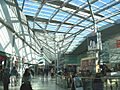
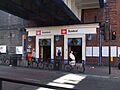
Romford railway station is in London fare zone 6. It is served by Elizabeth line trains that go to Shenfield.
Some Greater Anglia trains also stop here, going to places like Southend Victoria and Colchester Town. There's also a special shuttle train line, called the Liberty line, which runs between Romford and Upminster. This line is operated by London Overground.
Buses
Romford is a major hub for London Buses. You can catch buses to Canning Town, Stratford, Leytonstone, and Dagenham. There are also local buses from large housing areas like Collier Row and Harold Hill. Night bus services run to Stratford, Harold Hill, and Paddington. Romford town centre has a very high "Public Transport Accessibility Level" score, meaning it's very easy to get to by public transport.
There was a plan in 2009 for Romford to be served by a future extension of the East London Transit bus system.
Roads
The A12 trunk road passes north of Romford. The A118 road from Stratford connects with the A127 road (which goes to Southend) at Gallows Corner.
Culture and Entertainment


In 2005, Havering Council wanted to make Romford a cultural place, even though Hornchurch is the main cultural centre of the borough. Romford has many traditional pubs, and two in the market place are historic buildings. The market and nearby streets are also protected as a "conservation area."
For entertainment, Romford has:
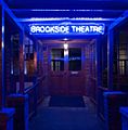
- The Brookside Theatre
- Romford Greyhound Stadium, one of the few remaining dog racing tracks in London
- Two multi-screen cinemas
- Until 2013, the Romford Ice Arena, which was home to the local Romford Raiders ice hockey team.
- The Dolphin Centre was a popular swimming pool from 1982 to 1995.
- There is also a football club called Romford F.C..
- Romford Bowls Club is located in Lodge Farm Park.
Music groups like Department S and Purple Hearts from the 1980s have connections to Romford. The electronic music group Underworld mentions Romford in their famous song "Born Slippy" from the movie Trainspotting.
Ride the sainted rhythms on the midnight train to Romford
Romford was also important for electronic music because of record labels like Strictly Underground and Suburban Base. These labels grew from the Boogie Times record store. In 1992, a Billboard article noted that dance music made in Romford was part of a trend where smaller, local record labels were becoming more popular than big ones in central London.
In 2013, the movie Death Walks was filmed in Romford. The funny TV show Garth Marenghi's Darkplace was set in a made-up hospital in Romford.
The local newspapers for Romford and the Havering area are the Romford Recorder, Romford and Havering Post, and Romford Yellow Advertiser.
Two radio stations are in the area: Time 107.5 and Bedrock Radio (a community health and hospital radio station). A new community radio station, Radio Romford, is planned to start in 2024.
In April 2023, "hoodies," ski masks, and motorcycle helmets were banned in Romford town centre. This was an effort by local businesses and police to help reduce antisocial behaviour.
Premier Cinemas, inside the Mercury Mall, has hosted the Romford Film Festival since 2017, the Romford Horror Film Festival since 2020, and the East London LGBTQ+ Film Festival since 2023.
Images for kids
-
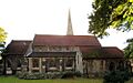
Parish Church of St Edward the Confessor
-
The Liberty Shopping Centre
-
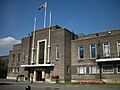
Havering Town Hall
-
Havering Museum
-
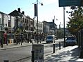
South Street
-
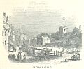
Romford in 1851
-

Romford Urban District (1) absorbed Havering-atte-Bower (2) and Noak Hill (3) in 1934
-
Romford Cemetery entrance
-
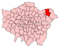
Romford constituency in Greater London
-
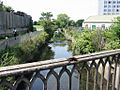
The River Rom emerges from underground channels at Roneo Corner.
-
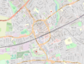
Map of Romford and its environs
-
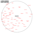
15 mile radius map for Romford
-
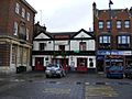
The Lamb Public House in the market place
-
Romford Market
-
Romford railway station
-
Welcome sign at Roneo Corner
-
Brookside Theatre entrance
See also
 In Spanish: Romford para niños
